مريلاند
Maryland | |
|---|---|
| State of Maryland | |
| الكنية: | |
الشعار:
| |
.svg&filetimestamp=20230606014556&) خريطة الولايات المتحدة، موضح فيها Maryland | |
| البلد | الولايات المتحدة |
| قبل الولائية | Province of Maryland |
| انضمت للاتحاد | April 28, 1788 (7th) |
| العاصمة | Annapolis |
| أكبر مدينة | Baltimore |
| أكبر منطقة عمرانية |
|
| Government | |
| • الحاكم | Wes Moore (D) |
| • نائب الحاكم | Aruna Miller (D) |
| المجلس التشريعي | General Assembly |
| • المجلس العلوي | Senate |
| • المجلس السفلى | House of Delegates |
| القضاء | Supreme Court of Maryland |
| سناتورات الولايات المتحدة |
|
| وفد مجلس النواب |
|
| Area | |
• Total | 12٬407 ميل² (32٬133 كم²) |
| • Land | 9٬776 ميل² (25٬314 كم²) |
| • Water | 2٬633 ميل² (6٬819 كم²) 21% |
| • Rank | 42nd |
| Dimensions | |
| • Length | 250 mi (400 km) |
| • Width | 100 mi (200 km) |
| Elevation | 350 ft (110 m) |
| Highest elevation | 3٬360 ft (1٬024 m) |
| Lowest elevation | 0 ft (0 m) |
| Population | |
• Total | 6٬177٬224 |
| • Rank | 18th |
| • Density | 632/sq mi (244/km2) |
| • Rank | 5th |
| • الدخل الأوسط للأسرة | $87٬063 |
| • ترتيب الدخل | 1st |
| Demonym | Marylander |
| اللغة | |
| • اللغة الرسمية | None (English, de facto) |
| Time zone | UTC−05:00 (Eastern) |
| • Summer (DST) | UTC−04:00 (EDT) |
| اختصار البريد | MD |
| ISO 3166 code | US-MD |
| الاختصار التقليدي | Md. |
| خط العرض | 37° 53′ N to 39° 43′ N |
| خط الطول | 75° 03′ W to 79° 29′ W |
| Website | www |
 علم Maryland | |
.svg&filetimestamp=20201003181116&) شعار Maryland | |
 درع Maryland | |
| الأغنية | None. Formerly: "Maryland, My Maryland" by James Ryder Randall (1861), (adopted 1939, repealed 2021) |
|---|---|
| رموز حية | |
| الطائر | Baltimore oriole |
| سلالة قطط | Calico cat |
| القشريات | Blue crab |
| سلالة كلاب | Chesapeake Bay Retriever |
| السمك | Rock fish |
| الزهرة | Black-eyed Susan |
| سلالة الجياد | Thoroughbred |
| الحشرة | Baltimore checkerspot butterfly |
| الزاحف | Diamondback terrapin |
| الشجرة | White oak |
| رموز جامدة | |
| المشروب | Milk |
| الرقصة | Square dance |
| الديناصور | Astrodon johnstoni |
| الطعام | Smith Island cake |
| الأحفورة | Ecphora gardnerae gardnerae |
| الحجر الكريم | Patuxent River stone |
| السفينة | Skipjack |
| الرياضة | |
| علامة طريق ولائي | |
 | |
| ربع دولار الولاية | |
 طـُرِح في 2000 | |
| قوائم رموز الولايات الأمريكية | |
مريلاند (Maryland ؛ US: /ˈmɛrɪlənd/ (![]() استمع) MERR-il-ənd)[ب] هي احدى ولايات الولايات المتحدة الأمريكية تقع علي الساحل الشرقي للولايات المتحدة الامريكية وعاصمتها أنابوليس. اكتسبت أهمية خاصة في المجالات الصناعية والشحن بالسفن. يبلغ عدد سكانها 4,798,622 نسمة. تقع في الجانب الشمالي الشرقي من الولايات المتحدة الجنوبية، وتبلغ مساحتها 27,092 كم² وهي ميناء عالمي وأكبر مدن الولاية. أما أنابولس عاصمة الولاية، فهي مقر الأكاديمية البحرية للولايات المتحدة الأمريكية.
استمع) MERR-il-ənd)[ب] هي احدى ولايات الولايات المتحدة الأمريكية تقع علي الساحل الشرقي للولايات المتحدة الامريكية وعاصمتها أنابوليس. اكتسبت أهمية خاصة في المجالات الصناعية والشحن بالسفن. يبلغ عدد سكانها 4,798,622 نسمة. تقع في الجانب الشمالي الشرقي من الولايات المتحدة الجنوبية، وتبلغ مساحتها 27,092 كم² وهي ميناء عالمي وأكبر مدن الولاية. أما أنابولس عاصمة الولاية، فهي مقر الأكاديمية البحرية للولايات المتحدة الأمريكية.
تُلقب ماريلاند بولاية الصف القديم إشارة إلى الحشود المنتظـمة التي حاربت أثناء الثورة الأمريكية (1775 – 1783). وقد أقيمت العاصمة واشنطن على أرض وهبتها ماريلاند إلى الحكومة الفدرالية للولايات المتحدة الأمريكية في 1791.
Before its coastline was explored by Europeans in the 16th century, Maryland was inhabited by several groups of Native Americans – mostly by Algonquian peoples and, to a lesser degree, Iroquoian and Siouan.[8] As one of the original Thirteen Colonies of England, Maryland was founded by George Calvert, 1st Baron Baltimore, a Catholic convert[9][10] who sought to provide a religious haven for Catholics persecuted in England.[11] In 1632, Charles I of England granted Lord Baltimore a colonial charter, naming the colony after his wife, Henrietta Maria.[12] Unlike the Pilgrims and Puritans, who rejected Catholicism in their settlements, Lord Baltimore envisioned a colony where people of different religious sects would coexist under the principle of toleration.[11] Accordingly, in 1649 the Maryland General Assembly passed an Act Concerning Religion, which enshrined this principle by penalizing anyone who "reproached" a fellow Marylander based on religious affiliation.[13] Nevertheless, religious strife was common in the early years, and Catholics remained a minority, albeit in greater numbers than in any other English colony.
Maryland's early settlements and population centers clustered around rivers and other waterways that empty into the Chesapeake Bay. Its economy was heavily plantation-based and centered mostly on the cultivation of tobacco. Demand for cheap labor from Maryland colonists led to the importation of numerous indentured servants and enslaved Africans. In 1760, Maryland's current boundaries took form following the settlement of a long-running border dispute with Pennsylvania. Maryland was an active participant in the events leading up to the American Revolution, and by 1776, its delegates signed the Declaration of Independence. Many of its citizens subsequently played key political and military roles in the war. In 1790, the state ceded land for the establishment of the U.S. capital of Washington, D.C.
Although then a slave state, Maryland remained in the Union during the American Civil War, its strategic location giving it a significant role in the conflict. After the Civil War, Maryland took part in the Industrial Revolution, driven by its seaports, railroad networks, and mass immigration from Europe. Since the 1940s, the state's population has grown rapidly, to approximately six million residents, and it is among the most densely populated U.S. states. اعتبارا من 2015[تحديث], Maryland had the highest median household income of any state, owing in large part to its proximity to Washington, D.C., and a highly diversified economy spanning manufacturing, retail services, public administration, real estate, higher education, information technology, defense contracting, health care, and biotechnology.[14] Maryland is one of the most multicultural states in the country; it is one of the six states where non-Whites compose a majority of the population, with the fifth-highest percentage of African Americans, and high numbers of residents born in Africa, Asia, Central America, and the Caribbean. The state's central role in U.S. history is reflected by its hosting of some of the highest numbers of historic landmarks per capita.
Sixteen of Maryland's twenty-three counties, as well as the city of Baltimore, border the tidal waters of the Chesapeake Bay estuary and its many tributaries,[15][16] which combined total more than 4,000 miles of shoreline. Although one of the smallest states in the U.S., it features a variety of climates and topographical features that have earned it the moniker of America in Miniature.[17] In a similar vein, Maryland's geography, culture, and history combine elements of the Mid-Atlantic, Northeastern, and Southern regions of the country.
التاريخ


إن ماريلاند المحاذية لفيرجينيا تأسست في العام 1632 عندما منح الملك تشارلز الأول صديقه سيسليوس كالفرت ، لورد بالتيمور الثاني ، نحو اثني عشر فدانا من الأرض شمال نهر بوتومان وجنوب خط الطول الرابع عشر. وعرفانا منه ، أطلق كالفرت على المستعمرة الجديدة اسم زوجة تشارلز الملكة هينريتا ماريا. وهكذا كانت ماريلاند أول مستعمرة خاصة. ذلك أن مقاليد الحكم فيها كانت بيد شركة يملكها شخص واحد ، وقد أمل بالتيمور في تأسيس مستعمرة يتسنى من خلالها لبي طائفته الكاثوليك الهرب من حال الضعف والعجز التي عانوا منها في انجلترا ، وبالطبع لتحقيق دخل جيد من أطيانة الشاسعة التي وصلت مساحتها إلى خمس مساحة انجلترا ، وقد وصلت أولى سفينتين محملتين بالمستعرين – آرك ودوف – في العام 1634.[18]
أرسل بالتيمور أخاف الأصغر ليونارد كالفرت ليضطلح بمنصب الحاكم حيث يرأس حكومة تضاهي حكومة فيرجينيا. ومع أن الكاثوليك لم يمثلوا أغلبية السكان في ماريلاند ، فإن قانون التسامح الذي وضعه مجلس المستعمرة في العام 1649 ضمن حقوق جميع المسيحيين (كما أن يهود المستعمرة – على الرغم من قلة عددهم واستثنائهم من قانون التسامح – لم يعاملوا بسوء). كان هذا أول تشريع من نوعه في التاريخ الأمريكي.
وأصابت ماريلاند ازدهارا سريعا ، ولم يثر الهنود سكانها الأصليون أي مشاكل ، أما أرضها الخصبة ومناخها الدافئ الرطب فكانا مناسبين تماما لزراعة التبغ الذي أصبح بفضل فيرجينيا مصدرا مهما للدخل والأرباح. كما ان إطلالة ماريلاند الواسعة على خليج تشيزابيك بخطوطها الساحلية شديدة التعرج قد وفرت لكثير من أراضيها إمكانات الشحن الرخيص.
وقد أسبغ كالفرت بسخاء حقوق الرأس مع المهاجرين لتشجيعهم على الهجرة إلى المستعمرة ، على الرغم من فرض أجرة إبراء قدرها 4 شلنات عن كل 100 فدان. هذه الرسوم في النظرية القانونية ، كانت تعد من جملة المستحقات الاقطاعية ، ولكنها في التطبيق العملي كانت ضرائب عقارية. وعلى غرار ماحدث في فيرجينيا نشأت على الفور طبقة أرستقراطية إقطاعية – ملاك عدة ألوف من الأفدينة – كان يقابلها أعداد أكبر من المزارعين العاديين. أما من لم يملك أرضا والخدم المستأجرون (المريين) فشكلوا باقي فئات طلائع السكان في وقت بدأ فيه الرق – كما في فيرجينيا – بالإنتشار تدريجيا من التطور الذي شهده الاقتصاد الزراعي (اقتصاد المزارع).
وأصبحت ماريلاند الولاية السابعة في 28 أبريل عام 1788. وأثناء حرب عام 1812م ألهمت معركة بالتيمور فرانسيس سكوت كتابة العلم المرصع بالنجوم، وهو ما أصبح فيما بعد النشيد الوطني للولايات المتحدة. وقد بقيت ماريلاند ضمن ولايات الاتحاد خلال الحرب الأهلية الأمريكية (1861-1865م). وأثناء معركة أنتيتام، التي وقعت بجوار شاربسبورج عام 1862م، مني الشمال والجنوب بخسائر فادحة.
وفي عام 1952م افتتح في بالتيمور جسر خليج تشيسابيك (الآن جسر وليم بلين الابن التذكاري)، كما افتتح عام 1980م في الميناء الداخلي لبالتيمور، سوق الميناء وهو مجمع تجاري ضخم.

في حوالي الساعة 12:30 من صباح يوم الأحد، 21 مارس 2021، انفجر شهاب فوق سماء ولاية مريلاند الأمريكية، والذي ظهر بوضوح فوق پيتسبرگ، كاليفورنيا. حسب شهود العيان، بدا الشهاب أزرق اللون، في حين قال آخرون أنه ظهر كضوء أخضر في وسط نيوجرزي. كما أفادت آخرون أنهم شاهدوا الشهاب بالقرب من واشنطن دي سي، ڤرجينيا، وفلادلفيا.[19]
الجغرافيا
يُقسم خليج تشيسابيك معظم ماريلاند إلى قسمين؛ الساحل الشرقي، والساحل الغربي. ويغطي السهل الساحلي الأطلسي جميع الساحل الشرقي وجزءًا من الساحل الغربي. وتمتد جبال وأودية منطقة بيدمونت غربًا من الساحل لتقابل وسط سلسلة جبال ماريلاند الزرقاء. ويقع شريط ضيق من منطقة سلسلة جبال الأبلاش وواديها غرب سلسلة الجبال الزرقاء. وتمتد مزارع أشجار الفاكهة والحقول في الجزء الذي يقع في وادي هاجرستاون. وتحتل هضبة الأبلاش الحافة الغربية لماريلاند.
الجغرافيا الفيزيائية


الجغرافيا البشرية

الطقس

| Monthly normal high and low temperatures for various Maryland cities | ||||||||||||
| City | Jan | Feb | Mar | Apr | May | Jun | Jul | Aug | Sep | Oct | Nov | Dec |
|---|---|---|---|---|---|---|---|---|---|---|---|---|
| Hagerstown | 38/21 | 42/23 | 52/31 | 63/41 | 74/51 | 82/60 | 86/64 | 84/62 | 77/55 | 66/43 | 54/35 | 43/27 |
| Frederick | 41/25 | 46/27 | 56/35 | 67/44 | 77/54 | 85/62 | 89/67 | 87/66 | 80/59 | 68/47 | 57/38 | 46/30 |
| Baltimore | 44/29 | 47/31 | 57/39 | 68/48 | 77/58 | 86/68 | 91/73 | 88/71 | 81/64 | 70/52 | 59/42 | 49/33 |
| Ocean City | 44/28 | 46/30 | 53/35 | 61/44 | 70/53 | 79/62 | 84/67 | 83/67 | 78/62 | 68/51 | 58/41 | 49/32 |
| [20] | ||||||||||||
الحياة النباتية والحيوانية


توعية بيئية
التوزيع السكاني
| التعداد تاريخياً | |||
|---|---|---|---|
| الإحصاء | التعداد | %± | |
| 1790 | 319٬728 | ||
| 1800 | 341٬548 | 6.8% | |
| 1810 | 380٬546 | 11.4% | |
| 1820 | 407٬350 | 7.0% | |
| 1830 | 447٬040 | 9.7% | |
| 1840 | 470٬019 | 5.1% | |
| 1850 | 583٬034 | 24.0% | |
| 1860 | 687٬049 | 17.8% | |
| 1870 | 780٬894 | 13.7% | |
| 1880 | 934٬943 | 19.7% | |
| 1890 | 1٬042٬390 | 11.5% | |
| 1900 | 1٬188٬044 | 14.0% | |
| 1910 | 1٬295٬346 | 9.0% | |
| 1920 | 1٬449٬661 | 11.9% | |
| 1930 | 1٬631٬526 | 12.5% | |
| 1940 | 1٬821٬244 | 11.6% | |
| 1950 | 2٬343٬001 | 28.6% | |
| 1960 | 3٬100٬689 | 32.3% | |
| 1970 | 3٬922٬399 | 26.5% | |
| 1980 | 4٬216٬975 | 7.5% | |
| 1990 | 4٬781٬468 | 13.4% | |
| 2000 | 5٬296٬486 | 10.8% | |
| تقديري 2008 | 5٬633٬597 | [21] | 6.4% |

العرق
الدين
|
Religions in Maryland | |||||
|---|---|---|---|---|---|
|
Christian |
Other | ||||
| Protestant | 56% | Roman Catholic | 23% | Jewish | 4% |
| Baptist | 18% | Other Christian | 3% | Other Religions | 1% |
| Methodist | 11% | Non-Religious | 13% | ||
| Lutheran | 6% | ||||
| Other Protestant | 21% | ||||
الإقتصاد


تُعتبر بالتيمور من مراكز المال والصناعة والتجارة المهمة في شرقي الولايات المتحدة. وتقوم منطقة بالتيمور بصناعة الرادار وغيره من الأجهزة الكهربائية. وبالتيمور ميناء نشيط يموج بالحركة. وتوجد المراكز الرئيسية لعدة جهات حكومية في مناطق ماريلاند القريبة من العاصمة واشنطن. وكثير من الشركات في ماريلاند تقدم خدماتها للحكومة الفدرالية. والدجاج أهم منتجات المزارع في ماريلاند، أما مصايد الأسماك للولاية فقد تخصصت في صيد المحار والمحار الملزمي.
النقل
الطرق


المطارات
القطارات
قنوات الشحن
الحكومة والقانون
السياسة

التعليم
التعليم الإبتدائي والثانوي

الكليات والجامعات
الرياضة


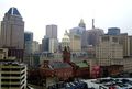
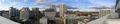
معرض الصور
-
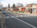
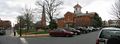
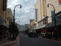
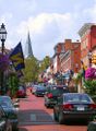 Annapolis
 -
-
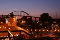
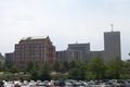
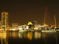 Baltimore's Inner Harbor
 -
-
-
-

-
-
-
-

-

-

-
-

-
-
-
-


أنظر أيضا
المصادر
- ^ "Maryland's quality of life ranks high compared to other states". The Daily Record. Baltimore. December 11, 2004. Retrieved June 4, 2009 – via FindArticles.com.[dead link]
- ^ "Maryland Facts". Maryland Office of Tourism. Retrieved June 2, 2009.
- ^ "Senate Bill 88" (PDF). Archived from the original (PDF) on September 29, 2017.
- ^ "Great Seal of Maryland (reverse)". Maryland State Archives. Retrieved March 4, 2014.
- ^ أ ب "Elevations and Distances in the United States". United States Geological Survey. 2001. Archived from the original on October 15, 2011. Retrieved October 21, 2011.
- ^ "QuickFacts: Maryland". United States Census Bureau. Retrieved April 3, 2022.
- ^ Wells, John C. (2008). Longman Pronunciation Dictionary (3rd ed.). Longman. ISBN 978-1-4058-8118-0.
- ^ "People, Tribes and Bands". Maryland Manual On-line: A Guide to Maryland and its Government. Maryland State Archives. Retrieved August 25, 2019.
- ^ "George Calvert and Cecilius Calvert, Barons Baltimore" William Hand Browne, Nabu Press (August 1, 2010), ISBN 117662539X ISBN 978-1176625396
- ^ Krugler, John D. (2004). English and Catholic : the Lords Baltimore in the seventeenth century. Baltimore: Johns Hopkins University Press. ISBN 978-0801879630. OCLC 53967315.
- ^ أ ب Andrews, Matthew Page (1929). History of Maryland: Province and State. Garden City, New York: Doubleday, Doran & Company, Inc. pp. 3–5.
- ^ "The Charter of Maryland : 1632". avalon.law.yale.edu. December 18, 1998. Retrieved May 2, 2018.
- ^ "Avalon Project—Maryland Toleration Act; September 21, 1649". avalon.law.yale.edu. Retrieved May 3, 2018.
- ^ "State Median Household Income Patterns: 1990–2010". U.S. Census Bureau. Retrieved August 6, 2012.
- ^ Tom Horton; William Chesapeake Bay Foundation (2013). Turning the Tide: Saving the Chesapeake Bay. Island Press. p. 221. ISBN 9781610911160.
- ^ خطأ استشهاد: وسم
<ref>غير صحيح؛ لا نص تم توفيره للمراجع المسماةBaltBrit - ^ "Maryland Facts". Visit Maryland. Retrieved April 25, 2019.
- ^ جون س. جوردون (2008). إمبراطورية الثروة. القاهرة، مصر: سلسلة عالم المعرفة.
{{cite book}}: Cite has empty unknown parameter:|coauthors=(help) - ^ "Hundreds Of People Report Apparent Meteor Lighting Up The Skies Above The East Coast". pittsburgh.cbslocal.com. 2021-03-22. Retrieved 2021-03-22.
- ^ "Average Weather for Ocean City, MD - Temperature and Precipitation". Weather.com. Retrieved 2008-09-22.
- ^ خطأ استشهاد: وسم
<ref>غير صحيح؛ لا نص تم توفيره للمراجع المسماة08CenEst
قراءات إضافية
- Robert J. Brugger. Maryland, A Middle Temperament: 1634-1980 (1996)
- Suzanne Ellery Greene Chappelle, Jean H. Baker, Dean R. Esslinger, and Whitman H. Ridgeway. Maryland: A History of its People (1986)
- Lawrence Denton. A Southern Star for Maryland (1995)
وصلات خارجية
![]() تعريفات قاموسية في ويكاموس
تعريفات قاموسية في ويكاموس
![]() كتب من معرفة الكتب
كتب من معرفة الكتب
![]() اقتباسات من معرفة الاقتباس
اقتباسات من معرفة الاقتباس
![]() نصوص مصدرية من معرفة المصادر
نصوص مصدرية من معرفة المصادر
![]() صور و ملفات صوتية من كومونز
صور و ملفات صوتية من كومونز
![]() أخبار من معرفة الأخبار.
أخبار من معرفة الأخبار.
- Official website of the State of Maryland
- The Official Website for tourism in Maryland
- Energy Data & Statistics for Maryland
- USGS real-time, geographic, and other scientific resources of Maryland
- U.S. Census Bureau
- List of Northeast-region states
- Catholic Encyclopedia article
- Maryland State Facts
- Wikia has a wiki on this subject: Maryland
مريلاند travel guide from Wikitravel
- مريلاند at the Open Directory Project

|
پنسلڤانيا |
| ||
| Delaware | West Virginia | |||
| ڤرجينيا / District of Columbia |
| سبقه {{{before}}} |
{{{title}}} | تبعه {{{after}}} |
39°00′N 76°42′W / 39°N 76.7°W
التاريخ
عاش الهنود الجونكويان والسوسكهانوك في ماريلاند قبل أن يصل الأوروبيون إلى المنطقة. وقد أسس وليم كلايبورن الفرجيني، أول مستوطنة استعمارية عام 1631م، وذلك على جزيرة كنْت. وفي عام 1632م وهب الملك تشارلز الأول المنطقة للورد بالتيمور الثاني. وقد سميت ماريلاند على اسم زوجة الملك، الملكة هنرييتا ماريا.
وأصبحت ماريلاند الولاية السابعة في 28 أبريل عام 1788م. وأثناء حرب عام 1812م ألهمت معركة بالتيمور فرانسيس سكوت كتابة العلم المرصع بالنجوم، وهو ما أصبح فيما بعد النشيد الوطني للولايات المتحدة. وقد بقيت ماريلاند ضمن ولايات الاتحاد خلال الحرب الأهلية الأمريكية (1861-1865م). وأثناء معركة أنتيتام، التي وقعت بجوار شاربسبورج عام 1862م، مني الشمال والجنوب بخسائر فادحة.
وفي عام 1952م افتتح في بالتيمور جسر خليج تشيسابيك (الآن جسر وليم بلين الابن التذكاري)، كما افتتح عام 1980م في الميناء الداخلي لبالتيمور، سوق الميناء وهو مجمع تجاري ضخم.
التوزيع السكاني
| التعداد تاريخياً | |||
|---|---|---|---|
| الإحصاء | التعداد | %± | |
| 1790 | 319٬728 | ||
| 1800 | 341٬548 | 6.8% | |
| 1810 | 380٬546 | 11.4% | |
| 1820 | 407٬350 | 7.0% | |
| 1830 | 447٬040 | 9.7% | |
| 1840 | 470٬019 | 5.1% | |
| 1850 | 583٬034 | 24.0% | |
| 1860 | 687٬049 | 17.8% | |
| 1870 | 780٬894 | 13.7% | |
| 1880 | 934٬943 | 19.7% | |
| 1890 | 1٬042٬390 | 11.5% | |
| 1900 | 1٬188٬044 | 14.0% | |
| 1910 | 1٬295٬346 | 9.0% | |
| 1920 | 1٬449٬661 | 11.9% | |
| 1930 | 1٬631٬526 | 12.5% | |
| 1940 | 1٬821٬244 | 11.6% | |
| 1950 | 2٬343٬001 | 28.6% | |
| 1960 | 3٬100٬689 | 32.3% | |
| 1970 | 3٬922٬399 | 26.5% | |
| 1980 | 4٬216٬975 | 7.5% | |
| 1990 | 4٬781٬468 | 13.4% | |
| 2000 | 5٬296٬486 | 10.8% | |
| تقديري 2008 | 5٬633٬597 | [1] | 6.4% |
العرق
الدين
|
Religions in Maryland | |||||
|---|---|---|---|---|---|
|
Christian |
Other | ||||
| Protestant | 56% | Roman Catholic | 23% | Jewish | 4% |
| Baptist | 18% | Other Christian | 3% | Other Religions | 1% |
| Methodist | 11% | Non-Religious | 13% | ||
| Lutheran | 6% | ||||
| Other Protestant | 21% | ||||
الإقتصاد
تُعتبر بالتيمور من مراكز المال والصناعة والتجارة المهمة في شرقي الولايات المتحدة. وتقوم منطقة بالتيمور بصناعة الرادار وغيره من الأجهزة الكهربائية. وبالتيمور ميناء نشيط يموج بالحركة. وتوجد المراكز الرئيسية لعدة جهات حكومية في مناطق ماريلاند القريبة من العاصمة واشنطن. وكثير من الشركات في ماريلاند تقدم خدماتها للحكومة الفدرالية. والدجاج أهم منتجات المزارع في ماريلاند، أما مصايد الأسماك للولاية فقد تخصصت في صيد المحار والمحار الملزمي.
النقل
الطرق
المطارات
القطارات
قنوات الشحن
الحكومة والقانون
السياسة
التعليم
التعليم الإبتدائي والثانوي
الكليات والجامعات
الرياضة
أنظر أيضا
مرئيات
| انفجار شهاب فوق سماء پيتسبورگ، كاليفورنيا، 21 مارس 2021. |
المصادر
- ^ خطأ استشهاد: وسم
<ref>غير صحيح؛ لا نص تم توفيره للمراجع المسماة08CenEst
للاستزادة
- Robert J. Brugger. Maryland, A Middle Temperament: 1634-1980 (1996)
- Suzanne Ellery Greene Chappelle, Jean H. Baker, Dean R. Esslinger, and Whitman H. Ridgeway. Maryland: A History of its People (1986)
- Lawrence Denton. A Southern Star for Maryland (1995)
وصلات خارجية
- Official website of the State of Maryland
- The Official Website for tourism in Maryland
- Energy Data & Statistics for Maryland
- USGS real-time, geographic, and other scientific resources of Maryland
- U.S. Census Bureau
- List of Northeast-region states
- Catholic Encyclopedia article
- Maryland State Facts
- Wikia has a wiki on this subject: Maryland
مريلاند travel guide from Wikitravel
- مريلاند at the Open Directory Project
|
|
پنسلڤانيا |
| ||
| Delaware | West Virginia | |||
| ڤرجينيا / District of Columbia |
| سبقه {{{before}}} |
{{{title}}} | تبعه {{{after}}} |
39°00′N 76°42′W / 39°N 76.7°W{{#coordinates:}}: لا يمكن أن يكون هناك أكثر من وسم أساسي واحد لكل صفحة
خطأ استشهاد: وسوم <ref> موجودة لمجموعة اسمها "lower-alpha"، ولكن لم يتم العثور على وسم <references group="lower-alpha"/>
- Articles with dead external links from May 2017
- Pages using gadget WikiMiniAtlas
- صفحات ذات وسوم إحداثيات غير صحيحة
- Short description is different from Wikidata
- Pages using infobox settlement with possible nickname list
- Articles containing إيطالية-language text
- Articles containing لاتينية-language text
- Pages using infobox settlement with possible motto list
- Pages using infobox settlement with no coordinates
- Pages including recorded pronunciations
- مقالات فيها عبارات متقادمة منذ 2015
- جميع المقالات التي فيها عبارات متقادمة
- Articles with hatnote templates targeting a nonexistent page
- Pages with empty portal template
- Coordinates on Wikidata
- ولايات أمريكية
- ماريلاند
- Southern states
- Northeastern states
- دول وأراضي تأسست في 1788