سان برناردينو، كاليفورنيا
سان برناردينو، كاليفورنيا
San Bernardino, California | |
|---|---|
 Flag  الشعار  | |
| الكنية: SB؛ سان برناردينو؛ بردو؛ المدينة البوابة؛ المدينة النابضة بالحركة؛ المدينة الصديقة؛ قلب جنوب كاليفورنيا | |
 موقع سان برناردينو في مقاطعة سان برناندو وكاليفورنيا. | |
 سان برناردينو، كاليفورنيا موقع سان برناردينو في الولايات المتحدة. | |
| الإحداثيات: 34°6′N 117°18′W / 34.100°N 117.300°W | |
| البلد | |
| الولاية | |
| المقاطعة | |
| دُمجت | 10 أغسطس 1869[1] |
| السمِيْ | برناردينو من سيينا |
| الحكومة | |
| • النوع | العمدة-المجلس |
| • العمدة | ر. كاري ديڤيز[2] |
| • مدير المدينة | آلن ج. پاركر[3] |
| • أمين الخزانة | ديڤد سي كندي [2] |
| • المدعي العام بالمدينة | گاري ساينز [2] |
| • City clerk | Georgeann Hanna[2] |
| المساحة | |
| • مدينة | 59٫645 ميل² (154٫480 كم²) |
| • البر | 59٫201 ميل² (153٫330 كم²) |
| • الماء | 0٫444 ميل² (1٫15 كم²) 0.74% |
| المنسوب | 1٬053 ft (321 m) |
| التعداد | |
| • مدينة | 209٬924 |
| • Estimate (2013)[6] | 213٬708 |
| • الترتيب | 1 في مقاطعة سان برناردينو 17 في كاليفورنيا 100 في الولايات المتحدة |
| • العمرانية | 4٬224٬851 |
| منطقة التوقيت | UTC−8 (المحيط الهادي) |
| • الصيف (التوقيت الصيفي) | UTC−7 (PDT) |
| الرمز البريدي | 92401–92408, 92410–92415, 92418, 92420, 92423, 92424, 92427 |
| رمز المنطقة | 909 |
| رمز FIPS | 06-65000 |
| GNIS feature IDs | 1661375, 2411777 |
| الموقع الإلكتروني | sbcity |
.jpg&filetimestamp=20230930094039&)
.jpg&filetimestamp=20230930094033&)

_(cropped).jpg&filetimestamp=20230930094028&)
.JPG&filetimestamp=20230930094022&)
سان برناردينو San Bernardino، هي مدينة في منطقة ريڤرسايد-سان برناردينو الحضرية (تسمى أحياناً "إنلاد إمپاير"). تخدم المدينة كمقعد لمقاطعة سان برناردينو، كاليفورنيا، الولايات المتحدة. كإحدى مدن إنلاد إمپاير الرئيسية، تمتد سان برانردينو بمساحة 210 كم² على أرض وادي سان برناردينو، ووصل عدد سكانها في تعداد 2010 إلى 209.924 نسمة.[7] تحتل سان برناردينو الترتيب 17 من بين أكبر مدن كاليفورنيا، والـ100 على مستوى الولايات المتحدة]]. تضم سان برناردينو عدد من البعثات الدبلوماسية، لتصبح واحدة من أربع مدن في كاليفورنيا لديها العديد من القنصليات (الثلاثة الأخرى هي لوس أنجلس، سان دييگو وسان فرانسسكو). أسست حكومات گواتيمالا والمكسيك قنصلياتها في منطقة وسط المدينة.[8]
تقع جامعة ولاية كاليفورنيا، سان برناردينو في شمال غرب المدينة. تستضيف الجامعة أيضاً ملعب كوسوليس. من المعالم السياحية الأخرى في سان برناردينو مسرح فوكس،[9] متحف ماكدونالدز، والذي يقع في الموقع الأصلي لأول فروع ماكدونالدز في العالم، مسرح كاليفورنيا، جبال سان برناردينو، ومدرج سان مانويل، أكبر مدرج بالولايات المتحدة.[10]
Furthermore, the city's University District serves as a college town, as home to California State University, San Bernardino.
San Bernardino was named in 1810, when Spanish priest Francisco Dumetz led an expedition through the area. In 1839, the Mexican government granted Californio ranchero José del Carmen Lugo the right to settle the area, which was formalized when he was granted Rancho San Bernardino in 1842. Following the American Conquest of California, the community on the rancho incorporated as a city in 1854.[11] The city grew significantly in the late 19th century as a commercial hub at the crossroads between Southern California and the American Southwest. Today, San Bernardino is an important hub for the Inland Empire and Southern California.
التاريخ
Indigenous
The city of San Bernardino, California, occupies much of the San Bernardino Valley, a valley long inhabited by the Tongva. Several of their villages dotted the San Bernardino valley prior to the arrival of Europeans in the valley. Kaawchama was perhaps the most significant in the region, being a regional center for trade that was connected to villages in Southern California and the Colorado River through the Mohave Trail, that was used by the Mohave, Serrano, Cahuilla, Payomkawichum, and others.[12][13] The village was located in the eastern expanse of Tovaangar, and was established along the Santa Ana River.[12]
Spanish and Mexican era

With the establishment of Mission San Gabriel in 1771, Spanish missionaries traveling through the area expressed a desire to establish a supply station in the area, which became the Guachama Rancheria.[13] The settlement was also referred to as Politana and became the first Spanish settlement in what they referred to as San Bernardino Valley, named for Bernardino of Siena, being established in 1810 as a mission chapel and supply station by the Mission San Gabriel .[14]
Two years later the settlement was destroyed by local tribesmen, following powerful earthquakes that shook the region. Several years later, the Serrano and Mountain Cahuilla rebuilt the Guachama Rancheria, and in 1819 invited the missionaries to return to the valley. They did and established the San Bernardino de Sena Estancia. Serrano and Cahuilla people inhabited Politana until long after the 1830s decree of secularization and the 1842 inclusion into the Rancho San Bernardino land grant of the José del Carmen Lugo family.[14]
Post-Conquest era

_(16475726449)_(cropped).jpg&filetimestamp=20230930094011&)
The area was not largely settled until 1851, following the American Conquest of California. The first Anglo-American colony was established by pioneers associated with the Church of Jesus Christ of Latter-day Saints. Following the Mormon colonists' purchase of Rancho San Bernardino, and the establishment of the town of San Bernardino in 1851, San Bernardino County was formed in 1853 from parts of Los Angeles County. Mormons laid out the town based on the "City of Zion" plan which was typical of Mormon urban planning.[15] Mormon colonists developed irrigated, commercial farming and lumbering, supplying agricultural produce and lumber throughout Southern California.
The city was officially incorporated in 1857. Later that year, most of the colonists were recalled by Brigham Young in 1857 due to the Utah War. Once highly regarded in early California, news of the Mountain Meadows Massacre poisoned attitudes toward the Mormons. Some Mormons would stay in San Bernardino and some later returned from Utah, but a real estate consortium from El Monte and Los Angeles bought most of the lands of the old rancho and of the departing colonists. They sold these lands to new settlers who came to dominate the culture and politics in the county and San Bernardino became a typical American frontier town. Many of the new land owners disliked the sober Mormons, indulging in drinking at saloons now allowed in the town. Disorder, fighting and violence in the vicinity became common, reaching a climax in the 1859 Ainsworth - Gentry Affair.
In 1860 a gold rush began in the mountains nearby with the discovery of gold by William F. Holcomb in Holcomb Valley early 1860. Another strike followed in the upper reach of Lytle Creek. By the 1860s, San Bernardino had also become an important trading hub in Southern California. The city already on the Los Angeles – Salt Lake Road, became the starting point for the Mojave Road from 1858 and Bradshaw Trail from 1862 to the mines along the Colorado River and within the Arizona Territory in the gold rush of 1862–1864.
.jpg&filetimestamp=20230930094005&)
Near San Bernardino is a naturally formed arrowhead-shaped rock formation on the side of a mountain. It measures 1375 feet by 449 feet. According to the Native American legend regarding the landmark arrowhead, an arrow from Heaven burned the formation onto the mountainside in order to show tribes where they could be healed. During the mid-19th century, "Dr." David Noble Smith claimed that a saint-like being appeared before him and told of a far-off land with exceptional climate and curative waters, marked by a gigantic arrowhead. Smith's search for that unique arrowhead formation began in Texas, and eventually ended at Arrowhead Springs in California in 1857.
By 1889, word of the springs, along with the hotel on the site (and a belief in the effect on general health of the water from the springs) had grown considerably. Hotel guests often raved about the crystal-clear water from the cold springs, which prompted Seth Marshall to set up a bottling operation in the hotel's basement. By 1905, water from the cold springs was being shipped to Los Angeles under the newly created "Arrowhead" trademark.
Indigenous people of the San Bernardino Valley and Mountains were collectively identified by Spanish explorers in the 19th century as Serrano, a term meaning highlander. Serrano living near what is now Big Bear Lake were called Yuhaviatam, or "People of the Pines". In 1866, to clear the way for settlers and gold miners, state militia conducted a 32-day campaign slaughtering men, women, and children.[16] Yuhaviatam leader Santos Manuel guided his people from their ancient homeland to a village site in the San Bernardino foothills. The United States government in 1891 established it as a tribal reservation and named it after Santos Manuel.
In 1867, the first Chinese immigrants arrived in San Bernardino.
In 1883, California Southern Railroad established a rail link through San Bernardino between Los Angeles and the rest of the country.
Modern era
_(cropped).jpg&filetimestamp=20230930094000&)
In 1905, the city of San Bernardino passed its first charter.
Norton Air Force Base was established during World War II. In 1994, Norton Air Force Base closed to become San Bernardino International Airport.
In 1940, Richard and Maurice McDonald founded McDonald's, along with its innovative restaurant concept, in the city.[17]
San Bernardino won the All-America City award in 1977.[18]
In 1989, a massive derailment took place along Duffy street at the Muscoy area, killing 4 people and destroying seven homes. Then on May 25, an underground petroleum pipeline ruptured, killing 2 more people and burning down 11 more homes.
In August 2012, San Bernardino filed for Chapter 9 bankruptcy, with more than $1 billion in debt.[19] The move froze the city's payments to creditors, including its pension payments to the California Public Employees Retirement System for nearly a year. San Bernardino became the largest city at the time to file for a Chapter 9 bankruptcy,[20][21] superseded by Detroit's filing in July 2013. Following a judge's approval, the city emerged from bankruptcy in February 2017, making it one of the longest municipal bankruptcies in the United States.[بحاجة لمصدر]
On December 2, 2015, a terrorist attack left 14 people dead and 22 seriously injured.[22]
القرن 20
_and_the_Stewart_Hotel,_San_Bernardino,_ca.1905_(CHS-5241).jpg&filetimestamp=20190219092734&)
حادث إطلاق النار الجماعي 2015
في 2 ديسمبر 2015، وقع حادث إطلاق نار جماعي في مركز إنلاد الاقليمي بسان برناردينو، كاليفورنيا، أسفر عن مقتل 14 شخص وإصابة 18 آخرين.[23][24][25][26] استهدف المهاجمون حفل لموظفي قسم الرعاية الصحية بمقاطعة سان برناردينو، والذي عقد في قاعة احتفالات بحضور 100 شخص على الأقل،[27][28] قبل الفرار في سيارة رياضية.[29][30]
المهاجمان، سيد رضوان فاروق، وزوجته تاشفين مالك، قُتلا على يد الشرطة بعد تبادل إطلاق النار مع مستقلي السيارة الرياضية.[31] حضر فاروق الحفل كموظف.[31]
يعتبر هذا ثاني أكثر هجوم دموي في تاريخ كاليفورنيا، بعد مذبحة ماكدونالدز سان يسيدرو 1984، والأكثر دموية في أمريكا منذ حادث إطلاق النار في مدرسة ساندي هوك الابتدائية 2012.[32]
الجغرافيا

المناخ

| بيانات المناخ لـ سان برناردينو، كاليفورنيا | |||||||||||||
|---|---|---|---|---|---|---|---|---|---|---|---|---|---|
| الشهر | ينا | فب | مار | أبر | ماي | يون | يول | أغس | سبت | أكت | نوف | ديس | السنة |
| متوسط القصوى اليومية °ف (°س) | 68.4 (20.2) |
69.2 (20.7) |
72.7 (22.6) |
77.8 (25.4) |
83.4 (28.6) |
90.1 (32.3) |
96.2 (35.7) |
97.3 (36.3) |
92.8 (33.8) |
84.0 (28.9) |
74.3 (23.5) |
67.1 (19.5) |
81.1 (27.3) |
| متوسط الدنيا اليومية °ف (°س) | 42.1 (5.6) |
43.6 (6.4) |
45.7 (7.6) |
49.2 (9.6) |
54.3 (12.4) |
58.5 (14.7) |
63.6 (17.6) |
64.2 (17.9) |
60.8 (16.0) |
54.1 (12.3) |
45.5 (7.5) |
41.1 (5.1) |
51.9 (11.1) |
| متوسط تساقط الأمطار inches (mm) | 3.15 (80) |
4.06 (103) |
2.53 (64) |
1.02 (26) |
.25 (6.4) |
.07 (1.8) |
.03 (0.76) |
.13 (3.3) |
.25 (6.4) |
.82 (21) |
1.29 (33) |
2.41 (61) |
16.01 (406.66) |
| Average precipitation days (≥ 0.01 in) | 6.0 | 7.2 | 6.8 | 3.2 | 1.7 | .6 | .5 | .5 | 1.4 | 2.4 | 3.2 | 4.8 | 38.3 |
| Source: NOAA[33] | |||||||||||||
الضواحي والمناطق

الديموغرافيا

| التعداد | Pop. | ملاحظة | %± |
|---|---|---|---|
| 1880 | 1٬673 | — | |
| 1890 | 4٬012 | 139٫8% | |
| 1900 | 6٬150 | 53٫3% | |
| 1910 | 12٬779 | 107٫8% | |
| 1920 | 18٬721 | 46٫5% | |
| 1930 | 37٬481 | 100٫2% | |
| 1940 | 43٬646 | 16٫4% | |
| 1950 | 63٬058 | 44٫5% | |
| 1960 | 91٬922 | 45٫8% | |
| 1970 | 106٬869 | 16٫3% | |
| 1980 | 118٬794 | 11٫2% | |
| 1990 | 164٬164 | 38٫2% | |
| 2000 | 185٬401 | 12٫9% | |
| 2010 | 209٬924 | 13٫2% | |
| 2014 (تق.) | 215٬213 | [34] | 2٫5% |
| التركيبة العرقية | 2010[36] | 1990[37] | 1970[37] | 1940[37] |
|---|---|---|---|---|
| بيض | 45.6% | 60.6% | 83.7% | 97.8% |
| —غير هيسپان | 19.0% | 45.5% | 65.6%[38] | n/a |
| أمريكان سود أو أفارقة | 15.0% | 16.0% | 14.0% | 1.5% |
| هيسپان أو لاتينيون (من أي عرق) | 60.0% | 34.6% | 20.3%[38] | n/a |
| آسيويون | 4.0% | 4.0% | 0.4% | 0.4% |
2010
التنوع العرقي
الاقتصاد

أكبر جهات العمل
| جهة العمل | # موظف |
|---|---|
| جامعة ولاية كاليفورنيا، سان برناردينو | 2,500+ |
| Caltrans District 8 | 1,000+ |
| مدينة سان برناردينو | 1,000+ |
| Community Hospital of San Bernardino | 1,000+ |
| San Bernardino City Unified School District | 1,000+ |
| San Bernardino County Sheriff's Department | 1,000+ |
| San Bernardino County Superintendent of Schools | 1,000+ |
| San Manuel Band of Mission Indians | 1,000+ |
| Stater Bros. Markets | 1,000+ |
| St. Bernardine Medical Center | 1,000+ |
| Wells Fargo Home Mortgage | 1,000+ |
| Omnitrans | 500–999 |
| San Bernardino County Public Works | 500–999 |
| San Bernardino Valley College | 500–999 |
الفنون والثقافة

الأحداث السنوية
المتاحف

الفنون التطبيقية
المنتجعات والسياحة

أسماء التدليل
الرياضة

المنتزهات والترفيه

الحكومة
الحكومة المحلية

هيئات السلطات المشتركة
مقعد المدينة


السلامة العامة
السجون
التمثيل الولائي والفدرالي
التعليم

الكليات والجامعات
- جامعة ولاية كاليفورنيا، سان برناردينو
- كلية سان برناردينو ڤالي
- الجامعة الوطنية، سان برناردينو
- معهد أي تي تي للتكنولوجيا
- معهد الفن في كاليفورنيا - إنلاند إمپاير
- جامعة أرگوسي - إنلاند إمپاير
- كلية إڤرست
- الجامعة الأمريكية للرياضة
- Inland Empire Job Corps Center
- UEI College
- كلية سمت
المدارس الثانوية
الإعلام
البنية التحتية
الرياضة


الطرق والطرق السريعة
خدمة السكك الحديدية
الحافلات
المطارات
المقابر
مشاهير المدينة
مدن شقيقة
|
معرض الصور
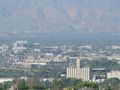
أفق سان برناردينو.
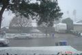
تساقط الثلوج بغزارة في سان برناردينو.
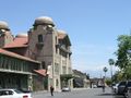
سان برناردينو، محطة أمتراك، سانت فه ديپوت.


انظر أيضاً
المصادر
- ^ "California Cities by Incorporation Date" (Word). California Association of Local Agency Formation Commissions. Retrieved August 25, 2014.
- ^ أ ب ت ث "Elected Officials". City of San Bernardino. Retrieved September 18, 2014.
- ^ "City Manager's Office". City of San Bernardino. Retrieved January 24, 2015.
- ^ قالب:Cite US Gazetteer
- ^ "San Bernardino". نظام معلومات الأسماء الجغرافية، المسح الجيولوجي الأمريكي. Retrieved December 3, 2014.
- ^ أ ب "San Bernardino (city) QuickFacts". United States Census Bureau. Retrieved March 20, 2015.
- ^ http://factfinder2.census.gov/faces/tableservices/jsf/pages/productview.xhtml?pid=DEC_10_PL_GCTPL1.ST13&prodType=table#
- ^ http://www.pe.com/local-news/local-news-headlines/20140307-immigration-guatemala-to-open-san-bernardino-consulate.ece
- ^ "American Sports University". American Sports University. Retrieved September 5, 2012.
- ^ San Manuel Stadium History
- ^ "City of San Bernardino - Local History".
- ^ أ ب Zappia, Natale A. (2014). Traders and raiders : the indigenous world of the Colorado Basin, 1540-1859. Chapel Hill. pp. 77, 179. ISBN 978-1-4696-1585-1. OCLC 883632043.
Wa'aachnga, also known as Kaawchama. This village became the site of present-day Redlands and the location of the San Bernardino Asistencia, built in 1820.
{{cite book}}: CS1 maint: location missing publisher (link) - ^ أ ب Crafts, E. P. R. (1906). Pioneer Days in the San Bernardino Valley. Redlands, California: Kingsley, Moles & Collins Co. pp. 12–13. ISBN 9783849680169.
- ^ أ ب Caballeria y Collell, Juan (March 6, 1902). "History of San Bernardino Valley from the padres to the pioneers, 1810-1851". [San Bernardino, Cal., Times-index Press – via Internet Archive.
- ^ "City Planning – the Encyclopedia of Mormonism".
- ^ "History". San Manuel Band of Mission Indians. Archived from the original on August 23, 2014. Retrieved November 6, 2014.
- ^ Modern Marvels "Fast Food Tech"; History Channel; Viewed December 3, 2009
- ^ "Past Winners". National Civic League. Retrieved 16 March 2018.
- ^ "San Bernardino, California, files for bankruptcy with over $1 billion in debts". Reuters. August 2, 2012. Retrieved June 12, 2017.
- ^ خطأ استشهاد: وسم
<ref>غير صحيح؛ لا نص تم توفيره للمراجع المسماةCBS20120711 - ^ خطأ استشهاد: وسم
<ref>غير صحيح؛ لا نص تم توفيره للمراجع المسماةBW20120817 - ^ "'The worst thing imaginable:' Bodies and blood everywhere after San Bernardino terrorist attack, DOJ report shows". Los Angeles Times. September 9, 2016.
- ^ خطأ استشهاد: وسم
<ref>غير صحيح؛ لا نص تم توفيره للمراجع المسماةlosangelestimes - ^ Rosenfeld, Everette. "Upwards of 14 people dead in San Bernardino mass shooting: Police department chief". CNBC. Retrieved December 2, 2015.
- ^ خطأ استشهاد: وسم
<ref>غير صحيح؛ لا نص تم توفيره للمراجع المسماةNYT - ^ Myers, Amanda. "14 dead, more than a dozen wounded in California shooting". Associated Press. Retrieved December 2, 2015.
- ^ "14 people killed in shooting at San Bernardino social services facility". ABC Eyewitness News. Retrieved December 2, 2015.
- ^ "At Least 14 Dead After California Shooting". Sky News. December 2, 2015.
- ^ "12 people killed in shooting at San Bernardino social services facility". ABC7 Los Angeles. Retrieved December 2, 2015.
- ^ "California shooting: 'Multiple deaths' at San Bernardino centre". BBC News. December 2, 2015. Retrieved December 2, 2015.
- ^ أ ب (December 3, 2015). Suspects in San Bernardino mass shooting identified as Syed Farook and Tashfeen Malik. ABC7. Retrieved: December 3, 2015.
- ^ Jon Schuppe. "San Bernardino Shooting is Deadliest Since Newtown". NBC News.
- ^ "Station Name: CA SAN BERNARDINO F S 226". National Oceanic and Atmospheric Administration. Retrieved July 3, 2013.
{{cite web}}: Unknown parameter|deadurl=ignored (|url-status=suggested) (help) - ^ "Annual Estimates of the Resident Population for Incorporated Places: April 1, 2010 to July 1, 2014". Retrieved June 4, 2015.
- ^ "Census of Population and Housing". Census.gov. Retrieved June 4, 2015.
- ^ "San Bernardino (city), California". State & County QuickFacts. U.S. Census Bureau.
- ^ أ ب ت "Race and Hispanic Origin for Selected Cities and Other Places: Earliest Census to 1990". U.S. Census Bureau.
- ^ أ ب From 15% sample
قراءات إضافية
- كتب
- Edward Leo Lyman, San Bernardino: The Rise and Fall of a California Community, Signature Books, 1996.
- Walter C. Schuiling, San Bernardino County: Land of Contrasts, Windsor Publications, 1984
- Nick Cataldo, Images of America: San Bernardino, California, Arcadia Publishing, 2002
- مقالات
- James Fallows (May 2015), What It's Like When Your City Goes Broke. "San Bernardino, California, is poor, has a high unemployment rate, is affected by drought, and is in bankruptcy court. But its real problem is something else."
وصلات خارجية
| Find more about San Bernardino, California at Wikipedia's sister projects | |
| Definitions from Wiktionary | |
| Media from Commons | |
| Quotations from Wikiquote | |
| Source texts from Wikisource | |
| Textbooks from Wikibooks | |
| Learning resources from Wikiversity | |
- Official website
- California Welcome Center in San Bernardino
- City of San Bernardino at the Internet Archive
أماكن قريبة من سان برناردينو، كاليفورنيا | |
|---|---|
| موضوعات | | |
|---|---|---|
| الضواحي | ||
| النقل | ||
| السياحة | ||
| التعليم العالي (غير ربحي) | ||
مقالات أخرى متعلقة بسان برناردينو | |||||||||||||||||||||||||
|---|---|---|---|---|---|---|---|---|---|---|---|---|---|---|---|---|---|---|---|---|---|---|---|---|---|
قالب:San Bernardino County, California
| |||||||||||||||||||||||||

_(16475726449)_(cropped).jpg&filetimestamp=20230930094011)
.jpg&filetimestamp=20230930094005)
_(cropped).jpg&filetimestamp=20230930094000)
_and_the_Stewart_Hotel,_San_Bernardino,_ca.1905_(CHS-5241).jpg&filetimestamp=20190219092734)
- CS1 maint: location missing publisher
- CS1: Julian–Gregorian uncertainty
- CS1 errors: unsupported parameter
- Articles with hatnote templates targeting a nonexistent page
- Short description with empty Wikidata description
- Pages using multiple image with auto scaled images
- Pages using gadget WikiMiniAtlas
- Articles with unsourced statements from June 2017
- Pages using US Census population needing update
- Portal-inline template with redlinked portals
- Pages with empty portal template
- Pages using columns-list with unknown parameters
- سان برناردينو، كاليفورنيا
- مدن مقاطعة سان برناردينو، كاليفورنيا
- عواصم مقاطعات كاليفورنيا
- ضواحي سان برناردينو، كاليفورنيا
- أماكن مأهولة في إنلاند إمپاير (كاليفورنيا)
- أماكن مأهولة على نهر سانتا آنا
- مدن وبلدات مدمجة في كاليفورنيا
- إنلاند إمپاير (كاليفورنيا)
- أماكن مأهولة تأسست في 1869
- تأسيسات 1869 في كاليفورنيا
- Government units that have filed for Chapter 9 bankruptcy