الإقليم الأوسط الجنوبي الشرقي
East South Central | |
|---|---|
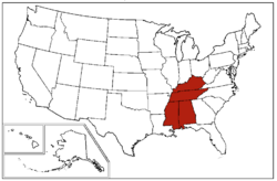
 States in dark red make up the East South Central states region | |
| Largest city | Nashville |
| المساحة | |
| • الإجمالي | 183٬403٫90 ميل² (475٬013٫9 كم²) |
| • البر | 178٬289٫84 ميل² (461٬768٫6 كم²) |
| • الماء | 5٬114٫07 ميل² (13٬245٫4 كم²) |
| التعداد (2019)[2] | |
| • الإجمالي | 19٬176٬181 |
| • الكثافة | 100/sq mi (40/km2) |
الإقليم الأوسط الجنوبي الشرقي يتكون من أربع ولايات وهي: ولاية كنتكي ، ولاية تنسي، ولاية ألباما، وولاية مسيسيبي. وتبلغ مساحة هذا الإقليم 471,286 كم²، وسكانه في سنة 2019 كانوا 19,176,181 نسمة. The division is one of three that together make up the larger region known as the Southern United States (the other two are the more populous South Atlantic states and the West South Central states).
Historically, the area has been colonized and influenced by the French, Spanish, British, early American, and Confederate governments.[3][4][5][6] Distinct among these states, Alabama's French culture has been preserved through the Alabama Creoles,[7] and Kentucky's French culture can be observed throughout Louisville.[8] The East South Central states form the core of Old Dixie,[9] one of the nine moral regions identified by James Patterson and Peter Kim in their acclaimed 1991 geopolitical best-seller, The Day America Told The Truth.[10] Politically and culturally, the East South Central is more conservative than the other regions making up the American South; Mississippi, Alabama, and Tennessee's governments have been described during 2012 to 2023 as some of the most conservative.[11][12][13] Religiously, conservative Evangelical Protestantism dominates the East South Central as a central part of the Bible Belt.
السكان
As of 2020, the East South Central states had a combined population of 19,430,030. The East South Central region covers 183,401 square miles of land. Within the region, Tennessee is the largest state by population, though Alabama is the largest by land area; Tennessee was also the East South Central's fastest growing state between 2010 and 2020,[14][15] with Alabama second.[16] Kentucky was the third-fastest growing state,[17] and Mississippi experienced population decline; despite population decline, Mississippi did increase in diversity.[18][19]
| State | 2020 Estimate | Land Area |
|---|---|---|
| Alabama | 5,039,877 | 52,419 |
| Kentucky | 4,509,342 | 40,409 |
| Mississippi | 2,963,914 | 48,430 |
| Tennessee | 6,916,897 | 42,143 |
| City | 2020 Pop. | |
|---|---|---|
| 1 | Nashville, Tennessee | 689,447 |
| 2 | Memphis, Tennessee | 633,104 |
| 3 | Louisville, Kentucky | 633.045 |
| 4 | Lexington, Kentucky | 322,707 |
| 5 | Huntsville, Alabama | 215,006 |
| 6 | Birmingham, Alabama | 200,733 |
| 7 | Montgomery, Alabama | 200,663 |
| 8 | Knoxville, Tennessee | 190,740 |
| 9 | Mobile, Alabama | 187,041 |
| 10 | Chattanooga, Tennessee | 181,009 |
السياسة
| Parties | ||||||||
| Nonpartisan | Democratic-Republican | Democratic | National Republican | Whig | Constitutional Union | Republican | Dixiecrat | American Independent |
- Bold denotes election winner.
الموقع
يقع هذا الإقليم في النطاق الجنوب الشرقي من السهول الوسطي ، إلى الشرق من نهر المسيسبي ويحده من الشمال نهر أهايو ، وحيث الإقليم الأوسط الشمالي الشرقي ، ومن الجنوب خليج المكسيك ، ومن الشرق ولايات الأطلنطي الجنوبي ، ويشكل حدوده الغربية نهر المسيسبي .
الأرض
سهلية في جملتها ، فهى قسم من السهول الوسطي ، وترتفع نحو الشرق حيث هضبة كمبرلاند ، وسلاسل جبال الليجاني ( المقدمة الغربية لجبال الأبلاش ) . وتنحدر الأرض تدريجياً نحو الغرب إلى نهر المسيسبي ، وكذلك نحو الجنوب إلى خليج المكسيك ، ولاتخلو أرضه من بعض مظاهر التضرس فتشوب أرضه بعض التلال ، وتقطعها المجاري النهرية العديدة المنحدرة من جبال الأبلاش .
المناخ
ينتمي إلى النمط شبه المداري الرطب ،حيث الصيف الحار والشتاء الدافىء .وتغزوه أحياناً موجات باردة في الشتاء ، ومعظم الامطار تسقط في فصل الصيف وإن كانت لاتنقطع في باقي الفصول ، والنبات الطبيعي من الغابات المختلطة والحشائش .
النشاط البشري
النشاط البشري يتمثل في الزراعة وتربية الحيوان وهي دعامة هامة في اقتصاديات الإقليم ، وأبرز الحاصلات ، القطن ، والذرة ، وفول الصويا ، والتبغ ، والقمح ( في المناطق المرتفعة ) ، والأرز ، وقصب السكر . ويستخرج الفحم من ولاية ألاباما كذلك الأسمنت ، وتسير الصناعة قدماً في هذا الإقليم ، وبه العديد من مصادرها ، وهناك العديد من الصناعات في ولاية مسيسبي وبلغ عدد المصانع فيها في سنة (1400 هـ -1980 م ) ،3058مصنعاً .وتشمل الصناعة في هذا النطاق ، الصناعات البترولية ، والبتروكيميائية، وصناعة الخشب ، والمواد الغذائية ،وحلج القطن ،والمنسوجات ، والملابس القطنية ،وصناعة الحديد.
المصدر
- الإقليات المسلمة في الأمريكتين والبحر الكاريبي - سيد عبد المجيد بكر.
المراجع
- ^ "United States Summary: 2010, Population and Housing Unit Counts, 2010 Census of Population and Housing" (PDF). United States Census Bureau. September 2012. pp. V–2, 1 & 41 (Tables 1 & 18). Retrieved February 7, 2014.
- ^ "Population, Population Change, and Estimated Components of Population Change: April 1, 2010 to July 1, 2019 (NST-EST2019-alldata)". Census.gov. United States Census Bureau. Archived from the original on January 26, 2020. Retrieved 8 February 2020.
- ^ Pinnen, Christian; Weeks, Charles (2021). Colonial Mississippi: A Borrowed Land. University Press of Mississippi. ISBN 978-1-4968-3270-2.
- ^ "National Park Service - Explorers and Settlers (Alabama)". www.nps.gov. Retrieved 2023-01-25.
- ^ "Tennessee". HISTORY (in الإنجليزية). Retrieved 2023-01-25.
- ^ "Kentucky Genealogical Society - Kentucky History". kygs.org (in الإنجليزية). Retrieved 2023-01-25.
- ^ Blejwas, Emily (2020-02-19). "Gumbo: Africans and Creoles on the Gulf Coast". Mobile Bay Magazine (in الإنجليزية الأمريكية). Retrieved 2023-01-25.
- ^ "Timeline of Louisville, KY". Louisville Kentucky Government.
- ^ Dreher, Rod (2021-09-10). "The Day They Drove Old Dixie Down". The American Conservative (in الإنجليزية الأمريكية). Retrieved 2023-01-25.
- ^ "LITTLE GOOD NEWS IN `THE DAY AMERICA TOLD THE TRUTH`". Chicago Tribune. Retrieved 2023-01-25.
- ^ "Mississippi Most Conservative State, D.C. Most Liberal". Gallup.com (in الإنجليزية). 2012-02-03. Retrieved 2023-01-25.
- ^ "Alabama Has the Most Conservative Legislature in the Nation". Governing (in الإنجليزية). 2022-12-06. Retrieved 2023-01-25.
- ^ "CLA Report: Tennessee Ties For Second Most-Conservative State House". MemphisFlyer. Retrieved 2023-01-25.
- ^ "2020 Census Data: Tennessee Population Topping 6.9 Million". News (in الإنجليزية الأمريكية). 2021-04-28. Retrieved 2023-01-25.
- ^ Yu, Yue Stella. "2020 Census results: Middle Tennessee drives population growth as state becomes more racially diverse". The Tennessean (in الإنجليزية الأمريكية). Retrieved 2023-01-25.
- ^ "Alabama Population Grew 5.1% Since 2010, Surpassing 5 Million". Census.gov. Retrieved 2023-01-25.
- ^ "Kentucky Population Topped 4.5 Million in 2020". Census.gov. Retrieved 2023-01-25.
- ^ "Census shows Mississippi lost population and diversified". AP NEWS (in الإنجليزية). 2021-04-26. Retrieved 2023-01-25.
- ^ Newsom, Michael (2022-02-02). "UM Experts Warn About Consequences of Population Loss". Ole Miss News (in الإنجليزية الأمريكية). Retrieved 2023-01-25.
- CS1 الإنجليزية الأمريكية-language sources (en-us)
- Pages using gadget WikiMiniAtlas
- Short description matches Wikidata
- Short description is different from Wikidata
- Pages using infobox settlement with missing country
- Pages using infobox settlement with no coordinates
- Coordinates on Wikidata
- Regions of the Southern United States
- Census regions of the United States


