أبلاست كاليننگراد
أوبلاست كاليننگراد | |
|---|---|
| Калининградская область | |
 ميدان النصر في كاليننگراد. | |
 Flag  Coat of arms | |
| النشيد: نشيد أوبلاست كاليننگراد | |
 | |
| الإحداثيات: 54°48′N 21°25′E / 54.800°N 21.417°E | |
| البلد | روسيا |
| المنطقة الاتحادية | الشمالية الغربية[1] |
| المنطقة الاقتصادية | كاليننگراد[2] |
| تأسست | 7 أبريل 1946[3] |
| المركز الإداري | كاليننگراد |
| الحكومة | |
| • الكيان | دوما أوبلاست كاليننگراد[4] |
| • الحاكم[5] | أنطون عليخانوڤ |
| المساحة | |
| • Total | 15٬100 كم² (5٬800 ميل²) |
| ترتيب المساحة | رقم 76 |
| التعداد (2010 Census)[7] | |
| • Total | 941٬873 |
| • Estimate (يناير 2020)[8] | 1٬012٬253 |
| • الترتيب | رقم 56 |
| • الكثافة | 62/km2 (160/sq mi) |
| • Urban | 77٫6% |
| • الريف | 22٫4% |
| منطقة التوقيت | UTC+2 (توقيت كالينينغراد |
| ISO 3166 code | RU-KGD |
| لوحات السيارات | 39, 91 |
| OKTMO ID | 27000000 |
| اللغات الرسمية | الروسية[10] |
| الموقع الإلكتروني | http://www.gov39.ru |


أوبلاست كاليننگراد (روسية: Калинингра́дская о́бласть, romanized: Kaliningradskaya oblast'، إنگليزية: Kaliningrad Oblast)، هو كيان اتحادي روسي يقع في أقصى غرب البلاد. وهو شبه-منعزل، ويطل على بحر البلطيق. أكبر مدن الأوبلاست ومركزه الإداري هي مدينة كاليننگراد، التي كانت تُعرف باسم كونيگزبرگ. ميناء-مدينة الأوبلاست هو بالتيسك، وهو الميناء الروسي الوحيد على بحر البلطيق الذي لا تتجمد مياهه في الشتاء. في تعداد 2010 كان عدد سكان الأوبلاست 1 مليون نسمة.[7]
تحده پولندا من الجنوب، لتوانيا من الشمال والشرق، وبحر البلطيق من الغرب. من المستحيل السفر براً بين الأوبلاست والجزء الرئيسي المتاخم لروسيا دون المرور عبر دولتين أخريين على الأقل. كانت المنطقة في السابق تمثل الجزء الشمالي من المقاطعة الپروسية في پروسيا الشرقية، والجزء الجنوبي منها هو اليوم جزء من ڤويڤودية ڤارمين-ماسوريان في پولندا. مع هزيمة ألمانيا النازية في الحرب العالمية الثانية، ضم الاتحاد السوڤيتي الإقليم كجزء من روسيا الاشتراكية السوڤيتية. بعد الهجرة ما بعد الحرب وفرار وطرد الألمان، كان معظم سكان الإقليم من الروس.
التاريخ
كونيگزبرگ

The territory of what is now the Kaliningrad Oblast used to be inhabited by the Old Prussians and other Western Balts, prior to the Teutonic conquest in the early Late Middle Ages.[12] The Old Prussians became extinct due to Germanisation in the first half of the 18th century.[13] The Lithuanian-inhabited areas of the Teutonic State were known as Lithuania Minor, which encompassed all of modern Kaliningrad Oblast until the 18th century.[13]
Late Middle Ages
In the 13th century, the Teutonic Order conquered the region and established a monastic state.[14] In 1255, on the foundations of a destroyed Sambian settlement known as Tvanksta, the Teutonic Order founded the city of Königsberg (modern Kaliningrad), naming it in honour of Ottokar II of Bohemia.[15]
The Northern Crusades, including the Lithuanian Crusade, were partly motivated by colonization.[16] The German colonist peasants, craftsmen, and merchants were predominantly concentrated in the southern part of the Teutonic State and did not move into Nadruvia and Skalvia due to the Lithuanian military threat.[16]
القرن 15
After Poland's victory in the Thirteen Years' War (1454–1466) with the Second Peace of Thorn, the State of the Teutonic Order became a vassal of the Kingdom of Poland.[13] During this war, the capital of the Teutonic state was moved from Marienburg (now Malbork) to Königsberg in 1457.[13] Following the war, Royal Prussia was established on part of the Teutonic Order's territory.[17] When the rulers of the Duchy of Prussia were vassals of the King of Poland from 1466 to 1660, there were few German colonists.[13]
  تاريخ براندنبورگ وپروسيا | |||
| التخوم الشمالية قبل القرن 12 |
الپروس القدماء قبل القرن 13 | ||
| مارگراڤية براندنبورگ 1157–1618 (1806) |
أوردنشتات 1224–1525 | ||
| دوقية بروسيا 1525–1618 |
پروسيا (الپولندية) الملكية 1466–1772 | ||
| براندنبورگ-پروسيا 1618–1701 | |||
| مملكة پروسيا 1701–1772 | |||
| مملكة پروسيا 1772–1918 | |||
| دولة پروسيا الحرة 1918–1947 |
منطقة كلايپيدا (لتوانيا) 1920–1939 / 1945–الحاضر | ||
| براندنبورگ (ألمانيا) 1947–1952 / 1990–الحاضر |
الأراضي المستعادة (پولندا) 1918/1945–الحاضر |
أوبلاست كاليننگراد (روسيا) 1945–الحاضر | |
16th century
After the Teutonic Order lost the war of 1519–1521 with Poland, the Teutonic Order remained a vassal of the Kingdom of Poland.[18] In 1525, Grand Master Albert of Brandenburg secularized the Teutonic Order's Prussian branch and established himself as ruler of the Duchy of Prussia, the first Protestant state in Europe.[18] Königsberg was the residence of the Duke of Prussia from 1525 until 1701,[15] and was the Duchy of Prussia's capital until 1660, when the capital moved to Berlin.[15]
In 1577, the Duke of Prussia forbade serfs—who were mostly Old Prussians, Lithuanians, and Masurians—to leave the land that was the property of the German knights who became proprietary nobles.[19]
17th century
In 1618, the Duchy merged with the Margraviate of Brandenburg to form Brandenburg-Prussia.[12]
18th century
During the Seven Years' War, the region was occupied by the Russian Empire. It was then reorganized into the Province of East Prussia within the Kingdom of Prussia in 1773. The territory of the Kaliningrad Oblast lies in the northern part of East Prussia. The territory was briefly occupied and annexed by Russia in 1758 during the Seven Years' War before being returned to Prussia in 1762 when Russia switched sides in the war.[20]
19th century
Napoleonic occupation
After the defeats of Jena–Auerstedt, the Kingdom of Prussia was invaded and Berlin was occupied by the French. The Court of Prussia fled to Königsberg, asking for Russian help. Russia intervened, leading to the bloody Battle of Eylau and Battle of Friedland in 1807. Following a French victory in the latter, both sides signed the Treaties of Tilsit.[20]
Historical ethnic and religious structure
In 1817, East Prussia had 796,204 Protestants, 120,123 Catholics, 2,389 Jews, and 864 Mennonites.[21]
In 1824, shortly before its merger with West Prussia, the population of East Prussia was 1,080,000 people.[22] According to Karl Andree, Germans were slightly more than half of the people, while 280,000 (~26%) were ethnically Polish and 200,000 (~19%) were ethnically Lithuanian.[23] As of 1819, there were also 20,000-strong[مطلوب توضيح] ethnic Curonian and Latvian minorities as well as 2,400 Jews, according to Georg Hassel.[24] Similar numbers are given by August von Haxthausen in his 1839 book, with a breakdown by county.[25] However, the majority of East Prussian Polish and Lithuanian inhabitants were Lutherans, not Catholics like their ethnic kinsmen across the border in the Russian Empire. Only in Southern Warmia (German: Ermland), Catholic Poles—so called Warmians (not to be confused with predominantly Protestant Masurians)—comprised the majority of population, numbering 26,067 people (~81%) in county Allenstein (Polish: Olsztyn) in 1837.[25] Another minority in 19th-century East Prussia were ethnically Russian Old Believers, also known as Philipponnen, who mainly lived in the town of Eckersdorf (Wojnowo).[26][27][28]
German culture and Germanization
In the 19th century, East Prussia was commonly viewed by German commentators as culturally backwards and a part of the "German mission in the East" rather than a core German territory. Pan-Germanist politician Ernst Hasse criticised the lack of folk identity and imagined community: "It is the case that there is almost no common folk identity [Landsmannschaften] among the Poseners and Prussians at all. [...] Who can recognise a Posener or Prussian by dialect and character? Distinct features hardly exist."[29] While the north of East Prussia was overwhelmingly German, the south was majority Slavic and mostly composed of Poles and Masurians. There was also a slight Lithuanian majority in the north-eastern area of East Prussia, Lithuania Minor.[30] Regional and local identities were particularly strong in East Prussia - local Polish population often identified with Masuria rather than Poland, and Prussian Lithuanians also did not actively identify themselves with the Lithuanian nation.[31] Moreover, confessional identity often prevailed over the national one - German authorities were concerned about the "Catholic-Polish axis"; German Catholics were alienated from the German nation because of the Kulturkampf legislation, and tended to support the Polish national movement. An East German newspaper Thorner Zeitung reported in 1871 that "not only Polish Catholics, but also a great number of German Catholics, are willing to vote for a Polish party candidate".[32]
By the end of the 19th century, East Prussia had a significant Polish minority, and German nationalist circles warned of the prospect of Polonization of East Prussia.[33] The perceived weakness of Germanness of East Prussia was also reinforced by the Ostflucht, as East Prussia suffered from both under-industrialisation and rural overpopulation. After 1876, farm prices in East Prussia fell by 20 percent, which encouraged local landowners to hire foreign workers from Congress Poland, incidentally strengthening the Polish element in the region. The increased Slavic immigration to the region generated by the requirement of the Junkers for cheap labour and better economic conditions in West Germany caused many German inhabitants to leave the region.[34] Most Germans moved to work in the industrial heartland of western Germany, while others migrated abroad. Poles and Lithuanians of East Prussia also had much higher birth-rate and natural increase rates than the Germans, and rarely emigrated.[35] Discussing the situation in East Prussia, Polish geographer Stanisław Srokowski remarked:
The Poles who live in the southern and western parts of East Prussia and the Lithuanians of the north-west have succeeded better than the Germans in reconciling their mode of life with their earnings. This has, of course, led to a lower standard of life, but it has enabled them to adapt themselves to actual conditions and even to prosper where the Germans fail. Moreover, both these national minorities in East Prussia are bound to the soil by centuries of tradition: they are not comparative new-comers like the majority of the Germans there. For these reasons, the Poles and Lithuanians in that province hardly ever emigrate from the land of their birth, especially as the emigration in question is not so attractive for them as for the Germans: proceeding to central or western Germany, the former would really be going to a foreign country, amongst people not speaking their language and having other customs than theirs.[36]
The Memel Territory (Klaipėda region), formerly part of northeastern East Prussia as well as Prussian Lithuania, was annexed by Lithuania in 1923. In 1938, Nazi Germany radically renamed about a third of the place names of this area, replacing Old Prussian and Lithuanian names with newly invented German names.
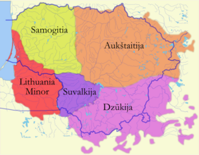
Historic Lithuania Minor (red) comprised the eastern part of the Prussian region that is now Kaliningrad Oblast.

Curonian spit in 1649, inhabited by the Kursenieki
East Prussian resort town of Cranz (Zelenogradsk today) as it looked circa 1900. It was a destination for German artists and intelligentsia.


20th century
World War I
In September 1914, after hostilities began between Germany on the one hand and France and Russia on the other, the Reich was about to seize Paris, and the French urged Russia to attack East Prussia. Nicholas II launched a major attack, resulting in a Russian victory in the Battle of Gumbinnen. The Russian army arrived at the outskirts of the city of Königsberg but did not take it and settled at Insterburg. This Russian victory and East Prussia's occupation by Russia saved Paris by forcing the Germans to send many troops to their East provinces.[37] Later, Hindenburg and Ludendorff pushed Russia back at the battle of Tannenberg, thereby liberating East Prussia from Russian troops. Yet Russian troops remained in the easternmost part of the region until early 1915.[38]
World War II
On 29 August 1944, Soviet troops reached the border of East Prussia. By January 1945, they had taken all of East Prussia except for the area around Königsberg. Many inhabitants fled west at this time. During the last days of the war, over two million people fled, anticipating imminent Red Army conquest, and were evacuated by sea.
Soviet annexation
Under the Potsdam Agreement of 1 August 1945, the city became part of the Soviet Union pending the final determination of territorial borders at an anticipated peace settlement. This final determination eventually took place on 12 September 1990 when the Treaty on the Final Settlement with Respect to Germany was signed. The excerpt from the initial agreement pertaining to the partition of East Prussia, including the area surrounding Königsberg, is as follows (note that Königsberg is spelt "Koenigsberg" in the original document):
VI. CITY OF KOENIGSBERG AND THE ADJACENT AREA
The Conference examined a proposal by the Soviet Government that pending the final determination of territorial questions at the peace settlement, the section of the western frontier of the Union of Soviet Socialist Republics which is adjacent to the Baltic Sea should pass from a point on the eastern shore of the Bay of Danzig to the east, north of Braunsberg – Goldep, to the meeting point of the frontiers of Lithuania, the Polish Republic and East Prussia.The Conference has agreed in principle to the proposal of the Soviet Government concerning the ultimate transfer to the Soviet Union of the city of Koenigsberg and the area adjacent to it as described above, subject to expert examination of the actual frontier.
The President of the United States and the British Prime Minister supported the proposal of the Conference at the forthcoming peace settlement.[39]

Königsberg was renamed Kaliningrad in 1946 after the Chairman of the Presidium of the Supreme Soviet of the USSR Mikhail Kalinin, although Kalinin was unrelated to the city, and there were already cities named in honour of Kalinin in the Soviet Union, namely Kalinin (now Tver) and Kaliningrad (now Korolev, Moscow Oblast).[40][41]
Some historians speculate that it may have originally been offered to the Lithuanian SSR because the resolution from the conference specifies that Kaliningrad's border would be at the (pre-war) Lithuanian frontier. The remaining German population was forcibly expelled between 1947 and 1948. The annexed territory was populated with Soviet citizens, mostly ethnic Russians but to a lesser extent also Ukrainians and Belarusians.[42]
The German language was replaced with the Russian language. In 1950, there were 1,165,000 inhabitants, which was only half the number of the pre-war population.
From 1953 to 1962, a monument to Stalin stood on Victory Square. In 1973, the town hall was turned into the House of Soviets. In 1975, the trolleybus was launched again. In 1980, a concert hall was opened in the building of the former Lutheran Church of the Holy Family. In 1986, the Kreuzkirche building was transferred to the Russian Orthodox Church.
For foreigners, the city was completely closed and, with the exception of rare visits of friendship from neighboring Poland, it was practically not visited by foreigners.[43][44]
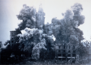
The old city was not restored, and the ruins of the Königsberg Castle were demolished in the late 1960s,[45] on Leonid Brezhnev's personal orders,[45][46] despite the protests of architects, historians, local historians and ordinary residents of the city.[47][48][49]
The "reconstruction" of the oblast, threatened by hunger in the immediate post-war years, was carried out through an ambitious policy of oceanic fishing[50] with the creation of one of the main fishing harbours of the USSR in Kaliningrad city. Fishing not only fed the regional economy but also was a basis for social and scientific development, in particular oceanography.[51]
In 1957, an agreement was signed and later came into force which delimited the border between Polish People's Republic (Soviet satellite state at the time) and the Soviet Union.[52][53]
The region was added as a semi-exclave to the Russian SFSR; since 1946 it has been known as the Kaliningrad Oblast. According to some historians, Stalin created it as an oblast separate from the Lithuanian SSR because it further separated the Baltic states from the West.[54] Others think that the reason was that the region was far too strategic for the USSR to leave it in the hands of another SSR other than the Russian one.[51] The names of the cities, towns, rivers, and other geographical features were changed to Russian names.
The area was administered by the planning committee of the Lithuanian SSR, although it had its own Communist Party committee.[بحاجة لمصدر] In the 1950s, Nikita Khrushchev offered the entire Kaliningrad Oblast to the Lithuanian SSR but Antanas Sniečkus refused to accept the territory because it would add at least a million ethnic Russians to Lithuania proper.[42][55]
In 2010, the German magazine Der Spiegel published a report claiming that Kaliningrad had been offered to Germany in 1990 (against payment). The offer was not seriously considered by the West German government which, at the time, saw reunification with East Germany as a higher priority.[56] However, this story was later denied by Mikhail Gorbachev.[57]
Recent history


The collapse of the Soviet Union and full dissolution in 1991 exacerbated Kaliningrad's isolation. Since the Baltic states became independent, Kaliningrad Oblast has been separated from the rest of Russia by other countries rather than by other Soviet republics. Neighboring Lithuania became an independent country in 1991. The isolation became more severe when both Poland and Lithuania became members of NATO. In 2004, Poland and Lithuania joined the European Union and imposed strict border controls on Kaliningrad Oblast. All military and civilian land links between the region and the rest of Russia now must pass through members of NATO and the EU. Thus far, the EU has rejected Russian proposals for visa-free travel between the EU and Kaliningrad. Travel arrangements based on the Facilitated Transit Document (FTD) and Facilitated Rail Transit Document (FRTD) have been made.[59][60] Kaliningrad Oblast's geographic isolation has badly affected its economic situation. Concurrent significant reduction in the size of the Russian military garrison has hurt as well, since previously the military was a major local employer.
Some of the cultural heritage, most notably the Königsberg Cathedral, were restored in the 1990s, as citizens started to examine previously ignored German past.[61]
On 12 January 1996, Kaliningrad Oblast and Sverdlovsk Oblast became the first oblasts of Russia to sign a power-sharing treaty with the federal government, granting them autonomy. However, this agreement was abolished on 31 May 2002.[62]
After 1991, some ethnic Germans immigrated to the area, such as Volga Germans from other parts of Russia and Kazakhstan, especially after Germany raised the requirements[مطلوب توضيح] for people from the former Soviet Union to be accepted as ethnic Germans and have a "right of return".[بحاجة لمصدر]

These Germans are overwhelmingly Russian-speaking and as such were rejected for resettlement within Germany under Germany's new rules. A similar migration by Poles from the lands of the former Soviet Union to the Kaliningrad Oblast occurred at this time as well. The situation has begun to change, albeit slowly. Germany, Lithuania, and Poland have renewed contact with Kaliningrad Oblast, through town twinning and other projects. This has helped to promote interest in the history and culture of the East Prussian and Lietuvininkai communities.
In July 2007, Russian First Deputy Prime Minister Sergei Ivanov declared that if US-controlled missile defense systems were deployed in Poland, then nuclear weapons might be deployed in Kaliningrad. On 5 November 2008, Russian president Dmitry Medvedev said that installing missiles in Kaliningrad was almost a certainty.[63] These plans were suspended in January 2009,[64] but implemented in October 2016.[65] In 2011, a long-range Voronezh radar was commissioned to monitor missile launches within about 6،000 km (3،700 mi). The radar is situated in the settlement of Pionersky in Kaliningrad Oblast.[66]
A few months after the 2022 Russian invasion of Ukraine, Lithuania started implementing EU sanctions, which blocked about 50% of the goods being imported into Kaliningrad by rail. Food, medicine, and passenger travel were exempted. Russia protested against the sanctions and announced it would increase shipments by sea.[67][68]
كانت كونيگزبرگ هي العاصمة الأصلية لپروسيا من 1525 حتى 1701، لكن پروسيا توسعت غرباً، ليصبح موقع العاصمة متطرفاً للغاية وأصبحت برلين هي العاصمة الپروسية الجديدة.
الموقع الذي تشغله كاليننگراد الآن كان في السابق موقع مدينة كونيگزبرگ في پروسيا الشرقية. تأسست عام 1255 من قبل الفرسان التيوتون في موقع مستوطنة تڤانگسته الپروسية القديمة، وسميت المدينة على شرف البوهيمي الملك أوتوكار الثاني. خلال فترات الألمنة والاستعمار على مدى القرون التالية، أصبحت الثقافة الألمانية مسيطرة، مع عدد كبير من الأقليات الپولندية واللتوانية وانقرض السامبيون الأصليون في القرن السابع عشر. خلال الحرب العالمية الثانية، دمرت مدينة كونيگزبرگ إلى حد كبير.
پروسيا الشرقية
تاريخ براندنبورگ وپروسيا | |||
| التخوم الشمالية قبل القرن 12 |
الپروس القدماء قبل القرن 13 | ||
| مارگراڤية براندنبورگ 1157–1618 (1806) |
أوردنشتات 1224–1525 | ||
| دوقية بروسيا 1525–1618 |
پروسيا (الپولندية) الملكية 1466–1772 | ||
| براندنبورگ-پروسيا 1618–1701 | |||
| مملكة پروسيا 1701–1772 | |||
| مملكة پروسيا 1772–1918 | |||
| دولة پروسيا الحرة 1918–1947 |
منطقة كلايپيدا (لتوانيا) 1920–1939 / 1945–الحاضر | ||
| براندنبورگ (ألمانيا) 1947–1952 / 1990–الحاضر |
الأراضي المستعادة (پولندا) 1918/1945–الحاضر |
أوبلاست كاليننگراد (روسيا) 1945–الحاضر | |
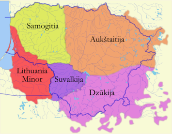
تتألف لتوانيا الصغرى من جزء كبير من پروسيا التي تشكل حالياً أوبلاست كاليننگراد.
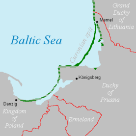
عام 1649، امتدت تسوية كورسنيكي الناطقة باللاتڤية من كلايپيدا إلى گدانسك. جرى ألمنتها في بداية الحرب العالمية الثانية.

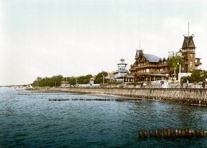
بلدة كرانز الپروسية الشرقية السابقة كما كانت تبدو ح. 1900. هي الآن مدينة-منتجع زلنوگرادسك. قبل عام 1945، كانت وجهة شهيرة للفنانين والمثقفين الألمان.
الاتحاد السوڤيتي
دخول الجيش الأحمر
في 29 أغسطس 1944، أثناء الحرب العالمية الثانية، وصلت القوات السوڤيتية إلى حدود پروسيا الشرقية. في يناير 1945، اجتاح الجيش الأحمر جميع أراضي پروسيا الشرقية باستثناء المنطقة المحيطة بكونيگزبرگ. في ذلك الوقت فر العديد من السكان إلى الغرب. خلال الأيام الأخيرة من الحرب، كان أكثر من مليوني شخص منهم تم إجلاؤهم بحراً. حُكم على السكان الباقين، البالغ عددهم حوالي 300 ألف ألماني، بالسخرة وتعرضوا للمجاعة والأوبئة.
پوتسدام
في نهاية الحرب عام 1945، أصبحت المدينة جزءًا من الاتحاد السوڤيتي بانتظار التحديد النهائي للمسائل الإقليمية في تسوية السلام (كجزء من روسيا السوڤيتية) اتفق عليه الحلفاء في مؤتمر پوتسدام:
6. مدينة كونيگزبرگ والمنطقة المجاورة
درس المؤتمر اقتراحًا من الحكومة السوڤيتية بأنه في انتظار الفصل النهائي للمسائل الإقليمية عند التسوية السلمية، فإن قسم الحدود الغربية لاتحاد الجمهوريات الاشتراكية السوڤيتية المتاخم لبحر البلطيق يجب أن يمر من نقطة على الشاطئ الشرقي لخليج خليج دانزيگ إلى الشرق، شمال براونسبيرگ وگولداپ، إلى نقطة التقاء حدود ليتوانيا والجمهورية الپولندية وپروسيا الشرقية.وافق المؤتمر من حيث المبدأ على اقتراح الحكومة السوڤيتية بشأن النقل النهائي لمدينة كونيگزبرگ والمنطقة المجاورة لها إلى الاتحاد السوڤيتي كما هو موصوف أعلاه، رهناً بفحص الخبراء للحدود الفعلية.
أعلن رئيس الولايات المتحدة و رئيس الوزراء البريطاني أنهما سيؤيدان اقتراح المؤتمر في التسوية السلمية المقبلة.[69]
كاليننگراد

ادماجها في ج. روسيا الاتحادية ا.س.
روسيا الاتحادية
العزلة

الجغرافيا


Kaliningrad is the only Russian Baltic Sea port that is ice-free all year and hence plays an important role in the maintenance of the country's Baltic Fleet.
The oblast is mainly flat, as the highest point is the 230 m (750 ft) Gora Dozor hill near the tripoint of the Poland–Russia border/Lithuania–Russia border.[70]
As a semi-exclave of Russia, it is surrounded by Poland (Pomeranian and Warmian-Masurian Voivodeships), Lithuania (Klaipėda, Marijampolė, and Tauragė Counties) and the Baltic Sea. The end of the river Neman forms part of the Lithuania–Russia border.
Notable geographical features include the Curonian Lagoon (shared with Lithuania) and the Vistula Lagoon (shared with Poland). The oblast's largest river is the Pregolya. The river starts as a confluence of the Instruch and the Angrapa and drains into the Baltic Sea through the Vistula Lagoon. Its length, strictly under the name "Pregolya", is 123 km (76 mi); when including the Angrapa, is it 292 km (181 mi) long.
تشمل السمات الجغرافية البارزة ما يلي:
- لاگون كورونيان (مشتركة مع ليتوانيا)
- لاگون ڤيستولا (مشترك مع پولندا)
المدن والبلدات الرئيسية:
| الروسية | الألمانية † | الليتوانية † | الپولندية † | |
|---|---|---|---|---|
| بالتيسك | Балтийск | Pillau | Piliava | Piława |
| خرنياخوڤسك | Черняховск | Insterburg | Įsrutis | Wystruć |
| گوسڤ | Гусев | Gumbinnen | Gumbinė | Gąbin |
| كاليننگراد | Калининград | Königsberg | Karaliaučius | Królewiec |
| سوڤيتسك | Советск | Tilsit | Tilžė | Tylża |
† ما قبل عام 1946 (تم استخدام الأسماء الألمانية أيضاً باللغة الإنگليزية في هذه الفترة)
المناخ
Kaliningrad Oblast has a climate gradually transitioning from oceanic to humid continental depending on distance from the Baltic Sea moderation. It remains very mild by Russian standards with winters above freezing without the hot summers associated with the Russian interior on similar latitudes. The local climate is slightly wetter than similar latitudes further west, but infrequent ice days lead to low snow accumulation regardless.
| بيانات المناخ لـ Kaliningrad (1991–2020, extremes 1848–present) | |||||||||||||
|---|---|---|---|---|---|---|---|---|---|---|---|---|---|
| الشهر | ينا | فب | مار | أبر | ماي | يون | يول | أغس | سبت | أكت | نوف | ديس | السنة |
| القصوى القياسية °س (°ف) | 12.7 (54.9) |
16.9 (62.4) |
23.0 (73.4) |
28.5 (83.3) |
30.6 (87.1) |
34.0 (93.2) |
36.3 (97.3) |
36.5 (97.7) |
33.8 (92.8) |
26.4 (79.5) |
19.4 (66.9) |
13.3 (55.9) |
36.5 (97.7) |
| متوسط القصوى اليومية °س (°ف) | 1.1 (34.0) |
2.1 (35.8) |
6.1 (43.0) |
13.1 (55.6) |
18.2 (64.8) |
21.3 (70.3) |
23.5 (74.3) |
23.3 (73.9) |
18.4 (65.1) |
12.2 (54.0) |
6.2 (43.2) |
2.6 (36.7) |
12.3 (54.1) |
| المتوسط اليومي °س (°ف) | −1.2 (29.8) |
−0.6 (30.9) |
2.4 (36.3) |
7.9 (46.2) |
12.7 (54.9) |
16.1 (61.0) |
18.5 (65.3) |
18.1 (64.6) |
13.5 (56.3) |
8.4 (47.1) |
3.9 (39.0) |
0.4 (32.7) |
8.3 (46.9) |
| متوسط الدنيا اليومية °س (°ف) | −3.5 (25.7) |
−3.0 (26.6) |
−0.8 (30.6) |
3.4 (38.1) |
7.5 (45.5) |
11.3 (52.3) |
13.9 (57.0) |
13.3 (55.9) |
9.4 (48.9) |
5.2 (41.4) |
1.7 (35.1) |
−1.8 (28.8) |
4.7 (40.5) |
| الصغرى القياسية °س (°ف) | −32.5 (−26.5) |
−33.3 (−27.9) |
−21.7 (−7.1) |
−5.8 (21.6) |
−3.1 (26.4) |
0.7 (33.3) |
4.5 (40.1) |
1.6 (34.9) |
−2.0 (28.4) |
−11.1 (12.0) |
−18.7 (−1.7) |
−25.6 (−14.1) |
−33.3 (−27.9) |
| متوسط تساقط الأمطار mm (inches) | 68 (2.7) |
54 (2.1) |
49 (1.9) |
38 (1.5) |
52 (2.0) |
69 (2.7) |
91 (3.6) |
91 (3.6) |
73 (2.9) |
86 (3.4) |
76 (3.0) |
69 (2.7) |
816 (32.1) |
| متوسط عمق الثلج الكثيف cm (inches) | 7 (2.8) |
7 (2.8) |
3 (1.2) |
0 (0) |
0 (0) |
0 (0) |
0 (0) |
0 (0) |
0 (0) |
0 (0) |
2 (0.8) |
5 (2.0) |
7 (2.8) |
| Average rainy days | 14 | 13 | 14 | 14 | 14 | 16 | 15 | 16 | 17 | 18 | 18 | 16 | 185 |
| متوسط الرطوبة النسبية (%) | 85 | 83 | 78 | 72 | 71 | 74 | 75 | 77 | 81 | 83 | 86 | 87 | 79 |
| Mean monthly ساعات سطوع الشمس | 35 | 61 | 120 | 171 | 253 | 264 | 257 | 228 | 158 | 96 | 38 | 26 | 1٬707 |
| Source 1: Pogoda.ru.net[71] | |||||||||||||
| Source 2: NOAA (sun 1961–1990)[72] | |||||||||||||
التقسيمات الادارية
السكان
المستوطنات
| Largest cities or towns in Kaliningrad Oblast | |||
|---|---|---|---|
| Name | Administrative Division | Pop. | Image |
| Kaliningrad | City of oblast significance of Kaliningrad | 498,260 | 
|
| Chernyakhovsk | Chernyakhovsky District | 39,126 | 
|
| Sovetsk | Town of oblast significance of Sovetsk | 38,514 | 
|
| Baltiysk | Baltiysky District | 33,946 | 
|
| Gusev | Gusevsky District | 28,177 | |
| Svetly | Town of oblast significance of Svetly | 21,441 | |
| Guryevsk | Guryevsky District | 19,670 | |
| Zelenogradsk | Zelenogradsky District | 17,296 | |
| Svetlogorsk | Svetlogorsky District | 16,099 | |
| Gvardeysk | Gvardeysky District | 13,353 | |
الجماعات العرقية
وفقًا لتعداد عام 2010، كان التكوين العرقي للأوبلاست على النحو التالي:[7]
- 772.534 الروس (86.4%)
- 32.771 الأوكران (3.7%)
- 32.497 البلاروس (3.6%)
- 9.769 اللتوان (1.1%)
- 9.226 الأرمن (1%)
- 7.349 الألمان (0.8%)
- 4.534 التتار (0.5%)
- 3.282 أذريون (0.4%)
- 2.788 پولنديون (0.3%)
- 2.245 أوزبك (0.3%)
- 16.857 أخرى (1.9%)
- تم تسجيل 48.021 شخصًا من قواعد البيانات الإدارية ولم يتمكنوا من إعلان العرقية. تشير التقديرات إلى أن نسبة العرقيات في هذه المجموعة هي نفس نسبة المجموعة المعلنة.[73]
| التعداد [74] | 1959 | 1970 | 1979 | 1989 | 2002 | 2010 |
|---|---|---|---|---|---|---|
| الروس | 473.861 (77.6%) | 564.469 (77.1%) | 632.717 (78.3%) | 683.563 (78.5%) | 786.885 (82.4%) | 772.534 (86.4%) |
| الأوكرانيون | 35.717 (5.8%) | 48.044 (6.6%) | 54.656 (6.8%) | 62.750 (7.2%) | 47.229 (4.9%) | 32.771 (3.7%) |
| بلاروس | 57.178 (9.4%) | 68.808 (9.4%) | 72.465 (9.0%) | 73.926 (8.5%) | 50.748 (5.3%) | 32.497 (3.6%) |
| لتوانيون | 21.262 (3.5%) | 23.376 (3.2%) | 19.647 (2.4%) | 18.116 (2.1%) | 13.937 (1.5%) | 9.769 (1.1%) |
معدل الخصوبة الإجمالي [75]
| السنة | المعدل |
|---|---|
| 2000 | 1.11 |
| 2001 | 1.10 |
| 2002 | 1.21 |
| 2003 | 1.24 |
| 2004 | 1.20 |
| 2005 | 1.16 |
| 2006 | 1.20 |
| 2007 | 1.40 |
| 2008 | 1.45 |
| 2009 | 1.48 |
| 2010 | 1.46 |
| 2011 | 1.52 |
| 2012 | 1.63 |
| 2013 | 1.64 |
| 2014 | 1.70 |
| 2015 | 1.75 |
| 2016 | 1.73 |
| 2017 | 1.57 |
الدين
الآراء الدينية في أوبلاست كاليننگراد (2012)[76][77]
وفقًا لمسح رسمي عام 2012[76] فإن 34% من سكان أوبلاست كاليننگراد أعلنوا أنفسهم "روحانيين وليس دينيين"، 30.9% أتباع الكنيسة الأرثوذكسية الروسية، 22% ملحدين و11.1% يتبعون ديانات أخرى أو لم يعطوا إجابة على السؤال، 1% من المسيحيين الغير طائفيين و1% من أتباع الكنيسة الكاثوليكية.[76]
حتى عام 1945 ، كان غالبية سكان المنطقة من اللوثريين، مع عدد قليل من الكاثوليك واليهود.
الاقتصاد

في 2021، كان الناتج المحلي الإجمالي الاسمي للأبلاست 7 مليار دولار و7000 دولار للفرد.[78]
يستمد الأوبلاست ميزة اقتصادية من موقعه الجغرافي كميناء خالٍ من الجليد وقربه من الاتحاد الأوروپي. كما أن لديه أكبر رواسب في العالم من العنبر. طورت المنطقة بنيتها التحتية السياحية وعززت عوامل الجذب مثل برزخ كورش.[79]
لمعالجة معدل البطالة المرتفع في الأوبلاست، منحت السلطات الروسية عام 1996 الأوبلاست وضعًا اقتصاديًا خاصًا مع حوافز ضريبية تهدف إلى جذب المستثمرين. استفاد اقتصاد الأوبلاست بشكل كبير منذ ذلك الحين، وفي السنوات الأخيرة شهد[when?] طفرة. أُفتتحت محطة مطار بقيمة 45 مليون دولار أمريكي وتقدم المفوضية الأوروپية الأموال لمشاريع الأعمال في إطار برنامجها الخاص للمنطقة. زادت التجارة مع دول الاتحاد الأوروپي. وزاد الناتج الاقتصادي..[80]
وفقًا للإحصاءات الرسمية، عام عام 2006 بلغ الناتج الإقليمي الإجمالي 115 مليار روبل.[81] عام 207 بلغ نصيب الفرد من إجمالي الناتج المحلي 155.669 روبل.[82]
الصناعة
Car and truck assembly (GM, BMW, Kia, Yuejin by Avtotor) and the production of auto parts are major industries in Kaliningrad Oblast. There are shipbuilding facilities in Kaliningrad and Sovetsk. Food processing is a mature industry in the region, with Miratorg operating a sizeable food processing factory. OKB Fakel, a world leader in the field of Hall thruster development, as well as a leading Russian developer and manufacturer of electric propulsion systems, is based in Neman. The company employs 960 people.[83][84] General Satellite (GS) is the biggest employer in Gusev city, manufacturing products such as satellite receivers, cardboard packaging, and nanomaterials.
الموارد الطبيعية
More than 90% of the world's known amber deposits are in Kaliningrad Oblast .[85] Because of this, many Russians refer to the region as "Amber Land" (روسية: Янтарный Край, romanized: Jantarny Krai). Until recently, raw amber was exported for processing to other countries. In 2013, the Russian government banned the export of raw amber in order to boost the amber processing industry in Russia.[86]
There are small oil reservoirs beneath the Baltic Sea not far from Kaliningrad's shore. Small-scale offshore exploration started in 2004. Poland, Lithuania, and some local NGOs voiced concerns about possible environmental effects.
صيد الأسماك
Fishing is an important regional industry, with big fishing ports in Kaliningrad and Pionersky. There are smaller fishing ports in Svetly and Rybachy.
توليد الطاقة

Average yearly power consumption in the Kaliningrad Oblast was 3.5 terawatt-hours in 2004, of which local power generation provided just 0.235 terawatt-hours. The balance was imported from neighbouring countries. A new Kaliningrad power station was built in 2005, providing 50% of the oblast's energy needs. This station was expanded in 2010, making the oblast independent from electricity imports.
In 2008, planning began for the construction of two nuclear power reactors, with costs estimated at €5 billion (US$8 billion).[87] The project was suspended in May 2013. In 2014, the project was abandoned in response to environmental concerns and lack of support.[88]
LNG from St. Petersburg supplies some of the energy in the Oblast.[89]
انظر أيضاً
- انتخابات أوبلاست كاليننگراد، 2011
- الحزب الجمهوري البلطيقي
- قائةم المحليات الريفية في أوبلاست كاليننگراد
- منطقة أوبلاست كاليننگراد الخاصة
المراجع
- ^ Президент Российской Федерации. Указ №849 от 13 мая 2000 г. «О полномочном представителе Президента Российской Федерации в федеральном округе». (President of the Russian Federation. Decree #849 of May 13, 2000 On the Plenipotentiary Representative of the President of the Russian Federation in a Federal District).
- ^ Госстандарт Российской Федерации. №ОК 024-95 27 декабря 1995 г. «Общероссийский классификатор экономических регионов. 2. Экономические районы», в ред. Изменения №5/2001 ОКЭР. (گوستاندارت of the Russian Federation. #OK 024-95 December 27, 1995 Russian Classification of Economic Regions. 2. Economic Regions, as amended by the Amendment #5/2001 OKER).
- ^ Charter of Kaliningrad Oblast, Article 3
- ^ Charter of Kaliningrad Oblast, Article 17
- ^ Charter of Kaliningrad Oblast, Article 28
- ^ Федеральная служба государственной статистики (Federal State Statistics Service) (2004-05-21). "Территория, число районов, населённых пунктов и сельских администраций по субъектам Российской Федерации (Territory, Number of Districts, Inhabited Localities, and Rural Administration by Federal Subjects of the Russian Federation)". Всероссийская перепись населения 2002 года (All-Russia Population Census of 2002) (in الروسية). Federal State Statistics Service. Retrieved 2011-11-01.
- ^ أ ب ت Russian Federal State Statistics Service (2011). "Всероссийская перепись населения 2010 года. Том 1". Всероссийская перепись населения 2010 года (2010 All-Russia Population Census) (in Russian). Federal State Statistics Service. Retrieved June 29, 2012.
{{cite web}}: Invalid|ref=harv(help); Unknown parameter|trans_title=ignored (|trans-title=suggested) (help)CS1 maint: unrecognized language (link) - ^ "Archived copy". Archived from the original on 24 January 2020. Retrieved 6 November 2020.
{{cite web}}: CS1 maint: archived copy as title (link) - ^ "Об исчислении времени". Официальный интернет-портал правовой информации (in الروسية). 3 June 2011. Retrieved 19 January 2019.
- ^ الرسمية في جميع أرجاء روسيا الاتحادية حسب الفقرة 68.1 من دستور روسيا.
- ^ Weir, Fred (July 26, 2015). "Living on Prussia's ruins, Kaliningraders embrace Germanic past". Christian Science Monitor. Retrieved 25 July 2017.
- ^ أ ب Matulevičius, Algirdas. "Prūsija" [Prussia]. VLE (in الليتوانية). Retrieved 2022-05-13.
- ^ أ ب ت ث ج Matulevičius, Algirdas; Kaunas, Domas. "Mažoji Lietuva" [Lithuania Minor]. VLE (in الليتوانية). Retrieved 2022-05-13.
- ^ Gudavičius, Edvardas. "Vokiečių ordinas" [German Order]. VLE (in الليتوانية). Retrieved 2022-05-13.
- ^ أ ب ت Matulevičius, Algirdas; Purvinas, Martynas. "Karaliaučiaus istorija". VLE (in الليتوانية). Retrieved 2022-05-13.
- ^ أ ب Jasas, Rimantas; Kairiūkštytė, Nastazija; Matulevičius, Algirdas. "kolonizacija". VLE (in الليتوانية). Retrieved 2022-05-13.
- ^ Matulevičius, Algirdas. "Karališkoji Prūsija" [Royal Prussia]. VLE (in الليتوانية). Retrieved 2022-05-13.
- ^ أ ب Matulevičius, Algirdas. "Albrechtas Brandenburgietis". VLE (in الليتوانية). Retrieved 2022-05-13.
- ^ Matulevičius, Algirdas. "Prūsijos kunigaikštystė" [Duchy of Prussia]. VLE (in الليتوانية). Retrieved 2022-05-13.
- ^ أ ب Roqueplo O: La Russie et son Miroir...2018
- ^ Hoffmann, Johann Gottfried (1818). Übersicht der Bodenfläche und Bevölkerung des Preußischen Staates : aus den für das Jahr 1817 mtlich eingezogenen Nachrichten. Berlin: Decker. p. 51.
- ^ Plater, Stanisław (1825). Jeografia wschodniéy części Europy czyli Opis krajów przez wielorakie narody słowiańskie zamieszkanych: obejmujący Prussy, Xsięztwo Poznańskie, Szląsk Pruski, Gallicyą, Rzeczpospolitę Krakowską, Krolestwo Polskie i Litwę (in البولندية). Wrocław: u Wilhelma Bogumiła Korna. p. 17.
- ^ Andree, Karl (1831). Polen: in geographischer, geschichtlicher und culturhistorischer Hinsicht (in الألمانية). Verlag von Ludwig Schumann. p. 218.
- ^ Hassel, Georg (1823). Statistischer Umriß der sämmtlichen europäischen und der vornehmsten außereuropäischen Staaten, in Hinsicht ihrer Entwickelung, Größe, Volksmenge, Finanz- und Militärverfassung, tabellarisch dargestellt; Erster Heft: Welcher die beiden großen Mächte Österreich und Preußen und den Deutschen Staatenbund darstellt (in الألمانية). Verlag des Geographischen Instituts Weimar. p. 41.
- ^ أ ب Haxthausen, August (1839). Die Ländliche Verfassung in den Einzelnen Provinzen der Preussischen Monarchie (in الألمانية). pp. 75–91.
- ^ "Monastery of the Dormition of the Mother of God in Wojnowo (Eckersdorf)". wojnowo.net.
- ^ Tetzner, Franz (1902). Die Slawen in Deutschland: beiträge zur volkskunde der Preussen, Litauer und Letten, der Masuren und Philipponen, der Tschechen, Mährer und Sorben, Polaben und Slowinzen, Kaschuben und Polen. Braunschweig: Verlag von F. Vieweg. pp. 212–248.
- ^ "Old Believers in Poland - historical and cultural information". Poland's Linguistic Heritage. Archived from the original on 23 December 2018. Retrieved 23 December 2018.
- ^ Mark Jonathan Breedon Tilse (2008). Nations in synthesis: the ideology and practices of transnationalism in the Prussian East, 1871-1914 (Doctoral thesis). University of London. p. 63. PQ ETD 591343.
- ^ Maria Polugodina; Theocharis Grigoriadis (2020). "East Prussia 2.0: Persistent Regions, Rising Nations". Discussion Paper. Berlin: Freie Universität Berlin. 2020/8 (1): 8. doi:10.17169/refubium-26889.
- ^ Maria Polugodina & Theocharis Grigoriadis 2020, p. 9
- ^ Mark Jonathan Breedon Tilse 2008, p. 177-178
- ^ Srokowski, Stanisław (1934). East Prussia (PDF). Toruń: The Baltic Pocket Library. p. 22.
- ^ Mark Jonathan Breedon Tilse 2008, p. 42
- ^ Srokowski 1934, p. 21-22
- ^ Srokowski 1934, p. 21-22
- ^ Roqueplo O: La Russie et son Miroir..., 2018
- ^ Roqueplo O: La Russie et son miroir...2018
- ^ "The Potsdam Declaration". Retrieved April 2, 2009.
- ^ Кёнигсберг мог стать Балтийском. Archived 1 فبراير 2022 at the Wayback Machine // klgd.ru
- ^ Кёнигсберг-Калининград. Поиск самоидентификации. Archived 6 نوفمبر 2018 at the Wayback Machine // klgd.ru
- ^ أ ب Milan Bufon (11 April 2014). The New European Frontiers: Social and Spatial (Re)Integration Issues in Multicultural and Border Regions. Cambridge Scholars Publishing. p. 98. ISBN 978-1443859363.
- ^ Социально-экономическая география Балтийского региона. // window.edu.ru
- ^ Калининград: От реликта России до процветающего города Прибалтики («The Independent», Великобритания). Archived 27 أغسطس 2016 at the Wayback Machine // newkaliningrad.ru
- ^ أ ب Ryabushev, Alexander (November 11, 2008). "Калининградские руины еще немного подождут". ng.ru (in الروسية). Retrieved March 19, 2020.
- ^ Artamonova, Alexandra (7 June 2018). "Raze and rebuild: Kaliningrad's battle to preserve its complex post-war cityscape". The Calvert Journal. Retrieved 5 January 2021.
- ^ "Калининградская архитектура". // archikld.ru
- ^ О восстановлении послевоенного Калининграда 1946—1953 гг. Archived 25 سبتمبر 2020 at the Wayback Machine klgd.ru
- ^ Андрей Павлович Клемешев; Калининградский государственный университет (2004). На перекрёстке культур: русские в Балтийском регионе. Выпуск 7. Часть 2. КГУ. pp. 206–207.
- ^ Roqueplo O: La Russie et son Miroir d'Extrême-Occident, Langues'O, HAL, 2018
- ^ أ ب Roqueplo O: La Russie et son miroir d'Extrême-Occident, 2018
- ^ "Russia (USSR) / Poland Treaty (with annexed maps) concerning the Demarcation of the Existing Soviet–Polish State Frontier in the Sector Adjoining the Baltic Sea 5 March 1957" (PDF). Retrieved 2 April 2009.
- ^ For other issues of the frontier delimitation see "Maritime boundary delimitation agreements and other material". Retrieved 2 April 2009.
- ^ Weinberg, Gerhard L. (2005). Visions of Victory: The hopes of eight World War II leaders. Cambridge University Press. p. 114. ISBN 978-0-521-85254-8.
- ^ Krickus, Richard J. (2002). "2. Kaliningrad under Soviet and Russian Rule". The Kaliningrad Question. Lanham, Maryland, United States: Rowman & Littlefield Publishers. p. 39. ISBN 9780742517059 – via Google Books.
- ^ Wiegrefe, Klaus (22 May 2010). Müller von Blumencron, Mathias; Mascolo, Georg (eds.). "Zeitgeschichte: Historischer Ballast" [Contemporary History: Historical Ballast]. Der Spiegel (in German). Hamburg, Germany: Spiegel-Berlag. ISSN 2195-1349. Archived from the original on 14 October 2017.
{{cite web}}: CS1 maint: unrecognized language (link) - ^ Berger, Stefan (31 July 2010). Rusbridger, Alan (ed.). "Should Kant's home once again be German?". The Guardian. London, England, United Kingdom. ISSN 1756-3224. OCLC 60623878. Archived from the original on 6 February 2021.
- ^ Weir, Fred (July 26, 2015). "Living on Prussia's ruins, Kaliningraders embrace Germanic past". Christian Science Monitor. Retrieved 25 July 2017.
- ^ "Transit from/to Kaliningrad Region, www.euro.lt". Archived from the original on 1 November 2009.
- ^ "European Union Law". eur-lex.europa.eu. Archived from the original on 22 September 2009. Retrieved 25 May 2009.
- ^ Weir, Fred (July 26, 2015). "Living on Prussia's ruins, Kaliningraders embrace Germanic past". Christian Science Monitor. Retrieved 25 July 2017.
- ^ Chuman, Mizuki. "The Rise and Fall of Power-Sharing Treaties Between Center and Regions in Post-Soviet Russia" (PDF). Demokratizatsiya: 146. Archived from the original (PDF) on 8 March 2019. Retrieved 3 May 2019.
- ^ ""Medvedev Says Russia to Deploy Missiles Near Poland" Associated Press via Yahoo News".
- ^ Harding, Luke (28 January 2009). "Russia scraps plan to deploy nuclear-capable missiles in Kaliningrad". The Guardian – via www.theguardian.com.
- ^ "Russia moves missiles to Kaliningrad". BBC News. 9 October 2016.
- ^ Sudakov, Dmitry (28 November 2011). "Russia's new radar to monitor all Europe including Britain". Archived from the original on 24 December 2013. Retrieved 10 March 2013.
- ^ "Russia's territory in Europe is the latest source of Ukraine war tensions". Vox. 2022-06-23. Archived from the original on 2023-04-09.
- ^ Inside Kaliningrad, Russian exclave at the centre of Ukraine war sanctions row
- ^ "THE POTSDAM DECLARATION". Retrieved 2009-04-02.
- ^ "Kaliningrad Mountains". PeakVisor (in الإنجليزية).
- ^ "Weather and Climate-The Climate of Kaliningrad" (in الروسية). Погода и климат. Retrieved 8 November 2021.
- ^ "Kaliningrad Climate Normals 1961–1990". National Oceanic and Atmospheric Administration. Retrieved 3 November 2021.
- ^ http://www.perepis-2010.ru/news/detail.php?ID=6936
- ^ Переписи населения Российской Империи, СССР, 15 новых независимых государств تعداد الإمبراطورية الروسية، الاتحاد السوڤيتي، 15 دولة المستقلة الجديدة
- ^ http://kaliningrad.gks.ru/wps/wcm/connect/rosstat_ts/kaliningrad/resources/4444fd004ee286c58269833467c8ff84/%D0%92%D0%BE%D0%B7%D1%80%D0%B0%D1%81%D1%82%D0%BD%D1%8B%D0%B5+%D0%BA%D0%BE%D1%8D%D1%84%D1%84%D0%B8%D1%86%D0%B8%D0%B5%D0%BD%D1%82%D1%8B+%D1%80%D0%BE%D0%B6%D0%B4%D0%B0%D0%B5%D0%BC%D0%BE%D1%81%D1%82%D0%B8.pdf
- ^ أ ب ت Arena - Atlas of Religions and Nationalities in Russia. Sreda.org
- ^ 2012 Survey Maps. "Ogonek", № 34 (5243), 27/08/2012. Retrieved 24-09-2012.
- ^ "Валовой региональный продукт по субъектам Российской Федерации в 2016-2021гг".
- ^ "Kaliningrad Region – Introduction". Russia: All Regions Trade & Investment Guide. CTEC Publishing LLC. 2008.
- ^ "Regions and territories: Kaliningrad". BBC News. 15 May 2009. Retrieved 5 June 2009.
- ^ Regional administration's website (Russian) Archived 27 سبتمبر 2007 at the Wayback Machine
- ^ Валовой региональный продукт на душу населения Федеральная служба государственной статистики
- ^ "EDB Fakel". OKB Fakel. Archived from the original on 12 October 2009. Retrieved 4 June 2009.
- ^ "OKB Fakel (Russian Federation)". Jane's Space Systems and Industry. 17 December 2008. Retrieved 4 June 2009.
- ^ How Products Are Made: Amber Archived 11 أغسطس 2007 at the Wayback Machine
- ^ "The History of Russian Amber, Part 2: From USSR to Russia" Archived 15 مارس 2018 at the Wayback Machine, Leta.st
- ^ "Kaliningrad plan for Baltic States market". World Nuclear News. 17 April 2008. Retrieved 31 May 2021.
- ^ Prak, Caroline (24 April 2014). "Victoire ! Le projet de centrale nucléaire à Kaliningrad est enterré". Les Amis de la Terre (in الفرنسية). Retrieved 31 May 2021.
- ^ "Gazprom launches floating LNG terminal in Kaliningrad". www.constructionboxscore.com.
- Simon Grunau, Preußische Chronik. Hrsg. von M. Perlbach etc., Leipzig, 1875.
- A. Bezzenberger, Geographie von Preußen, Gotha, 1959
- Областная Дума Калининградской области. Закон №30 от 18 января 1996 г. «О вступлении в действие Устава (Основного Закона) Калининградской области», в ред. Закона №483 от 2 декабря 2015 г «О внесении изменения в Устав (Основной Закон) Калининградской области». (Oblast Duma of Kaliningrad Oblast. Law #30 of January 18, 1996 On the Charter (Basic Law) of Kaliningrad Oblast Taking Effect, as amended by the Law #483 of December 2, 2015 On Amending the Charter (Basic Law) of Kaliningrad Oblast).
وصلات خارجية
- Official website of Kaliningrad Oblast (بالروسية)
- A. Liucija Arbusauskaité "The Soviet Policy Towards the "Kaliningrad Germans" 1945-1951" chapter in "Themenheft: Eingliederung und Ausgrenzung. Beiträge aus der Historischen Migrationsforschung. Hrsg.: Jochen Oltmer Osnabrück: IMIS, 1999. ISSN 0949-4723
- Master's thesis by Sergey Naumkin on the possibility of Kaliningrad integrating with the EU as a special economic zone
- Life in Kaliningrad Oblast (بالروسية)
- Spuren der Vergangenheit / Следы Пρошлого (Traces of the past) This site by W.A. Milowskij, a Kaliningrad resident, contains hundreds of interesting photos, often with text explanations, of architectural and infrastructural artifacts of the territory's long German past. (بالألمانية) (بالروسية)
- City and Reagen News

|
Baltic Sea |
| ||
| Baltic Sea | ||||
- Pages using gadget WikiMiniAtlas
- Articles containing روسية-language text
- CS1 الروسية-language sources (ru)
- CS1 errors: unsupported parameter
- CS1 الليتوانية-language sources (lt)
- CS1 البولندية-language sources (pl)
- CS1 الألمانية-language sources (de)
- CS1 الفرنسية-language sources (fr)
- Short description is different from Wikidata
- Coordinates on Wikidata
- Pages using Lang-xx templates
- Articles containing إنگليزية-language text
- Articles containing لتوانية-language text
- جميع الصفحات التي تحتاج تنظيف
- مقالات بالمعرفة تحتاج توضيح from January 2023
- Articles with unsourced statements from August 2020
- Articles with hatnote templates targeting a nonexistent page
- مقالات بالمعرفة تحتاج توضيح from May 2022
- Articles with unsourced statements from December 2008
- Vague or ambiguous time from March 2010
- أوبلاست كاليننگراد
- تاريخ پروسيا
- Exclaves
- Enclaves
- بلدان وأقاليم ناطقة بالروسية
- العلاقات الألمانية السوڤيتية
- دول وأقاليم تأسست في 1946
- اوبلاستات روسيا
- صفحات مع الخرائط