پروسيا الشرقية
| پروسيا الشرقية Ostpreußen | |||||||||||||||||||
|---|---|---|---|---|---|---|---|---|---|---|---|---|---|---|---|---|---|---|---|
| مقاطعة پروسيا | |||||||||||||||||||
| 1773–1829 1878–1945 | |||||||||||||||||||
 Flag
 درع
| |||||||||||||||||||
.svg&filetimestamp=20230721145846&) پروسيا الشرقية (بالأحمر)، ضمن مملكة پروسيا، ضمن الإمبراطورية الألمانية، اعتباراً من عام 1878. | |||||||||||||||||||
| Anthem | |||||||||||||||||||
| Ostpreußenlied "أغنية پروسيا الشرقية" (1930—1945) | |||||||||||||||||||
| العاصمة | كونيگسبرگ | ||||||||||||||||||
| المساحة | |||||||||||||||||||
• 1905 | 36،993 km2 (14،283 sq mi) | ||||||||||||||||||
| التعداد | |||||||||||||||||||
• 1905 | 2.030.174 | ||||||||||||||||||
| التاريخ | |||||||||||||||||||
| التاريخ | |||||||||||||||||||
• تأسست | 31 يناير 1773 | ||||||||||||||||||
• مقاطعة پروسيا | 3 ديسمبر 1829 | ||||||||||||||||||
• استعادة المقاطعة | 1 أبريل 1878 | ||||||||||||||||||
• حُلت | 1 أغسطس 1945 | ||||||||||||||||||
| التقسيمات السياسية | گمبينن كونيگسبرگ آلانشتاين (من 1905) پروسيا الغربية (1922–1939) زيتشناو (من 1939) | ||||||||||||||||||
| |||||||||||||||||||
| اليوم جزء من | پولندا لتوانيا روسيا | ||||||||||||||||||
پروسيا الشرقية East Prussia، (ألمانية: Ostpreußen، تُنطق [ˈɔstˌpʁɔʏsən] (![]() listen)؛ پولندية: Prusy Wschodnie; لتوانية: Rytų Prūsija أو Rytprūsiai؛ روسية: Восточная Пруссия أو Vostochnaya Prussiya)، هي جزء رئيسي من منطقة پروسيا في جنوب شرق ساحل البلطيق من القرن الثالث عشر حتى نهاية الحرب العالمية الثانية في مايو 1945.[1] من 1772–1829 و1878–1945، كانت مقاطعة پروسيا الشرقية جزء من ولاية ألمانيا الپروسية. وكانت عاصمتها مدينة كونيگسبرگ.
listen)؛ پولندية: Prusy Wschodnie; لتوانية: Rytų Prūsija أو Rytprūsiai؛ روسية: Восточная Пруссия أو Vostochnaya Prussiya)، هي جزء رئيسي من منطقة پروسيا في جنوب شرق ساحل البلطيق من القرن الثالث عشر حتى نهاية الحرب العالمية الثانية في مايو 1945.[1] من 1772–1829 و1878–1945، كانت مقاطعة پروسيا الشرقية جزء من ولاية ألمانيا الپروسية. وكانت عاصمتها مدينة كونيگسبرگ.
كانت معظم أراضي أسلاف الپروس القدماء في بحر البلطيق محصورة داخل پروسيا الشرقية. خلال القرن الثالث عشر، غزى الفرسان التيوتون الصليبيون أراضي الپروس الأصليين. بعد الغزو، اعتنق سكان البلطيق الأصليون المسيحية تدريجياً. وبسبب الألمنة والاستعمار على مدى القرون التالية، أصبح الألمان الجماعة العرقية المهيمنة، بينما شكّل الماسوريون واللتوانيون أقليات. منذ القرن الثالث عشر، أصبحت پروسيا الشرقية جزءاً من الدولة الديرية للفرسان التيوتون. بعد سلام تورون الثاني عام 1466، أصبحت إقطاعية تابعة لمملكة پولندا. في عام 1525، مع الولاء الپروسي، أصبحت المقاطعة دوقية پروسيا.[2] انقرضت اللغة الپروسية القديمة بحلول القرن السابع عشر أو أوائل القرن الثامن عشر.[3]
لأن الدوقية كانت خارج الإمبراطورية الرومانية المقدسة، تمكن أمراء براندنبورگ الناخبون من إعلان أنفسهم ملوكاً بدءاً من عام 1701. بعد ضم معظم غرب پروسيا الملكية في التقسيم الأول للكومنولث الپولندي-اللتواني عام 1772، ارتبطت پروسيا الشرقية (الدوقية) براً ببقية الدولة الپروسية، وأُعيد تنظيمها كمقاطعة في العام التالي (1773). بين عامي 1829 و1878، انضمت مقاطعة پروسيا الشرقية إلى پروسيا الغربية لتشكيل مقاطعة پروسيا.
أصبحت مملكة پروسيا الولاية الرائدة في الإمبراطورية الألمانية بعد تأسيسها عام 1871. ومع ذلك، منحت معاهدة ڤرساي التي أعقبت الحرب العالمية الأولى پروسيا الغربية لپولندا وجعلت پروسيا الشرقية جيباً تابعاً لجمهورية ڤايمار (فصل الرواق الپولندي الجديد پروسيا الشرقية عن بقية ألمانيا)، بينما فُصل إقليم ممل وضُم إلى لتوانيا عام 1923. وبعد هزيمة ألمانيا النازية في الحرب العالمية الثانية عام 1945، قُسمت پروسيا الشرقية، التي مزقتها الحرب، بإصرار من يوسف ستالين، بين الاتحاد السوڤيتي (أصبح أبلاست كاليننگراد جزءاً من جمهورية روسيا الاشتراكية الاتحادية السوڤيتية، والمقاطعات المكونة لمنطقة كلايپيدا في جمهورية لتوانيا الاشتراكية السوڤيتية) وجمهورية پولندا الشعبية (الڤويڤودية الڤارمية-المازورية).[4]
أُعيدت تسمية العاصمة كونيگسبرگ إلى كاليننگراد عام 1946. أُخلي معظم السكان الألمان من المقاطعة خلال الحرب أو طُردوا بعد ذلك بوقت قصير في إطار طرد الألمان بعد الحرب العالمية الثانية. وقُدِّر عدد القتلى بنحو 300.000 شخص، إما في غارات جوية أثناء الحرب، أو في معارك دفاعاً عن المقاطعة، أو بسبب سوء معاملة الجيش الأحمر، أو بسبب الجوع والبرد والمرض.[5]
خلفية

At the instigation of Duke Konrad I of Masovia, the Teutonic Knights took possession of Prussia in the 13th century and created a monastic state to administer the conquered Old Prussians. Local Old-Prussian (north) and Polish (south) toponyms were gradually Germanised. The Knights' expansionist policies, including occupation of Polish Pomerania with Gdańsk/Danzig and western Lithuania, brought them into conflict with the Kingdom of Poland and embroiled them in several wars, culminating in the Polish-Lithuanian-Teutonic War, whereby the united armies of Poland and Lithuania, defeated the Teutonic Order at the Battle of Grunwald (Tannenberg) in 1410. Its defeat was formalised in the Second Treaty of Thorn in 1466 ending the Thirteen Years' War, and leaving the former Polish region Pomerania/Pomerelia under Polish control. Together with Warmia it formed the province of Royal Prussia. Eastern Prussia remained under the Knights but as a fief of Poland. 1466 and 1525 arrangements by kings of Poland were not verified by the Holy Roman Empire, as well as the previous gains of the Teutonic Knights, were not verified.
The Teutonic Order lost eastern Prussia when Grand Master Albert of Brandenburg-Ansbach converted to Lutheranism and secularized the Prussian branch of the Teutonic Order in 1525. Albert established himself as the first duke of the Duchy of Prussia and a vassal of the Polish crown by the Prussian Homage. Walter von Cronberg, the next Grand Master, was enfeoffed with the title to Prussia after the Diet of Augsburg in 1530, but the Order never regained possession of the territory. In 1569 the Hohenzollern prince-electors of the Margraviate of Brandenburg became co-regents with Albert's son, the feeble-minded Albert Frederick.
The Administrator of Prussia, the grandmaster of the Teutonic Order Maximilian III, son of emperor Maximilian II died in 1618. When Maximilian died, Albert's line died out, and the Duchy of Prussia passed to the Electors of Brandenburg, forming Brandenburg-Prussia. Taking advantage of the Swedish invasion of Poland in 1655, and instead of fulfilling his vassal's duties towards the Polish Kingdom, by joining forces with the Swedes and subsequent treaties of Wehlau, Labiau, and Oliva, Elector and Duke Frederick William succeeded in revoking the king of Poland's sovereignty over the Duchy of Prussia in 1660. The absolutist elector also subdued the noble estates of Prussia.
التاريخ
من الولاية الكاثوليكية حتى الدوقية الپروتستانتية


مملكة پروسيا


الإمبراطورية الألمانية
الحرب العالمية الأولى
جمهورية ڤايمار

ألمانيا النازية
الحرب العالمية الثانية


After the 1939 invasion of Poland by Nazi Germany opening World War II, the borders of East Prussia were revised. Regierungsbezirk Westpreußen became part of Reichsgau Danzig-West Prussia, while Regierungsbezirk Zichenau was added to East Prussia. Originally part of the Zichenau region, the Sudauen district in Sudovia was later transferred to the Gumbinnen region. In 1939 East Prussia had 2.49 million inhabitants, 85% of them ethnic Germans, the others Poles in the south who, according to Polish estimates numbered in the interwar period around 300,000-350,000,[6] the Latvian speaking Kursenieki, and Lietuvininkai who spoke Lithuanian in the northeast. Most German East Prussians, Masurians, Kursieniki, and Lietuvininkai were Lutheran, while the population of Ermland was mainly Roman Catholic due to the history of its bishopric. The East Prussian Jewish Congregation declined from about 9,000 in 1933 to 3,000 in 1939, as most fled from Nazi rule.
During World War II, the Polish ethnic minorities of Catholic Warmians and Lutheran Masurians were persecuted by the Nazi German government, which wanted to erase all aspects of Polish culture and Polish language in Warmia and Masuria[7][8] The Jews who remained in East Prussia in 1942 were shipped to concentration camps, including Theresienstadt in occupied Czechoslovakia, Kaiserwald in occupied Latvia, and camps in Minsk in occupied Byelorussian Soviet Socialist Republic.[9][10] Those who remained were later deported and killed in the Holocaust.
In 1939 the Regierungsbezirk Zichenau was annexed by Germany and incorporated into East Prussia. Parts of it were transferred to other regions, e.g. Suwałki Region to Regierungsbezirk Gumbinnen and Soldau to Regierungsbezirk Allenstein. Despite Nazi propaganda presenting all of the regions annexed as possessing significant German populations that wanted reunification with Germany, the Reich's statistics of late 1939 show that only 31,000 out of 994,092 people in this territory were ethnic Germans.[citation needed]
Hitler's top-secret Eastern front headquarters during the war, the Wolf's Lair, was located in East Prussia, near the town of Rasternburg.
East Prussia was only slightly affected by the war until January 1945, when it was devastated during the East Prussian Offensive. Most of its inhabitants became refugees in bitterly cold weather during the Evacuation of East Prussia.
إخلاء پروسيا الشرقية


In 1944 the medieval city of Königsberg, which had never been severely damaged by warfare in its 700 years of existence, was almost completely destroyed by two RAF Bomber Command raids – the first on the night of 26/27 August 1944, with the second one three nights later, overnight on 29/30 August 1944. Winston Churchill (The Second World War, Book XII) had erroneously believed it to be "a modernized heavily defended fortress" and ordered its destruction.
Gauleiter Erich Koch delayed the evacuation of the German civilian population until the Eastern Front approached the East Prussian border in 1944. The population had been systematically misinformed by Endsieg Nazi propaganda about the real state of military affairs. As a result, many civilians fleeing westward were overtaken by retreating Wehrmacht units and the rapidly advancing Red Army.
Reports of Soviet atrocities in the Nemmersdorf massacre of October 1944 and organized rape spread fear and desperation among the civilians. Thousands lost their lives during the sinkings (by Soviet submarine) of the evacuation ships Wilhelm Gustloff, the Goya, and the General von Steuben. Königsberg surrendered on 9 April 1945, following the desperate four-day Battle of Königsberg. An estimated 300,000 died either in wartime bombing raids, in the battles to defend the province, or through mistreatment by the Red Army or from hunger, cold and disease.[5]
However, most of the German inhabitants, which then consisted primarily of women, children and old men, did manage to escape the Red Army as part of the largest exodus of people in human history: "A population which had stood at 2.2 million in 1940 was reduced to 193,000 at the end of May 1945."[11][12]
تاريخ ما بعد التقسيم والضم
Following Nazi Germany's defeat in World War II in 1945, East Prussia was partitioned between Poland and the Soviet Union according to the Potsdam Conference, pending a final peace conference with Germany. Since a peace conference never took place, the region was effectively ceded by Germany.[13] Southern East Prussia was placed under Polish administration, while northern East Prussia was divided between the Soviet republics of Russia (the Kaliningrad Oblast) and Lithuania (the constituent counties of the Klaipėda Region). The city of Königsberg was renamed Kaliningrad in 1946. Most of the German population of the province had left during the evacuation at the end of the war, but several hundreds of thousands died during the years 1944–46 and the remainder were subsequently expelled.
طرد الألمان من پروسيا الشرقية بعد الحرب العالمية الثانية
Shortly after the end of the war in May 1945, Germans who had fled in early 1945 tried to return to their homes in East Prussia. An estimated number of 800,000 Germans were living in East Prussia during the summer of 1945.[14] Many more were prevented from returning,[citation needed] and the German population of East Prussia was almost completely expelled by the communist regimes. During the war and for some time thereafter 45 camps were established for about 200,000-250,000 forced labourers, the vast majority of whom were deported to the Soviet Union, including the Gulag camp system.[15] The largest camp with about 48,000 inmates was established at Deutsch Eylau (Iława).[15] Orphaned children who were left behind in the zone occupied by the Soviet Union were referred to as Wolf children.
-
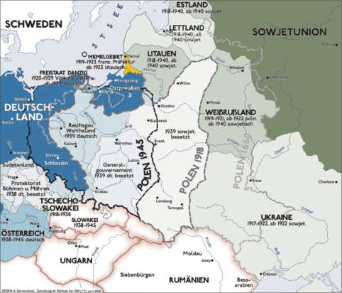 An illustration of the changing borders in Eastern Europe before, during, and after World War II (Map is written in German)
 -
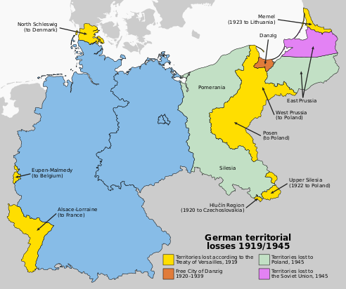 Changes in Germany's borders as a result of both World Wars, with the partition of East Prussia.

جنوب بروسيا الشرقية إلى پولندا
Representatives of the Polish government officially took over the civilian administration of the southern part of East Prussia on 23 May 1945.[15] Subsequently, Polish expatriates from Polish lands annexed by the Soviet Union as well as Ukrainians and Lemkos from southern Poland, expelled in Operation Vistula, were settled in the area, initially organised as the Masurian District, later replaced by the Olsztyn Voivodeship in 1947, with a few counties incorporated into Białystok Voivodeship and to Gdańsk Voivodeship. The latter counted in 1950 689,000 inhabitants, 22.6% of them coming from areas annexed by the Soviet Union, 10% Ukrainians, and 18.5% of them pre-war inhabitants. It was dissolved in 1975 to form three smaller units: a much smaller homonymous Olsztyn Voivodeship, the bulk of Elbląg Voivodeship and a significant part of the Suwałki Voivodeship.
The remaining pre-war population was treated as Germanized Poles and a policy of re-Polonization was pursued throughout the country[16] Most of these "Autochthons" chose to emigrate to West Germany from the 1950s through 1980s (between 1970 and 1988 55,227 persons from Warmia and Masuria moved to Western Germany).[17] Local toponyms were Polonised by the Polish Commission for the Determination of Place Names.[18]
أصل تعداد ما بعد الحرب
During the Polish post-war census of December 1950, data about the pre-war places of residence of the inhabitants as of August 1939 was collected. In case of children born between September 1939 and December 1950, their origin was reported based on the pre-war places of residence of their mothers. Thanks to this data it is possible to reconstruct the pre-war geographical origin of the post-war population. The same area corresponding to pre-war southern parts of East Prussia (which became Polish in 1945) was inhabited in December 1950 by:
| Region (within 1939 borders): | Number | Percent |
|---|---|---|
| Autochthons (1939 DE/FCD citizens) | 134,702 | 15.90% |
| Polish expellees from Kresy (USSR) | 172,480 | 20.36% |
| Poles from abroad except the USSR | 5,734 | 0.68% |
| Resettlers from the City of Warsaw | 22,418 | 2.65% |
| From Warsaw region (Masovia) | 158,953 | 18.76% |
| From Białystok region and Sudovia | 102,634 | 12.11% |
| From pre-war Polish Pomerania | 83,921 | 9.90% |
| Resettlers from Poznań region | 7,371 | 0.87% |
| Katowice region (East Upper Silesia) | 2,536 | 0.30% |
| Resettlers from the City of Łódź | 1,666 | 0.20% |
| Resettlers from Łódź region | 6,919 | 0.82% |
| Resettlers from Kielce region | 20,878 | 2.46% |
| Resettlers from Lublin region | 60,313 | 7.12% |
| Resettlers from Kraków region | 5,515 | 0.65% |
| Resettlers from Rzeszów region | 47,626 | 5.62% |
| place of residence in 1939 unknown | 13,629 | 1.61% |
| Total pop. in December 1950 | 847,295 | 100.00% |
Over 80% of the 1950 inhabitants were new in the region, less than 20% had resided in the province already back in 1939 (so called autochthons, who had German citizenship before World War II and were granted Polish citizenship after 1945). Over 20% of all inhabitants were Poles expelled from areas of Eastern Poland annexed by the USSR. The rest were mostly people from neighbouring areas located right next to East Prussia (almost 44% came from Masovia, Sudovia, Podlachia and pre-war Polish Pomerania) and southern Poland (≈16%).
الجزء الشمالي إلى الاتحاد السوڤيتي


In April 1946, northern East Prussia became an official province of the Russian Soviet Federative Socialist Republic as the "Kyonigsbergskaya Oblast", with the Memel Territory becoming part of the Lithuanian Soviet Socialist Republic. In June 1946 114,070 German and 41,029 Soviet citizens were registered in the Oblast, with an unknown number of disregarded unregistered persons. In July of that year, the historic city of Königsberg was renamed Kaliningrad to honour Mikhail Kalinin and the area named the Kaliningrad Oblast. Between 24 August and 26 October 1948 21 transports with in total 42,094 Germans left the Oblast to the Soviet Occupation Zone (which became East Germany). The last remaining Germans left in November 1949 (1,401 persons) and January 1950 (7 persons).[19]
The Prussian Lithuanians also experienced the same fate.
A similar fate befell the Curonians who lived in the area around the Curonian Lagoon. While many fled from the Red Army during the evacuation of East Prussia, Curonians that remained behind were subsequently expelled by the Soviet Union. Only 219 lived along the Curonian Spit in 1955. Many had German names such as Fritz or Hans, a cause for anti-German discrimination. The Soviet authorities considered the Curonians fascists. Because of this discrimination, many immigrated to West Germany in 1958, where the majority of Curonians now live.
After the expulsion of the German population ethnic Russians, Belarusians, and Ukrainians were settled in the northern part. In the Soviet part of the region, a policy of eliminating all remnants of German history was pursued. All German place names were replaced by new Russian names. The exclave was a military zone, which was closed to foreigners; Soviet citizens could only enter with special permission. In 1967 the remnants of Königsberg Castle were demolished on the orders of Leonid Brezhnev to make way for a new "House of the Soviets".
الوضع الحالي
Although the 1945–1949 expulsion of Germans from the northern part of former East Prussia was often conducted in a violent and aggressive way by Soviet officials, the present Russian inhabitants of the Kaliningrad Oblast have much less animosity towards Germans. German names have been revived in commercial Russian trade and there is sometimes talk of reverting Kaliningrad's name to its historical name of Königsberg. The city centre of Kaliningrad was completely rebuilt, as Royal Air Force bombs in 1944 and the Soviet siege in 1945 had left it in ruins.
Since the dissolution of the Soviet Union in 1991, some German groups have tried to help settle the Volga Germans from eastern parts of European Russia in the Kaliningrad Oblast. This effort was only a minor success, however, as most impoverished Volga Germans preferred to emigrate to the richer Federal Republic of Germany, where they could become German citizens through the right of return.
The Polish part of the region, divided in 1975 to form three units: the Olsztyn Voivodeship, the Elbląg Voivodeship, and the Suwałki Voivodeship, has been reestablished as a single entity in 1999 under the name of Warmian-Masurian Voivodeship, whose borders correspond closely to those of southern East Prussia. Since 2004, Poland and Lithuania have become European Union member states, and both the Polish part of the region as well as the Lithuanian Klaipėda Region, has thereafter become freely accessible by Germans, in line with the free movement of people policy.
الديمغرافيا
البنية العرقية والدينية التاريخيتان

In year 1824, shortly before its merger with West Prussia, the population of East Prussia was 1,080,000 people.[20] Of that number, according to Karl Andree, ethnic Germans were slightly more than half, while 280,000 (≈26%) were ethnically Polish and 200,000 (≈19%) were ethnically Lithuanian.[21] As of year 1819, there were also 20,000 strong ethnic Curonian and Latvian minorities as well as 2,400 Jews, according to Georg Hassel.[22] Similar numbers are given by August von Haxthausen in his 1839 book, with a breakdown by county.[23] However, the majority of East Prussian Polish and Lithuanian inhabitants were Lutherans, not Roman Catholics like their ethnic kinsmen across the border in the Russian Empire. Only in Southern Warmia (German: Ermland) Catholic Poles - so called Warmiaks (not to be confused with predominantly Protestant Masurians) - comprised the majority of population, numbering 26,067 people (≈81%) in county Allenstein (Polish: Olsztyn) in 1837.[23] Another minority in 19th century East Prussia, were ethnically Russian Old Believers, also known as Philipponnen - their main town was Eckersdorf (Wojnowo).[24][25][26]
In year 1817, East Prussia had 796,204 Evangelical Christians, 120,123 Roman Catholics, 864 Mennonites and 2,389 Jews.[27]
Ethnolinguistic composition by district

As of 1905, the province of East Prussia was divided into three government regions, known as Regierungsbezirke. These were the regions of Königsberg, Gumbinnen and Allenstein.
| District (Kreis) | Regierungsbezirk | Population | German | % | Polish | % | Lithuanian | % |
|---|---|---|---|---|---|---|---|---|
| Braunsberg | Königsberg | 54,751 | 54,548 | 99.6% | 140 | 0.3% | 12 | 0.0% |
| Fischhausen | Königsberg | 52,430 | 52,235 | 99.6% | 90 | 0.2% | 43 | 0.1% |
| Friedland | Königsberg | 40,822 | 40,784 | 99.9% | 14 | 0.0% | 5 | 0.0% |
| Gerdauen | Königsberg | 33,983 | 33,778 | 99.4% | 146 | 0.4% | 1 | 0.0% |
| Heiligenbeil | Königsberg | 43,951 | 43,909 | 99.9% | 21 | 0.0% | 2 | 0.0% |
| Heilsberg | Königsberg | 51,690 | 51,473 | 99.6% | 124 | 0.2% | 8 | 0.0% |
| Landkreis Königsberg | Königsberg | 45,486 | 45,342 | 99.7% | 72 | 0.2% | 12 | 0.0% |
| Stadtkreis Königsberg | Königsberg | 223,770 | 221,167 | 98.8% | 594 | 0.3% | 159 | 0.1% |
| Labiau | Königsberg | 51,295 | 45,659 | 89.0% | 27 | 0.1% | 5,293 | 10.3% |
| Memel | Königsberg | 61,018 | 33,508 | 54.9% | 40 | 0.1% | 26,328 | 43.1% |
| Mohrungen | Königsberg | 52,408 | 52,215 | 99.6% | 113 | 0.2% | 2 | 0.0% |
| Preußisch Eylau | Königsberg | 49,465 | 49,325 | 99.7% | 91 | 0.2% | 3 | 0.0% |
| Preußisch Holland | Königsberg | 38,599 | 38,505 | 99.8% | 61 | 0.2% | 4 | 0.0% |
| Rastenburg | Königsberg | 46,985 | 45,998 | 97.9% | 723 | 1.5% | 19 | 0.0% |
| Wehlau | Königsberg | 46,774 | 46,401 | 99.2% | 178 | 0.4% | 81 | 0.2% |
| Total (Königsberg) | Königsberg | 893,427 | 854,847 | 95.7% | 2,434 | 0.3% | 31,972 | 3.6% |
| Angerburg | Gumbinnen | 35,945 | 34,273 | 95.3% | 1,499 | 4.2% | 39 | 0.1% |
| Darkehmen | Gumbinnen | 32,285 | 32,137 | 99.5% | 74 | 0.2% | 17 | 0.1% |
| Goldap | Gumbinnen | 43,829 | 42,891 | 97.9% | 436 | 1.0% | 185 | 0.4% |
| Gumbinnen | Gumbinnen | 50,918 | 50,703 | 99.6% | 21 | 0.0% | 21 | 0.0% |
| Heydekrug | Gumbinnen | 43,268 | 19,124 | 44.2% | 35 | 0.1% | 23,279 | 53.8% |
| Landkreis Insterburg | Gumbinnen | 46,237 | 45,693 | 98.8% | 68 | 0.1% | 311 | 0.7% |
| Stadtkreis Insterburg | Gumbinnen | 28,902 | 28,412 | 98.3% | 166 | 0.6% | 62 | 0.2% |
| Niederung | Gumbinnen | 55,129 | 47,792 | 86.7% | 47 | 0.1% | 6,497 | 11.8% |
| Oletzko | Gumbinnen | 38,536 | 24,575 | 63.8% | 12,451 | 32.3% | 8 | 0.0% |
| Pilkallen | Gumbinnen | 46,230 | 41,982 | 90.8% | 65 | 0.1% | 3,668 | 7.9% |
| Ragnit | Gumbinnen | 54,741 | 45,525 | 83.2% | 80 | 0.1% | 8,394 | 15.3% |
| Stallupönen | Gumbinnen | 43,875 | 43,099 | 98.2% | 90 | 0.2% | 383 | 0.9% |
| Landkreis Tilsit | Gumbinnen | 46,441 | 25,322 | 54.5% | 38 | 0.1% | 20,674 | 44.5% |
| Stadtkreis Tilsit | Gumbinnen | 37,148 | 35,598 | 95.8% | 37 | 0.1% | 1,442 | 3.9% |
| Total (Gumbinnen) | Gumbinnen | 603,484 | 517,126 | 85.7% | 15,107 | 2.5% | 64,980 | 10.8% |
| Allenstein | Allenstein | 85,625 | 45,723 | 53.4% | 38,701 | 45.2% | 21 | 0.0% |
| Johannisburg | Allenstein | 50,452 | 13,651 | 27.1% | 35,433 | 70.2% | 5 | 0.0% |
| Lötzen | Allenstein | 41,609 | 21,997 | 52.9% | 16,877 | 40.6% | 27 | 0.1% |
| Lyck | Allenstein | 55,790 | 23,562 | 42.2% | 30,555 | 54.8% | 2 | 0.0% |
| Neidenburg | Allenstein | 57,325 | 16,304 | 28.4% | 38,690 | 67.5% | 5 | 0.0% |
| Ortelsburg | Allenstein | 69,464 | 17,221 | 24.8% | 50,665 | 72.9% | 58 | 0.1% |
| Osterode | Allenstein | 73,421 | 39,778 | 54.2% | 33,129 | 45.1% | 13 | 0.0% |
| Rößel | Allenstein | 50,390 | 42,555 | 84.5% | 7,383 | 14.7% | 15 | 0.0% |
| Sensburg | Allenstein | 49,187 | 21,960 | 44.6% | 25,381 | 51.6% | 13 | 0.0% |
| Total (Allenstein) | Allenstein | 533,263 | 242,751 | 45.5% | 276,814 | 51.9% | 159 | 0.0% |
| Total (East Prussia) | - | 2,030,174 | 1,614,724 | 79.5% | 294,355 | 14.5% | 97,111 | 4.8% |
الإدارة
The Prussian central government appointed for every province an Oberpräsident ("Upper President") carrying out central prerogatives on the provincial level and supervising the implementation of central policy on the lower levels of administration.
Since 1875, with the strengthening of self-rule, the urban and rural districts (Kreise) within each province (sometimes within each governorate) formed a corporation with common tasks and assets (schools, traffic installations, hospitals, cultural institutions, jails etc.) called the Provinzialverband (provincial association). Initially the assemblies of the urban and rural districts elected representatives for the provincial diets (Provinziallandtage), which were thus indirectly elected. As of 1919 the provincial diets (or as to governorate diets, the so-called Kommunallandtage) were directly elected by the citizens of the provinces (or governorates, respectively). These parliaments legislated within the competences transferred to the provincial associations. The provincial diet of East Prussia elected a provincial executive body (government), the provincial committee (Provinzialausschuss), and a head of province, the Landeshauptmann ("Land Captain"; till the 1880s titled Landdirektor, land director).[29]
Upper Presidents of East Prussia and Prussia
- 1765–1791: Johann Friedrich von Domhardt, president of the Gumbinnen and Königsberg War and Demesnes Chambers
- 1791–1808: Friedrich Leopold von Schrötter, president of the Gumbinnen and Königsberg War and Demesnes Chambers, as of 1795 Minister for East and New East Prussia
- 1808–1814: vacancy?
- 1814–1824: Hans Jakob von Auerswald, upper president of East Prussia
- 1824–1842: Heinrich Theodor von Schön, upper president of Prussia, merged from East and West Prussia, since 1816 already upper president of West Prussia
- 1842–1848: Carl Wilhelm von Bötticher, upper president of Prussia
- 1848–1849: Rudolf von Auerswald, upper president of Prussia
- 1849–1850: Eduard Heinrich von Flottwell (1786–1865), upper president of Prussia
- 1850–1868: Franz August Eichmann, upper president of Prussia
- 1868–1869: vacancy
- 1869–1882: Carl Wilhelm Heinrich Georg von Horn, upper president of Prussia, after 1878 of East Prussia
- 1882–1891: Albrecht Heinrich von Schlieckmann, upper president of East Prussia
- 1891–1895: Count Udo zu Stolberg-Wernigerode, upper president of East Prussia
- 1895–1901: Count Wilhelm von Bismarck-Schönhausen, upper president of East Prussia
- 1901–1903: Hugo Samuel von Richthofen, upper president of East Prussia
- 1903–1907: Count Friedrich von Moltke, upper president of East Prussia
- 1907–1914: Ludwig von Windheim, upper president of East Prussia
- 1914–1916: Adolf Tortilowicz von Batocki-Friebe, upper president of East Prussia
- 1916–1918: Friedrich von Berg, upper president of East Prussia
- 1918–1919: Adolf Tortilowicz von Batocki-Friebe, upper president of East Prussia
- 1919–1920: August Winnig (SPD), upper president of East Prussia
- 1920–1932: Ernst Siehr (DDP), upper president of East Prussia
- 1932–1933: Wilhelm Kutscher (DNVP), upper president of East Prussia
- 1933–1945: Erich Koch (NSDAP), upper president of East Prussia
Elections to the provincial diets
| Parties | % 1921 |
+/- 1921 |
Seats 1921 |
+/- 1921 |
% 1925 |
+/- 1925 |
Seats 1925 |
+/- 1925 |
% 1929 |
+/- 1929 |
Seats 1929 |
+/- 1929 |
% 1933 |
+/- 1933 |
Seats 1933 |
+/- 1933 | |
|---|---|---|---|---|---|---|---|---|---|---|---|---|---|---|---|---|---|
| SPD | 24.1 | 20 | 24.8 | +0.7 (-) | 22 | +2 (-4) | 26 | +1.2 | 23 | +1 | 13.6 | -12.4 | 12 | -11 | |||
| USPD | 6 | +6 | merged in SPD | ||||||||||||||
| DNVP[30] | 13.4 | +13.4 | 11 | +11 | 45.6[31] | 40 | (+4) | 31.2 | (+17.8) | 27 | (+16) | 12.7[30] | -18.5 | 11 | -16 | ||
| DVP | 3.6 | +3.6 | 4 | +4 | 8.7 | (+5.1) | 8 | (+4) | 0 | -8 | |||||||
| BWA | 16 | +16 | 0 | -16 | 0 | 0 | 0 | 0 | |||||||||
| Zentrum | 9.3 | 8 | +8 | 6.9 | -2.4 | 6 | -2 | 8.1 | +1.2 | 7 | +1 | 7 | -1.1 | 7 | 0 | ||
| KPD[32] | 7 | +7 | 6 | +6 | 6.9 | -0.1 | 6 | 0 | 8.6 | +1.7 | 8 | +2 | 6 | -2.6 | 6 | -2 | |
| BWW | 6 | +6 | 0 | -6 | 0 | 0 | 0 | 0 | |||||||||
| Parties | % 1921 |
+/- 1921 |
Seats 1921 |
+/- 1921 |
% 1925 |
+/- 1925 |
Seats 1925 |
+/- 1925 |
% 1929 |
+/- 1929 |
Seats 1929 |
+/- 1929 |
% 1933 |
+/- 1933 |
Seats 1933 |
+/- 1933 | |
| DDP | 5.7 | +5.7 | 6 | +6 | 3.6 | -2.1 | 3 | -3 | 2.8 | -0.8 | 3 | 0 | 0 | -3 | |||
| NSDAP | not run | not run | not run | not run | 4.3 | 4 | +4 | 58.2 | +53,9 | 51 | +47 | ||||||
| LL/WP[33] | 2 | +2 | 4.2 | +4.2 | 4 | +2 | 4 | -1.2 | 4 | 0 | 0 | -4 | |||||
| DFP | not run | not run | not run | not run | 4.2 | +4.2 | 4 | +4 | 0 | -4 | 0 | 0 | |||||
| CSVD | not run | not run | not run | not run | not run | not run | not run | not run | 3 | +3 | 3 | +3 | 0 | -3 | |||
| AuA | not run | not run | not run | not run | 2 | +2 | 0 | -2 | 0 | 0 | |||||||
| FOW | 2 | +2 | 0 | -2 | 0 | 0 | 0 | 0 | |||||||||
| Poles' Party | 1 | +1 | 0 | -1 | 0 | 0 | 0 | 0 | |||||||||
| Others | 2 | +? | 0 | -2 | 0 | 0 | 0 | 0 | |||||||||
| Total 1921 |
85 | Total 1925 |
87 | Total 1929 |
87 | Total 1933 |
87 | ||||||||||
Land Directors and Land Captains of East Prussia
- 1876–1878: Heinrich Edwin Rickert (NLP, later DFP), titled land director
- 1878–1884: Kurt von Saucken-Tarputschen (Fortschritt, later DFP), titled land director
- 1884–1888: Alfred von Gramatzki (DKP), titled land director
- 1888–1896: Klemens von Stockhausen, titled land director
- 1896–1909: Rudolf von Brandt, titled land captain
- 1909–1916: Friedrich von Berg, titled land captain
- 1916–1928: Manfred Graf von Brünneck-Bellschwitz, titled land captain
- 1928–1936: Paul Blunk, titled land captain
- 1936–1941: Helmuth von Wedelstädt (NSDAP), titled land captain
- 1941–1945: vacancy
- 1941–1945: Reinhard Bezzenberger, first land councillor, per pro
المدن والبلدات
انظر أيضاً
- Lithuania Minor
- قائمة مدن وبلدات پروسيا الشرقية
- Drang nach Osten
- East Colonisation
- Kaliningrad Oblast
- Landsmannschaft Ostpreußen
- Masuria
- Teutonic Knights
- Warmia
المصادر
- ^ The Columbia Encyclopedia, Sixth Edition (2008), East Prussia
- ^ Schaitberger, L. "Ostpreußen: The Great Trek". Retrieved 8 December 2016.
- ^ Encyclopædia Britannica: Old-Prussian-language; Gordon, Raymond G., Jr. (ed.): Ethnologue: Languages of the World, 2005, Prussian
- ^ tenn@owlnet.rice.edu. "Sarmatian Review XV.1: Davies". Retrieved 8 December 2016.
- ^ أ ب Andreas Kossert, Ostpreußen. Geschichte und Mythos, 2007 Pantheon Verlag, PDF edition, p. 342. According to Kossert East Prussia lost about 511,000 out of 2,490,000 inhabitants, thereof 311,000 civilians.
- ^ Szkolnictwo polskie w Niemczech 1919-1939, Henryk Chałupczak Wydawnictwo Uniwersytetu Marii Curie-Skłodowskiej,page9 1996
- ^ S. Achremczyk: Warmia, Olsztyn 2000.
- ^ S. Achremczyk: Historia Warmii i Mazur, Olsztyn 1997
- ^ Denny, Isabel (2007). The Fall of Hitler's Fortress City: The Battle for Königsberg, 1945. Havertown: Casemate. p. 256. ISBN 978-1-935149-20-0.
- ^ Rademacher, Michael. "Deutsche Verwaltungsgeschichte Preußen, Provinz Ostpreußen 1871 - 1945". Archived from the original on 30 December 2016. Retrieved 8 December 2016.
- ^ Beevor, Antony, Berlin: The Downfall 1945, Penguin Books (2002). ISBN 0-670-88695-5
- ^ Beevor, Antony, Berlin: The Downfall 1945, chapters 1-8, Penguin Books (2002). ISBN 0-670-88695-5
- ^ Geoffrey K. Roberts, Patricia Hogwood (2013). The Politics Today Companion to West European Politics. Oxford University Press. p. 50. ISBN 9781847790323.; Piotr Stefan Wandycz (1980). The United States and Poland. Harvard University Press. p. 303. ISBN 9780674926851.; Phillip A. Bühler (1990). The Oder-Neisse Line: a reappraisal under international law. East European Monographs. p. 33. ISBN 9780880331746.
- ^ Andreas Kossert, Damals in Ostpreußen, p. 168, München 2008 ISBN 978-3-421-04366-5
- ^ أ ب ت Ther, Philipp; Siljak, Anna (2001). Redrawing nations: ethnic cleansing in East-Central Europe, 1944-1948. Rowman&Littlefield Publishers. p. 109. ISBN 0-7425-1094-8.
- ^ Ethnic Germans in Poland and the Czech Republic:A Comparative Evaluation Archived 3 مارس 2016 at the Wayback Machine by Karl Cordell and Stefan Wolff
- ^ Andreas Kossert, Ostpreußen - Geschichte und Mythos, p.352, ISBN 3-88680-808-4
- ^ The Polish toponymic guidelines[dead link] (p.9)
- ^ Andreas Kossert, Damals in Ostpreußen, pp. 179–183, München 2008 ISBN 978-3-421-04366-5
- ^ Plater, Stanisław (1825). Jeografia wschodniéy części Europy czyli Opis krajów przez wielorakie narody słowiańskie zamieszkanych: obejmujący Prussy, Xsięztwo Poznańskie, Szląsk Pruski, Gallicyą, Rzeczpospolitę Krakowską, Krolestwo Polskie i Litwę (in البولندية). Wrocław: u Wilhelma Bogumiła Korna. p. 17.
- ^ Andree, Karl (1831). Polen: in geographischer, geschichtlicher und culturhistorischer Hinsicht (in الألمانية). Verlag von Ludwig Schumann. p. 218.
- ^ Hassel, Georg (1823). Statistischer Umriß der sämmtlichen europäischen und der vornehmsten außereuropäischen Staaten, in Hinsicht ihrer Entwickelung, Größe, Volksmenge, Finanz- und Militärverfassung, tabellarisch dargestellt; Erster Heft: Welcher die beiden großen Mächte Österreich und Preußen und den Deutschen Staatenbund darstellt (in الألمانية). Verlag des Geographischen Instituts Weimar. p. 41.
- ^ أ ب Haxthausen, August (1839). Die Ländliche Verfassung in den Einzelnen Provinzen der Preussischen Monarchie (in الألمانية). pp. 75–91.
- ^ "Monastery of the Dormition of the Mother of God in Wojnowo (Eckersdorf)". wojnowo.net.
- ^ Tetzner, Franz (1902). Die Slawen in Deutschland: beiträge zur volkskunde der Preussen, Litauer und Letten, der Masuren und Philipponen, der Tschechen, Mährer und Sorben, Polaben und Slowinzen, Kaschuben und Polen. Braunschweig: Verlag von F. Vieweg. pp. 212–248.
- ^ "Old Believers in Poland - historical and cultural information". Poland's Linguistic Heritage. Archived from the original on 23 December 2018. Retrieved 23 December 2018.
- ^ Hoffmann, Johann Gottfried (1818). Übersicht der Bodenfläche und Bevölkerung des Preußischen Staates : aus den für das Jahr 1817 mtlich eingezogenen Nachrichten. Berlin: Decker. p. 51.
- ^ Belzyt, Leszek (1998). Sprachliche Minderheiten im preussischen Staat: 1815 - 1914 ; die preußische Sprachenstatistik in Bearbeitung und Kommentar. Marburg: Herder-Inst. ISBN 978-3-87969-267-5.[dead link]
- ^ In some Prussian provinces the same office continued to be called Landesdirektor also thereafter. Cf. article: "Landesdirektor", in: Der Große Brockhaus: Handbuch des Wissens in zwanzig Bänden: 21 vols.; Leipzig: Brockhaus, 151928–1935; vol. 11 (1932), p. 71.
- ^ أ ب In 1933 the DNVP ran under the list KFSWR, also including Der Stahlhelm and the LB.
- ^ DVP and DNVP formed the united list called Prussian Block (PB, Preußemblock).
- ^ In 1921 the party was named United Communist Party of Germany, VKPD.
- ^ In 1921 the Landliste (LL, Rural List) gained two seats, in 1926 the LL formed a united list with the WP and the East Prussian Farmers' Federation (OBB), in 1929 they all ran as part of the WP.
المراجع
؛ منشورات بالإنگليزية
- Baedeker, Karl, Northern Germany, 14th revised edition, London, 1904.
- Beevor, Antony (2002). "chapters 1-8". Berlin: The Downfall 1945. Penguin Books. ISBN 0-670-88695-5. (on the years 1944/45)
- Alfred-Maurice de Zayas, " Nemesis at Potsdam". London, 1977. ISBN 0-8032-4910-1.
- Alfred-Maurice de Zayas, A Terrible Revenge: The Ethnic Cleansing of the East European Germans, 1944-1950, 1994, ISBN 0-312-12159-8
- Dickie, Reverend J.F., with E.Compton, Germany, A & C Black, London, 1912.
- von Treitschke, Heinrich, History of Germany - vol.1: The Wars of Emancipation, (translated by E & C Paul), Allen & Unwin, London, 1915.
- Powell, E. Alexander, Embattled Borders, London, 1928.
- Prausser, Steffen and Rees, Arfon: The Expulsion of the "German" Communities from Eastern Europe at the End of the Second World War. Florence, Italy, European University Institute, 2004.
- Naimark, Norman: Fires of Hatred. Ethnic Cleansing in Twentieth-Century Europe. Cambridge, Harvard University Press, 2001.
- Steed, Henry Wickham, Vital Peace - A Study of Risks, Constable & Co., London, 1936.
- Newman, Bernard, Danger Spots of Europe, London, 1938.
- Wieck, Michael: A Childhood Under Hitler and Stalin: Memoirs of a "Certified Jew," University of Wisconsin Press, 2003, ISBN 0-299-18544-3.
- Woodward, E.L., Butler, Rohan; Medlicott, W.N., Dakin, Douglas, & Lambert, M.E., et al. (editors), Documents on British Foreign Policy 1919-1939, Three Series, Her Majesty's Stationery Office (HMSO), London, numerous volumes published over 25 years. Cover the Versailles Treaty including all secret meetings; plebiscites and all other problems in Europe; includes all diplomatic correspondence from all states.
- Previté-Orton, C.W., Professor, The Shorter Cambridge Medieval History, Cambridge University Press, 1952 (2 volumes).
- Balfour, Michael, and John Mair, Four-Power Control in Germany and Austria 1945-1946, Oxford University Press, 1956.
- Kopelev, Lev, To Be Preserved Forever, ("Хранить вечно"), 1976.
- Koch, H.W., Professor, A History of Prussia, Longman, London, 1978/1984, (P/B), ISBN 0-582-48190-2
- Koch, H.W., Professor, A Constitutional History of Germany in the 19th and 20th Centuries, Longman, London, 1984, (P/B), ISBN 0-582-49182-7
- MacDonogh, Giles, Prussia, Sinclair-Stevenson, London, 1994, ISBN 1-85619-267-9
- Nitsch, Gunter, Weeds Like Us, AuthorHouse, 2006, ISBN 9781425967550
؛ منشورات بالألمانية
- B. Schumacher: Geschichte Ost- und Westpreussens, Würzburg 1959
- Boockmann, Hartmut: Ostpreußen und Westpreußen (= Deutsche Geschichte im Osten Europas). Siedler, Berlin 1992, ISBN 3-88680-212-4
- Buxa, Werner and Hans-Ulrich Stamm: Bilder aus Ostpreußen
- Dönhoff, Marion Gräfin v. :Namen die keiner mehr nennt - Ostpreußen, Menschen und Geschichte
- Dönhoff, Marion Gräfin v.: Kindheit in Ostpreussen
- Falk, Lucy: Ich Blieb in Königsberg. Tagebuchblätter aus dunklen Nachkriegsjahren
- Kibelka, Ruth: Ostpreußens Schicksaljahre, 1945-1948
- Bernd, Martin (1998). Masuren, Mythos und Geschichte. Karlsruhe: Evangelische Akademie Baden. ISBN 8385135936.
- Nitsch, Gunter: "Eine lange Flucht aus Ostpreußen", Ellert & Richter Verlag, 2011, ISBN 978-3-8319-0438-9
- Wieck, Michael: Zeugnis vom Untergang Königsbergs: Ein "Geltungsjude" berichtet, Heidelberger Verlaganstalt, 1990, 1993, ISBN 3-89426-059-9.
؛ منشورات بالفرنسية
- Pierre Benoît, Axelle
- Georges Blond, L'Agonie de l'Allemagne
- Michel Tournier, Le Roi des aulnes
- Publications in Polish
- K. Piwarski (1946). Dzieje Prus Wschodnich w czasach nowożytnych. Gdańsk.
{{cite book}}: CS1 maint: location missing publisher (link) - Gerard Labuda, ed. (1969–2003). "Historia Pomorza", vol. I-IV. Poznań.
{{cite book}}: CS1 maint: date format (link) CS1 maint: location missing publisher (link) - collective work (1958–61). "Szkice z dziejów Pomorza", vol. 1-3. Warszawa.
{{cite book}}: CS1 maint: date format (link) CS1 maint: location missing publisher (link) - Andreas Kossert (2009). PRUSY WSCHODNIE, Historia i mit. Warszawa. ISBN 978-83-7383-354-8.
{{cite book}}: CS1 maint: location missing publisher (link)
وصلات خارجية
- Brandenburg Prince-Electors co-inheritors 1568, co-regent 1577
- East Prussia FAQ
- East and West Prussia Gazetteer
- Provinz Ostpreußen (بالألمانية)
- Ostpreußen.net (بالألمانية)
- Ostpreußen Info - East Prussia Information (بالألمانية)
- East- and West Prussia in Photos
- Spuren der Vergangenheit / Следы Пρошлого (Traces of the past) This site by W.A. Milowskij, a Kaliningrad resident, contains hundreds of interesting photos, often with text explanations, of architectural and infrastructural artifacts of the territory's long German past. (بالألمانية) (بالروسية)
- German Empire: Province of East Prussia (بالألمانية)
- Britannica 2007 article
- Growing up in East Prussia An oral history project, documenting the German history of East Prussia with memories and reports by contemporary witnesses (بالألمانية) (Polish)
- Articles with dead external links from August 2019
- CS1 البولندية-language sources (pl)
- CS1 الألمانية-language sources (de)
- Articles with dead external links from May 2023
- Short description is different from Wikidata
- Articles with hatnote templates targeting a nonexistent page
- Missing redirects
- Articles containing ألمانية-language text
- Former country articles requiring maintenance
- Pages using Lang-xx templates
- Articles containing پولندية-language text
- Articles containing لتوانية-language text
- Articles containing روسية-language text
- Articles with unsourced statements from February 2009
- Articles with unsourced statements from April 2008
- CS1 maint: location missing publisher
- CS1 maint: date format
- CS1: abbreviated year range
- پروسيا الشرقية
- تقسيمات پروسيا
- Exclaves
- مملكة پروسيا
- مناطق أوروپا
- مناطق تاريخية
- تقسيم (سياسة)
- 1945 disestablishments in Germany
- Former eastern territories of Germany