مازوريا
مازوريا
Mazury Masuria | |
|---|---|
منطقة | |
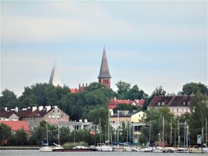
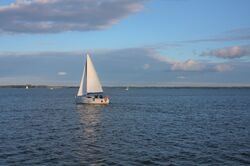 قارب شراعي في Lake Niegocin | |
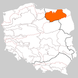 Masuria occupies much of the Masurian Lake District | |
| البلد | پولندا |
| المنطقة | الڤويڤودية الڤارمية-المازورية |
| المساحة | |
| • الإجمالي | 10٬000 كم² (4٬000 ميل²) |
| التعداد | |
| • الإجمالي | 500٬000 |
| • الكثافة | 50/km2 (130/sq mi) |
| منطقة التوقيت | UTC+1 (CET) |
| • الصيف (التوقيت الصيفي) | UTC+2 (CEST) |
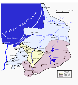
مازوريا (قالب:Audio-pl, ألمانية: Masuren؛ بالمازورية: Mazurÿ ؛ إنگليزية: Masuria) هي منطقة تاريخية في شمال شرق پولندا، تشتهر بوجود 2,000 بحيرة فيها.[1] تحتل مازوريا معظم منطقة البحيرات المازورية. إدارياً، هي جزء من الڤويڤودية الڤارمية-المازورية (منطقة ادارية/مقاطعة). أكبر مدنها، وكثيراً ما تُعتبر عاصمتها، هي Ełk (Elk). تغطي المنطقة نحو 10,000 كم² ويسكنها نحو 500,000 نسمة.
التاريخ
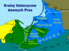
القبائل الجرمانية الشرقية
The first known people in today's Mazuria were East Germanic tribes, such as the Scirii. [2] Finds from gravesites around Soldau and Neidenburg have become known as the Soldau-Neidenburg group of East Germanic culture.[3]
الپروس القدماء
Before the 13th century, the territory was inhabited by the Old Prussians also called Baltic Prussians, a Baltic ethnic group that lived in Prussia (the area of the southeastern coastal region of the Baltic Sea neighbouring of the Baltic Sea around the Vistula Lagoon and the Curonian Lagoon). The territory later called Masuria was then known as Galindia and was probably a peripheral, deeply forested and lightly populated area. Its inhabitants spoke a language now known as Old Prussian and had their own mythology. Although a 19th-century German political entity bore their name, they were not Germans. They were converted to Roman Catholicism in the 13th century, after conquest by the Knights of the Teutonic Order.
دوقية پروسيا
After the death of Albert Frederick, Duke of Prussia in 1618, his son-in-law John Sigismund, Margrave of Brandenburg, inherited the duchy (including Masuria), combining the two territories under a single dynasty and forming Brandenburg-Prussia. The Treaty of Wehlau revoked the sovereignty of the King of Poland in 1657.
مملكة پروسيا
البنية العرقية-اللغوية
Mother tongue of the inhabitants of Masuria, by county, during the first half of the 19th century:
| County (German name) | Year | Polish-speakers | % | German-speakers | % | Lithuanian-speakers | % | Total population |
|---|---|---|---|---|---|---|---|---|
| Gołdap (Goldap) | 1825 | 3940 | 16% | 17412 | 70% | 3559 | 14% | 24911 |
| Olecko (Oletzko) | 1832 | 23302 | 84% | 4328 | 16% | 22 | 0% | 27652 |
| Ełk (Lyck) | 1832 | 29246 | 90% | 3413 | 10% | 4 | 0% | 32663 |
| Węgorzewo (Angerburg) | 1825 | 12535 | 52% | 11756 | 48% | 60 | 0% | 24351 |
| Giżycko (Lötzen) | 1832 | 20434 | 89% | 2528 | 11% | 25 | 0% | 22987 |
| Pisz (Johannisburg) | 1825 | 28552 | 93% | 2146 | 7% | 0 | 0% | 30698 |
| Mrągowo (Sensburg) | 1825 | 22391 | 86% | 3769 | 14% | 5 | 0% | 26165 |
| Szczytno (Ortelsburg) | 1825 | 34928 | 92% | 3100 | 8% | 0 | 0% | 38028 |
| Nidzica (Neidenburg) | 1825 | 27467 | 93% | 2149 | 7% | 1 | 0% | 29617 |
| Ostróda (Osterode) | 1828 | 23577 | 72% | 9268 | 28% | 0 | 0% | 32845 |
| TOTAL | 1825/32 | 226,372 | 78% | 59,869 | 21% | 3,676 | 1% | 289,917 |
الامبراطورية الألمانية

مازوريا الپولندية — مقاطعة Działdowo
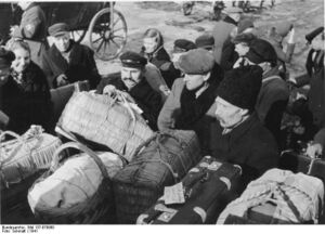
مازوريا بعد الحرب العالمية الثانية

According to the Masurian Institute the Masurian members of resistance against Nazi Germany who survived the war, became active in 1945 in the region, working in Olsztyn in cooperation with new state authorities in administration, education and cultural affairs.[8] Historic Polish names for most of towns of Masuria were restored, but for some places new names were determined even if there were historic Polish names.
البسيطة

Masuria and the Masurian Lake District are known in Polish as Kraina Tysiąca Jezior and in German as Land der Tausend Seen, meaning "land of a thousand lakes." These lakes were ground out of the land by glaciers during the Pleistocene ice age around 14,000 - 15,000 years ago, when ice covered northeastern Europe. From that period originates the horn of a reindeer found in the vicinity of Giżycko.[9] By 10,000 BC this ice started to melt. Great geological changes took place and even in the last 500 years the maps showing the lagoons and peninsulas on the Baltic Sea have greatly altered in appearance. More than in other parts of northern Poland, such as from Pomerania (from the River Oder to the River Vistula), this continuous stretch of lakes is popular among tourists. The terrain is rather hilly, with connecting lakes, rivers and streams. Forests account for about 30% of the area.[10][11] The northern part of Masuria is covered mostly by the broadleaved forest, while the southern part is dominated by pine and mixed forests.[12][13]
Two largest lakes of Poland, Śniardwy and Mamry, are located in Masuria.
البلدات الرئيسية
أشخاص بارزون من مازوريا
- Richard Altmann (1852–1900), pathologist
- Leszek Błażyński (1949–1992), boxer
- Kurt Blumenfeld (1884–1963), politician
- Abraham Calovius (1612–1686), Lutheran theologian
- Roman Czepe (born 1956), politician
- Lucas David (1503–1583), historian
- Ferdinand Gregorovius (1821–1891), historian
- Lothar Gall (born 1936) historian
- Gustaw Gizewiusz (1810–1848), Protestant pastor, supporter of Polish language teaching and resistance against Germanisation
- Georg Andreas Helwing (1666–1748), botanist
- Paul Hensel (1867–1944), politician
- Andreas Hillgruber (1925–1989), historian
- Wojciech Kętrzyński (1838–1918), activist and historian
- Hans Hellmut Kirst (1914–1989), author
- Georg Klebs (1857–1913), botanist
- Walter Kollo (1878–1940), composer
- Horst Kopkow (1910–1996), spy
- Udo Lattek (born 1935), football coach
- Siegfried Lenz (1926-2014), author
- Wolf Lepenies (born 1941), political scientist
- Johannes von Leysen (1310–1388), founder and first mayor of Allenstein
- Albert Lieven (1906–1971), actor
- Krzysztof Celestyn Mrongovius (1764–1855), Protestant pastor and philosopher
- Celestyn Myślenta (1588–1653), Lutheran theologian and rector of the University of Königsberg
- Rodolphe Radau (1835–1911), astronomer
- Karl Bogislaus Reichert (1811–1883), anatomist
- Nicholas von Renys (1360-1411), knight
- Fritz Richard Schaudinn (1871–1906), zoologist
- Paweł Sobolewski (born 1979), footballer
- Helmuth Stieff (1901–1944), general
- Bethel Henry Strousberg (1823–1884), industrialist
- Arno Surminski (born 1934), writer
- Kurt Symanzik (1923–1983), physicist
- August Trunz (1875–1963), founder of the Prussica-Sammlung Trunz
- Ernst Wiechert (1887–1950), poet and writer
- Wilhelm Wien (1864–1928), physicist, Nobel Prize winner
انظر أيضاً
الهامش
- ^ It was a finalist in the Internet-based poll New7Wonders of Nature
- ^ Reinhard Pohanka (2014). Die Völkerwanderung (in الألمانية). marixverlag.
- ^ "Zur Geschichte des Kreises Neidenburg". Retrieved 2020-10-11.
- ^ Christofer Herrmann: Warmia i Mazury : przewodnik po zabytkach sztuki. Bartąg: Wydawnictwo Artes, 2008. ISBN 978-83-61049-24-1. p. 36
- ^ von Haxthausen, August (1839). Die ländliche verfassung in den einzelnen provinzen der Preussischen Monarchie (in الألمانية). Königsberg: Gebrüder Borntraeger Verlagsbuchhandlung. pp. 78–81.
- ^ Jasiński, Grzegorz (2009). "Statystyki językowe powiatów mazurskich z pierwszej połowy XIX wieku (do 1862 roku)" (PDF). Komunikaty Mazursko-Warmińskie (in البولندية). 1: 97–130 – via BazHum.
- ^ Belzyt, Leszek (1996). "Zur Frage des nationalen Bewußtseins der Masuren im 19. und 20. Jahrhundert (auf der Basis statistischer Angaben)". Zeitschrift für Ostmitteleuropa-Forschung (in الألمانية). Bd. 45, Nr. 1: 35–71. Archived from the original on 2019-10-03. Retrieved 2019-10-03 – via zfo-online.
- ^ خطأ استشهاد: وسم
<ref>غير صحيح؛ لا نص تم توفيره للمراجع المسماةO nas - ^ (in پولندية) Krajobraz kulturowy powiatu gołdapskiego, at www.dkgoldap.fr.pl Archived 2010-06-01 at the Wayback Machine
- ^ (in پولندية) Mazury, at www.strefamazury.pl Archived 2010-07-30 at the Wayback Machine
- ^ (in پولندية) Charakterystyka Pojezierza Mazurskiego, at www.bryk.pl
- ^ "Download Limit Exceeded". CiteSeerX 10.1.1.856.8111.
{{cite journal}}: Cite journal requires|journal=(help) - ^ "Masuria - Krutyn - Boat and canoeing trips on the Krutynia River". www.e-masuria.com. Retrieved 14 August 2018.
المراجع
- (in پولندية) Mazury Entry on the region in Polish PWN Encyclopedia.
- Martin, Bernd (1998). Masuren, Mythos und Geschichte (in الألمانية). Karlsruhe: Ewangelische Akademie Baden. ISBN 3-87210-122-6. Archived from the original on 2006-06-28.
- Kruk, Erwin (2003). Warmia i Mazury (in البولندية). Wrocław: Wydawnictwo Dolnośląskie. ISBN 83-7384-028-1.
- Kossert, Andreas (2006). Masuren. Ostpreußens vergessener Süden (in الألمانية). Pantheon. ISBN 3-570-55006-0.
- Kossert, Andreas (2005). Ostpreussen, Geschichte und Mythos (in الألمانية). Siedler. ISBN 3-88680-808-4.
- Kossert, Andreas (2004). Mazury, Zapomniane południe Prus Wschodnich (in البولندية). ISBN 83-7383-067-7.
- Clark, Christopher (2006). Iron Kingdom: The Rise and Downfall of Prussia 1600–1947. Cambridge: Belknap Press of Harvard. pp. 776. ISBN 0-674-02385-4.
وصلات خارجية
- Tourist information (Polish)
- Mazury (Polish)
- Mazury (Polish)
- Masuren Archived 2007-04-05 at the Wayback Machine (German)
- Natural tourism (birdwatching) in NE Poland
- Topographical maps 1:50 000
- Mazury - Poland - canoeing information (Polish)
- Masuren - Poland - canoeing information (German)
- Masuren - canoeing (German)
- Masuria - Poland - canoeing information (English)
- Mazury (Polish)
- CS1 الألمانية-language sources (de)
- CS1 البولندية-language sources (pl)
- Articles with پولندية-language sources (pl)
- Pages using gadget WikiMiniAtlas
- Short description is different from Wikidata
- Articles with hatnote templates targeting a nonexistent page
- Missing redirects
- Pages using infobox settlement with no coordinates
- Articles containing ألمانية-language text
- Pages using Lang-xx templates
- Articles containing إنگليزية-language text
- Coordinates on Wikidata
- مناطق پولندا
- جغرافيا الڤويڤودية الڤارمية-المازورية
- مناطق طبيعية

