المحيط الهادي
| المحيط الهادي Pacific Ocean | |
|---|---|
 | |
| الإحداثيات | 0°N 160°W / 0°N 160°W |
| مساحة السطح | 165،250،000 km2 (63،800،000 sq mi) |
| متوسط العمق | 4،280 m (14،040 ft) |
| أقصى عمق | 10،911 m (35،797 ft) |
| حجم المياه | 710،000،000 km3 (170،000،000 cu mi) |
| الجزر | قائمة الجزر |
| التجمعات السكنية | أكاپولكو، أنادير، أنكوردج، آپيا، أوكلاند, بريزبين, بويناڤنتورا، كالاو، كرايست تشرش, كونسپسيون، كورنتو، دنيدن، Esmeraldas, گواياكيل، هونولولو، Hualien City، كيلونگ، جاياپورا، ليما, لوس أنجلس، ماتشالا، مگدان, مكسر، مانتا، مازاتلان, ملبورن، مدينة تايپـِيْ الجديدة، نوميا، أوساكا، مدينة پنما، پاپيتى، Puerto San José, منطقة خليج سان فرانسيسكو، سان دييگو، سنداي، شيزوؤكا، سورسوگون، سوڤا، سيدني، تانداگ، تيهوانا، طوكيو، ڤالپارايسو، ڤانكوڤر، ڤكتوريا، ڤلاديڤوستوك، ولنگتون، فانيارِيْ، يوكوهاما، يوكوسوكا |
 Interactive map of المحيط الهادي Pacific Ocean | |
   |
| محيطات العالم |
|---|
|
تقسيمات المحيطات الخمسة: تقسيمات أخرى: البحار الهامشية |
المحيط الهادي أو المحيط الهادئ، هو أكبر وأعمق مسطح مائي على ظهر الأرض. تعادل مساحته ثلث مساحة سطح الأرض (179.7 مليون كم²)، وحجمه 674 مليون كم³. يمتد نحو 15500 كم ما بين بحر برينگ شمالاً وهامش القارة القطبية الجنوبية الجليدي عند بحر روس جنوباً، كما تقدر المسافة ما بين شواطئه الشرقية عند كولومبيا وپيرو وشواطئه الغربية الإندونيسية عند خط عرض 5 ْ شمالاً بنحو 19800كم.[1]
يغطي المحيط الهادئ نحو نصف مساحة جميع محيطات العالم الأخرى وثلث سطح الأرض، فهو يمتد من القطب المتجمد الجنوبي، ويرتطم بشواطئ الجزر الدافئة في المنطقة الحارة، وتصل مياهه إلى سواحل جميع القارات ماعدا قارتي إفريقيا وأوروبا.
وعندما أشرف المكتشف البرتغالي فرديناند ماجلان على هذا المحيط الكبير، أطلق عليه اسم المحيط الباسفيكي أي الهادئ. وقد أبحر فيه ماجلان تدفعه رياح خفيفة لعدة أسابيع، شاهد خلالها الأسماك الطائرة والدّلافين تتراقص في مياهه الهادئة الدافئة. غير أن هذا المحيط الكبير ليس بالهادئ دائمًا، إذ من الممكن أن يثور ثورة شديدة فتهب من أرجائه الفسيحة أشد العواصف دمارًا على سطح الأرض. فأعاصير التايفون التي تمرُّ فيه تدمر أساطيل السفن وتسوي مدن الجزر بالأرض، كما تؤدي الزلازل، وثورانات البراكين تحت الأرض، إلى حدوث الموجات البحرية الزلزالية، أو الموجات المدية وأحيانًا يبلغ ارتفاع هذه الموجات 30م، وتغمر الجزر التي تعترض سبيلها تمامًا.
وتوجد في المحيط الهادئ، آلاف الجزر، وبعضها قمم جبال بركانية تبرز من قاع البحر، ويتكوَّن بعضها الآخرُ من الشعاب المرجانية، التي يرتكز الكثير منها على قمم تحت الماء. وتنتشر مئات الجزر الصغيرة المتفرقة في المنطقتين؛ الوسطى والجنوبية من المحيط الهادئ. وتقع مثل هذه البلاد التي تتألف من عدد من الجزر مثل: اليابان والفلبين بالقرب من سواحل آسيا وأستراليا. ويوجد عدد قليل من الجزر شرقي وجنوبي المحيط الهادئ.
التسمية
 |
يعني في اللاتينية Mare Pacificum أي بحر السلام أو الهدوء Peacefull Sea. أعطاه هذا الاسم الرحالة البرتغالي فرديناند ماجلان على ضوء رحلاته الاستكشافية ما بينمضيق ماجلان والفلپين. يعد أكبر وأوسع مسطح مائي على وجه الأرض.
التاريخ
قبل التاريخ
Across the continents of Asia, Australia and the Americas, more than 25,000 islands, large and small, rise above the surface of the Pacific Ocean. Multiple islands were the shells of erstwhile active volcanoes, that have lain dormant for thousands of years. Close to the equator through vast areas of blue ocean are a dot of atolls that have over intervals of time been formed by seamounts as a result of tiny coral islands strung in a ring within surroundings of a central lagoon.
الهجرات المبكرة

Important human migrations occurred in the Pacific in prehistoric times. Modern humans first reached the western Pacific in the Paleolithic, at around 60,000 to 70,000 years ago. Originating from a southern coastal human migration out of Africa, they reached East Asia, Mainland Southeast Asia, the Philippines, New Guinea, and then Australia by making the sea crossing of at least 80 كيلومتر (50 mi) between Sundaland and Sahul. It is not known with any certainty what level of maritime technology was used by these groups – the presumption is that they used large bamboo rafts which may have been equipped with some sort of sail. The reduction in favourable winds for a crossing to Sahull after 58,000 B.P. fits with the dating of the settlement of Australia, with no later migrations in the prehistoric period. The seafaring abilities of pre-Austronesian residents of Island South-east Asia are confirmed by the settlement of Buka by 32,000 B.P. and Manus by 25,000 B.P. Journeys of 180 كيلومتر (110 mi) and 230 كيلومتر (140 mi) are involved, respectively.[2]
The descendants of these migrations today are the East Asian peoples, the Negritos, Melanesians, and Indigenous Australians). Their populations in maritime Southeast Asia, coastal New Guinea, and Island Melanesia later intermarried with the incoming Austronesian settlers from Taiwan and the northern Philippines, but also earlier groups associated with Austroasiatic-speakers, resulting in the modern peoples of Island Southeast Asia and Oceania.[3][4]

A later seaborne migration is the Neolithic Austronesian expansion of the Austronesian peoples. Austronesians originated from the island of Taiwan c. 3000-1500 BCE. They are associated with distinctive maritime sailing technologies (notably outrigger boats, catamarans, lashed-lug boats, and the crab claw sail) – it is likely that the progressive development of these technologies were related to the later steps of settlement into Near and Remote Oceania. Starting at around 2200 BCE, Austronesians sailed southwards to settle the Philippines. From, probably, the Bismarck Archipelago they crossed the western Pacific to reach the Marianas Islands by 1500 BCE,[5] as well as Palau and Yap by 1000 BCE. They were the first humans to reach Remote Oceania, and the first to cross vast distances of open water. They also continued spreading southwards and settling the rest of Maritime Southeast Asia, reaching Indonesia and Malaysia by 1500 BCE, and further west to Madagascar and the Comoros in the Indian Ocean by around 500 CE.[6][7][8] More recently, it is suggested that Austronesians expanded already earlier, arriving in the Philippines already in 7000 BCE. Additional earlier migrations into Insular Southeast Asia, associated with Austroasiatic-speakers from Mainland Southeast Asia, are estimated to have taken place already in 15000 BCE.[9]
At around 1300 to 1200 BCE, a branch of the Austronesian migrations known as the Lapita culture reached the Bismarck Archipelago, the Solomon Islands, Vanuatu, Fiji, and New Caledonia. From there, they settled Tonga and Samoa by 900 to 800 BCE. Some also back-migrated northwards in 200 BCE to settle the islands of eastern Micronesia (including the Carolines, the Marshall Islands, and Kiribati), mixing with earlier Austronesian migrations in the region. This remained the furthest extent of the Austronesian expansion into Polynesia until around 700 CE when there was another surge of island exploration. They reached the Cook Islands, Tahiti, and the Marquesas by 700 CE; Hawaiʻi by 900 CE; Rapa Nui by 1000 CE; and finally New Zealand by 1200 CE.[7][10][11] Austronesians may have also reached as far as the Americas, although evidence for this remains inconclusive.[12][13]
الاستكشاف الأوروبي
The first contact of European navigators with the western edge of the Pacific Ocean was made by the Portuguese expeditions of António de Abreu and Francisco Serrão, via the Lesser Sunda Islands, to the Maluku Islands, in 1512,[14][15] and with Jorge Álvares's expedition to southern China in 1513,[16] both ordered by Afonso de Albuquerque from Malacca.
The eastern side of the ocean was encountered by Spanish explorer Vasco Núñez de Balboa in 1513 after his expedition crossed the Isthmus of Panama and reached a new ocean.[17] He named it Mar del Sur (literally, "Sea of the South" or "South Sea") because the ocean was to the south of the coast of the isthmus where he first observed the Pacific.

In 1520, navigator Ferdinand Magellan and his crew were the first to cross the Pacific in recorded history. They were part of a Spanish expedition to the Spice Islands that would eventually result in the first world circumnavigation. Magellan called the ocean Pacífico (or "Pacific" meaning, "peaceful") because, after sailing through the stormy seas off Cape Horn, the expedition found calm waters. The ocean was often called the Sea of Magellan in his honor until the eighteenth century.[18] Magellan stopped at one uninhabited Pacific island before stopping at Guam in March 1521.[19] Although Magellan himself died in the Philippines in 1521, Spanish navigator Juan Sebastián Elcano led the remains of the expedition back to Spain across the Indian Ocean and round the Cape of Good Hope, completing the first world circumnavigation in 1522.[20] Sailing around and east of the Moluccas, between 1525 and 1527, Portuguese expeditions encountered the Caroline Islands,[21] the Aru Islands,[22] and Papua New Guinea.[23] In 1542–43 the Portuguese also reached Japan.[24]
In 1564, five Spanish ships carrying 379 soldiers crossed the ocean from Mexico led by Miguel López de Legazpi, and colonized the Philippines and Mariana Islands.[25] For the remainder of the 16th century, Spain maintained military and mercantile control, with ships sailing from Mexico and Peru across the Pacific Ocean to the Philippines via Guam, and establishing the Spanish East Indies. The Manila galleons operated for two and a half centuries, linking Manila and Acapulco, in one of the longest trade routes in history. Spanish expeditions also arrived at Tuvalu, the Marquesas, the Cook Islands, the Solomon Islands, and the Admiralty Islands in the South Pacific.[26]

Later, in the quest for Terra Australis ("the [great] Southern Land"), Spanish explorations in the 17th century, such as the expedition led by the Portuguese navigator Pedro Fernandes de Queirós, arrived at the Pitcairn and Vanuatu archipelagos, and sailed the Torres Strait between Australia and New Guinea, named after navigator Luís Vaz de Torres. Dutch explorers, sailing around southern Africa, also engaged in exploration and trade; Willem Janszoon, made the first completely documented European landing in Australia (1606), in Cape York Peninsula,[27] and Abel Janszoon Tasman circumnavigated and landed on parts of the Australian continental coast and arrived at Tasmania and New Zealand in 1642.[28]
In the 16th and 17th centuries, Spain considered the Pacific Ocean a mare clausum—a sea closed to other naval powers. As the only known entrance from the Atlantic, the Strait of Magellan was at times patrolled by fleets sent to prevent the entrance of non-Spanish ships. On the western side of the Pacific Ocean the Dutch threatened the Spanish Philippines.[29]
The 18th century marked the beginning of major exploration by the Russians in Alaska and the Aleutian Islands, such as the First Kamchatka expedition and the Great Northern Expedition, led by the Danish Russian navy officer Vitus Bering. Spain also sent expeditions to the Pacific Northwest, reaching Vancouver Island in southern Canada, and Alaska. The French explored and colonized Polynesia, and the British made three voyages with James Cook to the South Pacific and Australia, Hawaii, and the North American Pacific Northwest. In 1768, Pierre-Antoine Véron, a young astronomer accompanying Louis Antoine de Bougainville on his voyage of exploration, established the width of the Pacific with precision for the first time in history.[30] One of the earliest voyages of scientific exploration was organized by Spain in the Malaspina Expedition of 1789–1794. It sailed vast areas of the Pacific, from Cape Horn to Alaska, Guam and the Philippines, New Zealand, Australia, and the South Pacific.[26]
-
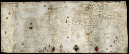 Made in 1529, the Diogo Ribeiro map was the first to show the Pacific at about its proper size
 -
 Map of the Pacific Ocean during European Exploration, circa 1754.
 -
![Maris Pacifici by Ortelius (1589). One of the first printed maps to show the Pacific Ocean[31]](/w/images/thumb/4/4e/Ortelius_-_Maris_Pacifici_1589.jpg/260px-Ortelius_-_Maris_Pacifici_1589.jpg)
-
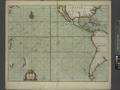 Map of the Pacific Ocean during European Exploration, circa 1702–1707

![Maris Pacifici by Ortelius (1589). One of the first printed maps to show the Pacific Ocean[31]](/w/index.php?title=%D9%85%D9%84%D9%81:Ortelius_-_Maris_Pacifici_1589.jpg&filetimestamp=20090225125222&)
الإمبريالية الجديدة
.jpeg&filetimestamp=20090719213811&)
Growing imperialism during the 19th century resulted in the occupation of much of Oceania by European powers, and later Japan and the United States. Significant contributions to oceanographic knowledge were made by the voyages of HMS Beagle in the 1830s, with Charles Darwin aboard;[32] HMS Challenger during the 1870s;[33] the USS Tuscarora (1873–76);[34] and the German Gazelle (1874–76).[35]

In Oceania, France obtained a leading position as imperial power after making Tahiti and New Caledonia protectorates in 1842 and 1853, respectively.[36] After navy visits to Easter Island in 1875 and 1887, Chilean navy officer Policarpo Toro negotiated the incorporation of the island into Chile with native Rapanui in 1888. By occupying Easter Island, Chile joined the imperial nations.[37] By 1900 nearly all Pacific islands were in control of Britain, France, United States, Germany, Japan, and Chile.[36]
Although the United States gained control of Guam and the Philippines from Spain in 1898,[38] Japan controlled most of the western Pacific by 1914 and occupied many other islands during the Pacific War; however, by the end of that war, Japan was defeated and the U.S. Pacific Fleet was the virtual master of the ocean. The Japanese-ruled Northern Mariana Islands came under the control of the United States.[39] Since the end of World War II, many former colonies in the Pacific have become independent states.
كان علماء البحار ـ الذين يعملون على ظهر السفينة العلمية البريطانية تْشَالِنْجر ـ أول من درس قاع المحيط الهادئ، وقد حصلوا في عامي 1874 و1875 على عينات من قاع البحر وكثيرٍ من الكائنات الحية التي تعيش في الأعماق. وعلى مر السنين، كان الناس يحددون عمق الأجزاء المختلفة للمحيط الهادئ عن طريق إنزال كبل إلى القاع. ولكن خلال العقد الرابع من القرن العشرين، بدأ علماء البحار قياس العمق عن طريق السُّونَار، وهو جهاز لاكتشاف مواقع الأشياء تحت الماء بوساطة الموجات الصوتية. وقد مكَّن جهاز السونار وغيره من الأجهزة الكهربائية راسمي الخرائط من رسم عالم قاع المحيط الهادئ بحلول عام 1995. ومنذ العقد الأول من القرن العشرين أخذ علماء البحار يراقبون قاع المحيط من خلال مراكب غطس متعددة الأنواع.
منذ ستينيات القرن العشرين، يذكر علماء البحار والبحارة في تقاريرهم أن أجزاء كبيرة من المحيط تلوثها الفضلات التي تحتوي على مياه الصرف الصحي التي تحملها الأنهار إلى البحر، والمبيدات الحشرية التي تحملها الرياح، ومخلفات ناقلات النفط. وقد اختلف علماء الأحياء فيما بينهم فيما إذا كان هذا التلوث شديدًا لدرجة تؤثر على الحياة في المحيط تأثيرًا كبيرًا، إلا أن بعضهم يخشى أن يضر التلوث بالكائنات الدقيقة التي تجرفها مياه المحيط والتي تعرف بالعوالق المائية، إذ إنها تُعدُّ مصدرًا رئيسيًا لغذاء الأسماك وغيرها من الحيوانات البحرية.
في عام 1982، تبنَّتْ الأمم المتحدة قانون المعاهدة البحرية، التي تنص على الحد من تلوث المحيطات، وتنظم عمليات الصيد والتعدين في البحار، وترسم حدود المياه الإقليمية. وفي عام 1994م، صدقت أكثر من 60 دولة على المعاهدة وأصبحت سارية المفعول رغم اعتراض الولايات المتحدة بادئ الأمر عليها لأن المعاهدة، حسب رأيها، لا تحمي بدرجة كافية مصالح الصناعات الخاصة بعمليات التعدين لاستخراج المعادن من المياه العميقة في البحر.
الجغرافيا

وتقل في العروض الوسطى بسبب الجفاف والتبخر، كما تعود الملوحة لتتناقص باتجاه العروض المعتدلة والقطبين بسبب التجمد وقلة التبخر. أما تباين الملوحة الشاقولي فيظهر من خلال تزايدها المحدود باتجاه القاع وتباين الكثافة النوعية للمياه وتجمع المياه الدافئة عامة على السطح، وقس على ذلك دور التيارات المحيطية السطحية والعميقة، تجري التيارات شمالي الاستواء غرباً على امتداد خط العرض 15 ْ بمساعدة الرياح التجارية، ثم تنعطف شمالا قرب الفيليبين لتكون تيار اليابان أو كوروشيو الدافئ. وعند نحو خط العرض 45 ْ يتشعب تيار كوروشيو إلى شعبة رئيسة تنعطف شرقاً وقد تبردت ومن ثم جنوبا ببطء قرب كاليفورنيا مكونة تيار كاليفورنيا البارد، لتعيد فيما بعد اتصالها بالتيار الاستوائي الشمالي. وفي الوقت ذاته يستمر جريان الشعبة الأخرى شمالاً نحو الجزر الإليوسية (الإليوشية Aleutian) تحت اسم التيار الإليوشي، الذي يعود ليكون عند وصوله إلى أمريكا الشمالية تياراً يجري بعكس دورة الساعة في بحر بيرينگ. أما التيار الاستوائي الجنوبي فيجري غرباً على امتداد خط الاستواء، يتأرجح باتجاه الجنوب شرقي غينيا الجديدة، وينعطف شرقاً عند خط العرض 50 ْ جنوباً. ويتصل بحركة الغربيات الرئيسة الدائرية جنوبي الهادئ التي تشمل التيار الدوراني حول القطب الجنوبي المتأثر بحركة الأرض الدورانية. وعندما يقترب من الشواطئ الشيلية يتفرع التيار المداري الجنوبي إلى فرعين: يشكل الأول تيار بيرو أو همبولدت والثاني يجري حول رأس هورن Cape Horn.
يختلف أيضاً مضمون مياه المحيط الهادئ من الأكسجين من موضع لآخر شاقولياً وأفقياً مما يجعل المناطق المدارية الشمالية شبه صحراء قاحلة من الحياة السمكية، إذ يتناقص الأكسجين المنحل إلى حدوده الدنيا (أقل من 0.5سم3/ل) في الأعماق القريبة من السطح فيما بين خطي العرض 9 ْ و14 ْ شمالاً، في حين تبلغ هذه النسبة أقصاها (7سم3/ل) في المناطق القطبية بعد خط العرض 50 ْ.
الموقع
تُعدُّ كل من أمريكا الشمالية وأمريكا الجنوبية الحدود الشرقية للمحيط الهادئ، وتقع كل من آسيا وأستراليا إلى الغرب منه. ويصل مضيق بيرنج المحيط الهادئ بالمحيط المتجمد الشمالي، وتقع قارة أنتَارتيكا إلى الجنوب.[40]
يبلغ المحيط الهادئ أقصى اتساع له بالقرب من خط الاستواء، بين بنما وشبه جزيرة الملايو، حيث يبلغ عرضه 24,000 كم، أي ثلاثة أخماس المسافة حول العالم، وتبلغ مساحته نحو 181 مليون كيلومتر مربع، وينقسم في بعض الخرائط ـ عند خط الاستواء ـ إلى المحيط الهادئ الشمالي والمحيط الهادئ الجنوبي.
خط الساحل والمياه الساحلية. تُعدُّ سواحـل المحيـط الهادئ المتاخمة لكلٍ من أمريكا الشمالية وأمريكا الجنوبية مستوية نسبيًا، ويُعدُّ خليج كاليفورنيا المدخل الكبير الوحيد، وتقع بعض الجزر بعيدًا عن الشاطئ. أما السواحل الغربية للمحيط فهي غير مستوية. وتشمل المداخل الساحلية كلاً من بحر الصين وبحر اليابان، والبحر الأصفر وبحر أوخوتسك والخلجان.
المناخ


يسود شمال المحيط الهادئ شتاء طويل بارد، وصيف قصير معتدل البرودة. أما جزر ألوشيان فكثيرة الضباب، تجتاحها الرياح. وعلى امتداد خط الاستواء، يظل المناخ حارًا على مدار العام، والفصول هناك إما فصول ممطرة أو فصول جافة.
وتتمتع نيوزيلندا ـ في جنوبي المحيط ـ بصيف لطيف وشتاء معتدل البرودة. وتندر الثلوج أو الصقيع إلا في المناطق الجبلية، وتسقط الأمطار بغزارة. أما في أقصى الجنوب ـ بالقرب من أنتاركتيكا ـ فالمناخ شديد البرودة. وفي الصيف تطفو على سطح الماء كميات كبيرة من الثلج الذي انفصل عن الأنهار الثلجية.
نطاقات الرياح
تعبر المحيط الهادئ أربعة من نطاقات الرياح الضخمة، حيث تهب الرياح التجارية بانتظام على امتداد جانبي خط الاستواء ـ من الشمال الشرقي ومن الجنوب الشرقي. وتؤدي الحرارة عند خط الاستواء إلى تمدد الهواء، فيصعد إلى أعلى، ويتجه على ارتفاع عالٍ صوب القطبين، وتحمل الرياح التجارية معها هواءً أكثر برودة على ارتفاع منخفض، فيحل محل الهواء الذي صعد إلى أعلى. وقد استخدم البحارة ـ في يوم ما ـ الرياح التجارية الشمالية الشرقية للإبحار من أمريكا الشمالية إلى آسيا.
وإلى الشمال والجنوب من نطاق الرياح التجارية تهب رياح غربية بين خطي عرض 30° و60° بسبب دوران الأرض. وقد يسرت الرياح الغربية شمالي المحيط الهادئ طريقًا للملاحة بين آسيا وأمريكا الشمالية، وأحيانًا يُطلق على الرياح الغربية في نصف الكرة الجنوبي الأربعينيات المزمجرة أو الصاخبة نظرًا إلى قوتها الشديدة.
أعاصير التايفون والأعاصير الممطرة. تسبب الأعاصير الحلزونية هطول أمطار كثيرة في منطقة المحيط الهادئ. وفي العادة لا تُحدث هذه الرياح الدائرية دمارًا شديدًا، بل ربما تحمل المطر للمناطق الجافة التي تحتاجه. ولكن من وقت لآخر تصبح هذه الأعاصير بالغة العنف، وعندما تصل سرعتها إلى 119كم/ساعة تُسمَّى التايفون في الشرق الأقصى والأعاصير الممطرة جنوبي المحيط الهادئ وشرقه. وتثور أشد هذه العواصف تدميرًا بين شهري مايو ونوفمبر حتى بحر الصين، وقد تضرب الأعاصير الممطرة على مسافة من ساحل أمريكا الوسطى والمكسيك بين شهري أغسطس وأكتوبر، كما تضرب شمالي المحيط ما بين شهري يناير ومارس، ومن الممكن أن تكون بالغة الخطورة في البر والبحر. وأحيانًا تصل السرعة بالقرب من مركز العاصفة أو عين العاصفة إلى 240كم/ساعة. وتستطيع مثل هذه الرياح أن تقتلع النخيل، وتحطم بساتين الموز، وتهدم المباني.
أما في البحر، فينجم عنها أمواج ضخمة تحطم السفن الكبيرة الحديثة، وتتحول الجزر المنخفضة إلى مستنقعات، بفعل الأمواج العملاقة التي تأتي بها مثل هذه الرياح.
القاع


يتصف قاعه اللجي بعمقه الذي يقدر بنحو 4300 م، وعدم تناسقه، بظهور النتوءات الجبلية والأخاديد العميقة، كنتوء شرقي المحيط الهادئ مابين الدائرتين القطبيتين، حيث يعلو القاع اللجي بنحو 1500- 3000 م. تقدر أكبر أعماقه بنحو 11000 م في [هوة ماريانا] عند مضيق مالاقا حيث توجد أعمق هوات الكرة الأرضية.
تكثر البحار الفرعية على جوانبه الغربية مثل: بحر سيليبس، بحر المرجان، بحر الصين الشرقي، بحر الفلبين، بحر اليابان (بحر كوريا)، بحر الصين الجنوبي، بحر سولو، بحر تاسمانيا والبحر الأصفر. تصله بالمحيطات المجاورة مضائق برينگ بالمتجمد الشمالي وماجلان بالأطلسي ومالاقا بالهندي.
يخترقه خط الطول 180 ْ الفاصل بين نصف الكرة الغربي على الشواطئ الأمريكية والنصف الشرقي على الشواطئ الآسيوية - الأسترالية.
تتباين حرارة مياهه مابين المتجمدة بجوار المناطق القطبية والدافئة المدارية (25 ْ-30 ْم) من جهة وما بين القاع والسطح من جهة أخرى. كما تختلف الملوحة باختلاف خطوط العرض والعمق، إذ تقل على السطح في العروض الاستوائية لوفرة الهطل.
أعمق مناطق المحيط الهادئ تلك المناطق القريبة من الساحل، وهي تتضمن الأخاديد التي تحد سلاسل الجزر الواقعة غربي المحيط. وتقع الأخاديد كذلك بالقرب من جزر ألوشيان، وعلى مسافة بعيدة من الساحل الغربي لأمريكا الوسطى وأمريكا الجنوبية.
ويبلغ عمق معظم الأخاديد في المحيط الهادئ ما بين 6,000م و 9,000م. ويوجد في أخدود ماريانا ـ بالقرب من غوام ـ أعمق منطقة عُرفت حتى الآن في أي محيط، إذ يبلغ عمقها 11,033م.
يمتد رصيف قاري على طول شواطئ كلٍ من القارات التي يحدها المحيط الهادئ، حيث يندر أن يزيد عمق الماء على 180م. ويضيق هذا الرصيف نسبيًا على امتداد كلٍ من أمريكا الشمالية وأمريكا الجنوبية، ولكنه يتسع على طول آسيا وأستراليا.
يُعدُّ قاع المحيط الهادئ مخزنًا للمعادن، وقد حفرت شركات النفط عددًا من آبار النفط على الأرصفة القارية. وتغطي جزءًا كبيرًا من القاع صخور تحتوي على الكوبالت والنحاس والمنجنيز والنيكل، إلا أنه لم يستخرج بعد من هذه الثروة الفلزية إلا النزر اليسير.
التيارات البحرية والمد والجزر. تتبع معظم تيارات المحيط الهادئ نمطًا دائريًا باتجاه حركة عقارب الساعة في النصف الشمالي من الكرة الأرضية، وباتجاه معاكس لحركة عقارب الساعة في النصف الجنوبي. وتؤثر هذه التيارات البحرية تأثيرًا كبيرًا على مناخ الأراضي التي تحد المحيط. فعلى سبيل المثال، يأتي تيار اليابان من المناطق الاستوائية الدافئة ويتجه نحو الشمال، جالبًا الدفء للجزر اليابانية، كما ينشر تيار شمال المحيط الهادئ بعضًا من دفئه عبر المحيط، ويساعد على اعتدال المناخ جنوبي ألاسْكَا وغربي كندا.
يجري تياربيرو البارد على الساحل الغربي لأمريكا الجنوبية، وتميل الرياح الناجمة عن هذا التيار إلى البرودة والجفاف، فتُحيل جزءًا كبيرًا من الساحل إلى صحراء، إلا أنه تعيش في مياهه الباردة أسماك كثيرة.
تحدث موجات ضخمة من المد والجزر على امتداد سواحل المحيط، فعلى مسافة من الساحل الغربي لكوريا ـ على سبيل المثال ـ يزداد عمق المحيط أثناء المد بمقدار يتراوح ما بين 4,6متر و 9متر عن عمقه أثناء الجزر.
الجيولوجيا

يتعرض تكتونياً للتقلص في حجمه تبعاً لحركات الصفائح الأرضية، ويفصل فيه [خط الأنديزيت] جيولوجياً الصخور القلوية النارية العميقة في وسط المحيط عن الصخور الحامضية الاندفاعية في المناطق القارية… تقع ضمن عدسة خط الأنديزيت المغلقة أعمق أخاديد وهوات الهادئ، كما تتخللها جبال وجزر بركانية. لقد جرت هنا اللابات البازلتية بلطف خارج الفوالق لتشكل تلالاً ضخمة على شكل جبال بركانية بريت قممها في الأرخبيلات، والسلاسل والعناقيد. كما تأخذ البركنة خارج إطار خط الأنديزيت أنموذجاً انفجارياً ضمن إطار دائرة المحيط الهادئ النارية، التي تعد أنشط أحزمة براكين العالم الانفجارية، وتسبب الزلازل وأمواج المد الأعظمي.

The dissimilarity continues northeastward along the western edge of the Andes Cordillera along South America to Mexico, returning then to the islands off California. Indonesia, the Philippines, Japan, New Guinea, and New Zealand lie outside the andesite line.

Within the closed loop of the andesite line are most of the deep troughs, submerged volcanic mountains, and oceanic volcanic islands that characterize the Pacific basin. Here basaltic lavas gently flow out of rifts to build huge dome-shaped volcanic mountains whose eroded summits form island arcs, chains, and clusters. Outside the andesite line, volcanism is of the explosive type, and the Pacific Ring of Fire is the world's foremost belt of explosive volcanism.[41] The Ring of Fire is named after the several hundred active volcanoes that sit above the various subduction zones.
The Pacific Ocean is the only ocean which is mostly bounded by subduction zones. Only the Antarctic and Australian coasts have no nearby subduction zones.
التاريخ الجيولوجي
The Pacific Ocean was born 750 million years ago at the breakup of Rodinia, although it is generally called the Panthalassa until the breakup of Pangea, about 200 million years ago.[42] The oldest Pacific Ocean floor is only around 180 Ma old, with older crust subducted by now.[43]
سلاسل الجبال الغاطسة
The Pacific Ocean contains several long seamount chains, formed by hotspot volcanism. These include the Hawaiian–Emperor seamount chain and the Louisville Ridge.
جزر المحيط الهادي
يبلغ عدد جزره نحو 25000 جزيرة، تتركز معظمها جنوبي خط الاستواء. وتعد غينيا الجديدة أكبر جزره على الإطلاق وثاني جزيرة من حيث المساحة على المستوى العالمي بعد غرينلاند. تنتشر معظمها فيما بين خطي عرض 30 ْ شمالاً وجنوباً. وبخاصة فيما بين جنوب شرقي آسيا وجزيرة إيستر. ويعد ما تبقى مغموراً كلياً. يصل هنا مثلث بولينيزيا الضخم هاواي بحزيرة أيستر ونيوزيلاندا ويتضمن أرخبيلات وعناقيد جزر كوك وماركيساس و[ساموا] مجتمعة وجزر توكيلاو وتونجا وتواموتو وتوفالو وووليس وفوتونا.
تنتشر إلى الشمال من خط الاستواء وإلى الشرق من خط التوقيت الدولي International Date Line بضع جزر صغيرة في ميكرونيزيا وكارولين ومارشال وماريان. كما تقع في الزاوية الجنوبية الغربية من المحيط جزر ميلانيزيا Melanesia وأرخبيل بسمارك وفيجي وكاليدونيا الجديدة وجزر سليمان وفانواتو. تقسم إلى أربعة نماذج رئيسة هي: القارية والمرتفعة والمرجانية والمائدية أو الصفائحية الناهضة. تقع القارية منها خارج إطار خط الأنديزيت وتتضمن غينيا الجديدة وجزر نيوزيلاندا والفلبين. وهي مرتبطة بنائياً بالقارات المجاورة. أما الجزر المرتفعة العالية فذات أصول بركانية يتضمن بعضها براكين نشطة مثل هاواي وبوگينفيل وجزر سليمان، كما يرجع تكون النموذجين الأخيرين الثالث والرابع إلى الأحياء المرجانية التي تشيد قواعدها على صبات اللابات تحت سطح مياه المحيط، كالحاجز المرجاني العظيم، وثمة نموذج مرجاني مائدي ناهض أكبر عادة من الجزر المرجانية المنخفضة، يتمثل في بانابا وماكاتيا بجوار خط الاستواء.
وقد سهلت رياحه التجارية حركة السفن الشراعية بين جانبي المحيط، وكذا الرياح الغربية في نصفه الشمالي، في حين تأخذ الرياح الغربية الجنوبية اسم المزمجرة أو الصاخبة لشدتها. أما تيفونات بحار الصين التي تقدر سرعتها بنحو 119كم/سا وتأخذ شكل أعاصير فقد تربو سرعتها على 250كم/سا؛ ترافقها الأمطار الغزيرة وغالباً ما تكون مدمرة للسفن والمساكن بأمواجها الضخمة ومغرقة لبساتين الموز والنخيل.
الحياة البحرية


تزدهر الحياة البحرية في أجزاء كثيرة من المحيط الهادئ، إذ يجرف التيار ملايين الكائنات الحية الدقيقة قريبًا من سطح الماء، كما أن الثدييات البحرية، مثل الدلافين، والفقم، والحيتان تستنشق الهواء عند السطح، وتغوص تحت الماء بحثًا عن الطعام، وتعيش آلاف الأنواع من الأسماك في مياه المحيط. وتشتمل الحيوانات التي تعيش في قاع المحيط على المرجان والمحاريات والديدان، وينمو العشب البحري عند القاع في المياه الضحلة. ويعطي المحيط الهادئ سنويًا 49% من إجمالي إنتاج العالم من الأسماك والمحاريات. وهو يعادل نحو 52 مليون طن متري. ويتم صيد نحو نصف هذه الكمية شمال غربي المحيط بالقرب من الصين واليابان وروسيا. وتضم مناطق الصيد الرئيسية الأخرى ـ مرتبة حسب كمية ما توفره من الغذاء البحري ـ المياه القريبة من أمريكا الجنوبية، وأستراليا، وجنوب شرقي آسيا، وأمريكا الشمالية. وتشتمل منتجات المحيط الهادئ الأخرى على اللؤلؤ، وجلد الفقم والعشب البحري الذي يستخدم سمادًا، والأسماك الاستوائية التي تُربى في المزارع المائية الاستوائية.
الثقافة والسكان
تقدر عدد لغات شعوب هذا المحيط ولهجاته بنحو 1200، يتركز أكثر من نصفها (740) في غينيا الجديدة. ومن الجدير بالذكر؛ أن بعض سكان جزره مازالوا يأكلون لحوم البشر من الأموات للحصول على صفات الميت الحسنة، كما يرتدي بعض السكان «تنورات» من لحاء الشجر أو من الحشائش أو من أوراق الأشجار، ويحتفلون بوضع الأقنعة الخشبية أو الفخارية المزركشة ويتزينون بالريش والأزهار والأصداف. ويتناولون الخبز من طحين جوز الهند وخاصة في الاحتفالات.
الاقتصاد
يعتمد الاقتصاد على جمال طبيعة جزره وتنوعها الحيوي، حيث التماسيح والكنغر وقط الكاسكاس إلى جانب أشجار الموز وجوز الهند والكاكاو والبن وقصب السكر، فتنشط السياحة في تاهيتي وفيجي وجزر كوك، والنقل بالطائرات والسفن. يستخرج النفط والمنغنيز والكروم والحديد من جزر كاليدونيا الجديدة وبوگينفيل، والذهب والنحاس من فيجي والفوسفات من ناورو. واستخرج النفط والغاز من الرصيف القاري مقابل شواطئ كل من أستراليا ونيوزيلاندا. كما تجنى محاصيل اللؤلؤ على امتداد الشواطئ الأسترالية واليابان وبابوا وغينيا الجديدة والفيليبين في غربه، ومن مقابل شواطئ نيكاراغوا وباناما في شرقه، بالرغم من التناقص الحاد له في بعض الحالات. ويستثمر أيضاً المخزون الكبير من الأحياء البحرية كأسماك الهيرينج والسلمون والسردين والتون وسمك السيف إضافة إلى السلاحف البحرية والمحار والفقمة، كما تجمع الأعشاب البحرية لاستعمالها سماداً. ينتج نحو نصف (49٪) إجمالي إنتاج العالم من الأسماك والحيتان والرخويات، أي نحو 50 مليون طن/سنة. يتركز صيد نصف هذه الكمية في شمال غربي المحيط بجوار تياري كوروشيو وبيرينگ، تلي ذلك بالأهمية شواطئ أستراليا وكل من أمريكا الجنوبية والشمالية.
يشار أخيراً إلى إعلان أعضاء ملتقى جنوب الباسيفيك عام 1986 يعدّ المنطقة خالية من الأنشطة الذرية لوقف تجاربها ومنع دفن نفاياتها. ربما يكون أسلاف سكان جزر المحيط الهادئ الحاليين أول من أبحر إلى ذلك المحيط. ويعتقد كثيرٌ من الباحثين أن أناسًا من جنوب شرقي آسيا قد وصلوا إلى غربي المحيط الهادئ منذ عدة آلاف من السنين. وبمرور الوقت، سكن الجزر الأخرى أناس يشبهون سكان إفريقيا أو آسيا الحاليين، قدموا إليها عن طريق البحر. وربما أصبحت معظم الجزر الرئيسية في المحيط آهلة بالسكان بحلول القرن الثاني الميلادي.
قضايا بيئية

The quantity of small plastic fragments floating in the north-east Pacific Ocean increased a hundredfold between 1972 and 2012.[45] The ever-growing Great Pacific garbage patch between California and Japan is three times the size of France.[46] An estimated 80,000 metric tons of plastic inhabit the patch, totaling 1.8 trillion pieces.[47]

Marine pollution is a generic term for the harmful entry into the ocean of chemicals or particles. The main culprits are those using the rivers for disposing of their waste.[48] The rivers then empty into the ocean, often also bringing chemicals used as fertilizers in agriculture. The excess of oxygen-depleting chemicals in the water leads to hypoxia and the creation of a dead zone.[49]
Marine debris, also known as marine litter, is human-created waste that has ended up floating in a lake, sea, ocean, or waterway. Oceanic debris tends to accumulate at the center of gyres and coastlines, frequently washing aground where it is known as beach litter.[48]
In addition, the Pacific Ocean has served as the crash site of satellites, including Mars 96, Fobos-Grunt, and Upper Atmosphere Research Satellite.
النفايات النووية

From 1946 to 1958, Marshall Islands served as the Pacific Proving Grounds for the United States and was the site of 67 nuclear tests on various atolls.[51][52] Several nuclear weapons were lost in the Pacific Ocean,[53] including one-megaton bomb lost during the 1965 Philippine Sea A-4 incident.[54]
In 2021, the discharge of radioactive water from the Fukushima nuclear plant into the Pacific Ocean over a course of 30 years was approved by the Japanese Cabinet. The Cabinet concluded the radioactive water would have been diluted to drinkable standard.[55] Apart from dumping, leakage of tritium into the Pacific was estimated to be between 20 and 40 trillion Bqs from 2011 to 2013, according to the Fukushima plant.[56]
مناطق ودول الحدود
أهم الموانئ والمراسي
انظر أيضا
| المحيط الهادي
]].- Asia-Pacific Economic Cooperation
- Pacific-Antarctic Ridge
- شاطئ المحيط الهادي
- Pacific hurricane
- جزر المحيط الهادي
- حافة المحيط الهادي
- منطقة توقيت المحيط الهادي
- حرب المحيط الهادي
المصادر
- ^ عماد الدين موصلي. "الهادئ (المحيط ـ)". الموسوعة العربية. Retrieved 2011-06-22.
- ^ O'Connor, Sue; Hiscock, Peter (2018). "THE PEOPLING OF SAHUL AND NEAR OCEANIA". In Cochrane, Ethan E; Hunt, Terry L. (eds.). The Oxford handbook of prehistoric Oceania. New York, NY. ISBN 9780199925070.
{{cite book}}: CS1 maint: location missing publisher (link) - ^ Jett, Stephen C. (2017). Ancient Ocean Crossings: Reconsidering the Case for Contacts with the Pre-Columbian Americas. University of Alabama Press. pp. 168–171. ISBN 9780817319397. Archived from the original on 26 July 2020. Retrieved 4 June 2020.
- ^ Mahdi, Waruno (2017). "Pre-Austronesian Origins of Seafaring in Insular Southeast Asia". In Acri, Andrea; Blench, Roger; Landmann, Alexandra (eds.). Spirits and Ships: Cultural Transfers in Early Monsoon Asia. ISEAS – Yusof Ishak Institute. pp. 325–440. ISBN 9789814762755. Archived from the original on 26 July 2020. Retrieved 4 June 2020.
- ^ Winter, Olaf; Clark, Geoffrey; Anderson, Atholl; Lindahl, Anders (September 2012). "Austronesian sailing to the northern Marianas, a comment on Hung et al. (2011)". Antiquity. 86 (333): 898–910. doi:10.1017/S0003598X00047992. S2CID 161735451.
- ^ Heiske, Margit; Alva, Omar; Pereda-Loth, Veronica; Van Schalkwyk, Matthew; Radimilahy, Chantal; Letellier, Thierry; Rakotarisoa, Jean-Aimé; Pierron, Denis (2021-01-22). "Genetic evidence and historical theories of the Asian and African origins of the present Malagasy population". Human Molecular Genetics. 30 (R1): R72–R78. doi:10.1093/hmg/ddab018. ISSN 0964-6906. PMID 33481023.
- ^ أ ب Gray RD, Drummond AJ, Greenhill SJ (January 2009). "Language phylogenies reveal expansion pulses and pauses in Pacific settlement". Science. 323 (5913): 479–83. Bibcode:2009Sci...323..479G. doi:10.1126/science.1166858. PMID 19164742. S2CID 29838345.
- ^ Pawley A (2002). "The Austronesian dispersal: languages, technologies and people". In Bellwood PS, Renfrew C (eds.). Examining the farming/language dispersal hypothesis. McDonald Institute for Archaeological Research, University of Cambridge. pp. 251–273. ISBN 978-1902937205.
- ^ Larena, Maximilian (22 March 2021). "Multiple migrations to the Philippines during the last 50,000 years". Proceedings of the National Academy of Sciences of the United States of America. 118 (13): e2026132118. doi:10.1073/pnas.2026132118. PMC 8020671. PMID 33753512.
- ^ Stanley, David (2004). South Pacific. David Stanley. p. 19. ISBN 978-1-56691-411-6.
- ^ Gibbons, Ann. "'Game-changing' study suggests first Polynesians voyaged all the way from East Asia". Science. Archived from the original on 13 April 2019. Retrieved 23 March 2019.
- ^ Van Tilburg, Jo Anne. 1994. Easter Island: Archaeology, Ecology and Culture. Washington D.C.: Smithsonian Institution Press
- ^ Langdon, Robert. The Bamboo Raft as a Key to the Introduction of the Sweet Potato in Prehistoric Polynesia, The Journal of Pacific History, Vol. 36, No. 1, 2001
- ^ Hannard, Willard A. (1991). Indonesian Banda: Colonialism and its Aftermath in the Nutmeg Islands. Bandanaira: Yayasan Warisan dan Budaya Banda Naira. p. 7.
- ^ Milton, Giles (1999). Nathaniel's Nutmeg. London: Sceptre. pp. 5, 7. ISBN 978-0-340-69676-7.
- ^ Porter, Jonathan. (1996). Macau, the Imaginary City: Culture and Society, 1557 to the Present. Westview Press. ISBN 0-8133-3749-6
- ^ Ober, Frederick Albion (2010). Vasco Nuñez de Balboa. Library of Alexandria. p. 129. ISBN 978-1-4655-7034-5.
- ^ Camino, Mercedes Maroto. Producing the Pacific: Maps and Narratives of Spanish Exploration (1567–1606), p. 76. 2005.
- ^ Guampedia entry on Ferdinand Magellan| url = https://www.guampedia.com/ferdinand-magellan/
- ^ "Life in the sea: Pacific Ocean", Oceanário de Lisboa. Retrieved 9 June 2013.
- ^ Galvano, Antonio (2004) [1563]. The Discoveries of the World from Their First Original Unto the Year of Our Lord 1555, issued by the Hakluyt Society. Kessinger Publishing. p. 168. ISBN 978-0-7661-9022-1.
- ^ Kratoska, Paul H. (2001). South East Asia, Colonial History: Imperialism before 1800, Volume 1 de South East Asia, Colonial History. Taylor & Francis. pp. 52–56.[1]
- ^ Whiteway, Richard Stephen (1899). The rise of Portuguese power in India, 1497–1550. Westminster: A. Constable. p. 333.
- ^ Steven Thomas, "Portuguese in Japan". Steven's Balagan. April 25, 2006. Retrieved May 22, 2015.
- ^ Henderson, James D.; Delpar, Helen; Brungardt, Maurice Philip; Weldon, Richard N. (2000). A Reference Guide to Latin American History. M.E. Sharpe. p. 28. ISBN 978-1-56324-744-6.
- ^ أ ب Fernandez-Armesto, Felipe (2006). Pathfinders: A Global History of Exploration. W.W. Norton & Company. pp. 305–307. ISBN 978-0-393-06259-5.
- ^ J.P. Sigmond and L.H. Zuiderbaan (1979) Dutch Discoveries of Australia.Rigby Ltd, Australia. pp. 19–30 ISBN 0-7270-0800-5
- ^ Primary Australian History: Book F [B6] Ages 10–11. R.I.C. Publications. 2008. p. 6. ISBN 978-1-74126-688-7.
- ^ Lytle Schurz, William (1922), "The Spanish Lake", The Hispanic American Historical Review 5 (2): 181–194, doi:
- ^ Williams, Glyndwr (2004). Captain Cook: Explorations And Reassessments. Boydell Press. p. 143. ISBN 978-1-84383-100-6.
- ^ "Library Acquires Copy of 1507 Waldseemüller World Map – News Releases (Library of Congress)". Loc.gov. Retrieved April 20, 2013.
- ^ Marty, Christoph. "Charles Darwin's Travels on the HMS Beagle". Scientific American (in الإنجليزية). Retrieved 23 March 2018.
- ^ "The Voyage of HMS Challenger". www.interactiveoceans.washington.edu. Retrieved 23 March 2018.
- ^ A Synopsis of the Cruise of the U.S.S. "Tuscarora": From the Date of Her Commission to Her Arrival in San Francisco, Cal. Sept. 2d, 1874 (in الإنجليزية). Cosmopolitan printing Company. 1874.
- ^ Johnston, Keith (1881). "A Physical, Historical, Political, & Descriptive Geography". Nature (in الإنجليزية). 22 (553): 95. Bibcode:1880Natur..22Q..95.. doi:10.1038/022095a0. S2CID 4070183.
- ^ أ ب Bernard Eccleston, Michael Dawson. 1998. The Asia-Pacific Profile. Routledge. p. 250.
- ^ William Sater, Chile and the United States: Empires in Conflict, 1990 by the University of Georgia Press, ISBN 0-8203-1249-5
- ^ Tewari, Nita; Alvarez, Alvin N. (2008). Asian American Psychology: Current Perspectives. CRC Press. p. 161. ISBN 978-1-84169-749-9.
- ^ The Covenant to Establish a Commonwealth of the Northern Mariana Islands in Political Union With the United States of America, Pub.L. 94–241، 90 Stat. 263، enacted مارس 24، 1976
- ^ الموسوعة المعرفية الشاملة
- ^ خطأ استشهاد: وسم
<ref>غير صحيح؛ لا نص تم توفيره للمراجع المسماةAAE - ^ "GEOL 102 The Proterozoic Eon II: Rodinia and Pannotia". Geol.umd.edu. 5 January 2010. Retrieved 31 October 2010.
- ^ Mussett, Alan E.; Khan, M. Aftab (2000). Looking into the Earth: An Introduction to Geological Geophysics. Cambridge University Press. p. 332. ISBN 978-0-521-78574-7.
- ^ "Great Pacific Garbage Patch". Marine Debris Division – Office of Response and Restoration. NOAA. July 11, 2013. Archived from the original on April 17, 2014.
- ^ Plastic waste in the North Pacific is an ongoing concern BBC 9 May 2012
- ^ "'Great Pacific Garbage Patch' is massive floating island of plastic, now 3 times the size of France". ABC News. March 23, 2018.
- ^ "'Great Pacific garbage patch' 16 times bigger than previously thought, say scientists". The Independent. March 23, 2018. Archived from the original on 24 May 2022.
- ^ أ ب Handwerk, Brian (September 4, 2009). "Photos: Giant Ocean-Trash Vortex Documented – A First". National Geographic. Archived from the original on November 19, 2010.
- ^ Gerlach: Marine Pollution, Springer, Berlin (1975)
- ^ 大月規義 (2020-11-03). "原発の処理水、菅首相「飲んでもいい?」 東電の説明は" [Prime Minister Suga asks if the treated radioactive water is drinkable. Here is TEPCO's response]. Asahi Shimbun.
- ^ "Marshall Islands marks 71 years since start of US nuclear tests on Bikini". Radio New Zealand (in الإنجليزية). March 1, 2017.
- ^ Lewis, Renee (July 28, 2015). "Bikinians evacuated 'for good of mankind' endure lengthy nuclear fallout". Al-Jazeera.
- ^ Thaler, Andrew David (July 26, 2018). "How many nuclear weapons are at the bottom of the sea. An (almost certainly incomplete) census of broken arrows over water". Southern Fried Science.
- ^ Richard Halloran (May 26, 1981). "U.S. discloses accidents involving nuclear weapons". The New York Times.
- ^ "Fukushima: Japan approves releasing wastewater into ocean". BBC. 2021-04-13.
- ^ Hsu, Jeremy (2013-08-13). "Radioactive Water Leaks from Fukushima: What We Know". Scientific American.
قراءات إضافية
- Based on public domain text from US Naval Oceanographer
- Barkley, Richard A. (1968). Oceanographic Atlas of the Pacific Ocean. Honolulu: University of Hawaii Press.
- prepared by the Special Publications Division, National Geographic Society. (1985). Blue Horizons: Paradise Isles of the Pacific. Washington, D.C.: National Geographic Society. ISBN 0-87044-544-8.
- Cameron, Ian (1987). Lost Paradise: The Exploration of the Pacific. Topsfield, Mass.: Salem House. ISBN 0-88162-275-3.
- Couper, A. D. (ed.) (1989). Development and Social Change in the Pacific Islands. London: Routledge. ISBN 0-415-00917-0.
{{cite book}}:|first=has generic name (help) - Gilbert, John (1971). Charting the Vast Pacific. London: Aldus. ISBN 0-490-00226-9.
- Lower, J. Arthur (1978). Ocean of Destiny: A Concise History of the North Pacific, 1500-1978. Vancouver: University of British Columbia Press. ISBN 0-7748-0101-8.
- Napier, W. (1973). Pacific Voyages. Garden City, N.Y.: Doubleday. ISBN 0-385-04335-X.
{{cite book}}: Unknown parameter|coauthors=ignored (|author=suggested) (help) - Oliver, Douglas L. (1989). The Pacific Islands (3rd ed. ed.). Honolulu: University of Hawaii Press. ISBN 0-8248-1233-6.
{{cite book}}:|edition=has extra text (help) - Ridgell, Reilly (1988). Pacific Nations and Territories: The Islands of Micronesia, Melanesia, and Polynesia (2nd ed. ed.). Honolulu: Bess Press. ISBN 0-935848-50-9.
{{cite book}}:|edition=has extra text (help) - Soule, Gardner (1970). The Greatest Depths: Probing the Seas to 20،000 أقدام (6،100 m) and Below. Philadelphia: Macrae Smith. ISBN 0-8255-8350-0.
- Spate, O. H. K. (1988). Paradise Found and Lost. Minneapolis: University of Minnesota Press. ISBN 0-8166-1715-5.
- Terrell, John (1986). Prehistory in the Pacific Islands: A Study of Variation in Language, Customs, and Human Biology. Cambridge: Cambridge University Press. ISBN 0-521-30604-3.
وصلات خارجية
- LA Times special Altered Oceans
- EPIC Pacific Ocean Data Collection Viewable on-line collection of observational data
- NOAA In-situ Ocean Data Viewer Plot and download ocean observations
- NOAA Ocean Surface Current Analyses - Realtime (OSCAR) Near-realtime Pacific Ocean Surface Currents derived from satellite altimeter and scatterometer data
- NOAA PMEL Argo profiling floats Realtime Pacific Ocean data
- NOAA TAO El Niño data Realtime Pacific Ocean El Niño buoy data
| مناطق العالم | |||||||||||||||||||||||||
|---|---|---|---|---|---|---|---|---|---|---|---|---|---|---|---|---|---|---|---|---|---|---|---|---|---|
|
| ||||||||||||||||||||||||
| انظر أيضاً قارات العالم | |||||||||||||||||||||||||
- Pages using gadget WikiMiniAtlas
- CS1 maint: location missing publisher
- Short description is different from Wikidata
- Articles with redirect hatnotes needing review
- Articles with hatnote templates targeting a nonexistent page
- Missing redirects
- Coordinates on Wikidata
- Pages using infobox mapframe without shape links in Wikidata
- Pages with empty portal template
- CS1 errors: generic name
- CS1 errors: unsupported parameter
- CS1 errors: extra text: edition
- المحيط الهادي
- محيطات
- مسطحات مائية
- صفحات مع الخرائط