ميكرونيزيا


مـَيكرونيزيا هي مجموعة جزر في النصف الجنوبي من المحيط الهادي. تقع الفلبين إلى غرب مايكرونيزيا، وإندونيسيا في الجنوب الغربي، وپاپوا غينيا الجديدة وميلانيزيا إلى الجنوب، وپولينزيا إلى المنطقة الجنوب الشرقي والشرق.
The region has a tropical marine climate and is part of the Oceanian realm. It includes four main archipelagos—the Caroline Islands, the Gilbert Islands, the Mariana Islands, and the Marshall Islands — as well as numerous islands that are not part of any archipelago.
Political control of areas within Micronesia varies depending on the island, and is distributed among six sovereign nations. Some of the Caroline Islands are part of the Republic of Palau and some are part of the Federated States of Micronesia (often shortened to "FSM" or "Micronesia"—not to be confused with the identical name for the overall region). The Gilbert Islands (along with the Phoenix Islands and the Line Islands in Polynesia) comprise the Republic of Kiribati. The Mariana Islands are affiliated with the United States; some of them belong to the U.S. Territory of Guam and the rest belong to the U.S. Commonwealth of the Northern Mariana Islands. The island of Nauru is its own sovereign nation. The Marshall Islands all belong to the Republic of the Marshall Islands. The sovereignty of Wake Island is contested: it is claimed both by the United States and by the Republic of the Marshall Islands. The United States has actual possession of Wake Island, which is under the immediate administration of the United States Air Force.
Notwithstanding the fact that the notion of "Micronesia" has been quite well established since 1832 and has been used ever since, by most popular works, this set does not correspond to any geomorphological, archaelogical, linguistic, ethnic or cultural unity, but on the contrary represents a disparate ensemble, with no real deep unity. In fact, "Micronesian people" doesn't exist as a subset of the sea-migrating Austronesian people, who may also include the Polynesian people and the hypothetical Australo-Melanesian or "Melanesian people".[1] Human settlement of Micronesia began several millennia ago.[2] Based on the current scientific consensus, the Austronesian peoples originated from a prehistoric seaborne migration, known as the Austronesian expansion, from pre-Han Formosa, at around 3000 to 1500 BCE. Austronesians reached the northernmost Philippines, specifically the Batanes Islands, by around 2200 BCE. Austronesians were the first people to invent oceangoing sailing technologies (notably catamarans, outrigger boats, lashed-lug boat building, and the crab claw sail), which enabled their rapid dispersal into the islands of the Indo-Pacific.[3][4][5] From 2000 BCE they assimilated (or were assimilated by) the earlier populations on the islands in their migration pathway.[6][7][8][9][10]
The earliest known contact of Europeans with Micronesia was in 1521, when Magellan expedition landed in the Marianas. Jules Dumont d'Urville is usually credited with coining the term "Micronesia" in 1832, but in fact, Louis Domeny de Rienzi used this term a year earlier.[11][12]
الجغرافيا
Micronesia is a region in Oceania that includes approximately 2100 islands, with a total land area of 2،700 km2 (1،000 sq mi), the largest of which is Guam, which covers 582 km2 (225 sq mi). The total ocean area within the perimeter of the islands is 7،400،000 km2 (2،900،000 sq mi).[13]
There are four main island groups in Micronesia:
- the Caroline Islands (Federated States of Micronesia and Palau)
- the Gilbert Islands (Kiribati)
- the Mariana Islands (Northern Mariana Islands and Guam, US)
- the Marshall Islands
This does not include the separate island nation of Nauru, along with other distinctly separate islands and smaller island groups.
جزر كارولين
The Caroline Islands are a widely scattered archipelago consisting of about 500 small coral islands, north of New Guinea and east of the Philippines. The Carolines consist of two republics: the Federated States of Micronesia, consisting of approximately 600 islands on the eastern side of the chain with Kosrae being the most eastern; and Palau consisting of 250 islands on the western side.
جزر گلبرت
The Gilbert Islands are a chain of sixteen atolls and coral islands, arranged in an approximate north-to-south line. In a geographical sense, the equator serves as the dividing line between the northern Gilbert Islands and the southern Gilbert Islands. The Republic of Kiribati contains all of the Gilberts, including the island of Tarawa, the site of the country's capital.
جزر ماريانا

The Mariana Islands are an arc-shaped archipelago made up by the summits of fifteen volcanic mountains. The island chain arises as a result of the western edge of the Pacific Plate moving westward and plunging downward below the Mariana plate, a region that is the most volcanically active convergent plate boundary on Earth. The Marianas were politically divided in 1898, when the United States acquired title to Guam under the Treaty of Paris, 1898, which ended the Spanish–American War. Spain then sold the remaining northerly islands to Germany in 1899. Germany lost all of her colonies at the end of World War I and the Northern Mariana Islands became a League of Nations Mandate, with Japan as the mandatory. After World War II, the islands were transferred into the United Nations Trust Territory System, with the United States as Trustee. In 1976, the Northern Mariana Islands and the United States entered into a covenant of political union under which commonwealth status was granted the Northern Mariana Islands and its residents received United States citizenship.
جزر مارشال
.jpg&filetimestamp=20120413031641&)
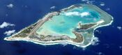
The Marshall Islands are located north of Nauru and Kiribati, east of the Federated States of Micronesia, and south of the U.S. territory of Wake Island. The islands consist of 29 low-lying atolls and 5 isolated islands,[14] comprising 1,156 individual islands and islets. The atolls and islands form two groups: the Ratak Chain and the Ralik Chain (meaning "sunrise" and "sunset" chains). All the islands in the chain are part of the Republic of the Marshall Islands, a presidential republic in free association with the United States. Having few natural resources, the islands' wealth is based on a service economy, as well as some fishing and agriculture. Of the 29 atolls, 24 of them are inhabited.
Bikini Atoll is an atoll in the Marshall Islands. There are 23 islands in the Bikini Atoll. The islands of Bokonijien, Aerokojlol and Nam were vaporized during nuclear tests that occurred there.[15] The islands are composed of low coral limestone and sand.[citation needed][16] The average elevation is only about 2.1 متر (7 ft) above low tide level.
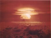
Image of the Castle Bravo nuclear test, detonated on 1 March 1954, at Bikini Atoll
![An illustration of the Cross Spikes Club[17] of the US Navy on Bikini Atoll, one of several Marshall Islands used for atomic bomb tests.](/w/images/thumb/f/f3/Cross_spikes_club.jpg/175px-Cross_spikes_club.jpg)
An illustration of the Cross Spikes Club[17] of the US Navy on Bikini Atoll, one of several Marshall Islands used for atomic bomb tests.
Kili Island is one of the smallest islands in the Marshall Islands.

![An illustration of the Cross Spikes Club[17] of the US Navy on Bikini Atoll, one of several Marshall Islands used for atomic bomb tests.](/w/index.php?title=%D9%85%D9%84%D9%81:Cross_spikes_club.jpg&filetimestamp=20130403213759&)

ناورو
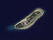
Nauru is an oval-shaped island country in the southwestern Pacific Ocean, 42 km (26 mi) south of the Equator, listed as the world's smallest republic, covering just 21 km2 (8 sq mi).[18] With 11,347 residents, it is the third least-populated country, after Vatican City and Tuvalu. The island is surrounded by a coral reef, which is exposed at low tide and dotted with pinnacles.[19] The presence of the reef has prevented the establishment of a seaport, although channels in the reef allow small boats access to the island.[20] A fertile coastal strip 150 إلى 300 m (490 إلى 980 ft) wide lies inland from the beach.[19]
Aerial view of Nauru
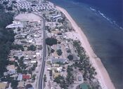
Nauruan districts of Denigomodu and Nibok


جزيرة ويك
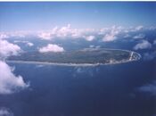
Wake Island is a coral atoll with a coastline of 19 km (12 mi) just north of the Marshall Islands. It is an unorganized, unincorporated territory of the United States. Access to the island is restricted and all activities on the island are managed by the United States Air Force. While geographically adjacent, it is not ethnoculturally part of Micronesia, due to its historical lack of human inhabitation.[citation needed] Micronesians may have possibly visited Wake Island in prehistoric times to harvest fish, but there is nothing to suggest any kind of settlement.[21]
Wake Island as depicted by the United States Exploring Expedition, drawn by Alfred Thomas Agate
Aerial view Wake Island, looking westward


الجيولوجيا
This section requires expansion. (December 2013) |
The majority of the islands in the area are part of a coral atoll. Coral atolls begin as coral reefs that grow on the slopes of a central volcano. When the volcano sinks back down into the sea, the coral continues to grow, keeping the reef at or above water level. One exception is Pohnpei in the Federated States of Micronesia, which still has the central volcano and coral reefs around it.
الوحيش
The Yap Islands host a number of endemic bird species, including the Yap monarch and the Olive white-eye, in addition to four other restricted-range bird species.[22] The endangered Yap flying-fox, though often considered a subspecies of the Pelew flying fox or the Mariana fruit bat, is also endemic to Yap.[22]

This section requires expansion. (December 2013) |
النبيت
The region has a tropical marine climate moderated by seasonal northeast trade winds. There is little seasonal temperature variation. The dry season runs from December or January to June and the rainy season from July to November or December. Because of the location of some islands, the rainy season can sometimes include typhoons.
الدول والتوابع في ميكرونيزيا
| البلد | التعداد (تقدير يوليو 2016)[23] | المساحة (كم²) | الكثافة السكانية (/km2) | Urban population | Life expectancy | Literacy rate | Official language(s) | Main religion(s) | Ethnic groups |
|---|---|---|---|---|---|---|---|---|---|
| 104,937 | 702 | 158 | 22% | 71.2 | 89% | English | Roman Catholic 50%, Protestant 47%, others 3% | Chuukese 48.8%, Pohnpeian 24.2%, Kosraean 6.2%, Yapese 5.2%, Yap outer islands 4.5%, Asian 1.8%, Polynesian 1.5%, other 7.8% | |
| 162,896 | 540 | 299 | 93% | 78.2 | 99% | English 38.3%, Chamorro 22.2%[24] | Roman Catholic 85%, Buddhism 3.6, other religion 11.4% | Chamorro 37.1%, Filipino 26.3%, other Pacific islander 11.3%, white 6.9%, other 8.6%, mixed 9.8% | |
| 114,395 | 811 | 152 | 44% | 64.0 | 92% | English, Gilbertese (de facto) | Roman Catholic 55%, Protestant 36% | Micronesian 98.8% | |
| 53,066 | 181 | 293 | 71% | 71.5 | 93.7% | Marshallese 98.2%, English | Protestant 54.8%, other Christian 40.6% | Marshallese 92.1%, mixed Marshallese 5.9%, other 2% | |
| 11,347 | 21 | 480 | 100% | 65.0 | 99%[25] | Nauruanf[›], English (de facto) | Nauru Congregational Church 35.4%, Roman Catholic 33.2%, Nauru Independent Church (Protestant)[26] 10.4%, Baha'i faith 10%, Buddhism 9% | Nauruan 58%, other Pacific Islander 26%, Chinese 8%, European 8% | |
| 55,023 | 464 | 113 | 91% | 76.9 | 97% | English, Chamorro and Carolinian[27] | Roman Catholic, Buddhism 10.6% | Asian 56.3%, Pacific islander 36.3%, White 1.8%, other 0.8%, mixed 4.8% | |
| 21,503 | 459 | 47 | 81% | 71.5 | 92% | Palauan 64.7%d[›], English | Roman Catholic 41.6%, Protestant 23.3% | Palauan 69.9%, Filipino 15.3%, Chinese 4.9%, other Asian 2.4%, white 1.9%, Carolinian 1.4%, other Micronesian 1.1%, other 3.2% | |
| Total | 523,167 | 3,178 |
السياسة
The Pacific Community (SPC) is a regional intergovernmental organization whose membership includes both nations and territories in the Pacific Ocean and their metropolitan powers.
- الولايات الماكرونية المتحدة ("ميكرونيزيا")
- جمهورية جزر مارشال
- جمهورية پالاو
- كومنولث جزر ماريانا الشمالية
- جمهورية ناورو
- جمهورية كريباتي
- گوام
- جزيرة ويك.
ميكرونيزيا . (غنيا الجديدة)
وتقع ضمن أرخبيل جزر الهند الشرقية، كما تقع إلى الشمال من أستراليا وتنقسم جزيرة غينيا الجديدة بين إندونسيا (إيريان الغربية) وأستراليا (پاپوا) وتتبعها مجموعة من الجزر تقع في شرقها وتبلغ مساحة پاپوا 234ألف كم ، وقدر عدد سكانها في سنة 1988 بحوالي 380 ألف نسمة ، والعاصمة بورت مورسبي يدين سكانها بالهندوسية ، والمسيحية، وبها أقلية مسلمة قليلة العدد، وبها عدد كبير من الوثنيين ، إلى جانب هذا البوذية والقاديانية.
الجزر
الجزر ومجموعات الجزر التالية تعتبر جزءاً من ميكرونيزيا:
- بانابا، هي جزيرة منعزلة تتبع
 كيريباس.
 - جزر گلبرت، التي تشكل جزءاً من كيريباس. جزر كيريباتي Kiribati: تتكون من مجموعات جزر: گلبرت Gilbert وفينكس Phoenix، مستقلة، مساحتها 717كم² وعدد سكانها يقارب الـ 100 ألف نسمة.
- جزر ماريانا، مقسمة سياسياً بين:
 جزر مارشال متحدة مع الولايات المتحدة، وتتمتع بالحكم الذاتي. مساحتها 181كم2 وعدد سكانها 50 ألف نسمة تقريباً.
- جزيرة گوام Guam: تابعة للولايات المتحدة، مساحتها 549كم²، ويقارب عدد سكانها الـ 200 ألف نسمة.
- جزر ماريانا الشمالية: (ما عدا گوام) هي من دول كومنولث الولايات المتحدة، المساحة 477كم²، وسكانها يقاربون الـ 25 ألف نسمة.
- جزر كارولاين، مقسمة سياسياً بين:
 پالاو و
 ميكرونزيا. اتحاد ميكرونيزيا: دولة اتحادية، تتكون من جزر الكارولين (تروك Truk، ياپ Yap، كوسرائ Kosrae، پوناپى Ponape). مساحتها 707كم²، وعدد سكانها يقارب الـ 150 ألف نسمة، العاصمة پاليكير Palikir وتقع في جزيرة پوناپى، اللغة الرسمية الإنكليزية. وقد أصبح الاتحاد جزءاً من الولايات المتحدة سنة 1986، وفي عام 1991 أصبح عضواً في الأمم المتحدة.
 ناورو مستقلة، مساحتها 21كم²، وسكانها يعدون نحو 15 ألف نسمة.
 جزيرة ويك، وهي احدى جزر الولايات المتحدة الصغيرة النائية. مساحتها 81كم²، وعدد سكانها ألف نسمة تقريباً.
إجمالي المساحة البرية: 1،229.95 ميل مربع (3،185.6 km2)
المناخ
تتصف هذه الجزر بسبب موقعها الفلكي على خطوط العرض بمناخ دافئ رطب على مدار السنة، إذ قلما تهبط درجات الحرارة فيها عن 20 ْم أو ترتفع أكثر من 27 ْم، والمدى الحراري اليومي والسنوي يراوح ما بين 5 ـ 7ْم، ويستمر الفصل المطير من أيار/مايو حتى كانون الأول/ديسمبر (موسمي)، أما فصل الخريف فيستمر من كانون الثاني/ديسمبر حتى نيسان/أبريل. وقد تشهد ميكرونيزيا بسبب موقعها الأعاصير العنيفة.
السكان
السكان اليوم يشكلون العديد من الأعراق، ولكن جميعهم ينحدر من الثقافة الميكرونيزية.[28] بعض جزر الأرخبيل خالية تماماً من السكان، وبعضها الآخر قليل السكنى، ولكن هناك جزر مأهولة بوضوح. وقد وَفَدَ السكان إلى الأرخبيل من جنوب شرقي آسيا منذ آلاف السنين واستوطنوا أولاً في ميكرونيزيا، بعدها انتشروا في جزر بولينيزيا. ويعتقد العلماء أن سكان كل من ميكرونيزيا وميلانيزيا عبارة عن مجموعات جنسية تفرعت عن النغريتوس Negritos (الأقزام الآسيويين) واختلطت بالأقزام الأوقيانوسيين. والسكان في ميكرونيزيا خليط من السكان الأصليين والأوربيين والهنود والصينيين واليابانيين؛ لذا تنوعت الثقافة في الأرخبيل تبعاً لما حمله القادمون واختلاف البيئة الجغرافية.
سكن القادمون ومازالوا في تجمعات سكانية صغيرة (أصغر من قرية) بسبب طبيعة الحياة الاقتصادية الفقيرة القائمة على الجمع والالتقاط والصيد. والميكرونيزيون متوسطو القامة لكنهم أطول من الميلانيزيين، ولهم بشرة بنية اللون، شعرهم مجعد، أما القريبون منهم من الجزر الآسيوية فلهم سمات آسيوية، مثل بروز عظام الوجه والشعر الناعم. يتحدث السكان لهجات عديدة تدعى «بولينيزية ملايو» إضافة إلى 13 لغة منها اليابانية واللهجة الهجينة (لغة محلية + لغة أجنبية). أما اللغة الرسمية فهي الإنكليزية. قسم كبير من الميكرونيزيين وثنيون ويتعاطون السحر والشعوذة، ولكن دخلت المسيحية في القرنين السابع عشر والثامن عشر واعتنقها أناس كثيرون منهم.
يعتمد السكان في غذائهم على اليام والتارو وفاكهة البحر والأناناس وجوز الهند وصيد الأسماك.
يرتدي سكان أرخبيل ميكرونيزيا في المدن لباساً غربياً، لكن الغالبية العظمى تُصنِّع ملابسها من البيئة الغابية، خاصة لحاء الشجر.
التاريخ
قبل التاريخ

The Northern Mariana Islands were the first islands in Oceania colonized by the Austronesian peoples. They were settled by the voyagers who sailed eastwards from the Philippines in approximately 1500 BCE. These populations gradually moved southwards until they reached the Bismarck Archipelago and the Solomon Islands by 1300 BCE and reconnected with the Lapita culture of the southeast migration branch of Austronesians moving through coastal New Guinea and Island Melanesia. By 1200 BCE, they again began crossing open seas beyond inter-island visibility, reaching Vanuatu, Fiji, and New Caledonia; before continuing eastwards to become the ancestors of the Polynesian people.[29][30][31]
Further migrations by other Austronesians also followed, likely from Sulawesi, settling Palau and Yap by around 1000 BCE. The details of this colonization, however, are not very well known.[29][30][32] In 200 BCE, a loosely connected group of Lapita colonists from Island Melanesia also migrated back northwards, settling the islands of eastern Micronesia almost simultaneously. This region became the center of another wave of migrations radiating outwards, reconnecting them with other settled islands in western Micronesia.[29][30]
Around 800 CE, a second wave of migrants from Southeast Asia arrived in the Marianas, beginning what is now known as the Latte period. These new settlers built large structures with distinctive capped stone pillars known as haligi. They also reintroduced rice (which did not survive earlier voyages), making the Northern Marianas the only islands in Oceania where rice was grown prior to European contact. However, it was considered a high-status crop and only used in rituals. It did not become a staple until after Spanish colonization.[31][33][34]
Construction of Nan Madol, a megalithic complex made from basalt lava logs in Pohnpei, began in around 1180 CE. This was followed by the construction of the Leluh complex in Kosrae in around 1200 CE.[30][35][36]
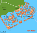
Central Nan Madol (map)


الاتصال الأوروبي المبكر

تقوم البعثات التبشيرية منذ اكتشاف جزر الأرخبيل بالعمل على نشر الديانة المسيحية والمساعدة في التعليم والصحة. وقد تبع هذه البعثات قوافل التجار الأوربيين والأمريكيين للبحث عن الثروات وتجارة العبيد وصيد الحيتان. وقد استوطن بعضهم وأقاموا مزارع لجوز الهند والبن والأناناس وقصب السكر.
The earliest known contact with Europeans occurred in 1521, when a Spanish expedition under Ferdinand Magellan reached the Marianas.[37] This contact is recorded in Antonio Pigafetta's chronicle of Magellan's voyage, in which he recounts that the Chamorro people had no apparent knowledge of people outside of their island group.[38] A Portuguese account of the same voyage suggests that the Chamorro people who greeted the travellers did so "without any shyness as if they were good acquaintances".[39]
Further contact was made during the sixteenth century, although often initial encounters were very brief. Documents relating to the 1525 voyage of Diogo da Rocha suggest that he made the first European contact with inhabitants of the Caroline Islands, possibly staying on the Ulithi atoll for four months and encountering Yap. Marshall Islanders were encountered by the expedition of Spanish navigator Álvaro de Saavedra Cerón in 1529.[40] Other contact with the Yap islands occurred in 1625.[41]
الاستعمار والتنصير

In the early 17th century Spain colonized Guam, the Northern Marianas and the Caroline Islands (what would later become the Federated States of Micronesia and the Republic of Palau), creating the Spanish East Indies, which was governed from the Spanish Philippines.
When Russian explorer Otto von Kotzebue visited the Marshall Islands in 1817, he noted that Marshallese families practiced infanticide after the birth of a third child as a form of population planning due to frequent famines.[42]
In 1819, the American Board of Commissioners for Foreign Missions—a Protestant group—brought their Puritan ways to Polynesia. Soon after, the Hawaiian Missionary Society was founded and sent missionaries into Micronesia. Conversion was not met with as much opposition, as the local religions were less developed (at least according to Western ethnographic accounts). In contrast, it took until the end of the 19th to the beginning of the 20th centuries for missionaries to fully convert the inhabitants of Melanesia; however, a comparison of the cultural contrast must take into account the fact that Melanesia has always had deadly strains of malaria present in various degrees and distributions throughout its history (see De Rays Expedition) and up to the present; conversely, Micronesia does not have—and never seems to have had—any malarial mosquitos nor pathogens on any of its islands in the past.[43]
المعاهدة الألمانية-الإسبانية 1899

In the Spanish–American War, Spain lost many of its remaining colonies. In the Pacific, the United States took possession of the Spanish Philippines and Guam. On 17 January 1899, the United States also took possession of unclaimed and uninhabited Wake Island. This left Spain with the remainder of the Spanish East Indies, about 6,000 tiny islands that were sparsely populated and not very productive. These islands were ungovernable after the loss of the administrative center of Manila and indefensible after the loss of two Spanish fleets in the war. The Spanish government therefore decided to sell the remaining islands to a new colonial power: the German Empire.
The treaty, which was signed by Spanish Prime Minister Francisco Silvela on 12 February 1899, transferred the Caroline Islands (Kosrae in the east to Palau in the west), the Mariana Islands, and other possessions to Germany. Under German control, the islands became a protectorate and were administered from German New Guinea. Nauru had already been annexed and claimed as a colony by Germany in 1888.
القرن العشرون

In the early 20th century, the islands of Micronesia were divided between three foreign powers:
- the United States, which took control of Guam following the Spanish–American War of 1898 and claimed Wake Island;
- Germany, which took Nauru and bought the Marshall, Caroline and Northern Mariana Islands from Spain; and
- the British Empire, which took the Gilbert Islands (Kiribati).
During World War I, Germany's Pacific island territories were seized and became League of Nations mandates in 1923. Nauru became an Australian mandate, while Germany's other territories in Micronesia were given as a mandate to Japan and were named the South Seas Mandate. During World War II, Nauru and Ocean Island were occupied by Japanese troops, with also an occupation of some of the Gilbert Islands and were bypassed by the Allied advance across the Pacific. Following Japan's defeat in World War II its mandate became a United Nations Trusteeship administered by the United States as the Trust Territory of the Pacific Islands.[44] Nauru became independent in 1968.
القرن 21
Today, most of Micronesia are independent states, except for the U.S. Commonwealth of the Northern Mariana Islands, Guam and Wake Island, which are U.S. territories.
السياسة
استقلَّت جزر كثيرة من الأرخبيل، لكنها لا زالت تابعة ومرتبطة بسياسات الدول التي استعمرتها. بعد الحرب العالمية الثانية أجرت الولايات المتحدة الأمريكية فوق بعض جزر ميكرونيزيا تجارب نووية. وعلى الرغم من ذلك تقيم معظم جزر الأرخبيل المستقلة ـ وخاصة دولة ميكرونيزيا ـ أفضل العلاقات مع الولايات المتحدة مقابل مساعدة سنوية تقدر بـنحو 58 مليون دولار؛ على أن تلتزم التصويت في الأمم المتحدة لمصلحتها، إلى جانب وضع أراضيها في الخدمة الأمريكية.
دولة ميكرونيزيا من المؤيدين الدائمين لإسرائيل، وترتبط معها بعلاقات قوية وودية مقابل بعض المساعدات الطبية والرياضية.
الاقتصاد
.svg&filetimestamp=20230712144746&)
تحفل جزر الأرخبيل بالعديد من الثروات المعدنية وشبه المعدنية مثل : النيكل والنحاس الأصفر والذهب والفضة والنفط والكروم والحديد والحجر الجيري والفوسفات. الصناعة ضعيفة عموماً وتقوم على استثمارات أجنبية تهتم باستغلال الثروات المذكورة آنفاً، وتطوير صناعات زيت جوز الهند والصابون والسكر والأخشاب والإسمنت والتبغ والكبريت وصيد الحيتان. أما الصناعات اليدوية فتعتمد على السلال والحصر والخشب المحفور. التعليم مازال متواضعاً يستفيد منه عدد ضئيل من السكان في المراحل الابتدائية والثانوية إلى جانب بعض الكليات والمعاهد.
أما وسائل المواصلات في هذه البيئة الجزرية فتقتصر على أنواع مختلفة من الزوارق، ولكن منذ خمسينات القرن العشرين انتشرت الموانئ والمطارات، وعملت السفن والطائرات على ربط جزر الأرخبيل بعضها ببعض وبالعالم الخارجي. شبكات الطرق البرية لازالت محدودة.
من أهم ثروات أرخبيل ميكرونيزيا الزارعية: قصب السكر والأرز و البطاطا الحلوة و الموز وجوز الهند والكاسافا والكوبرا (لب جوز الهند المجفف) والكاكاو، ويربى الخنزير على نطاق واسع في كل جزر المحيط الهادي.
Most residents of Micronesia can freely move to and work within, the United States. Relatives working in the US who send money home to relatives represent the primary source of individual income. Additional individual income comes mainly from government jobs and work within shops and restaurants.
The tourist industry consists mainly of scuba divers that come to see the coral reefs, do wall dives and visit sunken ships from WWII. Major stops for scuba divers in approximate order are Palau, Chuuk, Yap and Pohnpei. Some private yacht owners visit the area for months or years at a time. However, they tend to stay mainly at ports of entry and are too few in number to be counted as a major source of income.
Copra production used to be a more significant source of income, however, world prices have dropped in part to large palm plantations that are now planted in places like Borneo.
السكان
The people today form many ethnicities, but all are descended from and belong to the Micronesian culture.[45]
Because of this mixture of descent, many of the ethnicities of Micronesia feel closer to some groups in Melanesia, or the Philippines. A good example of this are the Yapese people who are related to Austronesian tribes in the northern Philippines.[46] Genetics also show a significant number of Micronesian have Japanese paternal ancestry: 9.5% of males from Micronesia as well as 0.2% in East Timor carry the Haplogroup D-M55.[47]
There are also substantial Asian communities found across the region, most notably in the Northern Mariana Islands where they form the majority and smaller communities of Europeans who have migrated from the United States or are descendants of settlers during European colonial rule in Micronesia.
Though they are all geographically part of the same region, they all have very different colonial histories. The US-administered areas of Micronesia have a unique experience that sets them apart from the rest of the Pacific. Micronesia has great economic dependency on its former or current motherlands, something only comparable to the French Pacific. Sometimes, the term American Micronesia is used to acknowledge the difference in cultural heritage.[48]
A 2011 survey found that 93.1% of Micronesian are Christians;[49] a survey in 2022 showed that 99% were Christian.[50]
الجماعات الأصلية
الميكرونيزيون
شعب الكارولين
It is thought that ancestors of the Carolinian people may have originally immigrated from the Asian mainland and Indonesia to Micronesia around 2,000 years ago. Their primary language is Carolinian, called Refaluwasch by native speakers, which has a total of about 5,700 speakers. The Carolinians have a matriarchal society in which respect is a very important factor in their daily lives, especially toward the matriarchs. Most Carolinians are of the Roman Catholic faith.
The immigration of Carolinians to Saipan began in the early 19th century, after the Spanish reduced the local population of Chamorro natives to just 3,700. They began to immigrate mostly sailing from small canoes from other islands, which a typhoon previously devastated. The Carolinians have a much darker complexion than the native Chamorros.
Chamorro people

The Chamorro people are the indigenous peoples of the Mariana Islands, which are politically divided between the United States territory of Guam and the United States Commonwealth of the Northern Mariana Islands in Micronesia. The Chamorro are commonly believed to have come from Southeast Asia at around 2000 BC. They are most closely related to other Austronesian natives to the west in the Philippines and Taiwan, as well as the Carolines to the south.
The Chamorro language is included in the Malayo-Polynesian subgroup of the Austronesian family. Because Guam was colonized by Spain for over 300 years, many words derive from the Spanish language. The traditional Chamorro number system was replaced by Spanish numbers.[51]
Chuukese people
The Chuukese people are an ethnic group in Oceania. They constitute 48% of the population of the Federated States of Micronesia. Their language is Chuukese. The home atoll of Chuuk is also known by the former name Truk.
Nauruan people
The Nauruan people are an ethnicity inhabiting the Pacific island of Nauru. They are most likely a blend of other Pacific peoples.[52]
The origin of the Nauruan people has not yet been finally determined. It can possibly be explained by the last Malayo-Pacific human migration (c. 1200). It was probably seafaring or shipwrecked Polynesians or Melanesians that established themselves in Nauru because there was not already an indigenous people present, whereas the Micronesians were already crossed with the Melanesians in this area.
Kaping people
The roughly 3000 residents of the Federated States of Micronesia that reside in Kapingamarangi, nicknamed 'Kapings', live in one of the most remote locations in both Micronesia and the world at large. Their home atoll is almost 320 km (200 mi) from the nearest point of immigration.[53] There are no regular flights; the only reliable way to legally visit is to travel on a high-speed sailboat to the atoll. Owing to this difficulty, few sailors travelling the Pacific attempt to visit. The local language is the Kapingamarangi language. From the 1970s, to attend high school the children needed to travel to Pohnpei, bringing their parents with them to create communities of Kapings on the island.[54]
الجماعات المهاجرة
East, South, and Southeast Asian people
There are large East, South and Southeast Asian communities found across certain Micronesian countries that are either immigrants, foreign workers or descendants of either one, most migrated to the islands during the 1800s and 1900s.[55] According to the 2010 census results Guam was 26.3% Filipino, 2.2% Korean, 1.6% Chinese and 2% other Asian.[56] The 2010 census showed the Northern Mariana Islands was 50% Asian of which 35.3% were Filipino, 6.8% Chinese, 4.2% Korean and 3.7% other Asian (mainly Japanese, Bangladeshi and Thai).[57] The 2010 census for the Federated States of Micronesia showed 1.4% were Asian while statistics for Nauru showed 8% of Nauruans were Chinese.[58][59] The 2005 census results for Palau showed 16.3% were Filipino, 1.6% Chinese, 1.6% Vietnamese and 3.4% other Asian (mostly Bangladeshi, Japanese and Korean).[60]
Japanese rule in Micronesia also led to Japanese people settling the islands and marrying native spouses. Kessai Note, the former president of the Marshall Islands has partial Japanese ancestry by way of his paternal grandfather, and Emanuel Mori, the former president of the Federated States of Micronesia, is descended from one of the first settlers from Japan, Koben Mori.
A significant number of Micronesians were shown to have paternal genetic relations with Japanese Haplogroup D-M55. Genetic testing found that 9.5% of males from Micronesia as well as 0.2% in East Timor[61] carry what is believed to reflect recent admixture from Japan. That is, D-M116.1 (D1b1) is generally believed to be a primary subclade of D-M64.1 (D1b), possibly as a result of the Japanese military occupation of Southeast Asia during World War II.[47]
الأوروبيون
The 2010 census results of Guam showed 7.1% were white while the 2005 census for Nauru showed 8% were European. Smaller numbers at 1.9% in Palau and 1.8% in the Northern Mariana Islands were recorded as "white". In conjunction to the European communities there are large amounts of mixed Micronesians, some of which have European ancestry.

.jpg&filetimestamp=20120413031641)
.svg&filetimestamp=20230712144746)
اللغات
The largest group of languages spoken in Micronesia are the Micronesian languages. They are in the family of Oceanic languages, part of the Austronesian language group. They descended from the Proto-Oceanic, which in turn descended via Proto-Malayo-Polynesian from Proto-Austronesian. The languages in the Micronesian family are Marshallese, Gilbertese, Kosraean, Nauruan, as well as a large sub-family called the Chuukic–Pohnpeic languages containing 11 languages.
On the eastern edge of the Federated States of Micronesia, the languages Nukuoro and Kapingamarangi represent an extreme westward extension of the Polynesian branch of Oceanic.
Finally, there are two Malayo-Polynesian languages spoken in Micronesia that do not belong to the Oceanic languages: Chamorro in the Mariana Islands and Palauan في پالاو.
الثقافة
الحيوانات والطعام
By the time Western contact occurred, although Palau did not have dogs, they did have fowls and possibly pigs. Pigs are not native to Micronesia. Fruit bats are native to Palau, but other mammals are rare. Reptiles are numerous and both mollusks and fish are an important food source.[62] The people of Palau, the Marianas and Yap often chew betel nuts seasoned with lime and pepper leaf. Western Micronesia was unaware of the ceremonial drink, which was called saka on Kosrae and sakau on Pohnpei.[32]
العمارة
The book Prehistoric Architecture in Micronesia argues that the most prolific pre-colonial Micronesian architecture is "Palau's monumental sculpted hills, megalithic stone carvings and elaborately decorated structure of wood placed on piers above elevated stone platforms".[63] The archeological traditions of the Yapese people remained relatively unchanged even after the first European contact with the region during Magellan's 1520s circumnavigation of the globe.[32]
الفن
Micronesia's artistic tradition has developed from the Lapita culture. Among the most prominent works of the region is the megalithic floating city of Nan Madol. The city began in 1200 CE and was still being built when European explorers begin to arrive around 1600. The city, however, had declined by around 1800 along with the Saudeleur dynasty and was completely abandoned by the 1820s. During the 19th century, the region was divided between the colonial powers, but art continued to thrive. Wood-carving, particularly by men, flourished in the region, resulted in richly decorated ceremonial houses in Belau, stylized bowls, canoe ornaments, ceremonial vessels and sometimes sculptured figures. Women created textiles and ornaments such as bracelets and headbands. Stylistically, traditional Micronesian art is streamlined and of a practical simplicity to its function, but is typically finished to a high standard of quality. [64] This was mostly to make the best possible use of what few natural materials they had available to them.[65]
The first half of the 20th century saw a downturn in Micronesia's cultural integrity and a strong foreign influence from both western and Japanese Imperialist powers. A number of historical artistic traditions, especially sculpture, ceased to be practiced, although other art forms continued, including traditional architecture and weaving. Independence from colonial powers in the second half of the century resulted in a renewed interest in, and respect for, traditional arts. A notable movement of contemporary art also appeared in Micronesia towards the end of the 20th century.[66]
المطبخ
The cuisine of the Mariana Islands is tropical in nature, including such dishes as kelaguen as well as many others.
Marshallese cuisine comprises the fare and foodways of the Marshall Islands, and includes local foods such as breadfruit, taro root, pandanus and seafood, among others.
Palauan cuisine includes local foods such as cassava, taro, yam, potato, fish and pork. Western cuisine is favored among young Palauans.
التعليم
The educational systems in the nations of Micronesia vary depending on the country and there are several higher-level educational institutions.
The CariPac consists of institutions of higher education in Guam, the Northern Mariana Islands, American Samoa, Puerto Rico, the U.S. Virgin Islands, the Federated States of Micronesia, the Marshall Islands and Palau. The Agricultural Development in the American Pacific is a partnership of the University of Hawaii, American Samoa Community College, College of Micronesia, Northern Marianas College and the University of Guam.
In the Federated States of Micronesia, education is required for citizens aged 6 to 13,[67] and is important to their economy.[68] The literacy rate for citizens aged 15 to 24 is 98.8%.[69] The College of Micronesia-FSM has a campus in each of the four states with its national campus in the capital city of Palikir, Pohnpei. The COM-FSM system also includes the Fisheries and Maritime Institute (FMI) on the Yap islands.[70][71]
The public education in Guam is organized by the Guam Department of Education. Guam also has several educational institutions, such as University of Guam, Pacific Islands University and Guam Community College, There is also the Guam Public Library System and the Umatac Outdoor Library.
Weriyeng[72] is one of the last two schools of traditional navigation found in the central Caroline Islands in Micronesia, the other being Fanur.[73]
The Northern Marianas College is a two-year community college located in the United States Commonwealth of the Northern Mariana Islands (CNMI).
The College of the Marshall Islands is a community college in the Marshall Islands.
القانون
Understanding Law in Micronesia notes that The Federated States of Micronesia's laws and legal institutions are "uninterestingly similar to [those of Western countries]". However, it explains that "law in Micronesia is an extraordinary flux and flow of contrasting thought and meaning, inside and outside the legal system". It says that a knee-jerk reaction would be that law is disarrayed in the region and that improvement is required, but argues that the failure is "one endemic to the nature of law or to the ideological views we hold about law".[74]
The Trust Territory of the Pacific Islands, a United Nations Trusteeship administered by the United States, borrowed heavily from United States law in establishing the Trust Territory Code during the Law and Development movement of the late 1950s and early 1960s. Many of those provisions were adopted by the new Congress of the Federated States of Micronesia when the Federated States of Micronesia became self-governing in 1979.[74]
Media
In September 2007, journalists in the region founded the Micronesian Media Association.[75]
Music and dance
Micronesian music is influential to those living in the Micronesian islands.[76] Some of the music is based around mythology and ancient Micronesian rituals. It covers a range of styles from traditional songs, handed down through generations, to contemporary music.
Traditional beliefs suggest that the music can be presented to people in dreams and trances, rather than being written by composers themselves. Micronesian folk music is, like Polynesian music, primarily vocal-based.
In the Marshall Islands, the roro is a kind of traditional chant, usually about ancient legends and performed to give guidance during navigation and strength for mothers in labour. Modern bands have blended the unique songs of each island in the country with modern music. Though drums are not generally common in Micronesian music, one-sided hourglass-shaped drums are a major part of Marshallese music.[77] There is a traditional Marshallese dance called beet, which is influenced by Spanish folk dances; in it, men and women side-step in parallel lines. There is a kind of stick dance performed by the Jobwa, nowadays only for very special occasions.
Popular music, both from Micronesia and from other areas of the world, is played on radio stations in Micronesia.[76]
الرياضة
The region is home to the Micronesian Games.[78] This quadrennial international multi-sport event involves all of Micronesia's countries and territories except Wake Island.
Nauru has two national sports, weightlifting and Australian rules football.[79] According to 2007 Australian Football League International Census figures, there are around 180 players in the Nauru senior competition and 500 players in the junior competition,[80] representing a participation rate of over 30% overall for the country.
الدين والأساطير
The predominant religion in Micronesia is Christianity (93%)[49] According to 2023 government statistics, 55% of the population were Catholic and 42% were Protestant, while 2% belonged to other Christian denominations. Other religious groups exist including Baha’is, Buddhists, Hindus, Jews, and Muslims.[50]
Micronesian mythology comprises the traditional belief systems of the people of Micronesia. There is no single belief system in the islands of Micronesia, as each island region has its own mythological beings. It was noted that 2.7% of the population followed folk religions in 2014.[50]
There are several significant figures and myths in the traditions of the Federated States of Micronesia, Nauru, and Kiribati.
Shinto shrines dating from during or after World War II exist in some Micronesian countries.[81]
انظر أيضاً
الهامش
- ^ Patrick Vinton Kirch, On the Road of the Winds: an Archeological History of the Pacific Islands before European Contact, Berkeley, University of California Press, 2000:5.
- ^ Kirch 2001, p. 167.
- ^ Doran, Edwin B. (1981). Wangka: Austronesian Canoe Origins. Texas A&M University Press. ISBN 9780890961070.
- ^ Dierking, Gary (2007). Building Outrigger Sailing Canoes: Modern Construction Methods for Three Fast, Beautiful Boats. International Marine/McGraw-Hill. ISBN 9780071594561.
- ^ Horridge, Adrian (1986). "The Evolution of Pacific Canoe Rigs". The Journal of Pacific History. 21 (2): 83–89. doi:10.1080/00223348608572530. JSTOR 25168892.
- ^ Bellwood, Peter (1988). "A Hypothesis for Austronesian Origins" (PDF). Asian Perspectives. 26 (1): 107–117. Archived (PDF) from the original on 1 May 2019. Retrieved 1 May 2019.
- ^ Bellwood, Peter (1991). "The Austronesian Dispersal and the Origin of Languages". Scientific American. 265 (1): 88–93. Bibcode:1991SciAm.265a..88B. doi:10.1038/scientificamerican0791-88. JSTOR 24936983.
- ^ Hill, Adrian V.S.; Serjeantson, Susan W., eds. (1989). The Colonization of the Pacific: A Genetic Trail. Research Monographs on Human Population Biology No. 7. Oxford University Press. ISBN 9780198576952.
- ^ Bellwood P, Fox JJ, Tryon D (2006). The Austronesians: Historical and Comparative Perspectives. Australian National University Press. ISBN 9781920942854. Archived from the original on 2 April 2020. Retrieved 23 March 2019.
- ^ Blench, Roger (2012). "Almost Everything You Believed about the Austronesians Isn't True" (PDF). In Tjoa-Bonatz, Mai Lin; Reinecke, Andreas; Bonatz, Dominik (eds.). Crossing Borders. National University of Singapore Press. pp. 128–148. ISBN 9789971696429. Archived (PDF) from the original on 30 December 2019. Retrieved 23 March 2019.
- ^ Rainbird 2004, p. 6.
- ^ « Although based on a superficial understanding of the Pacific islanders, Dumont d’Urville’s tripartite classification stuck. Indeed, these categories — Polynesians, Micronesians, Melanesians — became so deeply entrenched in Western anthropological thought that it is difficult even now to break out the mould in which they entrap us (Thomas, 1989). Such labels provide handy geographical referents, yet they mislead us greatly if we take them to be meaningful segments of cultural history. Only Polynesia has stood the tests of time and increased knowledge, as a category with historical significance », Patrick Vinton Kirch, On the Road of the Winds : an Archeological History of the Pacific Islands before European Contact, Berkeley, University of California Press, 2000 : 5.
- ^ Kirch 2001, p. 165.
- ^ "Geography Overview". Embassy of the Republic of the Marshall Islands. Republic of the Marshall Islands. Archived from the original on 15 نوفمبر 2013.
- ^ "Bikini Atoll Reference Facts". Bikini Atoll. Retrieved 12 August 2013.
- ^ Emery, Kenneth O.; Tracey, J. I. Jr.; Ladd, H.S. (1954). "Geology of Bikini and Nearby Atolls" (PDF). Retrieved 20 April 2021.
{{cite web}}: CS1 maint: url-status (link) - ^ "Operation Crossroads: Bikini Atoll". Navy Historical Center. Department of the Navy. Archived from the original on 21 May 2000. Retrieved 4 December 2013.
- ^ Central Intelligence Agency (2011). "Nauru". The World Factbook. Retrieved 12 February 2011.
- ^ أ ب "Background Note: Nauru". State Department Bureau of East Asian and Pacific Affairs. September 2005. Retrieved 11 May 2006.
- ^ Thaman, RR; Hassall, DC (1996). "Nauru: National Environmental Management Strategy and National Environmental Action Plan" (PDF). South Pacific Regional Environment Programme. p. 234.
- ^ https://www.sprep.org/attachments/15.pdf[bare URL PDF]
- ^ أ ب "Yap Islands State, Federated States of Micronesia | Ecoregions | WWF". World Wildlife Fund (in الإنجليزية). Retrieved 2021-01-12.
- ^ "World Population Prospects: The 2017 Revision". ESA.UN.org (custom data acquired via website). United Nations Department of Economic and Social Affairs, Population Division. Retrieved 10 September 2017.
- ^ Languages of Guahan, n.d., http://ns.gov.gu/language.html, retrieved on 12 November 2010
- ^ "Nauru". TalkTalk. Tiscali UK Limited. 2010. Archived from the original on 20 June 2010. Retrieved 12 November 2010.
- ^ "Nauru". TravelBlog. TravelBlog.org. 24 August 2006. Retrieved 12 November 2010.
- ^ "Commonwealth of the Northern Mariana Islands: Overview". Office of Insular Affairs. U.S. Department of the Interior, Office of Insular Affairs. Archived from the original on 9 June 2007. Retrieved 12 November 2010.
- ^ Hudjashov, Georgi; Endicott, Phillip; Post, Helen; Nagle, Nano; Ho, Simon Y. W.; Lawson, Daniel J.; Reidla, Maere; Karmin, Monika; Rootsi, Siiri; Metspalu, Ene; Saag, Lauri (2018-01-29). "Investigating the origins of eastern Polynesians using genome-wide data from the Leeward Society Isles". Scientific Reports (in الإنجليزية). 8 (1): 1823. Bibcode:2018NatSR...8.1823H. doi:10.1038/s41598-018-20026-8. ISSN 2045-2322. PMC 5789021. PMID 29379068.
- ^ أ ب ت ث Chambers, Geoff (15 January 2013). "Genetics and the Origins of the Polynesians". eLS. John Wiley & Sons, Inc. doi:10.1002/9780470015902.a0020808.pub2. ISBN 978-0470016176.
- ^ أ ب ت ث Wilson, Meredith; Ballard, Chris (2018). "Rock Art of the Pacific: Context and Intertextuality". In David, Bruno; McNiven, Ian J. (eds.). The Oxford Handbook of the Archaeology and Anthropology of Rock Art. Oxford University Press. pp. 221–252. ISBN 9780190844950.
- ^ أ ب Bellwood, Peter (9 December 2011). "The Checkered Prehistory of Rice Movement Southwards as a Domesticated Cereal—from the Yangzi to the Equator" (PDF). Rice. 4 (3–4): 93–103. doi:10.1007/s12284-011-9068-9. S2CID 44675525.
- ^ أ ب ت Morgan 1988, p. 30.
- ^ Carson, Mike T. (2012). "An overview of latte period archaeology" (PDF). Micronesica. 42 (1/2): 1–79.
- ^ Peterson, John A. (2012). "Latte villages in Guam and the Marianas: Monumentality or monumenterity?" (PDF). Micronesica. 42 (1/2): 183–08.
- ^ Richards, Zoe T.; Shen, Chuan-Chou; Hobbs, Jean-Paul A.; Wu, Chung-Che; Jiang, Xiuyang; Beardsley, Felicia (March 2015). "New precise dates for the ancient and sacred coral pyramidal tombs of Leluh (Kosrae, Micronesia)". Science Advances. 1 (2): e1400060. Bibcode:2015SciA....1E0060R. doi:10.1126/sciadv.1400060. PMC 4643814. PMID 26601144.
- ^ Rainbird, Paul; Wilson, Meredith (2 January 2015). "Crossing the line: the enveloped cross in Pohnpei, Federated States of Micronesia". Antiquity. 76 (293): 635–636. doi:10.1017/S0003598X00091018. S2CID 161654405.
- ^ Tucker, Spencer (2009). The Encyclopedia of the Spanish-American and Philippine-American Wars: A Political, Social, and Military History. Santa Barbara, California: ABC CLIO. ISBN 9781851099511.
- ^ Levesque, Rodrigue, ed. (1992–1997). History of Micronesia: A collection of source documents, Vols. 1–20. Quebec, Canada: Levesque Publications. pp. 249, 251.
- ^ Rainbird 2004, p. 13-14.
- ^ Emery, Kenneth O.; Tracey, J I.; Ladd, H. S. (1954). Geology of Bikini and Nearby Atolls. Geological Survey Professional Papers. 260. p. 3. Archived from the original. You must specify the date the archive was made using the
|archivedate=parameter. https://books.google.com/books?id=CegqAQAAIAAJ&q=%C3%81lvaro+de+Saavedra+marshall+islands&pg=PA3. - ^ Rainbird 2004, p. 14.
- ^ Hezel, Francis X. (1983). The First Taint of Civilization: A History of the Caroline and Marshall Islands in Pre-colonial Days, 1521–1885. Pacific Islands Monograph Series. Honolulu: University of Hawaii Press. pp. 92–94. ISBN 9780824816438.
- ^ Ridgell, Reilly (1995). Pacific Nations and Territories: The Islands of Micronesia, Melanesia, and Polonesia (Third, Revised ed.). Honolulu, Hawai'i: Bess Press. p. 43. ISBN 9781573060011.
- ^ Pelzer, Karl J. (1950). "Micronesia—A Changing Frontier". World Politics (in الإنجليزية). 2 (2): 251–266. doi:10.2307/2009190. ISSN 1086-3338. JSTOR 2009190. S2CID 154463511.
- ^ Hudjashov, Georgi; Endicott, Phillip; Post, Helen; Nagle, Nano; Ho, Simon Y. W.; Lawson, Daniel J.; Reidla, Maere; Karmin, Monika; Rootsi, Siiri; Metspalu, Ene; Saag, Lauri (2018-01-29). "Investigating the origins of eastern Polynesians using genome-wide data from the Leeward Society Isles". Scientific Reports (in الإنجليزية). 8 (1): 1823. Bibcode:2018NatSR...8.1823H. doi:10.1038/s41598-018-20026-8. ISSN 2045-2322. PMC 5789021. PMID 29379068.
- ^ "Micronesians - Introduction, Location, Language, Folklore, Religion, Major holidays, Rites of passage". everyculture.com.
- ^ أ ب Tumonggor, Meryanne K; Karafet, Tatiana M; Downey, Sean; Lansing, J Stephen; Norquest, Peter; Sudoyo, Herawati; Hammer, Michael F; Cox, Murray P (September 2014). "Isolation, contact and social behavior shaped genetic diversity in West Timor". Journal of Human Genetics. 59 (9): 494–503. doi:10.1038/jhg.2014.62. PMC 4521296. PMID 25078354.
- ^ Kiste, Robert C.; Marshall, Mac, eds. (1999). American Anthropology in Micronesia: An Assessment. Honolulu, Hawai'i: University of Hawai'i Press. p. 1. ISBN 9780824820176.
- ^ أ ب Center for the Study of Global Christianity (June 2013), Christianity in its Global Context, 1970–2020: Society, Religion, and Mission, South Hamilton, Massachusetts, USA: Gordon-Conwell Theological Seminary, http://wwwgordonconwell.com/netcommunity/CSGCResources/ChristianityinitsGlobalContext.pdf
- ^ أ ب ت US State Dept 2022 report
- ^ Rodríguez-Ponga Salamanca, Rafael (2009). Del español al chamorro: Lenguas en contacto en el Pacífico [From Spanish to Chamorro: languages in contact in the Pacific] (in الإسبانية). Madrid: Ediciones Gondo. ISBN 978-84-933774-4-1. OCLC 436267171.
- ^ Bay-Hansen, C.D. (2006). FutureFish 2001: FutureFish in Century 21: The North Pacific Fisheries Tackle Asian Markets, the Can-Am Salmon Treaty, and Micronesian Seas. Trafford Publishing. p. 277. ISBN 1-55369-293-4.
- ^ Oliver, Douglas L. (2022). Oceania: The Native Cultures of Australia and the Pacific Islands. Vol. 1. Honolulu: University of Hawaii Press. p. 274. ISBN 978-0-82484-570-4.
- ^ >Drummond, Emily; Rudolph, Johnny (2021). "Nukuoro (Nukuoro Atoll, Pohnpei State, Federated States of Micronesia) – Language Snapshot". Language Documentation and Description (20): 149.
- ^ Crocombe, R. G. (1 January 2007). Asia in the Pacific Islands: Replacing the West. IPS Publications, University of the South Pacific. ISBN 9789820203884 – via Google Books.
- ^ "Guam Ethnic groups - Demographics". indexmundi.com.
- ^ "Northern Mariana Islands Demographics Profile 2016". indexmundi.com.
- ^ "Federated States of Micronesia Ethnic groups - Demographics". indexmundi.com.
- ^ "Nauru Ethnic groups - Demographics". indexmundi.com.
- ^ "Palau Ethnic groups - Demographics". indexmundi.com.
- ^ Hammer, Michael F.; Karafet, Tatiana M.; Park, Hwayong; Omoto, Keiichi; Harihara, Shinji; Stoneking, Mark; Horai, Satoshi (2006). "Dual origins of the Japanese: Common ground for hunter-gatherer and farmer Y chromosomes". Journal of Human Genetics. 51 (1): 47–58. doi:10.1007/s10038-005-0322-0. PMID 16328082.
- ^ Morgan 1988, p. 3.
- ^ Morgan 1988, p. 2.
- ^ "Micronesia, 1800–1900 a.d". Heilbrunn Timeline of Art History. The Metropolitan Museum of Art. 2000. Archived from the original on 1 December 2008.
- ^ "Oceanic art". Columbia Encyclopedia (Sixth ed.). Columbia University Press. 2006.
- ^ "Micronesia, 1900 a.d.–present". Heilbrunn Timeline of Art History. The Metropolitan Museum of Art. 2000. Archived from the original on 21 May 2009.
- ^ "Education Profile of Micronesia, Micronesia Education, Education in Micronesia, Universities in Micronesia, Schools in Micronesia, Micronesia Education Profile". micronesiaeducation.info. Archived from the original on 25 April 2012. Retrieved 13 October 2011.
- ^ Dunford, Betty; Ridgell, Reilly (1996). Pacific neighbors : the islands of Micronesia, Melanesia, and Polynesia. Honolulu, Hawaii: Bess Press. ISBN 1-57306-023-2.
- ^ "UNESCO Institute for Statistics". UNESCO. Retrieved 13 October 2011.
- ^ "Fisheries and Maritime Institute". College of Micronesia - FSM. College Of Micronesia-FSM. 1 December 2011.
- ^ "Outline of the Fisheries Training Project in the Federated States of Micronesia". Japan International Cooperation Agency. Archived from the original on 2007-09-28.
Partner Country's Implementing Organization: Fisheries and Maritime Institute (FMI), College of Micronesia (COM)
- ^ Gladwin, Thomas (1970). East Is a Big Bird. Cambridge, Massachusetts: Harvard University Press. pp. 200. ISBN 0-674-22425-6.
- ^ Woodward, David (1998). History of Cartography. University of Chicago Press. p. 470. ISBN 0-226-90728-7. Retrieved 2010-08-04.
- ^ أ ب Tamanaha, Brian Z. (1993). Understanding Law in Micronesia: An Interpretive Approach to Transplanted Law. Leiden, Netherlands: E.J. Brill. pp. 1–2. ISBN 9004097686.
- ^ "Regional journalists form Micronesian media group". Saipan Tribune. 26 September 2007. Archived from the original on 16 January 2008.
- ^ أ ب "The Music and Dance of Micronesia". The Concise Garland Encyclopedia of World Music, Volume 1. New York: Routledge. 2013. pp. 697–706. ISBN 978-1136095702.
- ^ Telford, Hans W. (n.d.). "Music of the Pacific Island Nations". Music Archive for Pacific Island Nations. School of Arts, Southern Cross University. Archived from the original on 12 October 2007.
- ^ "Micronesian Games begin in Palau". Asia Pacific News. Australian Broadcasting Corporation. August 1, 2010. Archived from the original on 15 December 2013. Retrieved 15 December 2013.
- ^ Australian Sports Commission (2004), Pacific Sporting Needs Assessment, Australian Government, http://www.ausport.gov.au/international/development/docs/nauru.pdf
- ^ "INTERNATIONAL FOOTBALL CENSUS 2007: Clubs & Players - Internationally" (PDF). Australian Football League. Archived from the original (PDF) on 24 مايو 2011.
- ^ Oskow, Noah (2020-07-13). "When Japan Ruled the Waves: The Forgotten Colonies of Micronesia". Unseen Japan (in الإنجليزية الأمريكية). Retrieved 2023-09-24.
للاستزادة
- Kirch, Patrick Vinton (2000). On the Road of the Winds. An Archaeological History of the Pacific Islands before European Contact. University of California Press. pp. 166–167. ISBN 0-520-22347-0.
- Goetzfridt, Nicholas J. and Karen M. Peacock. (2002) Micronesian Histories: An Analytical Bibliography and Guide to Interpretations. Westport. CT: Greenwood Press.
وصلات خارجية
| |||||||||||||
| مناطق العالم | |||||||||||||||||||||||||
|---|---|---|---|---|---|---|---|---|---|---|---|---|---|---|---|---|---|---|---|---|---|---|---|---|---|
|
| ||||||||||||||||||||||||
| انظر أيضاً قارات العالم | |||||||||||||||||||||||||
- CS1 maint: url-status
- All articles with bare URLs for citations
- Articles with bare URLs for citations from March 2022
- Articles with PDF format bare URLs for citations
- CS1 الإسبانية-language sources (es)
- CS1 الإنجليزية الأمريكية-language sources (en-us)
- Short description is different from Wikidata
- Articles with unsourced statements from May 2020
- Articles with unsourced statements from February 2023
- Articles to be expanded from December 2013
- All articles to be expanded
- Articles with hatnote templates targeting a nonexistent page
- دول اوقيانوسية
- Biodiversity hotspots
- مايكرونيزيا
- Asia-Pacific
- Islands of Oceania
- Regions of Oceania