جزيرة عيد الفصح
| Easter Island Isla de Pascua Rapa Nui | |
|---|---|
 | |
| العاصمة | هانگا رؤا |
| اللغات الرسمية | Spanish, Rapa Nui [1] |
| جماعات عرقية (2002) | Rapanui 60%, European or mestizo 39%, Amerindian 1% |
| صفة المواطن | Rapa Nui or Pascuense |
| الحكم | Special territory of Chile[2] |
• Provincial Governor | Melania Carolina Hotu Hey |
• العمدة | Luz Zasso Paoa |
| الضم إلى تشيلي | |
• Treaty signed | September 9, 1888 |
| المساحة | |
• إجمالي | 163.6 km2 (63.2 sq mi) |
| التعداد | |
• تعداد 2002 | 3,791 |
• Density | 23.17/km2 (60.0/sq mi) |
| العملة | Peso (CLP) |
| منطقة التوقيت | Central Time Zone (UTC-6) |
| Calling code | 56 32 |
| Internet TLD | .cl |


 مقالة مفصلة: إكسير الشباب من تربة جزيرةعيد الفصح
جزيرة عيد الفصح هي جزيرة تقع في المحيط الهادي الجنوبي، وهي جزء من تشيلي. موقعها يبعد بحوالي 3600 كيلومتر (2237 ميل) عن غرب تشيلي القارية، وبحوالي 2075 كيلومتر (1290 ميل) شرق جزر بيتكيرن. تعتبر إحدى أكثر الجزر المعزولة المسكونة في العالم. إن الجزيرة مثلثية تقريباً في الشكل، ومساحتها 163.6 كيلومتر مربع (63 ميل مربع). عدد سكانها 3791 (إحصاء السكان لعام 2002)، 3304 منهم يعيشون في عاصمة هانجا روا. إن الجزيرة مشهورة بالمواي العديدة، وهي التماثيل الصخرية الموجودة الآن على طول الأشرطة الساحلية. إدارياً، تعتبر محافظة (تحتوي على بلدية واحدة) من منطقة فالباريسو التشيلية.


التاريخ
| متنزه راپا نوي الوطني Rapa Nui National Park | |
|---|---|
 | |
| أسس الاختيار | ثقافي: i, iii, v |
| المراجع | 715 |
| Inscription | 1995 (19th Session) |
تحتوى جزيرة القيامة المنعزلة على المئات من التماثيل الغريبة المتشابهة والتماثيل عبارة عن نموذجا بشريا محددا بعضهم له غطاء مستدير حول الرأس يزن وحده 10 طن, وكل تمثال منها يمثل الرأس والجذع فقط وأحيانا الأذرع وبلا أرجل ولقد تم صنع هذه التماثيل من الرماد البركانى بعد كبسه وضغطه ثم صقله وتسويته ويبلغ وزن كل تمثال 50 طن وطول كل منهم 32 مترا بالضبط ولم يستطع العلماء حتى الآن تفسير لغز هذه التماثيل المتماثلة المنتشرة في كل مكان بالجزيرة خصوصا على سواحلها ولقد تم اكتشاف الجزيرة بالصدفة عام 1722م حينما عثر عليها المستكشف الهولندى ( ياكوب روگڤين ) وجزيرة القيامة تقع في المحيط الهادئ الجنوبى وتقع على بعد 3700 كم غرب تشيلي وقد حكمت تشيلي الجزيرة منذ عام 1888م.
وعندما عثر عليها المستكشف الهولندى كان ذلك في يوم يوافق عيد الفصح أو القيامة لذلك فقد أطلق عليها اسم العيد نفسه ولهذا يطلق عليها اسم ( جزيرة عيد الفصح ) أو ( جزيرة القيامة ) وفى عام 1914م زار الجزيرة فريق بحث بريطاني ثم تبعه فريق بحث فرنسى عام 1934م ولقد أظهرت نتائج الأبحاث أن الجزيرة كانت مأهولة بالسكان من شعب غير محدد من العصر الحجرى الأخير أى منذ حوالي 4500 عام قبل الميلاد وأنهم قاموا في القرن الأول الميلادى بصنع التماثيل الصغيرة التي في حجم الإنسان ثم بعد ذلك بقرون أمكنهم صنع هذه التماثيل الضخمة ويدل التاريخ بالكربون المشع أن كارثة رهيبة أصابت الجزيرة عام 1680م فتوقف العمل في التماثيل فجأة ورحل الجميع عن الجزيرة أو إختفوا تماما ثم جاء بعدهم شعوب أخرى من جزر الماركيز الفرنسية والتي على بعد 5 آلاف كيلومتر ليستقروا في الشمال الغربي من جزيرة القيامة وهم الآن سكانها الحاليون كما كانوا يطلقون على تلك التماثيل اسم ( مواى ).
البيئة


الثقافة

Moai (statues)


آهو


Petroglyphs
Petroglyphs are also common in the Marquesas islands.
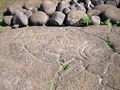
Fish petroglyph found near Ahu Tongariki


Contemporary culture

انظر أيضاً
- Rapa Nui language
- Rapa Nui mythology
- Omphalos
- Mataveri International Airport
- List of megalithic sites
- Podesta (island)
المصادر
- ^ http://www.portalrapanui.cl/rapanui/informaciones.htm
- ^ Pending the enactment of a special charter, the island will continue to be governed as a province of the Valparaíso Region.
ببليوجرافيا مختارة
- ALTMAN, Ann M. 2004. Early Visitors to Easter Island 1864-1877 (translations of the accounts of Eugène Eyraud, Hippolyte Roussel, Pierre Loti and Alphonse Pinart; with an Introduction by Georgia Lee). Los Osos, CA: Easter Island Foundation.
- BARTHEL, Thomas. 1958. Grundlagen zur Entzifferung der Osterinselschrift. Hamburg: Cram, de Gruyter.
- BUTINOV, Nikolai A., & Yuri V. KNOROZOV. 1957. Preliminary Report on the Study of the Written Language of Easter Island. Journal of the Polynesian Society 66. 1.
- Diamond, Jared. 2005. Collapse. How Societies Choose to Fail or Succeed. New York: Viking. ISBN 0-14-303655-6.
- ENGLERT, Sebastian F. 1970. Island at the Center of the World. Translated and Edited by William Mulloy. New York: Charles Scribner's Sons.
- FEDOROVA, Irina K. 1965. Versions of Myths and Legends in Manuscripts from Easter Island. In: Heyerdahl et al. (eds.), Miscellaneous Papers: Reports of the Norwegian Archaeological Expedition to Easter Island and East Pacific 2. 395-401. Stockholm: Forum.
- FISCHER, Steven Roger. 1995. Preliminary Evidence for Cosmogonic Texts in Rapanui’s Rongorongo Inscriptions. Journal of the Polynesian Society 104. 303-21.
- FISCHER, Steven Roger. 1997. Glyph-breaker: A Decipherer's Story. N.Y.: Copernicus/Springer-Verlag.
- FISCHER, Steven Roger. 1997. RongoRongo, the Easter Island Script: History, Traditions, Texts. Oxford and N.Y.: Oxford University Press.
- GUY, Jacques B.M. 1985. On a fragment of the “Tahua” Tablet. Journal of the Polynesian Society 94. 367-87.
- GUY, Jacques B.M. 1988. Rjabchikov’s Decipherments Examined. Journal of the Polynesian Society 97. 321-3.
- GUY, Jacques B.M. 1990. On the Lunar Calendar of Tablet Mamari. Journal de la Société des Océanistes 91:2.135-49.
- HEYERDAHL, Thor. 1965. The Concept of Rongorongo Among the Historic Population of Easter Island. In: Thor Heyerdahl & Edwin N. Ferdon Jr. (eds. and others.), 1961-65. Stockholm: Forum.
- HEYERDAHL, THOR Aku-Aku; The 1958 Expedition to Easter Island.
- HUNT, Terry L. 2006. Rethinking the Fall of Easter Island. American Scientist, 94, 412 (Sept-October 2006)
- HUNTER-ANDERSON, R. 1998. Human vs climatic impacts at Rapa Nui: did the people really cut down all those trees? In:Stevenson, C.M.; Lee, G. & Morin, F.J. (eds): Easter Island in Pacific Context. South Seas Symposium: Proceedings of the Fourth International Conference on Easter Island and East Polynesia: 85–99. Easter Island Foundation.
- LEE, Georgia. 1992. The Rock Art of Easter Island. Symbols of Power, Prayers to the Gods. Los Angeles: The Institute of Archaeology Publications (UCLA).
- MELLÉN BLANCO, Francisco. 1986. Manuscritos y documentos españoles para la historia de la isla de Pascua. Madrid: CEHOPU.
- MÉTRAUX, Alfred. 1940. Ethnology of Easter Island. Bernice P. Bishop Museum Bulletin 160. Honolulu: Bernice P. Bishop Museum Press.
- POZDNIAKOV, Konstantin. 1996. Les Bases du Déchiffrement de l'Écriture de l'Ile de Pâques. Journal de la Societé des Océanistes 103:2.289-303.
- ROUTLEDGE, Katherine. 1919. The Mystery of Easter Island. The story of an expedition. London.
- SHEPARDSON, B. 2006. On the Shoulders of Giants. British Archaeology January/February: 14-17.
- STEADMAN D, (2006). Extinction and Biogeography in Tropical Pacific Birds, University of Chicago Press. ISBN 978-0-226-77142-7
- THOMSON, William J. 1891. Te Pito te Henua, or Easter Island. Report of the United States National Museum for the Year Ending June 30, 1889. Annual Reports of the Smithsonian Institution for 1889. 447-552. Washington: Smithsonian Institution, in Google Books
- VAN TILBURG, Jo Anne. 1994. Easter Island: Archaeology, Ecology and Culture. Washington D.C.: Smithsonian Institution Press.
- VARGAS, Patricia; CRISTINO, Claudio and IZAURIETA, Roberto. 2006. 1000 AÑOS EN RAPA NUI. Arqueologia del Asentamiento. Santiago, Universidad de Chile, Editorial Universitaria. ISBN 956-11-1879-3.
وصلات خارجية
| Easter Island
]].قالب:Austronesian-speaking countries and territories
| مقاطعة پتوركا |  | |
|---|---|---|
| Los Andes Province | ||
| مقاطعة سان فليپى دى أكونكاگوا | ||
| مقاطعة كيوتا | ||
| مقاطعة ڤالپارايسو | ||
| مقاطعة سان أنطونيو | ||
| مقاطعة جزيرة عيد الفصح | ||
| مارگا مارگا | ||
| |||||||||||||
- Pages using gadget WikiMiniAtlas
- Pages using infobox country with unknown parameters
- Pages using infobox UNESCO World Heritage Site with unknown parameters
- Articles with hatnote templates targeting a nonexistent page
- Pages with empty portal template
- دول اوقيانوسية
- Coordinates on Wikidata
- جزيرة القيامة
- Archaeological sites in Chile
- جزر اوقيانوسيا
- Geography of Valparaíso Region
- پولينزيا
- جزر تشيلى