تشاندلر، أريزونا
تشاندلر | |
|---|---|
مدينة | |
 صورة جوية لتشاندلر | |
 Flag  الشعار | |
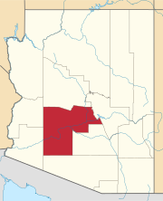
 الموقع في مقاطعة ماريكوپا، أريزونا | |
 تشاندلر الموقع في أريزونا  تشاندلر الموقع في الولايات المتحدة | |
| Coordinates: 33°18′N 111°50′W / 33.300°N 111.833°W | |
| البلد | الولايات المتحدة |
| الولاية | |
| المقاطعة | مقاطعة ماريكوپا |
| التأسيس | 17 مايو 1912 |
| دُمجت | 1920 |
| Government | |
| • Type | مجلس المدينة-العمدة |
| • العمدة | كڤين هارتك [1] |
| Area | |
• Total | 65٫55 ميل² (169٫77 كم²) |
| • Land | 65٫48 ميل² (169٫58 كم²) |
| • Water | 0٫07 ميل² (0٫18 كم²) |
| Elevation | 1٬211 ft (370 m) |
| Population | |
• Total | 275٬987 |
| • Rank | US: رقم 84 |
| • Density | 4٬215٫09/sq mi (1٬627٫45/km2) |
| • صفة المواطنة | تشاندلريون |
| Time zone | UTC−7 (MST (no DST)) |
| الرموز البريدية | 85224–85226, 85246–85249, 85286 |
| Area code | 480 |
| رمز FIPS | 04-12000 |
| GNIS feature ID | 2409433[3] |
| Website | www |
تشاندلر (Chandler)، هي مدينة في مقاطعة ماريكوپا، أريزونا، الولايات المتحدة، وضاحية في منطقة فينكس-مـِسا-تشاندلر الإحصائية الكبرى. تحدها من الشمال والغرب تمپي، ومن الشمال مـِسا، ومن الغرب فينكس، ومن الجنوب تجمع نهر گيلا الهندي، ومن الشرق گلبرت. في تعداد 2020، كان عدد سكان تشاندلر 279.458 نسمة،[4] مرتفعاً عن 236.123 نسمة في تعداد 2010.
التاريخ
In 1891, Dr. Alexander John Chandler, the first veterinary surgeon in Arizona Territory, settled on a ranch south of Mesa and studied irrigation engineering. By 1900, he had acquired 18،000 acre (73 km2) of land and began drawing up plans for a townsite on what was then known as the Chandler Ranch. The townsite office opened on May 16, 1912.
(Soon after celebrating Chandler's Centennial on May 17, 2012, Chandler Museum staff discovered that the city had been celebrating the wrong date.[5] In May 1912, the Chandler Arizonan newspaper had erroneously published the founding day as May 17, and through the years residents had misremembered the correct date, which was Thursday, May 16, 1912.)
The original townsite was bounded by Galveston Street on the north, Frye Road on the south, Hartford Street on the west, and Hamilton Street on the east.[6] By 1913, a town center had become established, featuring the Hotel San Marcos, which also had the first grass golf course in the state. Chandler High School was established in 1914.[7] Chandler incorporated on February 16, 1920, after 186 residents petitioned the Maricopa County Board of Supervisors to approve incorporation. Town founder A.J. Chandler was chosen as the president of the first town council and the town's first mayor.
Most of Chandler's economy was sustained during the Great Depression (though the Depression was to blame for the cancellation of a second San Marcos hotel), but the cotton crash a few years later had a much deeper impact on the city's residents. Later, the founding of Williams Air Force Base in 1941 led to a small surge in population, but Chandler still only held 3,800 people by 1950. By 1980, it had grown to 30,000, and it has since paced the Phoenix metropolitan area's high rate of growth, with suburban residential areas swallowing former agricultural plots. Some of this growth was fueled by the establishment of manufacturing plants for communications and computing firms such as Microchip, Motorola and Intel.
Since the early 1990s, the city of Chandler has experienced exponential growth, ranking among the fastest-growing municipalities in the country. The population had grown to more than 275,000 residents in more than 100,000 homes as of 2020. The heart of Chandler remains its revitalized historic downtown, which includes the Chandler City Hall and the Chandler Center for the Arts. In 2010, Chandler was named an All-America City by the National Civic League. Chandler was the only Arizona winner for the 61st annual awards.[citation needed]
الجغرافيا
According to the United States Census Bureau, Chandler has a total area of 65.5 ميل مربع (170 km2), of which 0.07 ميل مربع (0.18 km2), or 0.11%, are listed as water.[2] The center of the city, along Arizona State Route 87, is 22 ميل (35 km) southeast of Downtown Phoenix.
Chandler has reached its physical limits save for some remaining county islands and cannot expand outward anymore due to being bound in by the Gila River Indian Community, Tempe, Mesa, Gilbert, and Phoenix.
المناخ
| بيانات المناخ لـ تشاندلر، أريزونا | |||||||||||||
|---|---|---|---|---|---|---|---|---|---|---|---|---|---|
| الشهر | ينا | فب | مار | أبر | ماي | يون | يول | أغس | سبت | أكت | نوف | ديس | السنة |
| القصوى القياسية °ف (°س) | 89 (32) |
95 (35) |
99 (37) |
106 (41) |
118 (48) |
116 (47) |
119 (48) |
115 (46) |
113 (45) |
107 (42) |
97 (36) |
86 (30) |
119 (48) |
| متوسط القصوى اليومية °ف (°س) | 67 (19) |
71 (22) |
77 (25) |
85 (29) |
94 (34) |
104 (40) |
106 (41) |
104 (40) |
99 (37) |
89 (32) |
75 (24) |
67 (19) |
87 (30) |
| المتوسط اليومي °ف (°س) | 54 (12) |
58 (14) |
63 (17) |
70 (21) |
78 (26) |
87 (31) |
92 (33) |
90 (32) |
85 (29) |
74 (23) |
61 (16) |
54 (12) |
72 (22) |
| متوسط الدنيا اليومية °ف (°س) | 41 (5) |
45 (7) |
49 (9) |
54 (12) |
61 (16) |
70 (21) |
77 (25) |
76 (24) |
70 (21) |
59 (15) |
47 (8) |
40 (4) |
57 (14) |
| الصغرى القياسية °ف (°س) | 15 (−9) |
19 (−7) |
24 (−4) |
30 (−1) |
37 (3) |
43 (6) |
54 (12) |
51 (11) |
40 (4) |
30 (−1) |
22 (−6) |
17 (−8) |
15 (−9) |
| متوسط تساقط الأمطار inches (mm) | 1.01 (26) |
1.03 (26) |
1.19 (30) |
0.33 (8.4) |
0.17 (4.3) |
0.06 (1.5) |
0.89 (23) |
1.14 (29) |
0.89 (23) |
0.81 (21) |
0.77 (20) |
0.98 (25) |
9.20 (234) |
| Source: The Weather Channel[8] | |||||||||||||
الديموغرافيا
| التعداد | Pop. | ملاحظة | %± |
|---|---|---|---|
| 1930 | 1٬378 | — | |
| 1940 | 1٬239 | −10٫1% | |
| 1950 | 3٬799 | 206٫6% | |
| 1960 | 9٬531 | 150٫9% | |
| 1970 | 13٬763 | 44٫4% | |
| 1980 | 29٬673 | 115٫6% | |
| 1990 | 89٬862 | 202٫8% | |
| 2000 | 176٬581 | 96٫5% | |
| 2010 | 236٬123 | 33٫7% | |
| 2020 | 275٬987 | 16٫9% | |
| U.S. Decennial Census[9] | |||
At the time of the 2010 Census, there were 236,123 people, 86,924 households, and 60,212 families in the city. The racial makeup of the city was 73.3% White, 4.8% Black or African American, 1.5% Native American, 8.2% Asian, 0.2% Pacific Islander, and 8.3% of other races. 21.9% of the population was Hispanic or Latino of any race.[10]
There were 62,377 households, out of which 41.1% had children under the age of 18 living with them, 57.5% were married couples living together, 10.5% had a female householder with no husband present, and 27.2% were non-families. Of all households 19.3% were made up of individuals, and 3.6% had someone living alone who was 65 years of age or older. The average household size was 2.82 and the average family size was 3.26.
In the city, the population was spread out, with 29.8% under the age of 18, 8.6% from 18 to 24, 38.0% from 25 to 44, 17.8% from 45 to 64, and 5.8% who were 65 years of age or older. The median age was 31 years. For every 100 females, there were 99.7 males. For every 100 females age 18 and over, there were 96.9 males.
There were 101,229 housing units as of May 2016.[11] The median income for a household in the city was $70,456, and the median income for a family was $81,720. Males had a median income of $44,578 versus $31,763 for females. The per capita income for the city was $23,904. About 4.6% of families and 6.6% of the population were below the poverty line, including 7.7% of those under age 18 and 8.0% of those age 65 or over.
الاقتصاد
Computer chip manufacturer Intel has an influential role in city growth strategies with four locations in the municipal area, including its first factory to be designated "environmentally sustainable" under current Leadership in Energy and Environmental Design (LEED) criteria.[12] Other high-technology manufacturing firms have partnerships with the local government,[13] their operations employing approximately 25% of non-government workers in 2007.[14] Although per capita employment growth in the sector has been in decline in Arizona since 2000, semiconductor and other electronic component manufacturing was largely unaffected;[15] a series of customized grants for the training of net new employees, incorporating the Phoenix urbanized area (27,000 workers now commute to work in other communities), resulted in a larger market share of (Californian) industry.
Since 2003, more than 2,900 jobs and investments totalling $3 billion have been created along the Price and Santan freeways,[16] in the Price Road Corridor.[17] Three shopping malls provide a "strong attraction" to such an open-ended, high exposure[18] trade area: the 1،300،000-قدم-مربع (120،000 m2) Chandler Fashion Center, opened in 2001, has spurred on several courts and laneway developments.[19] In the southern end of the Corridor, Wal-Mart is expected to draw business from as far south as Hunt Highway, bringing with it a "large consumer population" which will improve "the image and perception of the area" in the mindset of many Greater Phoenix residents and state commercial retailers. The northern portion is "attractive and possesses the historic character" for success, which "can be grown to the south".[20]
Companies headquartered in Chandler include Infusionsoft, Microchip, and Rogers. Bashas' headquarters is in a county island surrounded by Chandler.
كبار أرباب الأعمال
According to the City of Chandler's website[21] leading employers in the city include:
| # | Employer | # of Employees |
|---|---|---|
| 1 | Intel | 12,000 |
| 2 | Wells Fargo | 5,500 |
| 3 | Chandler Unified School District | 4,900 |
| 4 | Bank of America | 3,600 |
| 5 | Chandler Regional Medical Center / Dignity Health | 2,500 |
| 6 | Northrop Grumman | 2,150 |
| 7 | NXP Semiconductors | 1,700 |
| 8 | PayPal | 1,700 |
| 9 | City of Chandler | 1,586 |
| 10 | Microchip Technology | 1,500 |
الثقافة

Chandler is noted for its annual Ostrich Festival.[22] Initially, agriculture was the primary business in Chandler, based on cotton, corn, and alfalfa. During the 1910s, there were ostrich farms in the area, catering to the demand for plumes used in women's hats of the era. This demand ebbed with the increasing usage of the automobile, but the legacy of the ostrich farms would be commemorated by the Ostrich Festival. The Chandler Center for the Arts, a 1,500-seat regional performing arts venue and the Vision Gallery, a non-profit fine arts gallery representing over 300 regional artists in the Chandler[23] area are downtown, and the Arizona Railway Museum is at Tumbleweed Park. A 70،000-قدم-مربع (6،500 m2) Holocaust and Tolerance Museum has been slated for construction in Chandler.[24]
There are numerous properties in the town of Chandler which are considered to be historical and have been included either in the National Register of Historic Places[25] or listed as such by the Chandler Historical Society. The Historic McCullough-Price House, a 1938 Pueblo Revival-style home, was donated to the city by the Price-Propstra family in 2001. The city renovated and opened it to the public in 2007. On June 12, 2009, the McCullough-Price House was added to the National Register of Historic Places, the official listing of America's historic and cultural resources worthy of preservation. The city of Chandler operates the facility, which is southwest of Chandler Fashion Center at 300 S. Chandler Village Dr.
المنتزهات والترفيه

On May 18, 2016, a national nonprofit parks and recreation advocacy organization based in Washington, D.C., announced that Chandler was a 2016 Playful City USA community, marking the tenth consecutive year the city earned the distinction (one of twelve founding U.S. cities to receive the honor for the tenth consecutive year since the program was initiated in 2007).[26] Chandler was recognized for taking an innovative approach to making play a priority throughout the city with its many recreational amenities, parks and aquatic centers.
ادارة الخدمات المجتمعية
The Chandler Community Services Department serves residents and visitors in a variety of ways by providing recreation, fitness, cultural, artistic and educational opportunities along with classes, programs and special events. The Community Services Department, in Old Downtown Chandler, operates the community center, senior center, dozens of local neighborhood and community parks, two recreation centers and six aquatic centers.
Chandler's recreational offerings provide residents and visitors of all ages, interests and abilities with the facilities to participate in many sports, activities and special events. The department publishes a quarterly recreation magazine called Break Time that is distributed free at many City facilities and through a free subscription service to residents.
A sampling of programs available through the Community Services Department and its Parks and Recreation Divisions includes: swim lessons; junior tennis clinics and leagues; youth classes and programs; youth sports; after-school teen programs; summer youth sports camps and arts camps; fitness classes; group aerobics and dance classes; nature and sustainable living courses; adult classes, sports leagues and outdoor recreation programs; active adult activities; therapeutic recreation special events and Special Olympics fundraising programs.
Chandler's regional Tumbleweed Park hosts a variety of events throughout the year, including the annual Ostrich Festival, the Fourth of July Fireworks Festival and the sixth annual Day of Play, attended by more than 5,000 people, was held on Saturday, October 27, 2012, at, Tumbleweed Park.
Veterans Oasis Park is also the site of the city's highest point, at 1،311 أقدام (400 m).[27]
الحكومة

Chandler is represented by a mayor, a vice mayor and five city council members. The vice mayor is elected by the city council from among its members. The mayor, vice mayor and council members represent the entire city and are not elected from districts or wards.
Mayor: Kevin Hartke[1]
Vice Mayor: Matt Orlando[1]
Council Members
- Christine Ellis
- OD Harris
- Mark Stewart
- Jane Poston
- Angel Encinas
التعليم
الابتدائي والثانوي

Most of Chandler is served by the Chandler Unified School District. The area west of Loop 101 is served by the Kyrene Elementary School District and the Tempe Union High School District. The area east of Loop 101 and north of Warner Road is served by Mesa Public Schools. The San Vincente neighborhood in Chandler is served by Gilbert Public Schools.
Education alternatives include charter schools, Christian schools, parochial schools, magnet schools, as well as "traditional" academies. The leading charter schools in Chandler are Basis Schools and Legacy Traditional School.
التعليم العالي
The two-year Chandler-Gilbert Community College, serving 13,000 students, is in the east of the city near the Gilbert border. Private educational institutions Western International University and Apollo Group subsidiary University of Phoenix have locations here. International Baptist College is in Chandler. Arizona State University is 14 ميل (23 km) from downtown in Tempe. Ottawa University began offering adult education programs in Chandler in 1977. Chandler University opened in 2011.
مكتبة تشاندلر العامة
The Chandler Public Library serves Chandler and the greater Phoenix East Valley. The main library is in downtown Chandler, with three branches elsewhere in the city: Sunset, Basha (shared with Basha High School), and Hamilton (shared with Hamilton High School).
As part of a family literacy project to encourage literacy and library use among families who live in public housing, the Chandler Public Library visited four public housing locations to offer a four-week series of programs at each.[28]
تراخيص الإذاعة والتلفزيون
Chandler has only one radio license: KMLE.
النقل
نظام العنونة
Most incorporated portions of Chandler, along with other East Valley cities Gilbert, Mesa, and Tempe, have their own addressing system distinct from the city of Phoenix and Maricopa County. The north–south meridian is Arizona Avenue, also known as State Route 87. Commonwealth Avenue, two blocks south of Chandler Boulevard, is the east–west baseline. With the significant exception of the stretch of the city from Chandler Boulevard to Ray Road, address numbers follow in mile-long increments of 1000 along the grid. Modern remnants of county addressing (which corresponds to the city of Phoenix system) from the city's rural agrarian days can be found in some neighborhood street names (90th place, 132nd Street) and county islands surrounded by the city proper.
المطارات
Chandler Municipal Airport is a two-runway general aviation facility in the heart of the city south of Loop 202. Gila River Memorial Airport in the Gila River Indian Community may serve the city in the future. In western Chandler, Stellar Airpark is a privately owned airport that is open to the public. The nearest commercial airport to downtown Chandler is Phoenix-Mesa Gateway Airport. It is roughly 10 ميل (20 km) to the east and offers service to 35 cities as of July 2015. For international and regional travel, most area residents continue to use Phoenix Sky Harbor International Airport, 20 ميل (30 km) from downtown Chandler.
حافلة المدينة
Chandler has very limited bus service compared with other Valley Metro cities of similar size; it currently ranks sixth in total ridership behind Phoenix, Tempe, Mesa, Scottsdale, and Glendale. Most local routes dead-end a few miles from the city or have further limited service within its borders. Currently, two express bus routes leave from the city near downtown, and a new park and ride facility was completed further south. Faced with increasing congestion, the land-locked city is pursuing transportation alternatives, including enhancement of the local bus system. This goal has partially been achieved through Proposition 400, which converts transit funding from city-based to county-based. The result has been increased frequencies on routes 72, 81, 96 (since July 28, 2008), 112, and 156, as well as Sunday bus service on the 72, 112, and 156. However, other routes have yet to be converted to "supergrid" status.
Freeways
Chandler is served by three limited access highways:
- Loop 202, the Santan Freeway, completed through the city in 2006, cuts through the midsection of the city along the Pecos Road alignment.
- Loop 101, the Price Freeway, was completed in 2001, dividing West Chandler from the rest of the city. A majority of the city's employment, over 10,000 people as of 2007,[29] are along the city's Price Road Corridor. Air Products' industrial pipelines along the corridor are unique to the metropolitan area. South of Pecos, the freeway borders the Gila River Indian Community.
- Interstate 10 is the city's westernmost border, and is on the other side is the Phoenix neighborhood of Ahwatukee.
السكك الحديدية
السكك الحديدية الثقيلة
Chandler is served by two single-track branch lines of the Union Pacific Railroad. One generally traverses the Kyrene Road alignment and currently dead-ends at the Lone Butte Industrial Park. The other runs east of Arizona Avenue and dead-ends near Sacaton, Arizona. Commuter rail service on these lines is under study اعتبارا من 2007[تحديث].
السكك الحديدية الخفيفة
No light rail lines have been approved in the city, although high-capacity corridors including light rail have been identified in other regional and local plans. City officials joined the regional light rail authority, Valley Metro Rail, in 2007, expecting service perhaps in 2020. Potential high capacity transit corridors that have been identified in the past include Rural Road, Arizona Avenue, and Chandler Boulevard. The Chandler General Plan 2016 does not authorize light rail or any form of high capacity transit. A separate process for any consideration of light rail as the mode of transit may occur in the years to come. The language in the General Plan 2016 is to identify that options remain available in the future for the city as it continues analyzing transit within the high-capacity transit corridors.[30]
الرعاية الصحية
The public hospital system, Valleywise Health (formerly Maricopa Integrated Health System), operates Valleywise Community Health Center – Chandler. Its sole hospital, Valleywise Health Medical Center, is in Phoenix.[31]
مشاهير المدينة
_by_Sandro_Halank%E2%80%93111.jpg&filetimestamp=20231214182357&)
- Ryan Bader, MMA fighter
- Cody Bellinger, MLB player for the Chicago Cubs
- Hunter Bishop (born 1998), baseball player
- Jakob Butturff, professional ten-pin bowler
- Zora Folley, professional heavyweight boxer
- Austin Hollins (born 1991), basketball player for Maccabi Tel Aviv of the Israeli Basketball Premier League
- Markus Howard, Marquette all-time leading basketball scorer
- Cameron Jordan, football player for the New Orleans Saints
- Shawn Michaels, professional wrestler and WWE Hall of Famer
- Patrick Murphy, MLB pitcher for the Minnesota Twins
- James Rallison (TheOdd1sOut), YouTube animator
- Chase Lucas, football player for the Detroit Lions
المدن الشقيقة
Chandler has two sister cities:[32]
معرض صور الممتلكات التاريخية
(NRHP = National Register of Historic Places)
(CHS = Chandler Historical Society)[34]
-
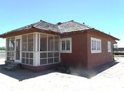
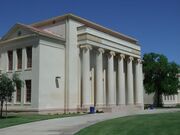 Close-up view of Chandler High School, built in 1900 and at 350 N. Arizona Ave. The building is listed in the National Register of Historic Places (Reference #07000836).
 -
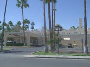 San Marcos Hotel—The grand opening of the Hotel San Marcos took place on November 22, 1913. Among the 500 guests present were Governor George P. Hunt and Vice President Thomas Marshall. National Register of Historic Places – 1982 (Reference #82002078).
 -
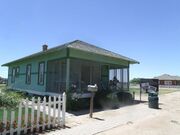
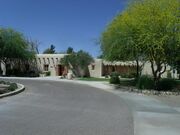 The McCullough-Price House was built in 1925 and is located at 300 S. Chandler Village Dr. near the Chandler Fashion Center. It is on display and is used as one of the buildings of the Chandler Museum, a museum presenting the history of the city. Listed in the National Register of Historic Places (Reference #09000311).
 -
 Suhwaro Hotel built in 1900 and in 58 W. Buffalo St. in Chandler, Arizona. Architectural Style: Mission/Spanish Revival. The building is listed in the National Register of Historic Places (Reference #94000575).
 -
 The Edwards House is the "Maples" model from the 1913 Aladdin Company catalog. The house is at Tumbleweed Park at 2250 S. McQueen Road. It is listed as historic by the Chandler Historical Society.
 -
 The McCroskey House was built by George Edwards in 1917 and was originally near Pecos and Dobson Roads. The house was sold to the McCroskey family and is at Tumbleweed Park at 2250 S. McQueen Road. It is listed as historic by the Chandler Historical Society.
 -
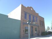 The McCormick Building was built in 1928 and is at 149 West Boston Street. It originally housed the I.O.O.F. (Independent Order of Odd Fellows) Hall and Armory. The building is listed as historical by the Chandler Historical Society.
 -
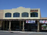
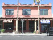 The Monroe Building was built in 1912. The building is at 28 San Marcos Place. The Chamber met upstairs and the lower floors were leased to stores. Merchant E. W. Monroe, after whom the building is named, leased the first floor for the Monroe Hardware Company, Chandler's first hardware company. In 1915, the top floor space was converted into Chandler's first movie theater, where silent pictures were shown. In 1919, the second floor became offices for Chandler's first attorney Arthur E. Price, after whom Price Road is named. The building is listed as historical by the Chandler Historical Society.
 -
 The Hotel Chandler Building was built in 1914. The building is at 98 San Marcos Place. Chandler's first elected mayor, David A. Jacobson, financed the construction of this building. The bottom floor was leased out for stores, and the second story was a reasonably priced hotel, an affordable alternative to the San Marcos Resort. Many prominent Chandler businessmen, especially those working downtown, kept permanent residence in rooms at the Hotel. The building is listed as historical by the Chandler Historical Society.
 -
 The Price Building was built in 1914 and is at 80 S. San Marcos Place. It is named for Arthur E. Price, who owned it at one time. Price, Chandler's first attorney, drafted Chandler's incorporation charter in 1920. Price Road is named after him. The building is listed as historical by the Chandler Historical Society.
 -
 The Dobson Building was built in 1912 and is at 64 S. San Marcos Place. John H. Dobson, who first homesteaded in the Mesa area in the 1890s, was one of the most instrumental men in Chandler's early history, financing many private and public ventures, as well as establishing the First National Bank in 1919. Dobson Road is named after him. The building is listed as historical by the Chandler Historical Society.
 -
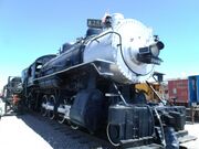 Southern Pacific Railroad Locomotive No. SP 2562 and Tender No. 8365 were built in 1900. It is on exhibit in the Arizona Railway Museum at 330 E. Ryan Rd in Chandler, Arizona. The locomotive is a Model: BLW 2-8-0, built as: SP 2562 (2-8-0) by the Baldwin Locomotive Works, Serial Number: 29064. The locomotive and tender are listed in the National Register of Historic Places (Reference #09000511).


التمثيل الحكومي
الفدرالي
The north central section of the city and the western "leg" of the city are within Arizona's 4th congressional district, served by Representative Greg Stanton, a Democrat. The rest of Chandler is within Arizona's 5th congressional district, served by Representative Andy Biggs, a Republican.
الولائي
Chandler's western "leg" and a small, narrow portion of the adjacent northern part of the city are within Arizona's 18th Legislative District, served by Representatives Denise Epstein and Jennifer Jermaine, and Senator Sean Bowie, all Democrats. The rest of the city is in Arizona's 17th Legislative District, served by Representatives Jennifer Pawlik and Jeff Weninger, and Senator J. D. Mesnard, one Democrat and two Republicans.
انظر أيضاً
المصادر
- ^ أ ب ت "Chandler Mayor and Council | City of Chandler". www.chandleraz.gov. March 21, 2018. Archived from the original on April 28, 2020. Retrieved April 24, 2020.
- ^ أ ب "2021 U.S. Gazetteer Files: Arizona". United States Census Bureau. Retrieved May 6, 2022.
- ^ أ ب U.S. Geological Survey Geographic Names Information System: تشاندلر، أريزونا
- ^ أ ب "Chandler city, Arizona: 2020 DEC Redistricting Data (PL 94-171)". U.S. Census Bureau. Retrieved May 6, 2022.
- ^ "Chandler History: Real story of day city was founded". azcentral (in الإنجليزية). Archived from the original on March 28, 2022. Retrieved 2020-01-28.
- ^ "Driving Chandler's Streets". maricopa.edu. Archived from the original on January 28, 2016. Retrieved June 16, 2015.
- ^ ChandlerAZ.gov, [The Story of Chandler, Arizona http://www.chandleraz.gov/default.aspx?pageid=37 Archived سبتمبر 27, 2007 at the Wayback Machine]. Retrieved October 13, 2009.
- ^ "Average Weather for Chandler, AZ – Temperature and Precipitation". Weather.com. Archived from the original on August 2, 2010. Retrieved August 5, 2010.
- ^ "Census of Population and Housing". Census.gov. Archived from the original on July 1, 2021. Retrieved June 4, 2016.
- ^ Data Access and Dissemination Systems (DADS). "American FactFinder – Results". census.gov. Archived from the original on 2019-05-21.
- ^ Chandler. "Community Profile Demographics" https://www.chandleraz.gov/default.aspx?pageid=724 Archived يونيو 23, 2016 at the Wayback Machine. Retrieved June 21, 2016
- ^ "Intel Company Overview" (PDF). Intel.
- ^ Gonzales, Angela (يناير 2, 2004). "Chandler develops biomed center, adds 270 jobs". Phoenix Business Journal. Archived from the original on يوليو 5, 2004. Retrieved يونيو 2, 2006.
- ^ "Economy of Chandler: January 2008" (PDF). azcommerce.com. Archived (PDF) from the original on July 17, 2008. Retrieved July 29, 2008.
- ^ "High-Technology Activities in Arizona: 2007 Update" (PDF). azcommerce.com. January 2008. Archived (PDF) from the original on July 16, 2008. Retrieved July 29, 2008.
- ^ "Industrial Sites". Chandler Economic Development staff, City of Chandler. Archived from the original on مارس 10, 2005. Retrieved يونيو 2, 2006.
- ^ "Contracts Awarded September 2007 though March 2008, The Acquirer Spring 2008 newsletter, O. R. Colan Associates" (PDF). orcolan.com. Retrieved March 27, 2018.[dead link]
- ^ "Project Methodology: Chapter Three, South Arizona Avenue Entry Corridor Study, City of Chandler" (PDF). chandleraz.gov. Archived from the original (PDF) on August 13, 2017. Retrieved March 27, 2018.
- ^ "Project Methodology: Chapter One, South Arizona Avenue Entry Corridor Study, City of Chandler" (PDF). chandleraz.gov. Archived from the original (PDF) on August 13, 2017. Retrieved March 27, 2018.
- ^ Final Report, South Arizona Avenue Entry Corridor Study Archived أكتوبر 19, 2007 at the Wayback Machine, RNL Design.
- ^ "Chandler's Leading Employers List" (PDF). www.chandleraz.gov. Archived (PDF) from the original on November 8, 2020. Retrieved November 29, 2020.
- ^ "Shake a tail feather, get out to Ostrich Festival". azcentral.com. Archived from the original on March 28, 2022. Retrieved March 14, 2011.
- ^ "Vision Gallery". visiongallery.org/. Archived from the original on October 23, 2019. Retrieved September 10, 2019.
- ^ "Chandler site picked for tolerance museum". azcentral.com. Archived from the original on March 28, 2022. Retrieved January 23, 2011.
- ^ "National Register of Historical Places – ARIZONA (AZ), Maricopa County". nationalregisterofhistoricplaces.com. Archived from the original on May 12, 2013. Retrieved May 12, 2013.
- ^ "Playful City USA Communities". kaboom.org. Archived from the original on July 12, 2018. Retrieved July 11, 2018.
- ^ "Chandler Veterans Oasis Park Map" (PDF). Archived (PDF) from the original on October 28, 2019. Retrieved October 28, 2019.
- ^ "Cultural Inventory Project: Chandler Public Library". cip.lib.az.us. Archived from the original on October 1, 2006. Retrieved March 27, 2018.
- ^ Paterik, Stephanie (May 26, 2005). "Price Corridor ripe for development". Arizona Business Gazette. Archived from the original on March 28, 2022. Retrieved April 14, 2010.
- ^ "Archived copy" (PDF). Archived from the original (PDF) on September 29, 2016. Retrieved October 26, 2016.
{{cite web}}: CS1 maint: archived copy as title (link) - ^ "Locations". Valleywise Health. Archived from the original on December 1, 2021. Retrieved 2021-12-02.
- ^ "Interactive City Directory". Sister-cities.org. Archived from the original on April 16, 2017. Retrieved April 16, 2017.
- ^ "Sister Partnerships by US State – Asia Matters for America". Archived from the original on January 13, 2020. Retrieved January 9, 2020.
- ^ "Historic Structures and Neighborhoods". chandleraz.gov. Archived from the original on March 24, 2014. Retrieved May 12, 2013.
وصلات خارجية
| Find more about تشاندلر، أريزونا at Wikipedia's sister projects | |
| Definitions from Wiktionary | |
| Media from Commons | |
| Quotations from Wikiquote | |
| Source texts from Wikisource | |
| Textbooks from Wikibooks | |
| Travel guide from Wikivoyage | |
| Learning resources from Wikiversity | |
- Official website
- Visit Chandler, official City of Chandler tourism website
مقالات متعلقة بشاندلر، أريزونا | ||||||||||||||||||||||
|---|---|---|---|---|---|---|---|---|---|---|---|---|---|---|---|---|---|---|---|---|---|---|
| ||||||||||||||||||||||
- Pages using gadget WikiMiniAtlas
- Articles with dead external links from November 2018
- Short description is different from Wikidata
- Coordinates on Wikidata
- Articles with unsourced statements from March 2014
- Articles with hatnote templates targeting a nonexistent page
- مقالات فيها عبارات متقادمة منذ 2007
- جميع المقالات التي فيها عبارات متقادمة
- Official website different in Wikidata and Wikipedia
- تشاندلر، أريزونا
- منطقة فينكس الكبرى
- مدن مقاطعة ماريكوپا، أريزونا
- مدن أريزونا
- أماكن مأهولة تأسست في 1912
- بلدات شركات في أريزونا
- أماكن مأهولة في صحراء سونوران
- تأسيسات 1912 في أريزونا