تامبا، فلوريدا
Tampa, Florida | |
|---|---|
 Flag  الشعار | |
| الكنية: | |
 Interactive map of Tampa | |
 Tampa Location in the United States  Tampa Tampa (الولايات المتحدة) | |
| الإحداثيات: 27°56′51″N 82°27′31″W / 27.94750°N 82.45861°W | |
| Country | United States |
| State | Florida |
| County | Hillsborough |
| City | Tampa |
| Settled | 1823 |
| Incorporated (Village) | January 18, 1849 |
| Incorporated (Town) | September 10, 1853 and August 11, 1873 |
| Incorporated (City) | December 15, 1855[أ] and July 15, 1887 |
| الحكومة | |
| • النوع | Strong Mayor–Council |
| • Mayor | Jane Castor (D) |
| • Legislative | Tampa City Council |
| المساحة | |
| • City | 175٫83 ميل² (455٫40 كم²) |
| • البر | 114٫02 ميل² (295٫30 كم²) |
| • الماء | 61٫82 ميل² (160٫10 كم²) 35.3% |
| • الحضر | 968٫9 ميل² (2٬509٫5 كم²) |
| • العمران | 2٬554 ميل² (6٬610 كم²) |
| المنسوب | 48 ft (14٫6 m) |
| التعداد | |
| • City | 384٬959 |
| • Estimate (2021)[5] | 387٬050 |
| • الترتيب | 52nd in the US |
| • الكثافة | 3٬376٫4/sq mi (1٬303٫6/km2) |
| • Urban | 2٬783٬045 (US: 17th) |
| • الكثافة الحضرية | 2٬872٫3/sq mi (1٬109٫0/km2) |
| • العمرانية | 3٬175٬275 (US: 18th) |
| صفة المواطن | Tampan, Tampanian, Tampeño[7] |
| منطقة التوقيت | UTC−5 (EST) |
| • الصيف (التوقيت الصيفي) | UTC−4 (EDT) |
| ZIP codes | 33601–33626, 33629–33631, 33633–33635, 33637, 33646, 33647, 33650, 33655, 33660–33664, 33672–33675, 33677, 33679–33682, 33684–33689, 33694[8] |
| مفتاح الهاتف | 813, 656 |
| FIPS code | 12-71000[9] |
| GNIS feature ID | 0292005[10] |
| الموقع الإلكتروني | www |


_C.jpg&filetimestamp=20230605021607&)


تامپا (/ˈtæmpə/)[11] هي مدينة كبرى، ومقعد مقاطعة هيلزبروف، فلوريدا، الولايات المتحدة.[12] تقع المدينة على الساحل الغربي لفلوريدا في خليج تامپا، بالقرب من خليج المكسيك، وهي أكبر مدينة في منطقة خليج تامپا. في تعداد 2010 وصل عدد سكان المدينة 335.709 نسمة،[9] وفي 2016 وصل عدد سكانها إلى 377.165 نسمة.[13]
Tampa was founded as a military center during the 19th century with the establishment of Fort Brooke. The cigar industry was also brought to the city by Vincente Martinez Ybor, after whom Ybor City is named. Tampa was reincorporated as a city in 1887 following the Civil War. Tampa's economy is driven by tourism, health care, finance, insurance, technology, construction, and the maritime industry.[14] The bay's port is the largest in the state, responsible for over $15 billion in economic impact.[15]
The city is part of the Tampa-St. Petersburg-Clearwater, Florida Metropolitan Statistical Area, which is a four-county area composed of roughly 3.1 million residents,[16] making it the second-largest metropolitan statistical area (MSA) in the state and the sixth largest in the Southeastern United States, behind Dallas-Fort Worth, Houston, Washington D.C., Atlanta, and Miami.[17] The Greater Tampa Bay area has over 4 million residents and generally includes the Tampa and Sarasota metro areas.
أصل الاسم
When the pioneer community living near the US Army outpost of Fort Brooke was incorporated in 1849, it was called "Tampa Town" and the name was shortened to simply "Tampa" in 1855. The earliest instance of the name "Tampa", in the form "Tanpa", appears in the memoirs of Hernando de Escalante Fontaneda, who spent 17 years as a captive of the Calusa and traveled through much of peninsular Florida. He described Tanpa as an important Calusa town to the north of the Calusa domain, possibly under another chief. Archaeologist Jerald Milanich places the town of Tanpa at the mouth of Charlotte Harbor. The entrances to Tampa Bay and Charlotte Harbor are obscured by barrier islands, and their locations, and the names applied to them, were a source of confusion to explorers, surveyors and map-makers from the 16th century through the 18th century. Bahía Tampa and Bahía de Espíritu Santo were each used, at one time or another, for the modern Tampa Bay and Charlotte Harbor.[18][19] Tampa Bay was labeled Bahía de Espíritu Santo (Bay of the Holy Spirit) in the earliest Spanish maps of Florida, but became known as B. Tampa (Bahía Tampa or Tampa Bay) as early as 1576.[20][21] "B. Tampa", corresponding to Tampa Bay, appeared for the first time on a printed map in Antonio de Herrera y Tordesillas's Description del Destricto del Audiencia de la Espanola, from his book Descripcion de las Indias Ocidentales, printed in Madrid in 1601.[22]
A British map of 1705 also shows B. Tampa, with "Carlos Bay" for Charlotte Harbor to the south, while a 1748 British map had "B. del Spirito Santo" for Tampa Bay and, again, "Carlos Bay" to the south. A Spanish map of 1757 renamed Tampa Bay as "San Fernando". As late as 1774, Bernard Romans called Tampa Bay "Bay of Espiritu Santo", with "Tampa Bay" restricted to the Northwest arm (what is now Old Tampa Bay) and the northeast arm named "Hillsborough Bay". The name may have come from the Calusa language or possibly, the Timucua language. Some scholars have compared "Tampa" to "itimpi", which means "close to" or "nearby" in the Creek language, but its meaning is not known.[19]
People from Tampa are generally known as "Tampans", "Tampanians", or "Tampeños".[23] Local authorities consulted by Michael Kruse of the Tampa Bay Times suggest that "Tampan" was historically more common, while "Tampanian" became popular when the former term came to be seen as a potential insult.[24] A mix of Cuban, Italian, and Spanish immigrants began arriving in the late 1800s to found and work in the new communities of Ybor City and West Tampa. By about 1900, these newcomers came to be known as "Tampeños" (or "Tampeñas" for females), a term that is still sometimes used to refer to their descendants living in the area, and potentially, to all residents of Tampa regardless of their ethnic background.[24][25][26][7]
التاريخ
الاستكشاف الأوروپي


السيطرة الأمريكية

الحرب الأمريكية وإعادة الإعمار
الازدهار الاقتصادي في عقد 1880

سكك حديد پلانت

سيجار يبور


أوائل القرن 20
بوليتا والجريمة المنظمة

منتصف-أواخر القرن 20

البيئة الطبيعية

الطبوغرافيا
المناخ
| بيانات المناخ لـ تامپا، فلوريدا (مطار تامپا الدولي)، 1981−2010 normals,[ب] extremes 1890−present[ت] | |||||||||||||
|---|---|---|---|---|---|---|---|---|---|---|---|---|---|
| الشهر | ينا | فب | مار | أبر | ماي | يون | يول | أغس | سبت | أكت | نوف | ديس | السنة |
| القصوى القياسية °ف (°س) | 86 (30) |
88 (31) |
92 (33) |
96 (36) |
98 (37) |
99 (37) |
98 (37) |
98 (37) |
96 (36) |
95 (35) |
92 (33) |
86 (30) |
99 (37) |
| متوسط القصوى اليومية °ف (°س) | 69.9 (21.1) |
72.5 (22.5) |
76.3 (24.6) |
81.0 (27.2) |
87.2 (30.7) |
89.6 (32.0) |
90.1 (32.3) |
90.2 (32.3) |
88.9 (31.6) |
84.3 (29.1) |
78.0 (25.6) |
72.0 (22.2) |
81.7 (27.6) |
| المتوسط اليومي °ف (°س) | 60.8 (16.0) |
63.4 (17.4) |
67.3 (19.6) |
72.0 (22.2) |
78.4 (25.8) |
82.2 (27.9) |
83.0 (28.3) |
83.2 (28.4) |
81.7 (27.6) |
76.2 (24.6) |
69.1 (20.6) |
63.1 (17.3) |
73.4 (23.0) |
| متوسط الدنيا اليومية °ف (°س) | 51.6 (10.9) |
54.4 (12.4) |
58.2 (14.6) |
63.0 (17.2) |
69.7 (20.9) |
74.8 (23.8) |
75.9 (24.4) |
76.2 (24.6) |
74.5 (23.6) |
68.0 (20.0) |
60.3 (15.7) |
54.2 (12.3) |
65.1 (18.4) |
| متوسط الدنيا °ف (°س) | 32.6 (0.3) |
37.0 (2.8) |
41.4 (5.2) |
48.8 (9.3) |
59.6 (15.3) |
68.3 (20.2) |
70.8 (21.6) |
71.7 (22.1) |
67.5 (19.7) |
53.2 (11.8) |
44.6 (7.0) |
36.1 (2.3) |
30.2 (−1.0) |
| الصغرى القياسية °ف (°س) | 21 (−6) |
22 (−6) |
29 (−2) |
38 (3) |
49 (9) |
53 (12) |
63 (17) |
66 (19) |
54 (12) |
40 (4) |
23 (−5) |
18 (−8) |
18 (−8) |
| متوسط تساقط الأمطار inches (mm) | 2.23 (57) |
2.81 (71) |
3.03 (77) |
2.03 (52) |
2.10 (53) |
6.68 (170) |
7.07 (180) |
7.77 (197) |
6.30 (160) |
2.26 (57) |
1.55 (39) |
2.47 (63) |
46.30 (1٬176) |
| Average rainy days (≥ 0.01 inch) | 6.8 | 6.6 | 6.6 | 4.9 | 5.5 | 12.7 | 15.9 | 16.0 | 12.2 | 6.5 | 5.1 | 5.8 | 104.6 |
| متوسط الرطوبة النسبية (%) | 74.9 | 73.0 | 71.8 | 69.0 | 69.8 | 74.4 | 76.6 | 78.4 | 77.6 | 74.2 | 75.0 | 75.0 | 74.1 |
| Mean monthly ساعات سطوع الشمس | 199.9 | 202.7 | 267.5 | 299.1 | 314.5 | 277.8 | 265.3 | 249.5 | 223.0 | 233.9 | 201.7 | 191.6 | 2٬926٫5 |
| نسبة السطوع المحتمل للشمس | 61 | 65 | 72 | 78 | 75 | 67 | 62 | 61 | 60 | 66 | 62 | 60 | 66 |
| Source 1: NOAA (relative humidity and sun 1961−1990)[27][28][29] Weather Channel[30] | |||||||||||||
| Source 2: Tampa Bay Times for April record high[31] | |||||||||||||
|date= January 2012 }}
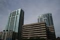
أفق المدينة

الضواحي
العمارة
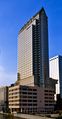
100 North Tampa (1992)
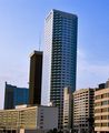
Bank of America Plaza (1986)
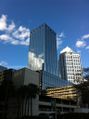
One Tampa City Center (1981)
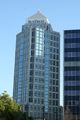
SunTrust Financial Centre (1992)
The Element (2009)
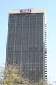
Park Tower (1972)

Rivergate Tower (1988)
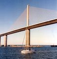
The Sunshine Skyway Bridge (1987)


المعالم


الديموغرافيا
| التعداد | Pop. | ملاحظة | %± |
|---|---|---|---|
| 1850 | 974 | — | |
| 1870 | 796 | — | |
| 1880 | 720 | −9٫5% | |
| 1890 | 5٬532 | 668٫3% | |
| 1900 | 15٬839 | 186٫3% | |
| 1910 | 37٬782 | 138٫5% | |
| 1920 | 51٬608 | 36٫6% | |
| 1930 | 101٬161 | 96�0% | |
| 1940 | 108٬391 | 7٫1% | |
| 1950 | 124٬681 | 15�0% | |
| 1960 | 274٬970 | 120٫5% | |
| 1970 | 277٬714 | 1�0% | |
| 1980 | 271٬523 | −2٫2% | |
| 1990 | 280٬015 | 3٫1% | |
| 2000 | 303٬447 | 8٫4% | |
| 2010 | 335٬709 | 10٫6% | |
| 2016 (تق.) | 377٬165 | [32] | 12٫3% |
| source:[33][34][35][36] | |||
| ديموغرافيا تامپا | |||
|---|---|---|---|
| تعداد 2010 | تامپا | مقاطعة هيلزبروف | فلوريدا |
| إجمالي السكان | 335,709 | 1,229,226 | 18,801,310 |
| السكان، نسبة التغير، 2000 حتى 2010 | +10.6% | +23.1% | +17.6% |
| الكثافة السكانية | 2,960.2/sq ميل | 1,204.9/sq ميل | 350.6/sq ميل |
| بيض أو هسپان (تشمل البيض الهسپان) | 62.9% | 71.3% | 75.0% |
| (Non-Hispanic White or Caucasian) | 46.3% | 53.7% | 57.9% |
| سود أو أفارقة-أمريكان | 26.2% | 16.7% | 16.0% |
| هسپان أو لاتين (من أي عرقية) | 23.1% | 24.9% | 22.5% |
| آسيويون | 3.4% | 3.4% | 2.4% |
| أمريكان أصليون أو آلاسكيون أصليون | 0.4% | 0.4% | 0.4% |
| سكان جزر الهادي أو هاوايون أصليون | 0.1% | 0.1% | 0.1% |
| عرقيتان أخرتان أو أكثر (متعددو العرقيات) | 3.2% | 3.1% | 2.5% |
| آخرون | 3.8% | 5.0% | 3.6% |
الديانات


الاقتصاد


| الشركة | الموظفون | الصناعة |
|---|---|---|
| BayCare Health System | 19,600 | عاية صحية |
| Publix Super Market | 13,800 | بيع تجزئة |
| HCA West Florida | 13,150 | رعاية صحية |
| Frontier Communications | 9,950 | اتصالات |
| Tampa General Hospital | 6,600 | رعاية صحية |
| Wal-Mart | 5,800 | تجارة تجزئة |
| Florida Hospital | 5,100 | رعاية صحية |
| JPMorgan Chase & Co. | 5,000 | مالية |
| Moffitt Cancer Center | 4,300 | رعاية صحية |
| سيتي | 4,000 | مالية |

الفنون والثقافة

الفنون والترفيه

المتاحف


المطبخ

السياحة والترفيه

أحداث


الرياضة
| الفريق | الاتحاد | الملعب | الموسم الأول | البطولات |
|---|---|---|---|---|
| Tampa Bay Buccaneers | NFL | Raymond James Stadium | 1976 | 1 (XXXVII)[38] |
| Tampa Bay Lightning | NHL | Amalie Arena | 1992 | 1 (2004)[39] |
| Tampa Bay Rays | MLB | Tropicana Field (St. Petersburg) | 1998 | 0 |
| Tampa Bay Rowdies | USL | Al Lang Stadium (St. Petersburg) | 1975 (original club), 2010 (current club) | 2* (1975; 2012)[40] |
| Tampa Bay Storm | AFL | Amalie Arena | 1987 (moved to Tampa in 1991) | 5 (V; VII; IX; X; XVII)[41] |
كرة القدم

البيسبول


الهوكي
كرة القدم

الرياضات الجامعية
الحكومة
المطافئ
إنفاذ القانون
التعليم

المدارس الابتدائية والثانوية
المكتبات العامة

التعليم العالي

الإعلام
البنية التحتية

النقل
الطرق


المطارات

السكك الحديدية
الرياضات المائية


النقل العام

الرعاية الصحية

المرافق
مشاهير البلدة
مدن شقيقة
فلوريدا على علاقة شقاقة مع المدن التالية:[42]
|
انظر أيضاً
- Baldomero López
- قائمة المناطق الحضرية في الأمريكتين
- قائمة الفن العام في تامپا، فلوريدا
- قائمة المدن الأمريكية حسب عدد السكان
- خاتم تامپا
الهوامش
- ^ Original city charter revoked by Florida Legislature on October 4, 1869[3]
- ^ Mean monthly maxima and minima (i.e. the highest and lowest temperature readings during an entire month or year) calculated based on data at said location from 1981 to 2010.
- ^ Official records for Tampa were kept at downtown from April 1890 to December 1940, Peter O. Knight Airport from January 1941 to 5 June 1946, and at Tampa Int'l since 7 June 1946. For more information, see ThreadEx
المصادر
- ^ "Ybor City: Cigar Capital of the World". Nps.gov. June 28, 1999. Archived from the original on January 9, 2014. Retrieved July 5, 2013.
- ^ "Alive: Ybor stumbled upon Guavaween". St Petersburg Times. October 29, 1999. Archived from the original on September 24, 2015. Retrieved July 5, 2013.
- ^ "John Thomas Lesley – 12th Mayor of Tampa". Archived يوليو 20, 2010 at the Wayback Machine at TampaGov. Retrieved March 22, 2010.
- ^ "2020 U.S. Gazetteer Files". United States Census Bureau. Archived from the original on March 18, 2021. Retrieved December 2, 2021.
- ^ أ ب "QuickFacts: Tampa city, Florida". census.gov. United States Census Bureau. Retrieved January 22, 2023.
- ^ "List of 2020 Census Urban Areas". census.gov. United States Census Bureau. Retrieved January 8, 2023.
- ^ أ ب Guzzo, Paul (January 10, 2019). "Are you a Tampan, Tampanian or Tampeño?". Tampa Bay Times. Archived from the original on January 21, 2019. Retrieved January 21, 2019.
- ^ "Look Up a Zip Code: TAMPA FL". U.S. Postal Service. Archived from the original on August 7, 2020. Retrieved April 28, 2017.
- ^ أ ب "Geographic Identifiers: 2010 Demographic Profile Data (G001): Tampa city, Florida". American Factfinder. U.S. Census Bureau. Retrieved April 28, 2017.[dead link]
- ^ "Tampa, Florida". نظام معلومات الأسماء الجغرافية، المسح الجيولوجي الأمريكي.
- ^ "Tampa". The American Heritage Dictionary of the English Language. Houghton Mifflin Harcourt. Retrieved December 4, 2011.
- ^ "Find a County". National Association of Counties. Archived from the original on May 31, 2011. Retrieved 2011-06-07.
{{cite web}}: Unknown parameter|deadurl=ignored (|url-status=suggested) (help) - ^ "Annual Estimates of the Resident Population for Incorporated Places: April 1, 2010 to July 1, 2015". Archived from the original on June 2, 2016. Retrieved July 2, 2016.
{{cite web}}: Unknown parameter|deadurl=ignored (|url-status=suggested) (help) - ^ "Development and Economic Opportunity". City of Tampa (in الإنجليزية). July 7, 2014. Archived from the original on May 2, 2021. Retrieved May 2, 2021.
- ^ "Port of Tampa Bay Official Information". Port Tampa Bay (in الإنجليزية). Archived from the original on May 2, 2021. Retrieved May 2, 2021.
- ^ "Tampa-St. Petersburg-Clearwater Metro Area 2019 ACS Estimates". American Community Survey. U.S. Census Bureau. 2019. Archived from the original on May 9, 2021. Retrieved February 25, 2021.
- ^ "table with row headers in column A and column headers in rows 3 through 4 (leading dots indicate sub-parts)". census.gov. Archived from the original (CSV) on 2022-04-16.
- ^ Milanich, Jerald T. (1995). Florida Indians and the Invasion from Europe. Gainesville, Florida: University Press of Florida. p. 40. ISBN 978-0-8130-1360-2.
- ^ أ ب Simpson, J. Clarence (1956). Boyd, Mark F. (ed.). Florida Place-Names of Indian Derivation. Tallahassee, Florida: Florida Geological Survey. pp. 106–109.
- ^ "University of Georgia Libraries, Hargrett Rare Books and Manuscript Library: 1695 Spanish Map". Archived from the original on June 24, 2009. Retrieved April 27, 2009.
- ^ See Juan Lopez de Velasco manuscript map of the West Indies, ca. 1576. John Carter Brown Library, Providence, Rhode Island.
- ^ "Description del Destricto Del Avdiencia Dela Espanola Herrera". luna.tampabayhistorycenter.org. Archived from the original on October 31, 2020. Retrieved October 28, 2020.
- ^ Guzzo, Paul (January 14, 2019). "In the debate over what to call people from Tampa, the Tampeños have spoken". Tampa Bay Times. Tampa Publishing Company. Archived from the original on January 26, 2022. Retrieved January 26, 2022.
- ^ أ ب Kruse, Michael. "What are you called if you live in Tampa?". Tampa Bay Times. Archived from the original on April 26, 2014. Retrieved April 26, 2014.
- ^ Dworkin y Méndez, Kenya C. (2002). "Cuban Theater, American Stage: Before Exile". In Luis, Ramos-García (ed.). The State of Latino Theater in the United States. Psychology Press. pp. 103–104. ISBN 978-0815338802. Archived from the original on February 6, 2021. Retrieved July 16, 2014.
- ^ Hewitt, Nancy A. (1991). "'The Voice of Virile Labor': Labor Militancy, Community Solidarity, and Gender Identity Among Tampa's Latin Workers, 1880–1921". In Baron, Ava (ed.). Work Engendered: Toward a New History of American Labor. Cornell University Press. pp. 142–167. ISBN 978-0801495434. Archived from the original on February 5, 2021. Retrieved July 16, 2014.
- ^ "NowData - NOAA Online Weather Data". National Oceanic and Atmospheric Administration. Retrieved 2016-04-11.
- ^ "Station Name: FL TAMPA INTL AP". National Oceanic and Atmospheric Administration. Retrieved 2014-06-11.
- ^ "WMO Climate Normals for TAMPA/INT'L ARPT FL 1961–1990". National Oceanic and Atmospheric Administration. Retrieved 2014-03-10.
- ^ {{cite web | url = http://www.weather.com/outlook/travel/vacationplanner/wxclimatology/monthly/graph/USFL0481 | title = Average Weather for Tampa, FL - Temperature and Precipitation | publisher = The Weather Channel | accessdate = 2011-10-03
- ^ http://livesite-prd-2.tampabay.com/news/weather/its-not-just-hot-its-record-breaking-hot-in-tampa-bay-for-the-month-of/2322143
- ^ "Population and Housing Unit Estimates". Retrieved June 9, 2017.
- ^ "CENSUS OF POPULATION AND HOUSING (1790–2000)". U.S. Census Bureau. Retrieved 2011-04-11.
- ^ "Tampa (city) QuickFacts from the US Census Bureau". Quickfacts.census.gov. Retrieved July 5, 2013.
- ^ 1850 census population included Fort Brooke, which was located outside the municipal limits.
- ^ Not returned separately by enumerators in 1860.
- ^ Major Employers, Tampa Bay Partnership.
- ^ "Super Bowl XXXVII Box Score: Tampa Bay 48, Oakland 21". www.nfl.com. Retrieved 2017-01-10.
- ^ "2003-04 Tampa Bay Lightning Roster and Statistics | Hockey-Reference.com". Hockey-Reference.com. Retrieved 2017-01-10.
- ^ "History". www.rowdiessoccer.com. Retrieved 2017-01-10.
- ^ "ARENAFOOTBALL.COM - Arena Bowl". www.arenafootball.com. Retrieved 2017-01-10.
- ^ "Tampa Sister Cities from City of Tampa website". Tampagov.net. Archived from the original on October 18, 2007. Retrieved 2011-04-17.
{{cite web}}: Unknown parameter|deadurl=ignored (|url-status=suggested) (help) - ^ "Sister cities of İzmir". Izmir Metropolitan Municipality. Retrieved 2012-10-22.
- ^ Florence, Jeanne. "Le Havre – Les villes jumelées" (in French). Retrieved 2013-08-07.
{{cite web}}: Unknown parameter|trans_title=ignored (|trans-title=suggested) (help)CS1 maint: unrecognized language (link) - ^ "Le Havre – Les villes jumelées" (in French). Archived from the original on July 29, 2013. Retrieved 2013-08-07.
{{cite web}}: Unknown parameter|trans_title=ignored (|trans-title=suggested) (help)CS1 maint: unrecognized language (link)
المراجع
- Brown, Canter (1999). Tampa before the Civil War. Tampa: University of Tampa Press. ISBN 978-1-879852-64-8.
- Brown, Canter (2000). Tampa in Civil War & Reconstruction. Tampa: University of Tampa Press. ISBN 978-1-879852-68-6.
- Cinchett, John (2009). Vintage Tampa Signs and Scenes. Tampa: Arcadia Publishing. ISBN 978-0-7385-6836-2.
- Kerstein, Robert (2001). Politics and Growth in Twentieth-Century Tampa. Gainesville, FL: University Press of Florida. ISBN 0-8130-2083-2.
- Lastra, Frank (2005). Ybor City: the Making of a Landmark Town. Tampa: University of Tampa Press. ISBN 978-1-59732-003-0.
- Milanich, Jerald (1995). Florida Indians and the Invasion from Europe. Gainesville, FL: University Press of Florida. ISBN 0-8130-1360-7.
- Mormino, Gary (1998). The Immigrant World of Ybor City. Gainesville, FL: University Press of Florida. ISBN 978-0-8130-1630-6.
- Pizzo, Anthony (1968). Tampa Town 1824–1886: Cracker Village with a Latin Accent. Tampa, Fl: Hurricane House.
- Pizzo, Anthony (1983). Tampa the Treasure City. Tulsa, OK: Continental Heritage Press. ISBN 978-0-932986-38-2.
- Stewart, George (2008). Names on the Land: a Historical Account of Place-Naming in the United States. New York: NYRB Classics. ISBN 978-1-59017-273-5.
وصلات خارجية
| Find more about تامبا، فلوريدا at Wikipedia's sister projects | |
| Definitions from Wiktionary | |
| Media from Commons | |
| Quotations from Wikiquote | |
| Source texts from Wikisource | |
| Textbooks from Wikibooks | |
| Travel guide from Wikivoyage | |
| Learning resources from Wikiversity | |
- Official website
- Tampa Bay Convention and Visitors Bureau
- Tampa Chamber of Commerce
- Tampa website dedicated to historic Tampa photographs
- Tampa Bay at the Open Directory Project
- Tampa Changing – Historical and modern photographs of Tampa
- National Park Service Battle Description of the Battle of Fort Brooke and Ballast Point
- Pages using gadget WikiMiniAtlas
- Articles with dead external links from April 2020
- CS1 errors: unsupported parameter
- Short description is different from Wikidata
- Articles with hatnote templates targeting a nonexistent page
- Pages using multiple image with auto scaled images
- Pages using infobox settlement with possible nickname list
- Coordinates on Wikidata
- صفحات تستخدم جدول مستوطنة بقائمة محتملة لصفات المواطن
- صفحات تستخدم جدول مستوطنة بقائمة محتملة لمفاتيح الهاتف
- Pages using US Census population needing update
- تامپا، فلوريدا
- مدن فلوريدا
- مدن مقاطعة هيلزبروف، فلوريدا
- مقاعد مقاطعات فلوريدا
- أماكن مأهولة تأسست في 1823
- أماكن مأهولة في خليج تامپا
- مدن موانئ في ساحل خليج الولايات المتحدة
- مدن موانئ في فلوريدا
- تأسيسات 1823 في أراضي فلوريدا
- صفحات مع الخرائط