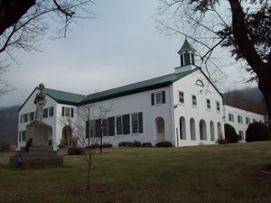
مقاطعة نلسون، ڤرجينيا
Nelson County | |
|---|---|
 | |
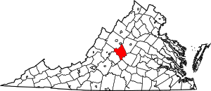
 الموقع ضمن ولاية Virginia | |
 موقع Virginia ضمن الولايات المتحدة | |
| الإحداثيات: 37°47′N 78°53′W / 37.79°N 78.88°W | |
| البلد | |
| State | |
| تأسست | 1807 |
| السمِيْ | Thomas Nelson, Jr. |
| Seat | Lovingston |
| أكبر community | Nellysford |
| المساحة | |
| • الإجمالي | 474 ميل² (1٬230 كم²) |
| • البر | 471 ميل² (1٬220 كم²) |
| • الماء | 3٫5 ميل² (9 كم²) 0.7% |
| التعداد (2010) | |
| • الإجمالي | 15٬020 |
| • Estimate (2018)[1] | 14٬836 |
| • الكثافة | 32/sq mi (12/km2) |
| منطقة التوقيت | UTC−5 (Eastern) |
| • الصيف (التوقيت الصيفي) | UTC−4 (EDT) |
| Congressional district | 5th |
| الموقع الإلكتروني | www |
مقاطعة نيلسون إنگليزية: Nelson County هي إحدى المقاطعات في ولاية فيرجينيا في الولايات المتحدة.
الديمغرافيا
| التعداد | Pop. | ملاحظة | %± |
|---|---|---|---|
| 1810 | 9٬684 | — | |
| 1820 | 10٬137 | 4٫7% | |
| 1830 | 11٬254 | 11�0% | |
| 1840 | 12٬287 | 9٫2% | |
| 1850 | 12٬758 | 3٫8% | |
| 1860 | 13٬015 | 2�0% | |
| 1870 | 13٬898 | 6٫8% | |
| 1880 | 16٬536 | 19�0% | |
| 1890 | 15٬336 | −7٫3% | |
| 1900 | 16٬075 | 4٫8% | |
| 1910 | 16٬821 | 4٫6% | |
| 1920 | 17٬277 | 2٫7% | |
| 1930 | 16٬345 | −5٫4% | |
| 1940 | 16٬241 | −0٫6% | |
| 1950 | 14٬042 | −13٫5% | |
| 1960 | 12٬752 | −9٫2% | |
| 1970 | 11٬702 | −8٫2% | |
| 1980 | 12٬204 | 4٫3% | |
| 1990 | 12٬778 | 4٫7% | |
| 2000 | 14٬445 | 13�0% | |
| 2010 | 15٬020 | 4�0% | |
| 2018 (تق.) | 14٬836 | [1] | −1٫2% |
| U.S. Decennial Census[2] 1790-1960[3] 1900-1990[4] 1990-2000[5] 2010-2015[6] | |||
السياسة
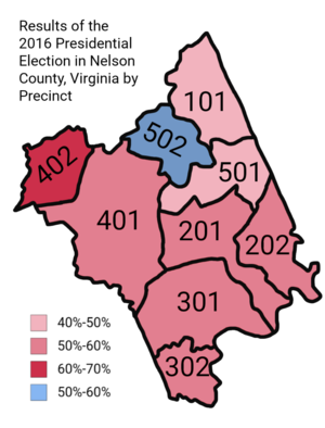
Presidential elections results
| Year | Republican | Democratic | الأحزاب الثالثة |
|---|---|---|---|
| 2016 | 50.0% 4,154 | 44.4% 3,689 | 5.6% 468 |
| 2012 | 47.8% 3,947 | 50.6% 4,171 | 1.6% 132 |
| 2008 | 44.8% 3,647 | 54.0% 4,391 | 1.2% 95 |
| 2004 | 49.6% 3,539 | 49.6% 3,543 | 0.8% 57 |
| 2000 | 47.4% 2,913 | 47.3% 2,907 | 5.3% 325 |
| 1996 | 37.8% 1,988 | 52.9% 2,782 | 9.4% 494 |
| 1992 | 39.0% 2,159 | 46.7% 2,586 | 14.3% 793 |
| 1988 | 51.6% 2,502 | 46.9% 2,272 | 1.6% 75 |
| 1984 | 57.2% 2,777 | 41.6% 2,021 | 1.1% 55 |
| 1980 | 41.5% 1,866 | 53.6% 2,410 | 4.9% 220 |
| 1976 | 37.7% 1,516 | 60.2% 2,426 | 2.1% 85 |
| 1972 | 67.2% 2,145 | 29.9% 954 | 2.9% 92 |
| 1968 | 33.0% 1,130 | 32.7% 1,120 | 34.3% 1,176 |
| 1964 | 35.2% 893 | 64.5% 1,635 | 0.2% 6 |
| 1960 | 34.2% 775 | 65.3% 1,480 | 0.6% 13 |
| 1956 | 37.2% 764 | 59.2% 1,215 | 3.7% 75 |
| 1952 | 37.6% 740 | 62.0% 1,222 | 0.4% 8 |
| 1948 | 21.3% 371 | 69.2% 1,204 | 9.5% 166 |
| 1944 | 23.5% 427 | 76.4% 1,390 | 0.1% 2 |
| 1940 | 20.3% 330 | 79.4% 1,291 | 0.3% 5 |
| 1936 | 23.5% 370 | 76.4% 1,204 | 0.2% 3 |
| 1932 | 14.0% 238 | 85.6% 1,457 | 0.4% 7 |
| 1928 | 33.7% 618 | 66.3% 1,216 | |
| 1924 | 24.5% 350 | 72.8% 1,042 | 2.7% 39 |
| 1920 | 28.7% 392 | 71.2% 973 | 0.2% 2 |
| 1916 | 19.0% 249 | 81.0% 1,063 | |
| 1912 | 16.8% 163 | 72.7% 706 | 10.5% 102 |
انظر أيضاً
المراجع
- ^ أ ب "Population and Housing Unit Estimates". Retrieved July 14, 2019.
- ^ "U.S. Decennial Census". United States Census Bureau. Retrieved January 4, 2014.
- ^ "Historical Census Browser". University of Virginia Library. Retrieved January 4, 2014.
- ^ "Population of Counties by Decennial Census: 1900 to 1990". United States Census Bureau. Retrieved January 4, 2014.
- ^ "Census 2000 PHC-T-4. Ranking Tables for Counties: 1990 and 2000" (PDF). United States Census Bureau. Retrieved January 4, 2014.
- ^ خطأ استشهاد: وسم
<ref>غير صحيح؛ لا نص تم توفيره للمراجع المسماةQF - ^ Leip, David. "Dave Leip's Atlas of U.S. Presidential Elections". uselectionatlas.org.
وصلات خارجية
مشاع المعرفة فيه ميديا متعلقة بموضوع [[commons: Category:Nelson County, Virginia
| Nelson County, Virginia
]].
|
Albemarle County | Augusta County | 
| |
| Rockbridge County | ||||
| Buckingham County | Appomattox County | Amherst County |
الكلمات الدالة:
?
تصنيفات:
- Pages using gadget WikiMiniAtlas
- Short description is different from Wikidata
- Coordinates on Wikidata
- مقاطعات Virginia
- Pages using infobox U.S. county with unknown parameters
- Articles containing إنگليزية-language text
- Pages using Lang-xx templates
- Pages using US Census population needing update
- مقاطعة نلسون، ڤرجينيا
- تأسيسات 1807 في ڤرجينيا
- أماكن مأهولة تأسست في 1807
- مقاطعات على نهر جيمس (ڤرجينيا)
- مقاطعات ڤرجينيا
