مقاطعة لويزا، ڤرجينيا
Louisa County | |
|---|---|
 | |
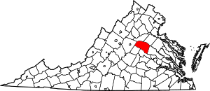
 الموقع ضمن ولاية Virginia | |
 موقع Virginia ضمن الولايات المتحدة | |
| الإحداثيات: 37°59′N 77°58′W / 37.99°N 77.96°W | |
| البلد | |
| State | |
| تأسست | 1742 |
| السمِيْ | Louise of Great Britain |
| Seat | Louisa |
| أكبر town | Louisa |
| المساحة | |
| • الإجمالي | 511 ميل² (1٬320 كم²) |
| • البر | 496 ميل² (1٬280 كم²) |
| • الماء | 15 ميل² (40 كم²) 2.9% |
| التعداد (2010) | |
| • الإجمالي | 33٬153 |
| • Estimate (2018)[1] | 36٬778 |
| • الكثافة | 65/sq mi (25/km2) |
| منطقة التوقيت | UTC−5 (Eastern) |
| • الصيف (التوقيت الصيفي) | UTC−4 (EDT) |
| Congressional district | 7th |
| الموقع الإلكتروني | www |
مقاطعة لويزا إنگليزية: Louisa County هي إحدى المقاطعات في ولاية فيرجينيا في الولايات المتحدة الأمريكية.
التاريخ

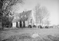
St. John's Chapel, near Boswells Tavern, Louisa County, Historic American Buildings Survey
الجغرافيا
According to the U.S. Census Bureau, the county has a total area of 511 ميل مربع (1،320 km2), of which 496 ميل مربع (1،280 km2) is land and 15 ميل مربع (39 km2) (2.9%) is water.[2]
المقاطعات المجاورة
- Orange County – north
- Spotsylvania County – northeast
- Hanover County – east
- Goochland County – south
- Fluvanna County – southwest
- Albemarle County – west
الطرق السريعة الرئيسية
الديمغرافيا
| التعداد | Pop. | ملاحظة | %± |
|---|---|---|---|
| 1790 | 8٬467 | — | |
| 1800 | 11٬892 | 40٫5% | |
| 1810 | 11٬900 | 0٫1% | |
| 1820 | 13٬746 | 15٫5% | |
| 1830 | 16٬151 | 17٫5% | |
| 1840 | 15٬433 | −4٫4% | |
| 1850 | 16٬691 | 8٫2% | |
| 1860 | 16٬701 | 0٫1% | |
| 1870 | 16٬332 | −2٫2% | |
| 1880 | 18٬942 | 16�0% | |
| 1890 | 16٬997 | −10٫3% | |
| 1900 | 16٬517 | −2٫8% | |
| 1910 | 16٬578 | 0٫4% | |
| 1920 | 17٬089 | 3٫1% | |
| 1930 | 14٬309 | −16٫3% | |
| 1940 | 13٬665 | −4٫5% | |
| 1950 | 12٬826 | −6٫1% | |
| 1960 | 12٬959 | 1�0% | |
| 1970 | 14٬004 | 8٫1% | |
| 1980 | 17٬825 | 27٫3% | |
| 1990 | 20٬325 | 14�0% | |
| 2000 | 25٬627 | 26٫1% | |
| 2010 | 33٬153 | 29٫4% | |
| 2019 (تق.) | 37٬591 | [3] | 13٫4% |
| U.S. Decennial Census[4] 1790–1960[5] 1900–1990[6] 1990–2000[7] 2010–2013[8] | |||
التجمعات
البلدات
Census-designated place
Other unincorporated communities
الأماكن التاريخية والمعالم
- Green Springs Historic District
- Jerdone Castle
- Lake Anna
- Twin Oaks Community, a secular commune, is located in Louisa County.
- Acorn Community another income sharing community in the county, which runs the Southern Exposure Seed Exchange business as its principal source of income.
أشخاص بارزون
- James Waddel Alexander, (1804–1859), born in Louisa County, noted Presbyterian minister and professor at Princeton Theological Seminary [9]
- Arthur P. Bagby, (1794–1858), born in Louisa County, was the tenth Governor of Alabama from 1837 to 1841.
- Henry "Box" Brown (c.1816–after 1889) a slave who escaped to freedom by having himself mailed in a wooden crate to Pennsylvanian abolitionists.
- Paxus Calta, (1957–?) anti-nuclear activist, blogger and member of Twin Oaks Community and Acorn Community
- Dabney Carr, (October 26, 1743 – May 16, 1773), celebrated Louisa County patriot.
- Patrick Henry, (1736–1799), at Roundabout Plantation, eight miles southwest of Louisa Court House, Patrick Henry lived in Louisa County from 1765 to 1768, when he sat for Louisa County in the House of Burgesses. This was the beginning of his political career.[10]
- Charles Henry Langston (1817–1892), born free, one of two men tried and convicted after Oberlin-Wellington Rescue, abolitionist and political activist in Ohio and Kansas.
- John Mercer Langston (1829–1899), abolitionist, activist, educator and politician – in 1855 first black person in Ohio elected to public office, first dean of Howard University law school, first president of Virginia State University, in 1888 first black person to be elected to the United States Congress from Virginia.
- Flora Molton (1908–1990), singer
- John Overton, (1766–1833), born in Louisa County, notable political leader who was an adviser to Andrew Jackson and co-founder of Memphis, Tennessee.
- James Waddel (1739–1805), celebrated Presbyterian preacher
السياسة
نتائج الانتخابات الرئاسية
| Year | Republican | Democratic | Third parties |
|---|---|---|---|
| 2020 | 60.7% 13,294 | 37.7% 8,269 | 1.6% 352 |
| 2016 | 59.8% 10,528 | 35.3% 6,212 | 5.0% 872 |
| 2012 | 56.0% 9,215 | 42.3% 6,953 | 1.7% 284 |
| 2008 | 53.3% 8,182 | 45.5% 6,978 | 1.3% 193 |
| 2004 | 58.9% 7,083 | 40.3% 4,844 | 0.9% 108 |
| 2000 | 54.1% 5,461 | 42.7% 4,309 | 3.2% 326 |
| 1996 | 45.3% 3,768 | 45.2% 3,761 | 9.5% 794 |
| 1992 | 41.7% 3,461 | 40.9% 3,399 | 17.4% 1,447 |
| 1988 | 57.2% 3,831 | 41.6% 2,789 | 1.2% 82 |
| 1984 | 57.9% 3,789 | 41.3% 2,703 | 0.8% 51 |
| 1980 | 46.1% 2,633 | 49.2% 2,809 | 4.6% 264 |
| 1976 | 41.9% 2,151 | 55.6% 2,857 | 2.5% 127 |
| 1972 | 63.6% 2,545 | 33.4% 1,338 | 3.1% 122 |
| 1968 | 38.1% 1,510 | 32.5% 1,290 | 29.4% 1,164 |
| 1964 | 44.1% 1,369 | 55.8% 1,731 | 0.1% 3 |
| 1960 | 47.6% 1,170 | 50.6% 1,244 | 1.8% 44 |
| 1956 | 47.4% 1,152 | 32.7% 795 | 19.8% 482 |
| 1952 | 52.3% 1,135 | 47.2% 1,025 | 0.6% 12 |
| 1948 | 41.5% 701 | 46.2% 782 | 12.3% 208 |
| 1944 | 40.3% 634 | 59.2% 930 | 0.5% 8 |
| 1940 | 38.7% 573 | 60.5% 896 | 0.9% 13 |
| 1936 | 30.4% 486 | 68.8% 1,100 | 0.8% 12 |
| 1932 | 28.6% 366 | 68.6% 879 | 2.8% 36 |
| 1928 | 51.3% 772 | 48.7% 734 | |
| 1924 | 27.0% 282 | 67.6% 707 | 5.5% 57 |
| 1920 | 31.1% 312 | 68.2% 684 | 0.7% 7 |
| 1916 | 26.7% 263 | 72.1% 710 | 1.2% 12 |
| 1912 | 11.1% 91 | 70.5% 578 | 18.4% 151 |
انظر أيضاً
الهامش
- ^ "Population and Housing Unit Estimates". Retrieved July 14, 2019.
- ^ "US Gazetteer files: 2010, 2000, and 1990". United States Census Bureau. 2011-02-12. Retrieved 2011-04-23.
- ^ "Population and Housing Unit Estimates". Retrieved Feb 4, 2021.
- ^ "U.S. Decennial Census". United States Census Bureau. Retrieved January 3, 2014.
- ^ "Historical Census Browser". University of Virginia Library. Retrieved January 3, 2014.
- ^ "Population of Counties by Decennial Census: 1900 to 1990". United States Census Bureau. Retrieved January 3, 2014.
- ^ "Census 2000 PHC-T-4. Ranking Tables for Counties: 1990 and 2000" (PDF). United States Census Bureau. Retrieved January 3, 2014.
- ^ خطأ استشهاد: وسم
<ref>غير صحيح؛ لا نص تم توفيره للمراجع المسماةQF - ^ Who Was Who in America, Historical Volume, 1607–1896. Chicago: Marquis Who's Who. 1963.
- ^ Virginia Historical Markers Archived 2012-06-09 at the Wayback Machine, Virginia Historical Marker W-211: Patrick Henry's Home
- ^ Leip, David. "Dave Leip's Atlas of U.S. Presidential Elections". uselectionatlas.org. Retrieved 2020-12-09.
وصلات خارجية
- Official Louisa County Website
- The Healthy Living Directory
- Louisa County VAGenWeb Genealogy Project
- 2014 Fresh Air piece (audio here) and Atlantic article on a sexting scandal in Louisa County

|
Spotsylvania County | Orange County | 
| |
| Hanover County | Albemarle County | |||
| Goochland County | Fluvanna County |
?
تصنيفات:
- Short description is different from Wikidata
- Pages using gadget WikiMiniAtlas
- مقاطعات Virginia
- Pages using infobox U.S. county with unknown parameters
- Articles containing إنگليزية-language text
- Pages using Lang-xx templates
- Jct template errors
- Pages using US Census population needing update
- مقاطعة لويزا، ڤرجينيا
- تأسيسات 1742 في ڤرجينيا
- منطقة ريتشموند الكبرى
- مقاطعات ڤرجينيا
