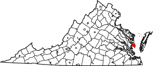
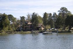
مقاطعة ماثيوز، ڤرجينيا
Mathews County | |
|---|---|
 ميدان محكمة مقاطعة ماثيوز | |
 الموقع ضمن ولاية Virginia | |
 موقع Virginia ضمن الولايات المتحدة | |
| الإحداثيات: 37°25′N 76°17′W / 37.42°N 76.28°W | |
| البلد | |
| State | |
| تأسست | 1791 |
| Seat | Mathews |
| المساحة | |
| • الإجمالي | 252 ميل² (650 كم²) |
| • البر | 86 ميل² (220 كم²) |
| • الماء | 166 ميل² (430 كم²) 65.9%% |
| التعداد (2010) | |
| • الإجمالي | 8٬978 |
| • الكثافة | 110/sq mi (41/km2) |
| منطقة التوقيت | UTC−5 (Eastern) |
| • الصيف (التوقيت الصيفي) | UTC−4 (EDT) |
| Congressional district | 1st |
| الموقع الإلكتروني | www |
مقاطعة ماثيوز إنگليزية: Mathews County هي إحدى المقاطعات في ولاية ڤرجينيا في الولايات المتحدة.
المقاطعات المجاورة
- Middlesex County - north
- Gloucester County - south & west
- York County - south
الديمغرافيا
| التعداد تاريخياً | |||
|---|---|---|---|
| الإحصاء | التعداد | %± | |
| 1800 | 5٬806 | ||
| 1810 | 4٬227 | -27.2% | |
| 1820 | 6٬920 | 63.7% | |
| 1830 | 7٬664 | 10.8% | |
| 1840 | 7٬442 | -2.9% | |
| 1850 | 6٬714 | -9.8% | |
| 1860 | 7٬091 | 5.6% | |
| 1870 | 6٬200 | -12.6% | |
| 1880 | 7٬501 | 21.0% | |
| 1890 | 7٬584 | 1.1% | |
| 1900 | 8٬239 | 8.6% | |
| 1910 | 8٬922 | 8.3% | |
| 1920 | 8٬447 | -5.3% | |
| 1930 | 7٬884 | -6.7% | |
| 1940 | 7٬149 | -9.3% | |
| 1950 | 7٬148 | 0.0% | |
| 1960 | 7٬121 | -0.4% | |
| 1970 | 7٬168 | 0.7% | |
| 1980 | 7٬995 | 11.5% | |
| 1990 | 8٬348 | 4.4% | |
| 2000 | 9٬207 | 10.3% | |
| 2010 | 8٬978 | -2.5% | |
| تقديري 2013 | 8٬897 | -3.4% | |
1790-1960[2] 1900-1990[3] 1990-2000[4] 2010-2013[5] | |||
السياسة
Presidential elections results
| Year | Republican | Democratic | Third parties |
|---|---|---|---|
| 2020 | 67.0% 3,901 | 31.3% 1,825 | 1.7% 100 |
| 2016 | 66.2% 3,517 | 29.4% 1,563 | 4.4% 231 |
| 2012 | 64.9% 3,488 | 33.6% 1,807 | 1.5% 79 |
| 2008 | 63.5% 3,456 | 35.6% 1,934 | 0.9% 50 |
| 2004 | 68.2% 3,497 | 31.0% 1,589 | 0.8% 43 |
| 2000 | 64.0% 2,951 | 32.5% 1,499 | 3.5% 159 |
| 1996 | 51.8% 2,206 | 37.6% 1,602 | 10.6% 452 |
| 1992 | 48.2% 2,179 | 31.0% 1,402 | 20.9% 944 |
| 1988 | 67.5% 2,752 | 30.3% 1,235 | 2.2% 89 |
| 1984 | 71.6% 2,868 | 27.6% 1,106 | 0.8% 31 |
| 1980 | 59.3% 2,204 | 35.0% 1,300 | 5.7% 212 |
| 1976 | 57.8% 1,908 | 39.6% 1,309 | 2.6% 86 |
| 1972 | 72.5% 2,164 | 24.4% 730 | 3.1% 93 |
| 1968 | 47.1% 1,309 | 24.9% 691 | 28.0% 777 |
| 1964 | 50.3% 1,149 | 49.7% 1,137 | |
| 1960 | 61.0% 1,069 | 38.9% 682 | 0.2% 3 |
| 1956 | 65.4% 1,018 | 26.1% 406 | 8.5% 132 |
| 1952 | 63.9% 951 | 35.8% 533 | 0.3% 5 |
| 1948 | 47.5% 490 | 44.4% 458 | 8.1% 83 |
| 1944 | 44.4% 491 | 55.6% 615 | 0.1% 1 |
| 1940 | 36.9% 349 | 62.5% 592 | 0.6% 6 |
| 1936 | 41.9% 452 | 57.7% 622 | 0.5% 5 |
| 1932 | 42.3% 488 | 56.5% 652 | 1.2% 14 |
| 1928 | 66.5% 855 | 33.5% 431 | |
| 1924 | 22.1% 195 | 76.8% 678 | 1.1% 10 |
| 1920 | 25.2% 216 | 72.9% 624 | 1.9% 16 |
| 1916 | 13.8% 90 | 83.9% 549 | 2.3% 15 |
| 1912 | 7.5% 45 | 86.9% 523 | 5.7% 34 |
انظر أيضاً
الهامش
- ^ "U.S. Decennial Census". United States Census Bureau. Retrieved January 3, 2014.
- ^ "Historical Census Browser". University of Virginia Library. Retrieved January 3, 2014.
- ^ "Population of Counties by Decennial Census: 1900 to 1990". United States Census Bureau. Retrieved January 3, 2014.
- ^ "Census 2000 PHC-T-4. Ranking Tables for Counties: 1990 and 2000" (PDF). United States Census Bureau. Retrieved January 3, 2014.
- ^ خطأ استشهاد: وسم
<ref>غير صحيح؛ لا نص تم توفيره للمراجع المسماةQF - ^ Leip, David. "Dave Leip's Atlas of U.S. Presidential Elections". uselectionatlas.org. Retrieved 2020-12-09.
وصلات خارجية

|
Middlesex County | 
| ||
| Chesapeake Bay | Gloucester County | |||
| Gloucester County |
37°25′N 76°17′W / 37.42°N 76.28°W{{#coordinates:}}: لا يمكن أن يكون هناك أكثر من وسم أساسي واحد لكل صفحة
?
تصنيفات:
- Pages using gadget WikiMiniAtlas
- صفحات ذات وسوم إحداثيات غير صحيحة
- Short description is different from Wikidata
- Coordinates on Wikidata
- مقاطعات Virginia
- Articles containing إنگليزية-language text
- Pages using Lang-xx templates
- Virginia counties
- Mathews County, Virginia
- 1791 establishments in the United States
- Hampton Roads
- دول وأقاليم تأسست في 1791
- مقاطعات ڤرجينيا

