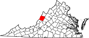
مقاطعة باث، ڤرجينيا
Bath County | |
|---|---|
 الموقع ضمن ولاية Virginia | |
 موقع Virginia ضمن الولايات المتحدة | |
| الإحداثيات: 38°04′N 79°44′W / 38.06°N 79.74°W | |
| البلد | |
| State | |
| تأسست | 1790 |
| السمِيْ | Bath, England |
| Seat | Warm Springs |
| أكبر community | Hot Springs |
| المساحة | |
| • الإجمالي | 535 ميل² (1٬390 كم²) |
| • البر | 529 ميل² (1٬370 كم²) |
| • الماء | 5 ميل² (10 كم²) 1.0%% |
| التعداد | |
| • Estimate (2010) | 4٬731 |
| • الكثافة | 10/sq mi (4/km2) |
| منطقة التوقيت | UTC−5 (Eastern) |
| • الصيف (التوقيت الصيفي) | UTC−4 (EDT) |
| Congressional district | 6th |
| الموقع الإلكتروني | www |
مقاطعة باث إنگليزية: Bath County هي إحدى المقاطعات في ولاية فيرجينيا في الولايات المتحدة الأمريكية.
المقاطعات المجاورة
- Highland County – north
- Augusta County – northeast
- Rockbridge County – east
- Alleghany County – south
- Greenbrier County, West Virginia – southwest
- Pocahontas County, West Virginia – west
المناطق المحمية الوطنية
الطرق الرئيسية
الديمغرافيا
| التعداد تاريخياً | |||
|---|---|---|---|
| الإحصاء | التعداد | %± | |
| 1800 | 5٬508 | ||
| 1810 | 4٬837 | -12.2% | |
| 1820 | 5٬237 | 8.3% | |
| 1830 | 4٬002 | -23.6% | |
| 1840 | 4٬300 | 7.4% | |
| 1850 | 3٬486 | -18.9% | |
| 1860 | 3٬676 | 5.5% | |
| 1870 | 3٬795 | 3.2% | |
| 1880 | 4٬482 | 18.1% | |
| 1890 | 4٬587 | 2.3% | |
| 1900 | 5٬595 | 22.0% | |
| 1910 | 6٬538 | 16.9% | |
| 1920 | 6٬389 | -2.3% | |
| 1930 | 8٬137 | 27.4% | |
| 1940 | 7٬191 | -11.6% | |
| 1950 | 6٬296 | -12.4% | |
| 1960 | 5٬335 | -15.3% | |
| 1970 | 5٬192 | -2.7% | |
| 1980 | 5٬860 | 12.9% | |
| 1990 | 4٬799 | -18.1% | |
| 2000 | 5٬048 | 5.2% | |
| 2010 | 4٬731 | -6.3% | |
| تقديري 2013 | 4٬616 | -8.6% | |
1790-1960[2] 1900-1990[3] 1990-2000[4] 2010-2013[5] | |||
السياسة
| Year | Democrat | الجمهوري |
|---|---|---|
| 2012 | 40.2% 894 | 57.3% 1,274 |
| 2008 | 42.9% 1,043 | 55.5% 1,349 |
| 2004 | 36.3% 828 | 62.8% 1,432 |
| 2000 | 37.2% 822 | 59.3% 1,311 |
| 1996 | 45.0% 922 | 41.3% 847 |
| 1992 | 36.7% 855 | 46.1% 1,075 |
| 1988 | 40.7% 881 | 58.7% 1,273 |
| 1984 | 33.4% 727 | 65.9% 1,434 |
| 1980 | 49.8% 999 | 45.9% 921 |
| 1976 | 53.3% 1,029 | 46.0% 888 |
| 1972 | 28.2% 462 | 68.9% 1,127 |
| 1968 | 26.0% 494 | 46.0% 872 |
| 1964 | 59.9% 770 | 40.1% 516 |
| 1960 | 49.3% 629 | 50.6% 646 |
التجمعات السكنية
Unincorporated communities
Notable residents
- The American educator C. E. Byrd was born in Bath County in 1859.
انظر أيضاً
الهامش
- ^ "U.S. Decennial Census". United States Census Bureau. Retrieved January 1, 2014.
- ^ "Historical Census Browser". University of Virginia Library. Retrieved January 1, 2014.
- ^ "Population of Counties by Decennial Census: 1900 to 1990". United States Census Bureau. Retrieved January 1, 2014.
- ^ "Census 2000 PHC-T-4. Ranking Tables for Counties: 1990 and 2000" (PDF). United States Census Bureau. Retrieved January 1, 2014.
- ^ خطأ استشهاد: وسم
<ref>غير صحيح؛ لا نص تم توفيره للمراجع المسماةQF
وصلات خارجية
الكلمات الدالة:
?
تصنيفات:
- Pages using gadget WikiMiniAtlas
- Short description is different from Wikidata
- مقاطعات Virginia
- U.S. Counties Missing Ex Image
- Articles containing إنگليزية-language text
- Pages using Lang-xx templates
- مقاطعات ڤرجينيا
- Jct template errors
- Coordinates on Wikidata
- مقاطعة باث، ڤرجينيا
- تأسيسات 1790 في الولايات المتحدة
- مقاطعات أپالاشيا