مقاطعة بدفورد، ڤرجينيا
Bedford County | |
|---|---|
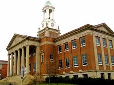
 Bedford County Courthouse | |
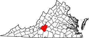
 الموقع ضمن ولاية Virginia | |
 موقع Virginia ضمن الولايات المتحدة | |
| الإحداثيات: 37°19′N 79°32′W / 37.31°N 79.53°W | |
| البلد | |
| State | |
| تأسست | 1754 |
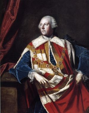
| السمِيْ | John Russell, 4th Duke of Bedford |
| Seat | Bedford |
| أكبر town | Bedford |
| المساحة | |
| • الإجمالي | 769 ميل² (1٬990 كم²) |
| • البر | 753 ميل² (1٬950 كم²) |
| • الماء | 16 ميل² (40 كم²) 2.1%% |
| التعداد (2010) | |
| • الإجمالي | 68٬676 |
| • الكثافة | 96٫5/sq mi (37٫26/km2) |
| منطقة التوقيت | UTC−5 (Eastern) |
| • الصيف (التوقيت الصيفي) | UTC−4 (EDT) |
| Congressional districts | 5th، 6th |
| الموقع الإلكتروني | www |
مقاطعة بدفورد إنگليزية: Bedford County هي إحدى المقاطعات في ولاية فيرجينيا في الولايات المتحدة الأمريكية.
History
The Piedmont area had long been inhabited by indigenous peoples. At the time of European encounter, mostly Siouan-speaking tribes lived in this area.
الجغرافيا
According to the U.S. Census Bureau, the county has a total area of 769 ميل مربع (1،990 km2), of which 753 ميل مربع (1،950 km2) is land and 16 ميل مربع (41 km2) (2.1%) is water.[1]
المقاطعات المجاورة والمدينة
- Rockbridge County – north
- Amherst County – northeast
- Lynchburg, Virginia – east
- Campbell County – southeast
- Pittsylvania County – south
- Franklin County – southwest
- Roanoke County – west
- Botetourt County – northwest
المناطق المحمية الوطنية
- Blue Ridge Parkway (part)
- Jefferson National Forest (part)
- James River Face Wilderness (part)
State Park
الطرق الرئيسية
الديمغرافيا
| التعداد | Pop. | ملاحظة | %± |
|---|---|---|---|
| 1790 | 10٬531 | — | |
| 1800 | 14٬125 | 34٫1% | |
| 1810 | 16٬148 | 14٫3% | |
| 1820 | 19٬305 | 19٫6% | |
| 1830 | 20٬246 | 4٫9% | |
| 1840 | 20٬203 | −0٫2% | |
| 1850 | 24٬080 | 19٫2% | |
| 1860 | 25٬068 | 4٫1% | |
| 1870 | 25٬327 | 1�0% | |
| 1880 | 31٬205 | 23٫2% | |
| 1890 | 31٬213 | 0�0% | |
| 1900 | 30٬356 | −2٫7% | |
| 1910 | 29٬549 | −2٫7% | |
| 1920 | 30٬669 | 3٫8% | |
| 1930 | 29٬091 | −5٫1% | |
| 1940 | 29٬687 | 2�0% | |
| 1950 | 29٬627 | −0٫2% | |
| 1960 | 31٬028 | 4٫7% | |
| 1970 | 26٬728 | −13٫9% | |
| 1980 | 34٬927 | 30٫7% | |
| 1990 | 45٬656 | 30٫7% | |
| 2000 | 60٬371 | 32٫2% | |
| 2010 | 68٬676 | 13٫8% | |
| 2013 (تق.) | 69٬825 | 1٫7% | |
1790-1960[3] 1900-1990[4] 1990-2000[5] 2010-2013[6] | |||
الحكم
مجلس المشرفين
District 1: Bill Thomasson (R)
District 2: Curry W. Martin (R)
District 3: Steve Wilkerson (R)
District 4: John Sharp (R)
District 5: Steve Arrington (R)
District 6: Annie Pollard (I)
District 7: Tammy F. Parker (R)
Constitutional Officers
Clerk of the Circuit Court: Cathy C. Hogan (I)
Commissioner of the Revenue: Faye Eubank (I)
Commonwealth's Attorney: Randy C. Krantz (I)
Sheriff: Michael J. "Mike" Brown (R)
Treasurer: Rebecca C. "Becky" Jones (R)
الاقتصاد
Historically, Bedford County was an agricultural economy. While agriculture is still an important factor in the county's economy, Bedford County has significant residential development to serve Lynchburg, Roanoke, and Smith Mountain Lake. Tourism and retail are also becoming more significant with some new industry near Forest and New London.
السياسة
| Year | GOP | DEM | Others |
|---|---|---|---|
| 2008 | 68.2% 24,420 | 30.7% 11,017 | 1.1% 393 |
| 2004 | 69.8% 21,925 | 29.0% 9,102 | 1.2% 377 |
| 2000 | 65.9% 17,224 | 31.2% 8,160 | 2.9% 765 |
| 1996 | 54.1% 11,955 | 35.2% 7,786 | 10.7% 2,368 |
| 1992 | 50.6% 10,496 | 32.7% 6,792 | 16.7% 3,468 |
| 1988 | 65.3% 10,702 | 33.0% 5,406 | 1.7% 274 |
| 1984 | 68.2% 10,371 | 31.2% 4,754 | 0.6% 92 |
| 1980 | 55.8% 6,608 | 39.9% 4,721 | 4.3% 511 |
| 1976 | 45.3% 4,189 | 51.5% 4,766 | 3.1% 291 |
| 1972 | 73.4% 5,286 | 20.9% 1,501 | 5.7% 412 |
| 1968* | 35.8% 2,807 | 20.1% 1,574 | 45.1% 3,459 |
| 1964 | 48.1% 3,806 | 51.5% 4,076 | 0.4% 32 |
| 1960 | 47.9% 2,911 | 51.8% 3,150 | 0.2% 20 |
*Bedford voted for George Wallace, an Independent for President in 1968.
المعالم
- Beale ciphers, the key to a supposed treasure buried somewhere in the county and which has attracted treasure hunters since the 19th century
- National D-Day Memorial
- Peaks of Otter
- Poplar Forest
- Smith Mountain Lake
المجتمعات
البلدة
المجتمعات غير المشهرة
انظر أيضاً
الهامش
- ^ "US Gazetteer files: 2010, 2000, and 1990". United States Census Bureau. 2011-02-12. Retrieved 2011-04-23.
- ^ "U.S. Decennial Census". United States Census Bureau. Retrieved January 1, 2014.
- ^ "Historical Census Browser". University of Virginia Library. Retrieved January 1, 2014.
- ^ "Population of Counties by Decennial Census: 1900 to 1990". United States Census Bureau. Retrieved January 1, 2014.
- ^ "Census 2000 PHC-T-4. Ranking Tables for Counties: 1990 and 2000" (PDF). United States Census Bureau. Retrieved January 1, 2014.
- ^ خطأ استشهاد: وسم
<ref>غير صحيح؛ لا نص تم توفيره للمراجع المسماةQF
وصلات خارجية
- Bedford Area Chamber of Commerce's website
- Bedford County government's website
- Bedford Genealogical Society's website

|
Amherst County | Rockbridge County | Botetourt County | 
|
| City of Lynchburg, Virginia | Roanoke County | |||
| Campbell County | Pittsylvania County | Franklin County |
- Pages using gadget WikiMiniAtlas
- Short description is different from Wikidata
- مقاطعات Virginia
- Articles containing إنگليزية-language text
- Pages using Lang-xx templates
- Jct template errors
- Pages using US Census population needing update
- Coordinates on Wikidata
- Virginia counties
- Bedford County, Virginia
- 1754 establishments
- Counties on the James River (Virginia)
- Lynchburg metropolitan area
- مقاطعات ڤرجينيا

