إريتريا (اليونان)
Eretria
Ερέτρια | |
|---|---|
 | |
| الإحداثيات: 38°23′N 23°47′E / 38.383°N 23.783°E | |
| البلد | |
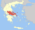
| المنطقة الادارية | Central Greece |
| الوحدة المحلية | Euboea |
| المساحة | |
| • البلدية | 168٫56 كم² (65٫08 ميل²) |
| • الوحدة البلدية | 58٫65 كم² (22٫64 ميل²) |
| المنسوب | 8 m (26 ft) |
| التعداد (2011)[1] | |
| • البلدية | 13٬053 |
| • كثافة البلدية | 77/km2 (200/sq mi) |
| • الوحدة البلدية | 6٬330 |
| • كثافة الوحدة البلدية | 110/km2 (280/sq mi) |
| منطقة التوقيت | UTC+2 (EET) |
| • الصيف (التوقيت الصيفي) | UTC+3 (EEST) |
| Postal code | 340 08 |
| مفتاح الهاتف | 22290 |
| Vehicle registration | ΧΑ |
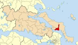
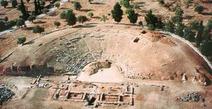
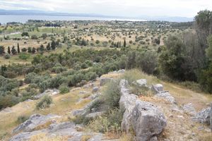
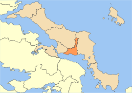
إريتريا (/əˈriːtriə/; باليونانية: Ερέτρια, Eretria, literally "city of the rowers") هي بلدة في إففويا في اليونان، facing the coast of Attica across the narrow South Euboean Gulf. It was an important Greek polis in the 6th/5th century BC, mentioned by many famous writers and actively involved in significant historical events. Excavations of the ancient city began in the 1890s and have been conducted since 1964 by the Greek Archaeological Service (11th Ephorate of Antiquities) and the Swiss School of Archaeology in Greece.[2].
يبلغ عدد سكانها حوالي 3020 نسمة.
التاريخ
الفترة من العتيقة إلى الرومانية
The oldest archaeological finds date the foundation of the city to the 9th century BC. It was probably founded as the harbour of Lefkandi, which is located 15 km to the west. The name comes from the Greek ἐρέτης, erétēs, rower, and the verb ἐρέσσειν/ἐρέττειν, eréssein/eréttein, to row, which makes Eretria the "City of the Rowers". Eretria's population and importance increased at the same time as Lefkandi began to decline in importance from c. 825 BC onwards. The natural superiority of Eretria's harbour and the importance of trade to the Euboeans is one explanation for this gradual population migration from Lefkandi to Eretria.
The earliest surviving mention of Eretria was by Homer (Iliad 2.537), who listed Eretria as one of the Greek cities which sent ships to the Trojan War. In the 8th century BC, Eretria and her near neighbour and rival, Chalcis, were both powerful and prosperous trading cities. Eretria controlled the Aegean islands of Andros, Tenos and Ceos. They also held territory in Boeotia on the Greek mainland. Eretria was also involved in the Greek colonisation and founded the colonies of Pithekoussai and Cumae in Italy together with Chalcis.
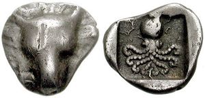
At the end of the 8th century BC, however, Eretria and Chalcis fought a prolonged war (known mainly from the account in Thucydides as the Lelantine War) for control of the fertile Lelantine plain. Little is known of the details of this war, but it is clear that Eretria was defeated. The city was destroyed and Eretria lost her lands in Boeotia and her Aegean dependencies. Neither Eretria nor Chalcis ever again counted for much in Greek politics. As a result of this defeat, Eretria turned to colonisation. She planted colonies in the northern Aegean, on the coast of Macedon, in Italy and Sicily.
الفترة المقدونية
From 318-312BC King Cassander lived at Eretria[3] and commissioned the painter Philoxenus of Eretria to paint the battle of Issus,[4][5] of which the famous Alexander Mosaic[6] in the Naples museum is a copy[7] and the wall paintings in Phillip's tomb at Vergina are connected.
From 304BC Demetrius I granted the city partial autonomy. During this time the city was governed by Menedemos who founded the Eretrian school of philosophy. After the Chremonidean War (267-262BC) a permanent Macedonian garrison was installed.
الفترة الرومانية
In 198 BC in the Second Macedonian War Eretria was plundered by the Romans. The admiral Lucius Quinctius Flamininus was joined by the allied fleets of Attalus I of Pergamon and of Rhodes, and used them in besieging Eretria. He eventually took the town during a night-time assault during which the citizens surrendered. Flamininus came away with a large collection of art works as his share of the booty.[8]
Eretria became an object of contention between the Romans and Macedonians, but was given partial independence and experienced a new period of prosperity. Under the Romans, athletic contests for children and youths called the Romaia were held.
In 87 BC it was finally destroyed in the First Mithridatic War and gradually declined further.
التعداد على مر التاريخ
| Year | Town | Municipal unit | Municipality |
|---|---|---|---|
| 1981 | 3,711 | - | - |
| 1991 | 3,022 | 4,987 | - |
| 2001 | 3,156 | 5,969 | - |
| 2011 | 4,166 | 6,330 | 13,053 |
Notable people
- Achaeus, tragic playwright
- Menedemus (345/4-261/0 BC), Greek philosopher
- Philoxenus (4th century BC), painter
See also
== المراجع ==
- ^ أ ب "Απογραφή Πληθυσμού - Κατοικιών 2011. ΜΟΝΙΜΟΣ Πληθυσμός" (in اليونانية). Hellenic Statistical Authority.
- ^ http://www.unil.ch/esag ESAG
- ^ Eretria, Ministry of Culture, ISBN 960-214-136-0
- ^ Pliny: Natural History xxxv. 10, 36
- ^ Kleiner, Fred S. (2008). Gardner's Art Through the Ages: A Global History. Cengage Learning. p. 142. ISBN 0-495-11549-5.
- ^ Alexander Mosaic by Dr. Beth Harris and Dr. Steven Zucker, Smarthistory, 2013
- ^ Pliny the Elder, XXXV, 110
- ^ Smith, William, Dictionary of Greek and Roman Biography and Mythology, Vol II (1867)
للاستزادة
- ESAG, Eretria. A guide to the ancient city, Infolio éditions, Gollion, 2004. ISBN 2-88474-112-7
- ESAG, ERETRIA Series, Excavations and researches
- Keith G. Walker, "Archaic Eretria. A Political and Social History from the Earliest Times to 490 BC", Routledge, London, 2004.
وصلات خارجية
- ESAG - Eretria The Swiss School Website of the excavations at Eretria
- Perseus – Eretria Links to resources about ancient Eretria
- Greek Ministry of Culture
- Eretria Ferry boats
- Eretria Dream island beach photo
- Eretria photo by night
- Photos of Eretria
- Ministry of Culture and Sports
- Pages using gadget WikiMiniAtlas
- CS1 اليونانية-language sources (el)
- Short description is different from Wikidata
- Coordinates on Wikidata
- Pages using infobox Greece place with unknown parameters
- Articles containing Greek-language text
- Ancient Eretria
- Cities in ancient Greece
- Municipalities of Central Greece
- Populated places established in 1824
- أماكن مأهولة سابقاً في اليونان
- Populated places in Euboea
- أعضاء العصبة الدلية
- مدن اليونان

