ووستر، مساتشوستس
ووستر، مساتشوستس
Worcester, Massachusetts | |
|---|---|
| مدينة ووستر | |
       Clockwise from top: The Worcester Skyline, the American Antiquarian Society, Worcester Union Station, Bancroft Tower, Paul Revere Road, a triple-decker house on Catharine Street, and City Hall | |
 Flag  الشعار | |
| الكنية: The City of the Seven Hills, The Heart of the Commonwealth, Wormtown, Woo-town, The Woo | |
 الموقع ضمن مقاطعة ووستر | |
 ووستر Location within Massachusetts  ووستر Location within the United States | |
| الإحداثيات: 42°16′17″N 71°47′56″W / 42.27139°N 71.79889°W | |
| البلد | الولايات المتحدة |
| الولاية | مساتشوستس |
| المقاطعة | ووستر |
| المنطقة | نيو إنگلاند |
| البلدان التاريخية | مملكة إنگلترة مملكة بريطانيا العظمى |
| المستعمرات التاريخية | مستعمرة خليج مساتشوستس نيو إنگلاند دومنيون مقاطعة خليج مساتشوستس |
| استوطنت | 1673 |
| Incorporated as a town | 14 يونيو 1722 |
| Iأشهرت كمدينة | 29 فبراير 1848 |
| السمِيْ | ووستر، ووسترشاير |
| الحكومة | |
| • النوع | Council–manager |
| • مدير المدينة | Edward M. Augustus Jr. (د) |
| • Mayor | Joseph Petty (د) |
| المساحة | |
| • مدينة | 38٫45 ميل² (99٫57 كم²) |
| • البر | 37٫36 ميل² (96٫77 كم²) |
| • الماء | 1٫08 ميل² (2٫81 كم²) |
| المنسوب | 480 ft (146 m) |
| التعداد (2010) | |
| • مدينة | 181٬045 |
| • Estimate (2019)[2] | 185٬428[1] |
| • الكثافة | 4٬963٫01/sq mi (1٬916٫25/km2) |
| • العمرانية | 923٬672 |
| منطقة التوقيت | UTC−5 (Eastern) |
| • الصيف (التوقيت الصيفي) | UTC−4 (Eastern) |
| ZIP code | 01601–01610, 01612–01615, 01653–01655 |
| مفتاح الهاتف | 508 / 774 |
| FIPS code 0 | 25-82000 |
| GNIS feature ID | 0617867 |
| GDP | $45.393131 billion (as of 2018, in 2012 US chained dollars)[3] |
| GDP per capita | $45,528 per person[3][4] |
| الموقع الإلكتروني | www |
ووستر (Worcester ؛ /ˈwʊstər/ (![]() استمع) WUUS-tər)[5] هي مدينة في، ومقر، مقاطعة ووستر، مساتشوستس، الولايات المتحدة. مسماة على اسم Worcester, ووسترشاير, إنگلترة، as of the 2010 Census the city's population was 181,045,[6] making it the second-most populous city in New England after Boston.[أ] Worcester is approximately 40 ميل (64 km) west of Boston, 50 ميل (80 km) east of Springfield and 40 ميل (64 km) north-northwest of Providence. Due to its location near the geographic center of Massachusetts, Worcester is known as the "Heart of the Commonwealth;" a heart is the official symbol of the city.
استمع) WUUS-tər)[5] هي مدينة في، ومقر، مقاطعة ووستر، مساتشوستس، الولايات المتحدة. مسماة على اسم Worcester, ووسترشاير, إنگلترة، as of the 2010 Census the city's population was 181,045,[6] making it the second-most populous city in New England after Boston.[أ] Worcester is approximately 40 ميل (64 km) west of Boston, 50 ميل (80 km) east of Springfield and 40 ميل (64 km) north-northwest of Providence. Due to its location near the geographic center of Massachusetts, Worcester is known as the "Heart of the Commonwealth;" a heart is the official symbol of the city.
Worcester developed as an industrial city in the 19th century due to the Blackstone Canal and rail transport, producing machinery, textiles and wire. Large numbers of European immigrants made up the city's growing population. However, the city's manufacturing base waned following World War II. Long-term economic and population decline was not reversed until the 1990s, when higher education, medicine, biotechnology, and new immigrants started to make their mark. The city's population has grown by 15% since 1980, and it has experienced urban renewal.
Modern Worcester is known for its diversity and large immigrant population, with significant communities of Vietnamese, Brazilians, Albanians, Puerto Ricans, Ghanaians, Dominicans, and others.[8] 22% of Worcester's population was born outside the United States.[9] A center of higher education, it is home to eight separate colleges and universities, including Holy Cross, Worcester Polytechnic Institute (WPI), and Clark University. Architecturally, Worcester is notable for its large number of 19th century triple-decker houses, Victorian-era mill architecture, and lunch car diners such as Miss Worcester.
Worcester is the principal city of Central Massachusetts, and is a regional government, employment and transportation hub. Since the 1970s, and especially after the construction of Interstates 495, 290, and 395, both Worcester and its surrounding towns have become increasingly integrated with Boston's suburbs. The Worcester region now marks the western periphery of the Boston-Worcester-Providence (MA-RI-NH) U.S. Census Combined Statistical Area (CSA), or Greater Boston.
التاريخ

الجغرافيا
Worcester has a total area of 38.6 ميل مربع (100 km2), 37.6 ميل مربع (97 km2) of land and 1.0 ميل مربع (2.6 km2) (roughly 2.59%) of water. Worcester is bordered by the towns of Auburn, Grafton, Holden, Leicester, Millbury, Paxton, Shrewsbury, and West Boylston.
Worcester is known as the Heart of the Commonwealth, because of its proximity to the center of Massachusetts. The city is about 40 ميل (64 km) غرب بوسطن, 50 ميل (80 km) east of Springfield, and 38 ميل (61 km) northwest of Providence, Rhode Island.
| بيانات المناخ لـ Worcester Regional Airport (elevation 1،000 أقدام (300 m)), 1991–2020 normals, extremes 1892–الحاضر | |||||||||||||
|---|---|---|---|---|---|---|---|---|---|---|---|---|---|
| الشهر | ينا | فب | مار | أبر | ماي | يون | يول | أغس | سبت | أكت | نوف | ديس | السنة |
| القصوى القياسية °ف (°س) | 67 (19) |
71 (22) |
84 (29) |
91 (33) |
94 (34) |
98 (37) |
102 (39) |
99 (37) |
99 (37) |
91 (33) |
79 (26) |
72 (22) |
102 (39) |
| متوسط القصوى اليومية °ف (°س) | 32.3 (0.2) |
35.1 (1.7) |
43.0 (6.1) |
55.7 (13.2) |
66.6 (19.2) |
74.5 (23.6) |
79.8 (26.6) |
78.1 (25.6) |
70.7 (21.5) |
58.9 (14.9) |
47.9 (8.8) |
37.5 (3.1) |
56.7 (13.7) |
| المتوسط اليومي °ف (°س) | 24.7 (−4.1) |
27.0 (−2.8) |
34.5 (1.4) |
46.1 (7.8) |
56.7 (13.7) |
65.2 (18.4) |
70.8 (21.6) |
69.3 (20.7) |
61.9 (16.6) |
50.6 (10.3) |
40.2 (4.6) |
30.5 (−0.8) |
48.1 (8.9) |
| متوسط الدنيا اليومية °ف (°س) | 17.1 (−8.3) |
18.9 (−7.3) |
26.0 (−3.3) |
36.5 (2.5) |
46.8 (8.2) |
55.9 (13.3) |
61.7 (16.5) |
60.5 (15.8) |
53.2 (11.8) |
42.2 (5.7) |
32.5 (0.3) |
23.4 (−4.8) |
39.6 (4.2) |
| متوسط الدنيا °ف (°س) | −2 (−19) |
1 (−17) |
9 (−13) |
25 (−4) |
36 (2) |
45 (7) |
54 (12) |
52 (11) |
40 (4) |
29 (−2) |
18 (−8) |
7 (−14) |
−4 (−20) |
| الصغرى القياسية °ف (°س) | −19 (−28) |
−24 (−31) |
−6 (−21) |
9 (−13) |
27 (−3) |
33 (1) |
41 (5) |
38 (3) |
27 (−3) |
19 (−7) |
3 (−16) |
−17 (−27) |
−24 (−31) |
| متوسط تساقط الأمطار inches (mm) | 3.52 (89) |
3.26 (83) |
4.19 (106) |
4.08 (104) |
3.56 (90) |
4.22 (107) |
3.93 (100) |
4.14 (105) |
4.24 (108) |
4.84 (123) |
4.00 (102) |
4.28 (109) |
48.26 (1٬226) |
| متوسط هطول الثلج inches (cm) | 18.2 (46) |
21.2 (54) |
13.7 (35) |
1.9 (4.8) |
0.0 (0.0) |
0.0 (0.0) |
0.0 (0.0) |
0.0 (0.0) |
0.0 (0.0) |
1.1 (2.8) |
1.9 (4.8) |
14.9 (38) |
72.9 (185) |
| Average precipitation days (≥ 0.01 in) | 12.2 | 10.9 | 12.4 | 12.6 | 13.2 | 11.8 | 11.0 | 10.3 | 9.5 | 11.5 | 10.8 | 12.2 | 138.4 |
| Source: NOAA[10][11][12] | |||||||||||||
الأحياء
معرص صور
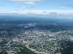
Worcester and the surrounding areas in 2006, looking north from 3،700 أقدام (1،100 m). Route 146 can be seen under construction.
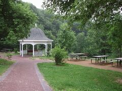
Dodge Park
Washburn Shops, 1868
Cristoforo Colombo Park
Cristoforo Colombo Park


الديمغرافيا
| التعداد | Pop. | ملاحظة | %± |
|---|---|---|---|
| 1790 | 2٬095 | — | |
| 1800 | 2٬411 | 15٫1% | |
| 1810 | 2٬577 | 6٫9% | |
| 1820 | 2٬962 | 14٫9% | |
| 1830 | 4٬173 | 40٫9% | |
| 1840 | 7٬497 | 79٫7% | |
| 1850 | 17٬049 | 127٫4% | |
| 1860 | 24٬960 | 46٫4% | |
| 1870 | 41٬105 | 64٫7% | |
| 1880 | 58٬291 | 41٫8% | |
| 1890 | 84٬655 | 45٫2% | |
| 1900 | 118٬421 | 39٫9% | |
| 1910 | 145٬986 | 23٫3% | |
| 1920 | 179٬754 | 23٫1% | |
| 1930 | 195٬311 | 8٫7% | |
| 1940 | 193٬694 | −0٫8% | |
| 1950 | 203٬486 | 5٫1% | |
| 1960 | 186٬587 | −8٫3% | |
| 1970 | 176٬572 | −5٫4% | |
| 1980 | 161٬799 | −8٫4% | |
| 1990 | 169٬759 | 4٫9% | |
| 2000 | 172٬648 | 1٫7% | |
| 2010 | 181٬045 | 4٫9% | |
| 2019 (تق.) | 185٬428 | [2] | 2٫4% |
| source:[13] | |||
الدخل
Data is from the 2015–2019 American Community Survey 5-Year Estimates.[14][15][16]
| الترتيب | الرمز البريدي (ZCTA) | Per capita income |
Median household income |
Median family income |
التعداد | عدد العائلات |
|---|---|---|---|---|---|---|
| مساتشوستس | $43,761 | $81,215 | $103,126 | 6,850,553 | 2,617,497 | |
| مقاطعة ووستر | $37,574 | $74,679 | $96,393 | 824,772 | 309,951 | |
| 1 | 01602 | $36,792 | $64,942 | $87,092 | 22,900 | 9,498 |
| 2 | 01606 | $35,354 | $65,708 | $82,592 | 19,896 | 8,159 |
| الولايات المتحدة | $34,103 | $62,843 | $77,263 | 324,697,795 | 120,756,048 | |
| 3 | 01609 | $31,337 | $45,992 | $84,844 | 21,628 | 7,859 |
| 4 | 01604 | $29,183 | $55,665 | $66,482 | 38,191 | 14,825 |
| ووستر | $27,884 | $48,139 | $63,893 | 185,143 | 71,595 | |
| 5 | 01607 | $25,319 | $39,928 | $66,875 | 8,167 | 3,702 |
| 6 | 01603 | $24,415 | $42,904 | $56,630 | 19,731 | 7,327 |
| 7 | 01605 | $23,003 | $40,390 | $46,641 | 28,533 | 10,673 |
| 8 | 01610 | $18,452 | $33,695 | $39,928 | 22,023 | 7,729 |
| 9 | 01608 | $17,598 | $31,384 | $30,077 | 4,471 | 1,916 |
الحكومة
قالب:Worcester County politicians
السياسة


Robert Stoddard, owner of The Telegram and Gazette، كان أحد مؤسسي جمعية جون بيرش.
Sixties era radical Abbie Hoffman was born in Worcester in 1936 and spent more than half of his life in the city.
#3333FF #E81B23 #DDDDBB #FED105| Voter registration and party enrollment as of October 19, 2016 – Worcester[17] | |||||
|---|---|---|---|---|---|
| الحزب | عدد المصوتين | النسبة | |||
| الديمقراطي | 44,656 | 44.75% | |||
| الجمهوري | 8,583 | 8.22% | |||
| غير مدرج | 49,487 | 47.37% | |||
| Political Designations | 0 | 0% | |||
| الإجمالي | 107,686 | 100% | |||
الاقتصاد
By the mid-19th century Worcester was one of New England's largest manufacturing centers. The city's large industries specialized in machinery, wire production, and power looms. Although manufacturing has declined, the city still maintains large manufactures, like Norton Abrasives, which was bought by Saint-Gobain in 1990, Morgan Construction Company, since bought by Siemens and then bought by Japanese company PriMetals Technologies, and the David Clark Company. The David Clark Company pioneered aeronautical equipment including anti-gravity suits and noise attenuating headsets.

Services, particularly education and healthcare, make up a large portion of the city's economy. Worcester's many colleges and universities make higher education a considerable presence in the city's economy. Hanover Insurance was founded in 1852 and retains its headquarters in Worcester. Unum Insurance and Fallon Community Health Plan have offices in the city. Polar Beverages is the largest independent soft-drink bottler in the country and is in Worcester.

Worcester is home to the largest concentration of digital gaming students in the United States.[18] The Memorial Auditorium, built as a tribute to World War I veterans of Worcester, is undergoing a renovation and may cater to these Digital Students as a future multimedia and digital center, in conjunction with the twelve Worcester colleges and universities.
As one of the top ten emerging hubs for tech startups,[19] the city's biotechnology and technology industries have helped spur major expansions at both the University of Massachusetts Medical School and Worcester Polytechnic Institute. The Massachusetts Biotechnology Research Park hosts many innovative companies including Advanced Cell Technology and AbbVie. The Worcester Foundation for Experimental Biology in nearby Shrewsbury developed the oral contraceptive pill in 1951.
Downtown Worcester used to boast major Boston retailers Filene's and Jordan Marsh as well Worcester's own department stores Barnard's and Denholm & McKay. Over time most retailers moved away from downtown and into the suburban Auburn Mall and Greendale Mall in North Worcester.
In 2010,[20] the median household income was $61,212. Median family income was $76,485. The per capita income was $29,316. About 7.7% of families and 10.8% of the population were below the poverty line, including 14.1% of those under age 18 and 7.5% of those age 65 or over. In October 2013, Worcester was found to be the number five city for investing in a rental property.[21]
أكبر أرباب العمل
According to the city's 2018 Comprehensive Annual Financial Report,[22] the top ten employers in the city are:
| # | رب العمل | # الموظفين |
|---|---|---|
| 1 | UMass Memorial Health Care | 13,745 |
| 2 | City of Worcester | 5,473 |
| 3 | University of Massachusetts Medical School | 4,172 |
| 4 | Reliant Medical Group | 2,680 |
| 5 | Saint Vincent Hospital | 2,450 |
| 6 | Hanover Insurance | 1,800 |
| 7 | Saint-Gobain | 1,652 |
| 8 | Seven Hills Foundation | 1,445 |
| 9 | Worcester Polytechnic Institute | 1,283 |
| 10 | Community Healthlink | 1,200 |
Education

الثقافة

المدن الشقيقة
Worcester has the following sister cities:[24]
 Worcester, United Kingdom (1998)
 Afula, Israel
 Piraeus, Greece (2005)
 Pushkin, Saint Petersburg, Russia (1987)
انظر أيضاً
ملاحظات
- ^ The third largest city is Providence, Rhode Island, with a population of 178,042.[7]
الهامش
- ^ "U.S. Census Bureau QuickFacts: Worcester city, Massachusetts". United States Census Bureau. Archived from the original on March 21, 2021. Retrieved November 25, 2020.
- ^ أ ب "Population and Housing Unit Estimates". Archived from the original on July 26, 2019. Retrieved May 21, 2020.
- ^ أ ب "Total Real Gross Domestic Product for Worcester, MA-CT (MSA)". Federal Reserve Bank of St. Louis. يناير 2001. Archived from the original on December 27, 2017. Retrieved November 25, 2020.
- ^ In 2012 chained US dollars. Calculated on the basis of the 2018 GDP figure, with the 2010 census-recorded population. Formula:
45.393131*10**9/181045. - ^ How do you say 'Worcester?', http://offices.holycross.edu/studentlife/worcester/about/say, retrieved on August 1, 2015
- ^ "Profile of General Population and Housing Characteristics: 2010 Demographic Profile Data (DP-1): Worcester city, Massachusetts". U.S. Census Bureau, American Factfinder. Archived from the original on February 12, 2020. Retrieved March 6, 2013.
- ^ "Geographic Identifiers: 2010 Demographic Profile Data (G001): Providence city, Rhode Island". U.S. Census Bureau, American Factfinder. Archived from the original on February 10, 2020. Retrieved March 6, 2013.
- ^ Welker, Grant (2018-11-12). "Coming to Worcester: The city's immigrant population has shifted in the last decade". Worcester Business Journal (in الإنجليزية الأمريكية). Retrieved 2021-03-21.
{{cite web}}: CS1 maint: url-status (link) - ^ Welker, Grant (2018-11-12). "City of Immigrants: Foreign-born residents have unusually large impact on Worcester's economy". Worcester Business Journal (in الإنجليزية الأمريكية). Retrieved 2021-03-21.
{{cite web}}: CS1 maint: url-status (link) - ^ "NowData – NOAA Online Weather Data". National Oceanic and Atmospheric Administration. Retrieved May 30, 2021.
- ^ "Threaded Extremes". Archived from the original on March 5, 2020. Retrieved November 9, 2010.
- ^ "Station: Worchester RGNL AP, MA". U.S. Climate Normals 2020: U.S. Monthly Climate Normals (1991-2020). National Oceanic and Atmospheric Administration. Retrieved May 30, 2021.
- ^ "CENSUS OF POPULATION AND HOUSING (1790–2000)". U.S. Census Bureau. Archived from the original on April 26, 2015. Retrieved March 9, 2012.
- ^ "SELECTED ECONOMIC CHARACTERISTICS 2015–2019 American Community Survey 5-Year Estimates". U.S. Census Bureau. Archived from the original on May 3, 2021. Retrieved May 3, 2021.
- ^ "ACS DEMOGRAPHIC AND HOUSING ESTIMATES 2015–2019 American Community Survey 5-Year Estimates". U.S. Census Bureau. Archived from the original on May 4, 2021. Retrieved May 3, 2021.
- ^ "HOUSEHOLDS AND FAMILIES 2015–2019 American Community Survey 5-Year Estimates". U.S. Census Bureau. Archived from the original on May 4, 2021. Retrieved May 3, 2021.
- ^ "The Commonwealth of Massachusetts: Enrollment Breakdown as of October 19, 2016 (pg 18)" (PDF). Massachusetts Elections Division. Archived (PDF) from the original on November 13, 2020. Retrieved January 25, 2017.
- ^ "Wall & Main: Worcester's rising as a startup hub". Archived from the original on November 13, 2020. Retrieved February 15, 2018.
- ^ "The next start-up hubs". Archived from the original on November 13, 2020. Retrieved May 3, 2018.
- ^ "American FactFinder". United States Census Bureau. Archived from the original on February 13, 2016. Retrieved April 14, 2012.
- ^ Novinson, Michael. " Index: Central Mass. #5 in U.S. For Owning Rental Property." Worcester Business Journal. October 8, 2013.
- ^ "City of Worcester 2018 Comprehensive Annual Financial Report" (PDF). worcesterma.gov. Archived (PDF) from the original on November 13, 2020. Retrieved 26 February 2019.
- ^ DPW Parks, Recreation & Cemetery – Salisbury Park Archived يوليو 28, 2010 at the Wayback Machine.
- ^ "Sister Cities Directory: Worcester, Massachusetts". Sister Cities Intl. Retrieved June 20, 2017.
وصلات خارجية
قالب:Worcester Nav قالب:Blackstone Valley قالب:Worcester County, Massachusetts
- Pages using gadget WikiMiniAtlas
- CS1 maint: url-status
- CS1 الإنجليزية الأمريكية-language sources (en-us)
- Short description is different from Wikidata
- Pages using infobox settlement with possible nickname list
- Coordinates on Wikidata
- Pages including recorded pronunciations
- Articles with hatnote templates targeting a nonexistent page
- Pages using US Census population needing update
- Official website different in Wikidata and Wikipedia
- ووستر، مساتشوستس
- مدن مساتشوستس
- مدن في مقاطعة ووستر، مساتشوستسد
- County seats in Massachusetts
- أماكن مأهولة تأسست في 1673
- تأسيسات 1673 في مساتشوستس
- Worcester, MA–CT metropolitan area