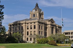
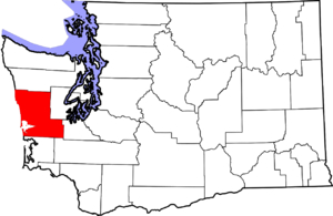
مقاطعة گرايز هاربر، واشنطن
مقاطعة گرايز هاربر | |
|---|---|
 محكمة مقاطعة گرايز هاربر | |
 الموقع ضمن ولاية واشنطن | |
| ملف:واشنطن in United States.svg موقع واشنطن ضمن الولايات المتحدة | |
| الإحداثيات: 47°09′N 123°50′W / 47.15°N 123.83°W | |
| البلد | |
| State | |
| تأسست | 14 أبريل, 1854 |
| السمِيْ | گرايز هاربر |
| Seat | مونتسانو |
| أكبر مدينة | أبردين |
| المساحة | |
| • الإجمالي | 2٬224 ميل² (5٬760 كم²) |
| • البر | 1٬902 ميل² (4٬930 كم²) |
| • الماء | 322 ميل² (830 كم²) 14%% |
| التعداد | |
| • Estimate (2015) | 71٬122 |
| • الكثافة | 37/sq mi (14/km2) |
| منطقة التوقيت | UTC−8 (Pacific) |
| • الصيف (التوقيت الصيفي) | UTC−7 (PDT) |
| Congressional district | 6th |
| الموقع الإلكتروني | www |
مقاطعة گرايز هاربر إنگليزية: Grays Harbor County هي إحدى مقاطعات ولاية واشنطون في الولايات المتحدة الأمريكية.
الجغرافيا
سمات جغرافية
|
|
منتزهات ولائية
- Griffiths-Priday Ocean State Park
- Lake Sylvia State Park
- Ocean City State Park
- Pacific Beach State Park
- Twin Harbors State Park
- Westhaven State Park
- Westport Light State Park
الطرق السريعة الرئيسية
المقاطعات المجاورة
- Jefferson County - north
- Mason County - northeast
- Thurston County - east/southeast
- Lewis County - south/southeast
- Pacific County - south
الأماكن المحمية الوطنية
- Chehalis Indian Reservation
- Colonel Bob Wilderness
- Copalis National Wildlife Refuge
- Grays Harbor National Wildlife Refuge
- Olympic National Forest (part)
- Olympic National Park (part)
- Quinault Indian Reservation
الديمغرافيا
| التعداد | Pop. | ملاحظة | %± |
|---|---|---|---|
| 1860 | 285 | — | |
| 1870 | 401 | 40٫7% | |
| 1880 | 921 | 129٫7% | |
| 1890 | 9٬249 | 904٫2% | |
| 1900 | 15٬124 | 63٫5% | |
| 1910 | 35٬590 | 135٫3% | |
| 1920 | 44٬745 | 25٫7% | |
| 1930 | 59٬982 | 34٫1% | |
| 1940 | 53٬166 | −11٫4% | |
| 1950 | 53٬644 | 0٫9% | |
| 1960 | 54٬465 | 1٫5% | |
| 1970 | 59٬553 | 9٫3% | |
| 1980 | 66٬314 | 11٫4% | |
| 1990 | 64٬175 | −3٫2% | |
| 2000 | 67٬194 | 4٫7% | |
| 2010 | 72٬797 | 8٫3% | |
| 2015 (تق.) | 71٬122 | [1] | −2٫3% |
| U.S. Decennial Census[2] 1790–1960[3] 1900–1990[4] 1990–2000[5] 2010–2015[6] | |||
السياسة
| السنة | الجمهوريون | الديمقراطيون |
|---|---|---|
| 2016 | 48.1% 14,044 | 41.1% 11,998 |
| 2012 | 41.2% 11,914 | 55.1% 15,960 |
| 2008 | 41.5% 12,104 | 56.0% 16,354 |
| 2004 | 46.1% 12,871 | 52.2% 14,583 |
| 2000 | 43.2% 11,225 | 51.2% 13,304 |
| 1996 | 29.1% 7,635 | 53.6% 14,082 |
| 1992 | 25.3% 6,904 | 46.3% 12,599 |
| 1988 | 37.9% 8,860 | 60.3% 14,097 |
| 1984 | 44.0% 11,286 | 54.7% 14,050 |
| 1980 | 40.2% 10,226 | 44.4% 11,290 |
| 1976 | 39.6% 9,464 | 56.4% 13,478 |
| 1972 | 45.6% 10,839 | 49.6% 11,786 |
| 1968 | 34.0% 7,720 | 59.4% 13,480 |
| 1964 | 24.9% 5,744 | 74.5% 17,145 |
| 1960 | 41.9% 10,067 | 57.4% 13,773 |
Grays Harbor County was one of the most consistently Democratic in the nation. Until 2016, the last Republican Presidential candidate to carry the county was Herbert Hoover in 1928[8] and the last Republican gubernatorial candidate to carry the county was Daniel J. Evans in 1964.[9] However, Donald Trump carried the county in the 2016 Presidential Election.
In the United States House of Representatives Grays Harbor is part of Washington's 6th congressional district, which has a Cook Partisan Voting Index of D+5 and is represented by Derek Kilmer. In the Washington State Legislature it lies in the 19th, 24th, and 35th districts. In the Washington State Senate it is represented by Brian Hatfield, James Hargrove, and Tim Sheldon. In the Washington House of Representatives it is represented by Brian Blake, Fred Finn, Kathy Haig, Lynn Kessler, Dean Takko, and Kevin Van De Wege. All of these politicians are of the Democratic Party.[10]
الاقتصاد
The principal economic activities are
- Wood and Paper Products
- Seafood Processing
- Food Processing
- Manufacturing
التجمعات السكنية
المدن
- Aberdeen
- Cosmopolis
- Elma
- Hoquiam
- McCleary
- Montesano (county seat)
- Oakville
- Ocean Shores
- Westport
أماكن مذكورة في التعداد
Other unincorporated communities
أبرز الأشخاص
- Robert Arthur, actor
- Elton Bennett, artist
- Gail Brown, actress
- Trisha Brown, choreographer
- Mark Bruener, NFL player
- Daniel Bryan, professional wrestler
- Robert Eugene Bush, Medal of Honor recipient
- Kurt Cobain, musician
- Colin Cowherd, ESPN Radio host (The Herd with Colin Cowherd)
- Dale Crover, musician
- Reuben H. Fleet, aviation pioneer
- Clarence Chesterfield Howerton, circus performer
- Jerry Lambert, actor
- Robert Motherwell, artist
- Peter Norton, software developer (Norton Utilities)
- Krist Novoselic, musician
- Buzz Osborne, musician
- Douglas Osheroff, Nobel-winning physicist
- Patrick Simmons, musician
- Kurt Vanderhoof, musician
انظر أيضاً
الهامش
- ^ "County Totals Dataset: Population, Population Change and Estimated Components of Population Change: April 1, 2010 to July 1, 2015". Retrieved July 2, 2016.[dead link]
- ^ "U.S. Decennial Census". United States Census Bureau. Archived from the original on May 11, 2015. Retrieved January 7, 2014.
{{cite web}}: Unknown parameter|deadurl=ignored (|url-status=suggested) (help) - ^ "Historical Census Browser". University of Virginia Library. Retrieved January 7, 2014.
- ^ "Population of Counties by Decennial Census: 1900 to 1990". United States Census Bureau. Retrieved January 7, 2014.
- ^ "Census 2000 PHC-T-4. Ranking Tables for Counties: 1990 and 2000" (PDF). United States Census Bureau. Retrieved January 7, 2014.
- ^ خطأ استشهاد: وسم
<ref>غير صحيح؛ لا نص تم توفيره للمراجع المسماةQF - ^ Leip, David. "Dave Leip's Atlas of U.S. Presidential Elections".
- ^ "Presidential election of 1928 - Map by counties".
- ^ David Leip's Election Atlas
- ^ "Washington State Legislature district map".
وصلات خارجية
- Official website
- Harborpedia
- Maritime Heritage Network, an online directory of maritime history resources in the Pacific Northwest, including the Grays Harbor cities of Aberdeen and Hoquiam.
- Pages using gadget WikiMiniAtlas
- Articles with dead external links from March 2017
- CS1 errors: unsupported parameter
- Short description is different from Wikidata
- Coordinates on Wikidata
- مقاطعات واشنطن
- Pages using infobox U.S. county with a missing map
- Articles containing إنگليزية-language text
- Pages using Lang-xx templates
- Pages using US Census population needing update
- Pages using div col with unknown parameters
- مقاطعات ولاية واشنطن
- Grays Harbor County, Washington
- 1854 establishments in Washington Territory
- Populated places established in 1854
- Western Washington