زيلع
زيلع
Zeila | |
|---|---|
بلدة | |
| الإحداثيات: 11°21′14″N 43°28′23″E / 11.35389°N 43.47306°E | |
| البلد | |
| المنطقة | أودل |
| المقاطعة | مقاطعة زيلع |
| تأسست | حوالي القرن الأول الميلادي |
| التعداد (2012) | |
| • الإجمالي | 18٬600[1] |
| منطقة التوقيت | UTC+3 (EAT) |
| Climate | BWh |
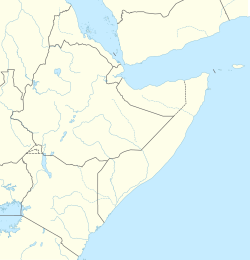
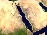
زيلع (بالصومالية: Saaylac) هي بلدة ميناء تاريخي صومالي في خليج عدن في إقليم أودل، في أرض الصومال. وهي محاطة بالماء من ثلاث جهات كما تتميز هذه المدينة على أنها تملك مخزون جيد من الماء العذب وهو ما جعلها ميناء مفضل للجميع قبل تدميرها.[2]
التاريخ
عرفت زيلع كإحدى ممالك الطراز الاسلامي وذلك في القرن السادس عشر وهي مدينة قديمة فقد ذكرها اليعقوبي في كتابه البلدان وذلك في عام 891 م . وكذلك ذكرها المسعودي في كتابه مروج الذهب ومدن الجواهر 935 م وكذلك ابن حوقل ذكرها على انها ميناء يربط إثيوبيا باليمن و الحجاز في كتابه صورة الأرض. وكانت منطقة تجارية كما ذكر الادريسي و ابن سعد وكانت تجارة الرقيق من أهم الموارد عندهم.
كما قام الرحالة ابن بطوطة بزيارتها ولكن لم تعجبه زيلع فكما قال كانت رائحة الذباح تغطي المدينة مما حداه إلى الاقامة في ريف زيلع وذلك في عام 1329 م .
وكانت زيلع منطقة حكم عائلة ولسمح الذي كان يحكم ايضا أفات ولاحقا في القرن الرابع عشر أصبحت زيلع تحت حكم السلطان سعد الدين.
وقام بعدها البرتغال 1517 إلى ان طردهم أهالي المنطقة السمرون سعيد وأقاموا سلطنة زيلع من جديد برعاية الدولة العثمانية .
في عام 1535 قام الامام الغازي أحمد الأشول بحكم السلطنة وكانت في أوجها وقوتها وكذلك حجمها الكبير كل ذلك. الى استنجد الأحباش بالبرتغال وهزم الامام في معركة استشهد فيها الكثير من المجاهدين.
التاريخ الحديث
تم تدمير زيلع بالكامل على يد البرتغال وذلك في عصر الأوجاس ـ وهجر أهالي زيلع المدينة متجهين إلى بورمة.
الحكم المصري
ومن عام 1821 إلى 1882، ضم محمد علي، باشا مصر، زيلع ومعظم القرن الأفريقي للحكم المصري. وولّى المصريون تجاراً محليين أمثال الحاج علي شرمركى وأبو بكر على زيلع. ولكن في عام 1885، بعد سقوط مصر تحت الاحتلال البريطاني، ضمت بريطانيا زيلع وجارتها الشرقية بربرة لتشكـّل مستعمرة أرض الصومال البريطاني.
وفي عصرنا الحالي القليل من أهالي أودل يسكنون زيلع وأغلبهم صيادين وأصبحت زيلع بقايا مدينة مجرد أطلال كانت تحكي تاريخ أمة.
أرض الصومال البريطاني
On 9 February 1888, France and Britain concluded an agreement defining the boundary between their respective protectorates.[3] As a result, Zeila and its eastern neighbor Berbera came to be part of British Somaliland.
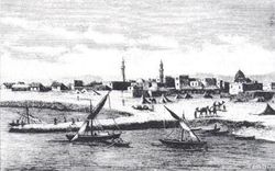
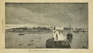
The construction of a railway from Djibouti to Addis Ababa in the late 19th century continued the neglect of Zeila.[4] At the beginning of the next century, the city was described in the 1911 Encyclopædia Britannica as having a "good sheltered anchorage much frequented by Arab sailing craft. However, heavy draught steamers are obliged to anchor a mile and a half from the shore. Small coasting boats lie off the pier and there is no difficulty in loading or discharging cargo. The water supply of the town is drawn from the wells of Takosha, about three miles distant; every morning camels, in charge of old Somali women and bearing goatskins filled with water, come into the town in picturesque procession. ... [Zeila's] imports, which reach Zaila chiefly via Aden, are mainly cotton goods, rice, jowaree, dates and silk; the exports, 90% of which are from Abyssinia, are principally coffee, skins, ivory, cattle, ghee and mother-of-pearl".[4]
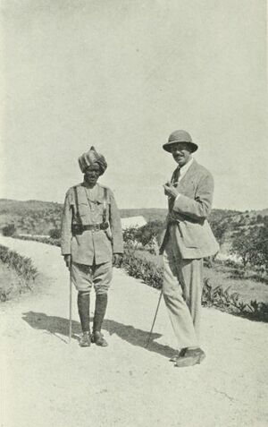
Buralle Robleh the subinspector of police of Zeila was described by Major Rayne as one of the most important men in Zeila along with 2 others. He is featured on the image to the right with General Gordon, Governor of British Somaliland.[5]
In August 1940, Zeila was captured by advancing Italian troops. It would remain under their occupation for over six months.
الحاضر
In the post-independence period, Zeila was administered as part of the official Awdal region of Somaliland.
Following the outbreak of the civil war in the early 1990s, much of the city's historic infrastructure was destroyed and many residents left the area. However, remittance funds sent by relatives abroad have contributed toward the reconstruction of the town, as well as the local trade and fishing industries.
السكان
The town of Zeila is primarily inhabited by people from the Somali ethnic group, with the Gadabuursi subclan of the Dir especially well represented.[6][7][8][9] The Issa subclan of the Dir are especially well represented in the wider Zeila District.[10]
Tim Glawion (2020) describes the clan demographics of both the town of Zeila and the wider Zeila District:
"Three distinct circles can be distinguished based on the way the security arena is composed in and around Zeila: first, Zeila town, the administrative centre, which is home to many government institutions and where the mostly ethnic Gadabuursi/Samaron inhabitants engage in trading or government service activities; second, Tokhoshi, an artisanal salt mining area eight kilometres west of Zeila, where a mixture of clan and state institutions provide security, and two large ethnic groups (Ciise and Gadabuursi/Samaron) live alongside one another; third the southern rural areas, which are almost universally inhabited by the Ciise clan, with its long, rigid culture of self-rule."[11]
Elisée Reclus (1886) describes the two main ancient routes leading from Harar to Zeila, one route passing through the country of the Gadabuursi and one route passing through Issa territory. The author describes the town of Zeila and its immediate environs as being inhabited by the Gadabuursi, whereas the wider Zeila District and countryside south of the town, as being traditional Issa clan territory:
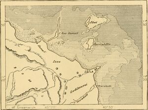
"Two routes, often blocked by the inroads of plundering hordes, lead from Harrar to Zeila. One crosses a ridge to the north of the town, thence redescending into the basin of the Awash by the Galdessa Pass and valley, and from this point running towards the sea through Issa territory, which is crossed by a chain of trachytic rocks trending southwards. The other and more direct but more rugged route ascends north-eastwards towards the Darmi Pass, crossing the country of the Gadibursis or Gudabursis. The town of Zeila lies south of a small archipelago of islets and reefs on the point of the coast where it is hemmed in by the Gadibursi tribe. It has two ports, one frequented by boats but impracticable for ships, whilst the other, not far south of the town, although very narrow, is from 26 to 33 feet deep, and affords safe shelter to large craft."[12]
المراجع
- ^ Somalia City & Town Population. Tageo.com. Retrieved 2020-03-18.
- ^ "Somalia City & Town Population" (PDF). FAO. Archived from the original (PDF) on 11 February 2015. Retrieved 20 October 2015.
- ^ Simon Imbert-Vier, Frontières et limites à Djibouti durant la période coloniale (1884–1977), Université de Provence, Aix-Marseille, 2008, p. 81.
- ^ أ ب
 Chisholm, Hugh, ed. (1911). . دائرة المعارف البريطانية. Vol. 28 (eleventh ed.). Cambridge University Press. p. 950.
 {{cite encyclopedia}}: Cite has empty unknown parameter:|coauthors=(help) - ^ Rayne, Henry A. (1921). Sun, sand, and Somals; leaves from the note-book of a district commissioner in British Somaliland. University of California Libraries. London : Witherby.
- ^ Glawion, Tim (2020-01-30). The Security Arena in Africa: Local Order-Making in the Central African Republic, Somaliland, and South Sudan (in الإنجليزية). Cambridge University Press. ISBN 978-1-108-65983-3.
Three distinct circles can be distinguished based on the way the security arena is composed in and around Zeila: first, Zeila town, the administrative centre, which is home to many government institutions and where the mostly ethnic Gadabuursi/Samaron inhabitants engage in trading or government service activities; second, Tokhoshi, an artisanal salt mining area eight kilometres west of Zeila, where a mixture of clan and state institutions provide security and two large ethnic groups (Ciise and Gadabuursi/Samaron) live alongside one another; third the southern rural areas, which are almost universally inhabited by the Ciise clan, with its long, rigid culture of self-rule.
- ^ Reclus, Elisée (1886). The Earth and its Inhabitants The Universal Geography Vol. X. North-east Africa (PDF) (in الإنجليزية). J.S. Virtue & Co, Limited, 294 City Road.
Two routes, often blocked by the inroads of plundering hordes, lead from Harrar to Zeila. One crosses a ridge to the north of the town, thence redescending into the basin of the Awash by the Galdessa Pass and valley, and from this point running towards the sea through Issa territory, which is crossed by a chain of trachytic rocks trending southwards. The other and more direct but more rugged route ascends north-eastwards towards the Darmi Pass, crossing the country of the Gadibursis or Gudabursis. The town of Zeila lies south of a small archipelago of islets and reefs on the point of the coast where it is hemmed in by the Gadibursi tribe. It has two ports, one frequented by boats but impracticable for ships, whilst the other, not far south of the town, although very narrow, is from 26 to 33 feet deep and affords safe shelter to large craft.
- ^ Samatar, Abdi I. (2001) "Somali Reconstruction and Local Initiative: Amoud University," Bildhaan: An International Journal of Somali Studies: Vol. 1, Article 9, p. 132.
- ^ Battera, Federico (2005). "Chapter 9: The Collapse of the State and the Resurgence of Customary Law in Northern Somalia". Shattering Tradition: Custom, Law and the Individual in the Muslim Mediterranean. Walter Dostal, Wolfgang Kraus (ed.). London: I.B. Taurus. p. 296. ISBN 978-1-85043-634-8. Retrieved 18 March 2010.
Awdal is mainly inhabited by the Gadabuursi confederation of clans.
- ^ Renders, Marleen; Terlinden, Ulf (13 October 2011). "Chapter 9: Negotiating Statehood in a Hybrid Political Order: The Case of Somaliland". In Tobias Hagmann; Didier Péclard (eds.). Negotiating Statehood: Dynamics of Power and Domination in Africa. p. 191. ISBN 9781444395563. Retrieved 21 January 2012.
- ^ Glawion, Tim (2020-01-30). The Security Arena in Africa: Local Order-Making in the Central African Republic, Somaliland, and South Sudan (in الإنجليزية). Cambridge University Press. ISBN 978-1-108-65983-3.
Three distinct circles can be distinguished based on the way the security arena is composed in and around Zeila: first, Zeila town, the administrative centre, which is home to many government institutions and where the mostly ethnic Gadabuursi/Samaron inhabitants engage in trading or government service activities; second, Tokhoshi, an artisanal salt mining area eight kilometres west of Zeila, where a mixture of clan and state institutions provide security and two large ethnic groups (Ciise and Gadabuursi/Samaron) live alongside one another; third the southern rural areas, which are almost universally inhabited by the Ciise clan, with its long, rigid culture of self-rule.
- ^ Reclus, Elisée (1886). The Earth and its Inhabitants The Universal Geography Vol. X. North-east Africa (PDF) (in الإنجليزية). J.S. Virtue & Co, Limited, 294 City Road.
Two routes, often blocked by the inroads of plundering hordes, lead from Harrar to Zeila. One crosses a ridge to the north of the town, thence redescending into the basin of the Awash by the Galdessa Pass and valley, and from this point running towards the sea through Issa territory, which is crossed by a chain of trachytic rocks trending southwards. The other and more direct but more rugged route ascends north-eastwards towards the Darmi Pass, crossing the country of the Gadibursis or Gudabursis. The town of Zeila lies south of a small archipelago of islets and reefs on a point of the coast where it is hemmed in by the Gadibursi tribe. It has two ports, one frequented by boats but impracticable for ships, whilst the other, not far south of the town, although very narrow, is from 26 to 33 feet deep, and affords safe shelter to large craft.
المصادر
- McClanahan, T. R.; Sheppard, C. R. C.; Obura, D. O. (2000). Coral Reefs of the Indian Ocean: Their Ecology and Conservation. Oxford University Press. ISBN 0-195-35217-3.
انظر ايضا
وصلات خارجية
المصادر
- Pages using gadget WikiMiniAtlas
- مقالات المعرفة المحتوية على معلومات من دائرة المعارف البريطانية طبعة 1911
- Short description is different from Wikidata
- Articles containing صومالية-language text
- Articles containing explicitly cited عربية-language text
- Coordinates on Wikidata
- مدن الصومال
- أرض الصومال
- تاريخ إثيوپيا
- تاريخ الصومال
- ممالك الطراز
- مدن وقرى الصومال
