دلمارڤا (شبه جزيرة)
38°30′N 75°40′W / 38.500°N 75.667°W

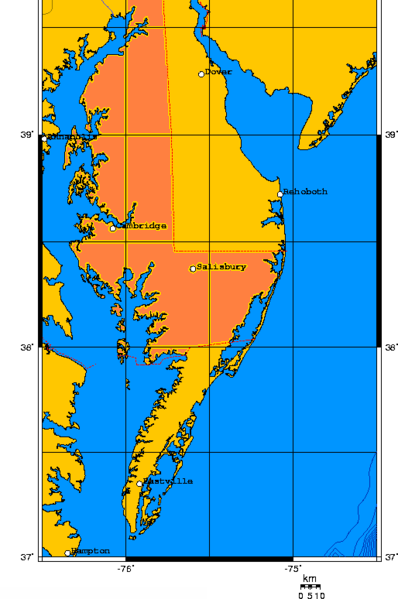
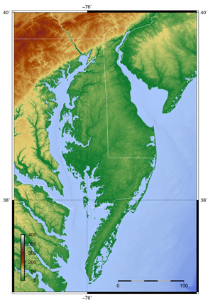
شبه جزيرة دلمارڤا Delmarva Peninsula، أو ببساطة دلمارڤا، هي شبه جزيرة كبيرة على الساحل الشرقي للولايات المتحدة، يحتلها معظم ولاية دلاوير وأجزاء من مناطق الساحل الشرقي لكل من مريلاند وڤرجينيا. يبلغ طول شبه الجزيرة 170 ميل (274 km). ويتراوح عرضها بين 70 ميل (113 km) بالقرب من وسطها، إلى 12 ميل (19 km) عند البرزخ في طرفها الشمالي، إلى عرض أضيق بالقرب من الطرف الجنوبي لـCape Charles. ويحدها خليج تشساپيك من الغرب، ونهر دلاوير، خليج دلاوير، والمحيط الأطلسي من الشرق.
أصل الاسم
في المصادر الأقدم، شبه الجزيرة بين خليج دلاوير وخليج تشساپيك كان يشار إليه بإسم شبه جزيرة دلاوير وتشساپيك أو ببساطة شبه جزيرة تشساپيك.
The toponym Delmarva is a clipped compound of Delaware, Maryland, and Virginia (official abbreviation VA), which in turn was modeled after Delmar, a border town named after two of those states. While Delmar was founded and named in 1859, the earliest uses of the name Delmarva occurred several decades later (for example on February 10, 1877 in the Middletown Transcript newspaper in Middletown, Delaware[1]) and appear to have been commercial; for example, the Delmarva Heat, Light, and Refrigerating Corp. of Chincoteague, Virginia, was in existence by 1913[2]—but general use of the term did not occur until the 1920s.[3]
الجغرافيا
At the northern point of the peninsula there is a geographic fall line that separates the crystalline rocks of the Piedmont from the unconsolidated sediments of the Coastal Plain. This line passes through Newark, Delaware and Wilmington, Delaware and Elkton, Maryland. The northern isthmus of the peninsula is transected by the sea-level Chesapeake and Delaware Canal. Several bridges cross the canal, and the Chesapeake Bay Bridge and the Chesapeake Bay Bridge–Tunnel join the peninsula to mainland Maryland and Virginia, respectively. Another point of access is Lewes, Delaware, reachable by the Cape May–Lewes Ferry from Cape May, New Jersey.
Dover, Delaware is the peninsula's largest city by population. The main commercial areas are Dover in the north and Salisbury, Maryland near its center. Including all offshore islands (the largest of which is Kent Island in Maryland), the total land area south of the Chesapeake and Delaware Canal is 5،454 sq mi (14،130 km2). At the 2000 census the total population was 681,030, giving an average population density of 124.86 inhabitants per square mile (48.21/km2).
Cape Charles forms the southern tip of the peninsula in Virginia.
The entire Delmarva Peninsula falls within the Atlantic Coastal Plain, a flat and sandy area with very few or no hills; the highest point in the peninsula is only 102 ft (31 m) above sea level.[4] The fall line, found in the region southwest of Wilmington, Delaware, and just north of the northern edge of the Delmarva Peninsula, is a geographic borderland where the Piedmont region transitions into the coastal plain. Its Atlantic Ocean coast is formed by the Virginia Barrier Islands in the south and the Fenwick Island barrier spit in the north.
التقسيمات السياسية
The border between Maryland and Delaware, which resulted from the 80-year-long Penn–Calvert Boundary Dispute, consists of the east–west Transpeninsular Line and the perpendicular north–south portion of the Mason–Dixon line extending north to just beyond its tangental intersection with the Twelve-Mile Circle which forms Delaware's border with Pennsylvania. The border between Maryland and Virginia on the peninsula follows the Pocomoke River from the Chesapeake to a series of straight surveyed lines connecting the Pocomoke to the Atlantic Ocean.
All three counties in Delaware—New Castle (partially), Kent, and Sussex—are located on the peninsula. Of the 23 counties in Maryland, nine are on the Eastern Shore: Kent, Queen Anne's, Talbot, Caroline, Dorchester, Wicomico, Somerset, and Worcester, as well as a portion of Cecil County. Two Virginia counties are on the peninsula: Accomack and Northampton.
The following is a list of some of the notable cities and towns on the peninsula.
- Cambridge, Maryland, is the county seat of Dorchester County and a busy port on the Choptank River.
- Centreville, Maryland, is the county seat of Queen Anne's County.
- Chestertown, Maryland, is the county seat of Kent County and the home of Washington College.
- Chincoteague, Virginia, is noted for its wild ponies and its beaches, administered by the U.S. Fish & Wildlife Service through Chincoteague National Wildlife Refuge.
- Crisfield, Maryland, is a notable source of seafood.
- Delmar, Maryland, part of the Salisbury Urbanized Area, lies across the Maryland-Delaware border from its twin, Delmar, Delaware, on the Transpeninsular Line.
- Dover, Delaware, is the Delaware state capital and the peninsula's largest city in terms of population.
- Easton, Maryland, is the county seat of Talbot County.
- Georgetown, Delaware, is the county seat of Sussex County. Return Day, a biennial tradition dating back to the Colonial era, is held in Georgetown two days after Election Day.[5]
- Lewes, Delaware, is the site of the first European colonization in Delaware, is nicknamed "the first town in the first state", and is a port city for the Cape May–Lewes Ferry.
- Ocean City, Maryland, is a popular beach and resort town.
- Princess Anne, Maryland, is the county seat of Somerset County and the home of the University of Maryland Eastern Shore.
- Rehoboth Beach, Delaware, "the Nation's Summer Capital", has a sixteenfold increase in population from winter to summer.
- St. Michaels, Maryland, is a popular tourist destination.
- Salisbury, Maryland, is the county seat of Wicomico County, the second largest city in the peninsula and the lower peninsula's only urbanized area. It is known as the "Crossroads of Delmarva". It is home to the Salisbury–Ocean City–Wicomico Regional Airport, the only airport on the peninsula with scheduled commercial flights. The city is also home to Salisbury University, a Maryland state university.
- Seaford, Delaware, the "Nylon Capital of the World", is the largest city in Sussex County.
At its southern tip, the Delmarva Peninsula is now connected to Virginia Beach and Hampton Roads, Virginia, via the Chesapeake Bay Bridge-Tunnel which opened in 1964. The bridge tunnel is owned and administered by the Chesapeake Bay Bridge and Tunnel District. The Chesapeake Bay Bridge-Tunnel currently has a $14.00 (US) toll for single private vehicles ($5.00 for return within 24 hours) and is patrolled by the Chesapeake Bay Bridge Tunnel Police Department.
أكبر البلديات
عواصم الولايات ومقار المقاطعات ![]()
| الترتيب | الاسم | النوع | التعداد | Area | المقاطعة | الولاية | استوطنت | أشهرت | أصل الاسم |
|---|---|---|---|---|---|---|---|---|---|
| 1 | Dover ‡ | Capital city | 38,079 | 23.48 sq mi | Kent | Delaware | 1683 | 1829 | Dover in Kent, England |
| 2 | Salisbury† | City | 32,809 | 13.40 sq mi | Wicomico | Maryland | 1732 | 1854 | |
| 3 | Middletown | Town | 22,582 | 11.83 sq mi | New Castle | Delaware | 1861 | Halfway between Bunker Hill, Maryland and Odessa, Delaware | |
| 4 | Easton† | Town | 16,494 | 10.56 sq mi | Talbot | Maryland | 1790 | ||
| 5 | Cambridge† | Town | 12,285 | 10.34 sq mi | Dorchester | Maryland | 1793 | ||
| 6 | Smyrna | Town | 11,580 | 6.01 sq mi | Kent/New Castle | Delaware | مدينة سميرنا اليونانية القديمة | ||
| 7 | Milford | City | 11,353 | 9.87 sq mi | Kent/Sussex | Delaware | Named for numerous mills around town | ||
| 8 | Seaford | City | 7,861 | 5.30 sq mi | Sussex | Delaware | 1865 | Seaford, East Sussex | |
| 9 | Georgetown † | Town | 7,427 | 5.14 sq mi | Sussex | Delaware | 1791 | 1869 | Commissioner George Mitchell |
| 10 | Ocean City | Town | 6,927 | 4.41 sq mi | Worcester | Maryland | 1875 | 1880 |
ولاية مقترحة
At various times in history, residents of the Delmarva Peninsula have proposed that its Maryland and Virginia portions secede from their respective states, merging with Kent County and Sussex County, Delaware, to create the state of Delmarva. A Delmarva State Party with this aim was founded in 1992. Its combined population would be about 750,000, or 977,511 in 2015, or 1,534,290 if New Castle County, Delaware is also included, roughly the population of Idaho, or West Virginia.[6]
الاقتصاد
The peninsula was the premier location for truck farming of vegetables during the 19th and early 20th centuries. Though it has been largely eclipsed by California's production, the area still produces significant quantities of tomatoes, green beans, corn, soybeans—Queen Anne's County is the largest producer of soy beans in Maryland—and other popular vegetables.
The Eastern Shore is also known for its poultry farms, the most well-known of which is Perdue Farms, founded in Salisbury. The Delaware is a rare breed of chicken created on the peninsula.
Tourism is a major contributor to the peninsula's economy with the beaches at Rehoboth Beach, Delaware, Ocean City, Maryland, and Assateague Island National Seashore, Virginia, being popular tourist destinations.
Salisbury University also adds to the economic activity of the Delmarva, with an estimated $480 million in contribution impact. The University is the largest four year comprehensive on the Eastern Shore, and serves as the largest employer other than Perdue supporting an estimated 3200 jobs.[7]
انظر أيضاً
- Delmarva Shorebirds
- List of railroad lines in the Delmarva Peninsula
- List of U.S. multistate regions
- Wallops Flight Facility
الهامش
- ^ Middleton Transcript February 10, 1877
- ^ Annual Report of the Secretary of the Commonwealth to the Governor and General Assembly of Virginia for the Year Ending September 30, 1914 (Richmond, Va., 1915), p. 267.
- ^ See, e.g., Michael F. Mulrooney, The Delmarva Peninsula (Wilmington, Del.?: Hearn Oil Co., 1926): the earliest use of the name in a title, per WorldCat.
- ^ "Stillpond Neck". Peakbagger. Retrieved February 19, 2014.
- ^ returnday.com
- ^ Gosier, Chris (February 20, 1998). "Would-be Secessionists Dream Up the State of Delmarva". Capital News Service. Archived from the original on March 10, 2014.
- ^ Rush, Don. "Salisbury University: $480 Million Economic Impact". www.delmarvapublicradio.net (in الإنجليزية). Retrieved 2020-10-10.
وصلات خارجية
- The Delmarva Peninsula
- "Assateague History". History of the Assategue People. Archived from the original on March 7, 2005. Retrieved March 3, 2005.
- "Maryland Charter". The Charter of Maryland at the Avalon Project. Archived from the original on March 5, 2005. Retrieved March 3, 2005.
- "Virginia Charter". The Charter of Virginia at the Avalon Project. Archived from the original on March 1, 2005. Retrieved March 3, 2005.
- Delmarva Peninsula census tracts United States Census Bureau
- The Confederation of Sovereign Nanticoke-Lenape Tribes
- Piscataway Conoy Tribe
- Pages using gadget WikiMiniAtlas
- Short description is different from Wikidata
- Coordinates on Wikidata
- مصطلحات جغرافية حديثة
- جغرافيا مقاطعة كنت، دلاوير
- تضاريس مقاطعة نيوكاسل، دلاوير
- تضاريس مقاطعة سسكس، دلاوير
- أشباه جزر دلاوير
- أشباه جزر مريلاند
- أشباه جزر ڤرجينيا
- Pre-Clovis archaeological sites in the Americas
- مناطق الولايات المتحدة
- 1850s neologisms


