نهر الدنيپر

الدنيپر ( Dnieper ؛ /(də)ˈniːpər/), also called Dnipro (/dəˈniːproʊ/) or Dniapro,[أ] أحد أطول الأنهار في أوروبا، ويجري خلال منطقة ذات أهمية. وينبع نهر الدنيبر من تلال ڤالداي بالقرب من مدينة سمولنسك في روسيا. ويجري النهر لمسافة 2,200 كم خلال كل من روسيا وروسيا البيضاء وأوكرانيا، حتى يصب في البحر الأسود. وتقع مدينة كييف، عاصمة أوكرانيا على هذا النهر. ويجري الجزء الشمالي منه في منطقة غابات، بينما يجري الجزء الجنوبي، خلال أراض زراعية ومناطق صناعية، ويغطي مساحة قدرها 504,000 كم².
وقد عمَّق بناء السدود والحواجز مجرى نهر الدنيبر وأزال منه العوائق التي سببتها المنحدرات المائية، ولهذا فإن النهر صالح للملاحة في معظم مجراه. ويُعتبر سد دنيبروجز المقام على نهر الدنيبر، واحداً من أكبر السدود المائية.
 تكسر ثلج النهر في الربيع. |
ويُعد نهر الدنيبر طريقا مهماً لنقل البضائع بما فيها الفحم الحجري والحبوب من أوكرانيا والأخشاب من المناطق الشمالية. ومن الروافد المهمة لنهر الدنيبر نهر بريزينا ونهر الديسنا، ونهر إنهوليتس، ونهر بريبات، ونهر بسيل. ويربط نظام من القنوات بين نهر الدنيبر والعديد من الأنهار التي تصب في بحر البلطيق.
الأسماء
الدنيبر
 Human representation of the Dnieper river (known as Borysthenes) على عملة يونانية قديمة من Pontic Olbia, القرنان 4th–3rd ق.م. |
.jpg&filetimestamp=20240325054248&)
In English, the name Dnieper is attested by the early 17th century, along with obsolete forms Deneper, Neper.[2] The river is also sometimes called by the Russian name Dnepr.[3][4] The initial D in Dnieper is generally silent when pronounced in English, although it may be sounded: /ˈniːpər/[5] or /dəˈniːpər/.[6] It derives from روسية: Днепр, romanized: Dnepr[7]قالب:BSN (pre-revolutionary spelling Днѣпръ, Dněpr).
Dnipro derives from أوكرانية: Дніпро, romanized: Dnipro.[7] The English pronunciation is /dəˈniːproʊ/.[8] The Ukrainian name has a rare form Дніпр, Dnipr and rare dialectal Дніпер, Dniper.[9] The Middle Ukrainian form attested in the sixteenth to eighteenth centuries was Днѣпръ, Dnǐpr.[9] The city of Dnipro is named for the river.
The name varies slightly in the local Slavic languages of the three countries through which it flows:
- بالبيلاروسية: Дняпро, [dⁿʲaˈprɔ], or Днепр Dnyepr,[10] [ˈdⁿʲɛpr]
- روسية: Днепр, النطق Dnepr; النطق الروسي: [ˈdⁿʲepr]; formerly spelled Днѣпръ[11]
- أوكرانية: Дніпро, romanized: Dnipro, IPA: [ɟⁿʲiˈprɔ](
 استمع); poetic Дніпр, Dnipr; formerly Дніпер[12] Dniper, [ˈɟⁿʲiper], or older Днѣпръ[citation needed] (Dnipr, [ˈdⁿ⁽ʲ⁾ipr][citation needed])
These names are all cognate, deriving from Old East Slavic Дънѣпръ (Dŭněprŭ). The origin of this name is disputed but generally derived from either Sarmatian *Dānu Apara ("Farther River") in parallel with the Dniester ("Nearer River") or from Scythian *Dānu Apr ("Deep River") in reference to its lack of fords,[13][14] from which was also derived the Late Antique name of the river, Danapris (Δαναπρις).[15]
بوريستينس
The earlier Graeco-Roman name of the river was Borysthenes (باليونانية قديمة: Βορυσθενης; لاتينية: Borysthenes, أوكرانية: Бористен, Борисфен, romanized: Borysten, Borysfen[9]), which was derived from a Scythian name whose form was:
- either Baurastāna, meaning "yellow place,"[16]
- or Baurustāna meant "place of beavers."[17]
- this name was linked to the mantle of beaver skins worn by the Iranic water goddess Arəduuī Sūrā Anāhitā, whose epithet of āp (آڤستان: 𐬁𐬞, lit. 'water') was connected to the name of the daughter of the river-god Borysthenēs in Scythian mythology, the Earth-and-Water goddess Api, whose own name meant "water."[17]
Ovid used Borysthenius, an adjective derived from Borysthenes, as the river's poetic Latin name.[18]
ڤار
The Huns' name for the river, Var, was derived from Scythian *Varu, meaning "Broad." This name was connected to the Graeco-Roman name of the Volga river, Oarus (باليونانية قديمة: Οαρος; لاتينية: Oarus), which was also derived from Scythian *Varu.[19]
أسماء أخرى
In Ukrainian it is also known poetically as Славутич, Slavutych or Славута, Slavuta,[9] from an old name used in Kievan Rus'. This is due to the influence of the Old East Slavic epic The Tale of Igor's Campaign and its modern adaptations on Ukrainian literature. This usage also lent its name to the city of Slavutych, founded in the wake of the Chernobyl disaster in 1986 to house displaced workers,[20][صفحة مطلوبة] and to the Slavutych station of the Kyiv Metro.
In Crimean Tatar, the river is known as Özü. In Romanian, it is Nipru. In Turkish it is Dinyeper, Özü, or Özi.[21]
The Kipchak Turks called it the Uzeu[citation needed]. During the period of Old Great Bulgaria, it was known as Buri-Chai[citation needed]
الجغرافيا
الطول الإجمالي للنهر يتراوح بين 2,145 كم[22] و 2,201 كم،[23][24][25][26] منها 485 كم داخل روسيا، 700 كم داخل بلاروس،[22] و 1095 كم هم داخل أوكرانيا. حوضه يغطي 504,000 كم²، منها 289,000 كم² داخل أوكرانيا،[27] 118,360 كم داخل بلاروس.[22]
منبع الدنيبر هو the sedge bogs (Akseninsky Mokh) في Valdai Hills في وسط روسيا على ارتفاع 220 كم.[27] For 115 كم من طوله، it serves as the border between Belarus and Ukraine. Its estuary, or liman, used to be defended by the strong fortress of Ochakiv.[citation needed][28]
أقصى النقاط جنوباً في بلاروس هي على الدنيبر إلى الجنوب من كامارين في رايون براهين.[29]
الروافد

للدنيبر العديد من الروافد (تصل إلى 32,000) منهم 89 هم أنهار بطول 100+ كم.[30] الرئيسيون هم، من المنبع إلى المصب، مع تبيان الضفة اليسرى (L) أو اليمنى (R):

- ڤيازما (L)
- ڤوپ (R)
- خموست (R)
- مياريا (L)
- دروت (R)
- Berezina (R)
- Sozh (L)
- Pripyat (R)
- تتريڤ (R)
- Irpin (R)
- Desna (L)
- ستوهنا (R)
- Trubizh (L)
- روس (R)
- Tiasmyn (R)
- Supii (L)
- سولا (L)
- Psel (L)
- Vorskla (L)
- Oril (L)
- Samara (L)
- Konka (Kherson Oblast)
- Konka (Zaporizhzhia Oblast)
- Bilozerka (L)
- Bazavluk (R)
- إنهولتس (R)
كما يوجد العديد من الروافد المباشرة الصغيرة، كما في منطقة كييڤ، السيريتس (الضفة اليمنى) في شَمال المدينة، ليبيد البارز تاريخياً (الضفة اليمنى) المار غرب المركز، و Borshahivka (الضفة اليمنى) إلى الجنوب.
مصادر المياه لحوض الدنيبر تشكل نحو 80% من إجمالي مصادر المياه في أوكرانيا.[30]
المَسارِع

.jpg&filetimestamp=20240325054346&)
The Dnieper Rapids were part of the trade route from the Varangians to the Greeks, first mentioned in the Kyiv Chronicle.[مطلوب توضيح] The route was probably established in the late eighth and early ninth centuries and gained significant importance from the tenth until the first third of the eleventh century. On the Dnieper the Varangians كان عليهم حمل سفنهم على أكتافهم حول سبع مَسارِع، حيث كانوا يضعون الحرس ترقباً للرحل من الپچنگ.
Along this middle flow of the Dnieper, there were 9 major rapids (although some sources cite a smaller number), obstructing almost the whole width of the river, about 30 to 40 smaller rapids, obstructing only part of the river, and about 60 islands and islets.
After the Dnieper hydroelectric station was built in 1932, they were inundated by Dnieper Reservoir.
القنوات
There are a number of canals connected to the Dnieper:
- The Dnieper–Donbas Canal;
- The Dnieper–Kryvyi Rih Canal;
- The Kakhovka Canal (southeast of the Kherson region);
- The Krasnoznamianka Irrigation System in the southwest of the Kherson region;
- The North Crimean Canal—will largely solve the water problem of the peninsula, especially in the arid northern and eastern Crimea;
- The Inhulets Irrigation System.
الوحيش
The river is part of the quagga mussel's native range.[31] The mussel has been accidentally introduced around the world, where it has become an invasive species.[31]
الدلتا

The city of Kherson lies on the northern bank, upstream of the Dnieper delta, before the Dnieper meets the Southern Bug river in the Dniprovska Gulf.
البيئة
Nowadays the Dnieper River suffers from anthropogenic influence resulting in numerous emissions of pollutants.[32] The Dnieper is close to the Prydniprovsky Chemical Plant radioactive dumps (near Kamianske) and susceptible to leakage of its radioactive waste. The river is also close to the Chernobyl Nuclear Power Station (Chernobyl Exclusion Zone) which is located next to the mouth of the Pripyat River.
الملاحة
Almost 2،000 km (1،200 mi) of the river is navigable (to the city of Dorogobuzh).[30] The Dnieper is important for transportation in the economy of Ukraine.[citation needed] Its reservoirs have large ship locks, allowing vessels of up to 270 في 18 متر (886 ft × 59 ft) access as far as the port of Kyiv, and thus are an important transportation corridor.[citation needed] The river is used by passenger vessels as well. Inland cruises on the rivers Danube and Dnieper have had a growing market in recent decades.[citation needed]
Upstream from Kyiv, the Dnieper receives the water of the Pripyat River. This navigable river connects to the Dnieper-Bug canal, the link with the Bug River. Historically, a connection with the Western European waterways was possible, but a weir without any ship lock near the town of Brest, Belarus, has interrupted this international waterway. Poor political relations between Western Europe and Belarus mean there is little likelihood of reopening this waterway in the near future.[33] River navigation is interrupted each year by freezing and severe winter storms.
الخزانات ومحطات الطاقة الكهرومائية

From the mouth of the Pripyat River to the Kakhovka Hydroelectric Station, there are six sets of dams and hydroelectric stations, which produce 10% of Ukraine's electricity.[30] The Kakhovka dam was destroyed on 6 June 2023 during the Russian invasion of Ukraine,[34] with the subsequent drying up of the Kakhovka Reservoir revealing the original course of the river in the area and disconnecting four canal networks.[35]
The first constructed was the Dnieper Hydroelectric Station (or DniproHES) near Zaporizhzhia, built between 1927 and 1932 with an output of 558 MW.[36] It was destroyed during World War II, but was rebuilt in 1948 with an output of 750 MW.[citation needed]
| الموقع | السد | مساحة الخزان | محطة الطاقة الكهرومائية | تاريخ الإنشاء |
|---|---|---|---|---|
| كييڤ | خزان كييڤ | 922 km2 أو 356 sq mi | Kyiv Hydroelectric Station | 1960–1964 |
| كانيڤ | خزان كانيڤ | 675 km2 أو 261 sq mi | Kaniv Hydroelectric Station | 1963–1975 |
| كريمنتشوك | Kremenchuk Reservoir | 2،250 km2 أو 870 sq mi | Kremenchuk Hydroelectric Station | 1954–1960 |
| كاميانسكى | Kamianske Reservoir | 567 km2 أو 219 sq mi | Middle Dnieper Hydroelectric Power Plant | 1956–1964 |
| زاپوريجيا | خزان الدنيبر | 420 km2 أو 160 sq mi | Dnieper Hydroelectric Station | 1927–1932; 1948 |
| كاخوڤكا | خزان كاخوڤكا | 2،155 km2 أو 832 sq mi | Kakhovka Hydroelectric Station† | 1950–1956 |
المناطق والمدن

المناطق
|
|
|
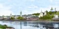
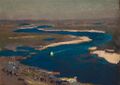
- The Dnieper River in different regions
The Dnieper River in Dorogobuzh, Russian Empire, before 1917

The Dnieper River in Kremenchuk, Ukraine
The Dnieper river in Ukraine from a helicopter, 2004

المدن
Cities and towns located on the Dnieper are listed in order from the river's source (in Russia) to its mouth (in Ukraine):
|
Arheimar, a capital of the Goths, was located on the Dnieper, according to the Hervarar saga.[37]
في الفنون
الأدب
The River Dnieper has been a subject of chapter X of a story by Nikolai Gogol A Terrible Vengeance (1831, published in 1832 as a part of the Evenings on a Farm Near Dikanka short stories collection). It is considered as a classical example of description of the nature in Russian literature. The river was also described in the works of Taras Shevchenko.
In the adventure novel The Long Ships (also translated Red Orm), set during the Viking Age, a Scanian chieftain travels to the Dnieper Rapids to retrieve a treasure hidden there by his brother, encountering many difficulties. The novel was very popular in Sweden and is one of few to depict a Viking voyage to eastern Europe.
الفنون البصرية
The River Dnieper has been a subject for artists, great and minor, over the centuries. Major artists with works based on the Dnieper are Arkhip Kuindzhi and Ivan Aivazovsky.
الأفلام
The River Dnieper makes an appearance in the 1964 Hungarian drama film The Sons of the Stone-Hearted Man (based on the novel of the same name by Mór Jókai), where it appears when two characters are leaving Saint Petersburg but get attacked by wolves.
In 1983, the concert program "Song of the Dnieper" from the "Victory Salute" series was released, dedicated to the 40th anniversary of the liberation of the city of Kiev from the German fascist invaders. The program includes songs by Soviet composers, Ukrainian folk songs, and dances performed by the Song and Dance Ensemble of the Kiev Military District led by A. Pustovalov, P. Virsky Ukrainian National Folk Dance Ensemble, Kyiv Bandurist Capella, the Military Band of the Headquarters of the Kiev Military District led by A. Kuzmenko, singers Anatoliy Mokrenko, Lyudmila Zykina, Anatoliy Solovianenko, Dmytro Hnatyuk, Mykola Hnatyuk. Filming on the battlefield, streets and squares of Kiev. Scriptwriter – Victor Meerovsky. Directed by Victor Cherkasov. Operator – Alexander Platonov.[38]
The 2018 film Volcano was filmed at the river in Beryslav, Kherson Oblast.
الموسيقى
In 1941, Mark Fradkin wrote "Song of the Dnieper" to the words of Yevgeniy Dolmatovsky.[39]
معرض صور
- The Dnieper in painting
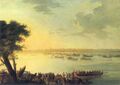
Catherine II leaving Kaniów in 1787 by Johann Gottlieb Plersch

Dnieper by Arkhip Kuindzhi, 1881

Ice in the Dnieper by Ivan Aivazovsky, 1872
Sapphire Dnieper by Jan Stanisławski, 1904


.jpg&filetimestamp=20240325054248)
.jpg&filetimestamp=20240325054346)
الثقافة الشعبية
- The river is one of the symbols of the Ukrainian nation[40] and is mentioned in the national anthem of Ukraine.
- There are several historical names that connect the name of the river with Ukraine: Dnieper Ukraine (Naddniprianshchyna), Right-bank Ukraine, Left-bank Ukraine, and others.
- The cities Dnipro, Dniprorudne, Kamianka-Dniprovska are named after the river.
- The Zaporozhian Cossacks lived on the lower Dnieper and their name refers to their location "beyond the rapids".[41]
- The folk metal band Turisas have a song called "The Dnieper Rapids" on their 2007 album The Varangian Way.[42]
انظر أيضا
- 2022–23 Dnipro River skirmishes
- List of crossings of the Dnieper
- List of rivers of Belarus
- قائمة أنهار روسيا
- قائمة أنهار أوكرانيا
- Middle Dnieper culture
- طريق التجارة من الڤرنگ إلى اليونانيين
المصادر والهوامش
ملاحظات
- ^ بالبيلاروسية: Дняпро;
روسية: Днепр, romanized: Dnepr، تـُنطق [dⁿʲepr];
أوكرانية: Дніпро, romanized: Dnipro, تـُنطق [dⁿ⁽ʲ⁾iˈprɔ]( استمع).
المراجع
- ^ "Dnieper River Floodplain". Ramsar Sites Information Service. Retrieved 25 April 2018.
- ^ D'Avity, Pierre (1615). The Estates, Empires, and Principalities of the World (in الإنجليزية). Translated by Grimeston, Edward. London. p. 689.
Boryſthenes, called vulgarly Dnieper, Deneper, or Neper
- ^ "Dnepr". Collins English Dictionary. HarperCollins. Retrieved 2023-12-03.
- ^ "Dnepr". Dictionary.com (Random House Unabridged Dictionary). Retrieved 2023-12-03.
- ^ قالب:Cite Merriam-Webster
- ^ "Dnieper". Lexico UK English Dictionary. Oxford University Press. Archived from the original on 2020-12-02.
- ^ أ ب Cybriwsky, Roman A. (2018). Along Ukraine's river : a social andenvironmental history of the Dnipro (in الإنجليزية). Budapest: Central European University Press. p. 7. ISBN 978-963-386-205-6. OCLC 1038735219.
Much of the world knows the Dnipro only as the Dnieper, a name based on the Russian-language Dnepr and widely used before Ukraine achieved its independence in 1991, in concert with the fall of the Soviet Union. "Dnipro" is the Ukrainian-language word for the river, and is now its official name for international usage.
- ^ Dnipro www.dictionary.com
- ^ أ ب ت ث Runyc'kyj, Jaroslav B. (1982). An Etymological Dictionary of the Ukrainian Language (in الإنجليزية). Vol. II. Ottawa: Ukrainian Mohylo-Mazepian Academy of Sciences and Ukrainian Language Association. pp. 154–56.
- ^ Блакітная кніга Беларусі: Энцыклапедыя. — Мінск: Беларуская Энцыклапедыя, 1994. — С. 144. — 415 с. — 10 000 экз.
- ^ Турбин, Сергей Иванович (1879). "Днѣпр и приднѣпровье: Описаніе губерній, смоленкой, Минской. Черниговской, Киевской, Полтавской, Екатеринославской, Херсонской, Таврической и Курской".
- ^ "Тлумачення / значення слова "ДНІПЕР" | Словник української мови. Словник Грінченка" [Interpretation / meaning of the word "DNIPER" | Dictionary of the Ukrainian language. Grinchenko's dictionary]. hrinchenko.com.
- ^ Mallory, J. P.; Mair, Victor H. (2000). The Tarim Mummies: Ancient China and the Mystery of the Earliest Peoples from the West. London: Thames and Hudson. p. 106. ISBN 0-500-05101-1.
- ^ Абаев В. И. Осетинский язык и фольклор (tr "Ossetian language and folklore"). Moscow: Publishing house of Soviet Academy of Sciences, 1949. p. 236
- ^ Smith, Philip (1854). "BORY´STHENES". In Smith, William (ed.). Dictionary of Greek and Roman Biography and Mythology. London: John Murray.
- ^ Bukharin 2013, p. 23.
- ^ أ ب Kullanda 2013, p. 39-41.
- ^ Lewis, Charlton; Short, Charles (1879). "Bŏrysthĕnes, is". A Latin Dictionary. Founded on Andrews' edition of Freund's Latin dictionary. revised, enlarged, and in great part rewritten by. Charlton T. Lewis, Ph.D. and. Charles Short, LL.D. Oxford: Clarendon Press.
- ^ Harmatta 1999, p. 129.
- ^ Яцик, А. В.; Яковлєв, Є. О.; Осадчук, В. О. (2002). А. В. Яцика (ed.). До питання щодо спуску Київського водосховища (Do pytanni︠a︡ shchodo spusku kyïvsʹkoho vodoskhovyshcha) (in الأوكرانية). Kiev: Оріяни (Oriany). pp. 6–12. ISBN 966-7373-78-9.
- ^ Temel Öztürk (1988–2016). "ÖZÜ: Günümüzde Ukrayna sınırları içinde bulunan tarihî bir kale ve şehir.". TDV Encyclopedia of Islam (44+2 vols.) (in Turkish). Istanbul: Turkiye Diyanet Foundation, Centre for Islamic Studies.
{{cite encyclopedia}}: CS1 maint: unrecognized language (link) - ^ أ ب ت خطأ استشهاد: وسم
<ref>غير صحيح؛ لا نص تم توفيره للمراجع المسماةstatistics - ^ Zastavnyi, F. D. (2000). Physical Geography of Ukraine. Rivers of Ukraine. Dnieper. Forum. Kyiv.
{{cite book}}: CS1 maint: location missing publisher (link) - ^ Masliak, P.; Shyshchenko, P. (1998). Heohrafii︠a︡ Ukraïny [Geography of Ukraine]. Zodiak-eko. Kyiv. ISBN 966-7090-06-X.
{{cite book}}: CS1 maint: location missing publisher (link) - ^ "Website about Dnieper". Archived from the original on 21 February 2014. Retrieved 6 February 2014.
- ^ Mishyna, Liliana. Hydrographic research of Dnieper river Archived 4 مارس 2016 at the Wayback Machine. Derzhhidrohrafiya.
- ^ أ ب Kubiyovych, Volodymyr; Ivan Teslia. "Dnieper River". Encyclopedia of Ukraine. Retrieved 19 January 2007.
- ^ Sigismund von Herberstein places 'Oczakow' (today's "Ochakiv") على ساحل البحر الأسود (Ponti Evxini) في خريطته من عام 1549.www.baarnhielm.net Archived 17 سبتمبر 2009 at the Wayback Machine
- ^ "Main Geographic Characteristics of the Republic of Belarus. Coordinates of the extreme points of the state frontier". Land of Ancestors. The Scientific and Production State Republican Unitary Enterprise "National Cadastre Agency" of the State Property Committee of the Republic of Belarus. 2011. Retrieved 20 September 2013.
- ^ أ ب ت ث Splendid Dnieper. لا يوجد نهر أكثر استقامة. Ukrinform. 4 July 2015
- ^ أ ب Benson, AJ. "Dreissena rostriformis bugensis Andrusov, 1897". Nonindigenous Aquatic Species. United States Geological Survey. Retrieved 2 May 2014.
- ^ Snytko, V.; Shirokova, V.; Ozerova, N.; Romanova, O.; Sobisevich, A. (2017). "Hydrological situation of the Upper Dnieper". GeoConference SGEM. 17 (31): 379–384.
- ^ "PC-Navigo – Dé routeplanner voor de binnenwateren" [PC-Navigo – The route planner for inland waterways]. PC Navigo. Archived from the original on 9 November 2005.
- ^ No label or title -- debug: Q119224855, Wikidata Q119224855
- ^ "Ukraine dam: Satellite images reveal Kakhovka canals drying up". BBC. 22 June 2023.
- ^ Hewett, Edward A.; Winston, Victor H. (1991). Milestones in Glasnost and Perestroyka: Politics and people. Brookings Institution. p. 19. ISBN 9780815736240.
The importance of Chernobyl' for Soviet industry is best illustrated by comparing it to the key energy project of Stalin's industrialization, the famous Dnieper hydroelectric station, completed in 1932. The largest European hydroelectric station of its time, it had a capacity of 560 MW.
- ^ "An English translation of Hervar saga by Kershaw". Archived from the original on 28 March 2006. Retrieved 28 March 2006.
- ^ Victory Salute. Song of the Dnieper (1983) at YouTube
- ^ Kyiv Bandurist Capella – Song of the Dnieper at YouTube
- ^ Work on the subject Ukrainian national symbols. Library of Ukrainian literature.
- ^ "...the Zaporohjans whose name meant 'those who live beyond the cataracts'...", Henryk Sienkiewicz, With Fire and Sword, chap. 7.
- ^ "Releases". www.turisas.com.
وصلات خارجية
- Dnieper River at the Encyclopedia of Ukraine
- 1911 Encyclopædia Britannica — Dnieper
- Brockhaus and Efron Encyclopedic Dictionary — Dnepr
- Site about Dnieper — objects over the river, photos, facts
| الروافد1 |  | |
|---|---|---|
| الخزانات | ||
| المحطات الكهرومائية | ||
| القنوات | ||
| المدن | ||
| المعابر | ||
| ||
- Pages using gadget WikiMiniAtlas
- Articles containing بلاروسية-language text
- Articles containing روسية-language text
- Pages using Lang-xx templates
- Articles containing أوكرانية-language text
- CS1 الأوكرانية-language sources (uk)
- CS1 maint: location missing publisher
- Short description is different from Wikidata
- Coordinates on Wikidata
- Pages with plain IPA
- Articles with unsourced statements from September 2022
- Articles containing Old East Slavic-language text
- Articles containing Scythian-language text
- Articles containing لاتينية-language text
- Articles containing Ancient Greek (to 1453)-language text
- Articles containing آڤستان-language text
- مقالات بالمعرفة بحاجة لذكر رقم الصفحة بالمصدر from March 2022
- Articles containing Crimean Tatar-language text
- Articles containing رومانية-language text
- Articles with unsourced statements from March 2023
- Articles with unsourced statements from March 2022
- Articles with hatnote templates targeting a nonexistent page
- Articles with unsourced statements from April 2011
- جميع الصفحات التي تحتاج تنظيف
- مقالات بالمعرفة تحتاج توضيح from April 2018
- Articles with unsourced statements from February 2010
- Articles with unsourced statements from June 2020
- نظام نهر الدنيپر
- أنهار دولية في أوربيا
- Rivers of Smolensk Oblast
- حدود أوكرانيا-بلاروس
- Homiel Voblast
- أبلاست زاپوريجيا
- كييڤ
- Poltava Oblast
- أبلاست تشركاسي
- Dnipropetrovsk Oblast
- أبلاست خرسون
- أنهار بيلاروس
- أنهار أوكرانيا