مقاطعة يونيون، نيوجرزي
Union County | |
|---|---|
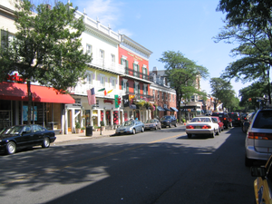 Downtown Westfield in July 2005 | |
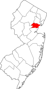 الموقع ضمن ولاية New Jersey | |
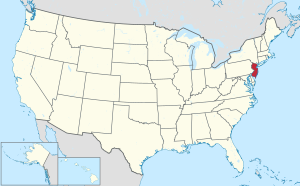 موقع New Jersey ضمن الولايات المتحدة | |
| الإحداثيات: 40°39′N 74°17′W / 40.65°N 74.29°W | |
| البلد | |
| State | |
| تأسست | 1857[1] |
| السمِيْ | Union threatened by slavery dispute[2] |
| Seat | Elizabeth[3] |
| أكبر مدينة | Elizabeth (population and area) |
| الحكومة | |
| • Freeholder chairman | Bette Jane Kowalski (D, term ends December 31, 2019)[4] |
| المساحة | |
| • الإجمالي | 105٫40 ميل² (273�0 كم²) |
| • البر | 102٫86 ميل² (266٫4 كم²) |
| • الماء | 2٫55 ميل² (6٫6 كم²) 2.42% |
| التعداد (2010) | |
| • الإجمالي | 536٬499 |
| • Estimate (2019) | 556٬341 |
| • الكثافة | 5٬100/sq mi (2٬000/km2) |
| Congressional districts | 7th، 8th، 10th، 12th |
| الموقع الإلكتروني | www |
Union County is a county in the U.S. state of New Jersey. As of the 2019 Census estimate, the county's population was 556,341, making it the seventh-most populous of the state's 21 counties,[5][6][7] an increase of 5.1% from the 2010 United States Census, when its population was enumerated at 536,499,[8] in turn an increase of 13,958 (2.7%) from the 522,541 enumerated in the 2000 Census.[9] In 2010, Union County slipped to the seventh-most populous county in the state, having been surpassed by Ocean County.[10][11] Union County is part of the New York metropolitan area. Its county seat is Elizabeth.[3]
In 2015, the county had a per capita personal income of $60,089, the seventh-highest in New Jersey and ranked 152nd of 3,113 counties in the United States.[12][13] The Bureau of Economic Analysis ranked the county as having the 119th-highest per capita income of all 3,113 counties in the United States (and the eighth-highest in New Jersey) in 2009.[14] A study by Forbes.com determined that Union County pays the second-highest property taxes of all U.S. counties, based on 2007 data.[15]
With a population density of 4,955 people per square mile (water excluded), Union County was the 15th-most densely populated county in the United States as of the 2010 Census, and third-densest in New Jersey, behind Hudson County (ranked 6th nationwide at 9,754 per square mile) and Essex County (ranked 11th at 6,126).[16][17]
المقاطعات المجاورة
Union County adjoins the following counties:[18]
- Essex County – north
- Hudson County – northeast
- Richmond County, New York – east
- Middlesex County – south
- Somerset County – west
- Morris County – northwest
السكان
| التعداد | Pop. | ملاحظة | %± |
|---|---|---|---|
| 1860 | 27٬780 | — | |
| 1870 | 41٬859 | 50٫7% | |
| 1880 | 55٬571 | 32٫8% | |
| 1890 | 72٬467 | 30٫4% | |
| 1900 | 99٬353 | 37٫1% | |
| 1910 | 140٬197 | 41٫1% | |
| 1920 | 200٬157 | 42٫8% | |
| 1930 | 305٬209 | 52٫5% | |
| 1940 | 328٬344 | 7٫6% | |
| 1950 | 398٬138 | 21٫3% | |
| 1960 | 504٬255 | 26٫7% | |
| 1970 | 543٬116 | 7٫7% | |
| 1980 | 504٬094 | −7٫2% | |
| 1990 | 493٬819 | −2�0% | |
| 2000 | 522٬541 | 5٫8% | |
| 2010 | 536٬499 | 2٫7% | |
| 2019 (تق.) | 556٬341 | [19] | 3٫7% |
| Historical sources: 1790–1990[20] 1970–2010[11] 2000[9] 2010[8] 2000–2010[21] 2010-2019 | |||
Government
السياسة
| Year | Republican | Democratic | Third parties |
|---|---|---|---|
| 2016 | 30.5% 68,114 | 65.9% 147,414 | 3.6% 8,042 |
| 2012 | 32.5% 68,314 | 66.5% 139,752 | 1.0% 2,022 |
| 2008 | 35.4% 78,768 | 63.6% 141,417 | 1.0% 2,241 |
| 2004 | 40.6% 82,517 | 58.7% 119,372 | 0.8% 1,613 |
| 2000 | 36.8% 68,554 | 60.1% 112,003 | 3.1% 5,816 |
| 1996 | 34.7% 65,912 | 56.8% 108,102 | 8.5% 16,227 |
| 1992 | 41.8% 87,742 | 46.0% 96,671 | 12.2% 25,699 |
| 1988 | 54.3% 112,967 | 44.8% 93,158 | 1.0% 2,028 |
| 1984 | 59.1% 135,446 | 40.2% 92,056 | 0.7% 1,638 |
| 1980 | 51.7% 112,288 | 39.6% 86,074 | 8.7% 18,977 |
| 1976 | 51.6% 118,019 | 46.4% 106,267 | 2.0% 4,616 |
| 1972 | 61.0% 148,290 | 37.2% 90,482 | 1.7% 4,201 |
| 1968 | 45.7% 110,309 | 45.5% 109,674 | 8.8% 21,273 |
| 1964 | 33.3% 82,999 | 66.2% 164,989 | 0.6% 1,359 |
| 1960 | 50.3% 123,224 | 49.0% 119,986 | 0.7% 1,798 |
| 1956 | 67.6% 146,228 | 31.2% 67,540 | 1.2% 2,646 |
| 1952 | 60.5% 122,885 | 38.5% 78,336 | 1.0% 2,024 |
| 1948 | 53.9% 87,402 | 41.2% 66,759 | 4.9% 8,019 |
| 1944 | 52.6% 86,543 | 46.2% 75,969 | 1.3% 2,113 |
| 1940 | 52.5% 79,962 | 46.5% 70,737 | 1.1% 1,597 |
| 1936 | 45.1% 59,553 | 53.6% 70,813 | 1.3% 1,731 |
| 1932 | 54.9% 67,512 | 41.8% 51,357 | 3.3% 4,092 |
| 1928 | 64.2% 68,119 | 35.3% 37,476 | 0.5% 497 |
| 1924 | 68.0% 50,356 | 19.9% 14,738 | 12.1% 8,966 |
| 1920 | 72.6% 39,409 | 22.3% 12,103 | 5.1% 2,791 |
| 1916 | 59.2% 16,705 | 36.6% 10,328 | 4.2% 1,181 |
| 1912 | 21.6% 5,421 | 38.5% 9,695 | 39.9% 10,040[23] |
| 1908 | 60.9% 15,920 | 33.7% 8,809 | 5.4% 1,414 |
| 1904 | 58.9% 13,906 | 36.3% 8,574 | 4.8% 1,120 |
| 1900 | 59.0% 12,533 | 36.1% 7,667 | 5.0% 1,061 |
| County CPVI: D+16 | |||
Economy
The top employers in 2011, according to the Union County Economic Development Corporation, were:[24]
| # | Employer | # of employees |
|---|---|---|
| 1 | Merck & Co. | 10,000 |
| 2 | New England Motor Freight | 3,900 |
| 3 | USI Services Group | 3,200 |
| 4 | Overlook Medical Center | 2,961 |
| 5 | Maher Terminals | 1,700 |
| 6 | Trinitas Hospital | 1,674 |
| 7 | Children's Specialized Hospital | 1,440 |
| 8 | Alcatel-Lucent | 1,300 |
| 9 | ConocoPhillips | 1,000 |
Municipalities
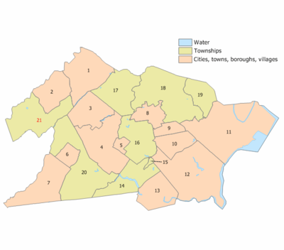
Municipalities in Union County (with 2010 Census data for population, housing units and area) are:[25]
| Municipality (with map key) |
Municipal type |
Population | Housing Units |
Total Area |
Water Area |
Land Area |
Pop. Density |
Housing Density |
Communities[26] |
|---|---|---|---|---|---|---|---|---|---|
| Berkeley Heights (21) | township | 13,183 | 4,596 | 6.27 | 0.05 | 6.21 | 2,122.4 | 739.9 | Murray Hill (part) |
| Clark (14) | township | 14,756 | 5,751 | 4.49 | 0.19 | 4.30 | 3,430.5 | 1,337.0 | |
| Cranford (16) | township | 22,625 | 8,816 | 4.87 | 0.04 | 4.83 | 4,684.6 | 1,825.4 | |
| Elizabeth (11) | city | 124,969 | 45,516 | 13.46 | 1.15 | 12.32 | 10,144.1 | 3,694.7 | |
| Fanwood (6) | borough | 7,318 | 2,686 | 1.34 | 0.00 | 1.34 | 5,454.1 | 2,001.9 | |
| Garwood (5) | borough | 4,226 | 1,870 | 0.66 | 0.00 | 0.66 | 6,362.7 | 2,815.5 | |
| Hillside (19) | township | 21,404 | 7,536 | 2.76 | 0.01 | 2.75 | 7,784.0 | 2,740.6 | |
| Kenilworth (8) | borough | 7,914 | 2,924 | 2.16 | 0.00 | 2.16 | 3,668.3 | 1,355.3 | |
| Linden (12) | city | 40,499 | 15,872 | 11.41 | 0.73 | 10.68 | 3,793.8 | 1,486.8 | |
| Mountainside (3) | borough | 6,685 | 2,558 | 4.05 | 0.04 | 4.01 | 1,668.0 | 638.3 | |
| New Providence (2) | borough | 12,171 | 4,537 | 3.66 | 0.02 | 3.64 | 3,343.4 | 1,246.3 | Murray Hill (part) |
| Plainfield (7) | city | 49,808 | 16,621 | 6.03 | 0.01 | 6.02 | 8,270.1 | 2,759.8 | |
| Rahway (13) | city | 27,346 | 11,300 | 4.03 | 0.13 | 3.90 | 7,016.8 | 2,899.5 | |
| Roselle (10) | borough | 21,085 | 7,939 | 2.66 | 0.01 | 2.65 | 7,953.5 | 2,994.7 | |
| Roselle Park (9) | borough | 13,297 | 5,231 | 1.23 | 0.00 | 1.23 | 10,792.7 | 4,245.8 | |
| Scotch Plains (20) | township | 23,510 | 8,896 | 9.05 | 0.03 | 9.02 | 2,606.9 | 986.4 | |
| Springfield (17) | township | 15,817 | 6,736 | 5.19 | 0.02 | 5.17 | 3,057.2 | 1,302.0 | |
| Summit (1) | city | 21,457 | 8,190 | 6.05 | 0.05 | 6.00 | 3,578.9 | 1,366.0 | |
| Union (18) | township | 56,642 | 20,250 | 9.09 | 0.02 | 9.07 | 6,244.3 | 2,232.4 | |
| Westfield (4) | town | 30,316 | 10,950 | 6.74 | 0.02 | 6.72 | 4,512.2 | 1,629.8 | |
| Winfield (15) | township | 1,471 | 714 | 0.18 | 0.00 | 0.18 | 8,320.1 | 4,038.5 | |
| Union County | county | 536,499 | 199,489 | 105.40 | 2.55 | 102.85 | 5,216.1 | 1,939.5 |
انظر أيضاً
الهامش
- ^ خطأ استشهاد: وسم
<ref>غير صحيح؛ لا نص تم توفيره للمراجع المسماةStory - ^ Hutchinson, Viola L. The Origin of New Jersey Place Names, New Jersey Public Library Commission, May 1945. Accessed September 30, 2019.
- ^ أ ب New Jersey County Map, New Jersey Department of State. Accessed July 10, 2017.
- ^ خطأ استشهاد: وسم
<ref>غير صحيح؛ لا نص تم توفيره للمراجع المسماةFreeholders - ^ QuickFacts - Union County, New Jersey; New Jersey; United States, United States Census Bureau. Accessed March 24, 2018.
- ^ Annual Estimates of the Resident Population: April 1, 2010 to July 1, 2017 - 2017 Population Estimates Archived فبراير 13, 2020 at archive.today, United States Census Bureau. Accessed March 24, 2018.
- ^ GCT-PEPANNCHG: Estimates of Resident Population Change and Rankings: July 1, 2016 to July 1, 2017 - State -- County / County Equivalent from the 2017 Population Estimates for New Jersey Archived فبراير 13, 2020 at archive.today, United States Census Bureau. Accessed March 24, 2018.
- ^ أ ب DP1 – Profile of General Population and Housing Characteristics: 2010 Demographic Profile Data for Union County, New Jersey, United States Census Bureau. Accessed January 21, 2013.
- ^ أ ب خطأ استشهاد: وسم
<ref>غير صحيح؛ لا نص تم توفيره للمراجع المسماةCensus2000 - ^ NJ Labor Market Views Archived سبتمبر 20, 2013 at the Wayback Machine, New Jersey Department of Labor and Workforce Development, March 15, 2011. Accessed October 6, 2013.
- ^ أ ب New Jersey: 2010 - Population and Housing Unit Counts; 2010 Census of Population and Housing, p. 6, CPH-2-32. United States Census Bureau, August 2012. Accessed August 29, 2016.
- ^ [lwd.dol.state.nj.us/labor/lpa/industry/incpov/highcnty.xls 250 Highest Per Capita Personal Incomes available for 3113 counties in the United States: 2015], New Jersey Department of Labor and Workforce Development. Accessed October 24, 2017.
- ^ Local Area Personal Income: 2015 Archived 2017-10-15 at the Wayback Machine, Bureau of Economic Analysis. Accessed October 24, 2017.
- ^ 250 Highest Per Capita Personal Incomes of the 3113 Counties in the United States, 2009 Archived ديسمبر 12, 2011 at the Wayback Machine, Bureau of Economic Analysis. Accessed April 9, 2012.
- ^ Woolsey, Matt. "In Depth: Who Pays America's Highest Property Taxes? 2. Union County, N.J.", Forbes, January 23, 2009. Accessed October 2, 2013.
- ^ "Census 2000 Data Rankings; A data rankings document focused on the Roanoke Valley and Alleghany Highlands region" Archived 2013-10-23 at the Wayback Machine, Roanoke Valley-Alleghany Regional Commission, p. 22. Accessed October 6, 2013.
- ^ Staff. "Census 2010 data show population and diversity trends", USA Today. Accessed October 2, 2013. Click on "Population per Square Mile" to sort counties nationwide by descending population density, which was calculated based on total land area (including water) and lists Union as 18th and Essex as 14th.
- ^ Areas touching Union County, MapIt. Accessed September 27, 2015.
- ^ "Population and Housing Unit Estimates". Retrieved March 26, 2020.
- ^ Forstall, Richard L. Population of states and counties of the United States: 1790 to 1990 from the Twenty-one Decennial Censuses, pp. 108–109. United States Census Bureau, March 1996. ISBN 9780934213486. Accessed October 6, 2013.
- ^ U.S. Census Bureau Delivers New Jersey's 2010 Census Population Totals, United States Census Bureau, February 3, 2011. Accessed February 5, 2011.
- ^ Leip, David. "Dave Leip's Atlas of U.S. Presidential Elections". uselectionatlas.org. Retrieved 2018-06-10.
- ^ The leading "other" candidate, Progressive Theodore Roosevelt, received 8,429 votes, while Socialist candidate Eugene Debs received 1,484 votes, Prohibition candidate Eugene Chafin received 82 votes, and Socialist Labor candidate Arthur Reimer received 45 votes.
- ^ "Major Employers Report for Union County, NJ" (PDF). Union County, New Jersey. Union County Economical Development Corporation. Archived from the original (PDF) on 29 October 2013. Retrieved 28 October 2013.
- ^ GCT-PH1: Population, Housing Units, Area, and Density: 2010 – County – County Subdivision and Place from the 2010 Census Summary File 1 for Union County, New Jersey Archived 2020-02-13 at archive.today, United States Census Bureau. Accessed March 24, 2017.
- ^ Locality Search, State of New Jersey. Accessed March 24, 2017.
وصلات خارجية
- Pages using gadget WikiMiniAtlas
- Webarchive template archiveis links
- Short description is different from Wikidata
- Coordinates on Wikidata
- مقاطعات New Jersey
- Pages using infobox U.S. county with unknown parameters
- Pages using US Census population needing update
- Union County, New Jersey
- 1857 establishments in New Jersey
- Counties in the New York metropolitan area
- Populated places established in 1857
- صفحات مع الخرائط


