مقاطعة درم، كارولاينا الشمالية
Durham County | |
|---|---|
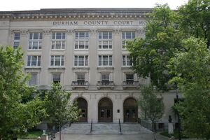
 Old Durham County Courthouse | |
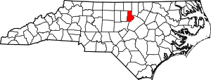
 الموقع ضمن ولاية North Carolina | |
 موقع North Carolina ضمن الولايات المتحدة | |
| الإحداثيات: 36°02′N 78°52′W / 36.04°N 78.87°W | |
| البلد | |
| State | |
| تأسست | 1881 |
| السمِيْ | Bartlett Snipes Durham |
| Seat | Durham |
| أكبر مدينة | Durham |
| المساحة | |
| • الإجمالي | 298 ميل² (770 كم²) |
| • البر | 286 ميل² (740 كم²) |
| • الماء | 12 ميل² (30 كم²) 4.0%% |
| التعداد | |
| • Estimate (2019) | 321٬488 |
| • الكثافة | 1٬015٫4/sq mi (392�0/km2) |
| منطقة التوقيت | UTC−5 (Eastern) |
| • الصيف (التوقيت الصيفي) | UTC−4 (EDT) |
| Congressional districts | 1st، 4th |
| الموقع الإلكتروني | www |
مقاطعة درم إنگليزية: Durham County هي إحدى مقاطعات ولاية كارولاينا الشمالية في الولايات المتحدة. مركز المقاطعة أو مقعدها هي مدينة دورهام. تأسست هذه المقاطعة سنة 1881.أصل هذه المقاطعة يأتي من: مقاطعة أورانج ومقاطعة ويك.
Durham County is the core of the Durham-Chapel Hill, NC Metropolitan Statistical Area, which is also included in the Raleigh-Durham-Cary, NC Combined Statistical Area, which had a population of 1,749,525 in 2010.
المقاطعات المجاورة
- Person County - north
- Granville County - northeast
- Wake County - east and southeast
- Chatham County - south
- Orange County - west
Major highways
- Invalid type: I
- Invalid type: I
- Invalid type: I / Invalid type: NC
- Invalid type: US
- Invalid type: US
- Invalid type: US
- Invalid type: NC
- Invalid type: NC
- Invalid type: NC
- Invalid type: NC
- Invalid type: NC
- Invalid type: NC
الديمغرافيا
| التعداد | Pop. | ملاحظة | %± |
|---|---|---|---|
| 1890 | 18٬041 | — | |
| 1900 | 26٬233 | 45٫4% | |
| 1910 | 35٬276 | 34٫5% | |
| 1920 | 42٬219 | 19٫7% | |
| 1930 | 67٬196 | 59٫2% | |
| 1940 | 80٬244 | 19٫4% | |
| 1950 | 101٬639 | 26٫7% | |
| 1960 | 111٬995 | 10٫2% | |
| 1970 | 132٬681 | 18٫5% | |
| 1980 | 152٬785 | 15٫2% | |
| 1990 | 181٬835 | 19�0% | |
| 2000 | 223٬314 | 22٫8% | |
| 2010 | 267٬587 | 19٫8% | |
| 2019 (تق.) | 321٬488 | [1] | 20٫1% |
| U.S. Decennial Census[2] 1790-1960[3] 1900-1990[4] 1990-2000[5] 2010-2013[6] | |||
Law and government
Durham County is a member of the regional Triangle J Council of Governments. Durham County is governed by a five-member board of county commissioners, currently consisting of Chair Wendy Jacobs, Vice Chair James Hill, Brenda A. Howerton, Heidi Carter, and Ellen W. Reckhow.[7] Each elected member serves a four-year term.
| Year | Republican | Democratic | Third parties |
|---|---|---|---|
| 2020 | 18.0% 32,459 | 80.4% 144,688 | 1.5% 2,767 |
| 2016 | 18.2% 28,350 | 77.7% 121,250 | 4.2% 6,534 |
| 2012 | 23.0% 33,769 | 75.8% 111,224 | 1.2% 1,742 |
| 2008 | 23.6% 32,353 | 75.6% 103,456 | 0.8% 1,088 |
| 2004 | 31.6% 34,614 | 68.0% 74,524 | 0.5% 513 |
| 2000 | 35.6% 30,150 | 63.7% 53,907 | 0.7% 547 |
| 1996 | 34.4% 27,825 | 60.8% 49,186 | 4.8% 3,899 |
| 1992 | 33.4% 27,581 | 57.2% 47,331 | 9.4% 7,770 |
| 1988 | 45.4% 29,928 | 53.8% 35,441 | 0.8% 514 |
| 1984 | 47.4% 29,185 | 52.4% 32,244 | 0.3% 155 |
| 1980 | 40.2% 19,276 | 52.1% 24,969 | 7.6% 3,656 |
| 1976 | 45.6% 18,945 | 54.0% 22,425 | 0.4% 163 |
| 1972 | 61.4% 25,576 | 37.4% 15,566 | 1.3% 525 |
| 1968 | 29.7% 12,705 | 38.7% 16,563 | 31.6% 13,542 |
| 1964 | 40.0% 15,264 | 60.0% 22,874 | |
| 1960 | 42.6% 14,322 | 57.4% 19,298 | |
| 1956 | 48.9% 13,226 | 51.1% 13,835 | |
| 1952 | 37.4% 11,301 | 62.6% 18,897 | |
| 1948 | 25.7% 4,531 | 65.5% 11,530 | 8.8% 1,552 |
| 1944 | 22.4% 3,690 | 77.6% 12,763 | |
| 1940 | 14.4% 2,491 | 85.6% 14,810 | |
| 1936 | 14.6% 2,189 | 85.4% 12,804 | |
| 1932 | 25.9% 2,770 | 70.8% 7,559 | 3.3% 351 |
| 1928 | 66.1% 8,723 | 33.9% 4,482 | |
| 1924 | 38.0% 3,093 | 59.3% 4,837 | 2.7% 221 |
| 1920 | 43.3% 3,550 | 56.7% 4,646 | |
| 1916 | 42.7% 1,837 | 57.3% 2,463 | |
| 1912 | 3.5% 124 | 62.3% 2,197 | 34.2% 1,205 |
| 1908 | 49.3% 1,820 | 50.4% 1,859 | 0.2% 9 |
| 1904 | 40.1% 1,080 | 59.5% 1,603 | 0.3% 10 |
| 1900 | 45.8% 2,026 | 53.7% 2,373 | 0.4% 19 |
| 1896 | 43.6% 1,924 | 55.2% 2,435 | 1.1% 52 |
| 1892 | 35.9% 1,264 | 42.3% 1,490 | 21.7% 764 |
| 1888 | 45.7% 1,618 | 51.9% 1,835 | 2.3% 82 |
| 1884 | 43.1% 1,193 | 56.9% 1,595 | 0.0% 0 |
Communities
The city of Durham is the only incorporated municipality to predominantly exist within Durham County, and the only one whose urban core lies within the county, though small portions of municipalities from neighboring counties extend into Durham County, and the city of Durham also itself extends slightly into neighboring counties. All other towns and places within Durham County are unincorporated communities.
Cities
- Durham (county seat, small portions extend into Wake and Orange counties)
- Raleigh (small part, mostly in Wake County)[9]
Towns
- Chapel Hill (small part, mostly in Orange County)
- Morrisville (small part, mostly in Wake County)
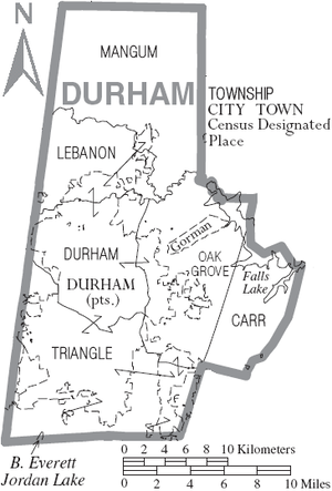
Townships
Census-designated places
- Gorman
- Rougemont (small portions extend into neighboring Person County)
Unincorporated communities
See also
References
- ^ "Population and Housing Unit Estimates". Retrieved March 28, 2020.
- ^ "U.S. Decennial Census". United States Census Bureau. Retrieved January 14, 2015.
- ^ "Historical Census Browser". University of Virginia Library. Retrieved January 14, 2015.
- ^ Forstall, Richard L., ed. (March 27, 1995). "Population of Counties by Decennial Census: 1900 to 1990". United States Census Bureau. Retrieved January 14, 2015.
- ^ "Census 2000 PHC-T-4. Ranking Tables for Counties: 1990 and 2000" (PDF). United States Census Bureau. April 2, 2001. Retrieved January 14, 2015.
- ^ خطأ استشهاد: وسم
<ref>غير صحيح؛ لا نص تم توفيره للمراجع المسماةQF - ^ [1][dead link]
- ^ Leip, David. "Dave Leip's Atlas of U.S. Presidential Elections". uselectionatlas.org. Retrieved 2018-03-15.
- ^ Raleigh Durham Annexation Agreement Lines Archived أكتوبر 19, 2011 at the Wayback Machine
External links
- Durham County Government official website
- Durham Convention and Visitors Bureau
- Durham County Library website
- Greater Durham Chamber of Commerce
- North Carolina Room of the Durham County Library Website for an archive which collects materials concerning the city and county of Durham

|
Granville County | Person County | 
| |
| Orange County | ||||
| Wake County | Chatham County |
- Pages using gadget WikiMiniAtlas
- Articles with dead external links from March 2018
- Short description is different from Wikidata
- Coordinates on Wikidata
- مقاطعات North Carolina
- Articles containing إنگليزية-language text
- Pages using Lang-xx templates
- Jct template errors
- Pages using US Census population needing update
- Durham County, North Carolina
- 1881 establishments in North Carolina
- Populated places established in 1881


