مقاطعة ألگيني، كارولاينا الشمالية
Alleghany County | |
|---|---|
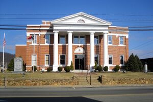
 Alleghany County Courthouse | |
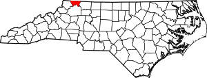
 الموقع ضمن ولاية North Carolina | |
 موقع North Carolina ضمن الولايات المتحدة | |
| الإحداثيات: 36°29′N 81°08′W / 36.49°N 81.13°W | |
| البلد | |
| State | |
| تأسست | 1859 |
| السمِيْ | Alleghany Mountains |
| Seat | Sparta |
| أكبر town | Sparta |
| المساحة | |
| • الإجمالي | 237 ميل² (610 كم²) |
| • البر | 235 ميل² (610 كم²) |
| • الماء | 1٫5 ميل² (4 كم²) 0.6%% |
| التعداد | |
| • Estimate (2019) | 11٬137 |
| • الكثافة | 47/sq mi (18/km2) |
| منطقة التوقيت | UTC−5 (Eastern) |
| • الصيف (التوقيت الصيفي) | UTC−4 (EDT) |
| Congressional district | 5th |
| الموقع الإلكتروني | www |
مقاطعة ألگيني أو أليغاني (إنگليزية: Alleghany County ؛ /ælɪˈɡeɪniː/[1]) هي إحدى مقاطعات ولاية كارولاينا الشمالية في الولايات المتحدة الأمريكية. مركز المقاطعة أو مقعدها هي مدينة سبارتا. تأسست هذه المقاطعة سنة 1859. اقتطعت المقاطعة من مقاطعة آش.
المقاطعات المجاورة
- Grayson County, Virginia - شمال
- Surry County - شرق
- Wilkes County - جنوب
- Ashe County - غرب
القانون والحكم
Alleghany County is a member of the regional High Country Council of Governments.
نتائج الانتخابات الرئاسية
| Year | Republican | Democratic | Third parties |
|---|---|---|---|
| 2016 | 71.8% 3,814 | 24.6% 1,306 | 3.7% 195 |
| 2012 | 66.9% 3,390 | 31.2% 1,583 | 1.9% 94 |
| 2008 | 59.4% 3,124 | 38.4% 2,021 | 2.2% 118 |
| 2004 | 59.7% 2,883 | 39.8% 1,922 | 0.5% 22 |
| 2000 | 58.7% 2,531 | 39.8% 1,715 | 1.6% 67 |
| 1996 | 45.7% 1,936 | 42.5% 1,801 | 11.8% 498 |
| 1992 | 39.2% 1,853 | 48.0% 2,271 | 12.8% 606 |
| 1988 | 51.0% 2,174 | 48.9% 2,087 | 0.1% 3 |
| 1984 | 56.1% 2,589 | 43.6% 2,013 | 0.3% 15 |
| 1980 | 46.3% 1,995 | 51.0% 2,198 | 2.7% 117 |
| 1976 | 37.4% 1,532 | 62.3% 2,550 | 0.3% 14 |
| 1972 | 61.3% 2,158 | 37.0% 1,304 | 1.7% 59 |
| 1968 | 45.8% 1,695 | 29.8% 1,102 | 24.4% 904 |
| 1964 | 39.9% 1,573 | 60.1% 2,368 | |
| 1960 | 48.3% 1,978 | 51.7% 2,121 | |
| 1956 | 50.4% 1,699 | 49.6% 1,670 | |
| 1952 | 49.7% 1,789 | 50.3% 1,809 | |
| 1948 | 42.4% 1,374 | 51.4% 1,667 | 6.2% 200 |
| 1944 | 45.2% 1,495 | 54.8% 1,810 | |
| 1940 | 38.4% 1,217 | 61.6% 1,952 | |
| 1936 | 39.0% 1,498 | 61.0% 2,345 | |
| 1932 | 29.2% 810 | 70.3% 1,951 | 0.5% 15 |
| 1928 | 49.2% 1,368 | 50.8% 1,414 | |
| 1924 | 42.8% 1,234 | 57.0% 1,643 | 0.2% 6 |
| 1920 | 46.0% 1,201 | 54.0% 1,409 | |
| 1916 | 44.6% 641 | 55.4% 796 | |
| 1912 | 18.6% 208 | 58.4% 652 | 22.9% 256 |
الديمغرافيا
| التعداد | Pop. | ملاحظة | %± |
|---|---|---|---|
| 1860 | 3٬590 | — | |
| 1870 | 3٬691 | 2٫8% | |
| 1880 | 5٬486 | 48٫6% | |
| 1890 | 6٬523 | 18٫9% | |
| 1900 | 7٬759 | 18٫9% | |
| 1910 | 7٬745 | −0٫2% | |
| 1920 | 7٬403 | −4٫4% | |
| 1930 | 7٬186 | −2٫9% | |
| 1940 | 8٬341 | 16٫1% | |
| 1950 | 8٬155 | −2٫2% | |
| 1960 | 7٬734 | −5٫2% | |
| 1970 | 8٬134 | 5٫2% | |
| 1980 | 9٬587 | 17٫9% | |
| 1990 | 9٬590 | 0�0% | |
| 2000 | 10٬677 | 11٫3% | |
| 2010 | 11٬155 | 4٫5% | |
| 2019 (تق.) | 11٬137 | [3] | −0٫2% |
| U.S. Decennial Census[4] 1790-1960[5] 1900-1990[6] 1990-2000[7] 2010-2013[8] | |||
الهامش
- ^ Talk Like A Tarheel Archived 2013-06-22 at the Wayback Machine, from the North Carolina Collection website at the University of North Carolina at Chapel Hill. Retrieved 2013-01-29.
- ^ Leip, David. "Dave Leip's Atlas of U.S. Presidential Elections". uselectionatlas.org. Retrieved 2018-03-14.
- ^ "Population and Housing Unit Estimates". Retrieved April 30, 2020.
- ^ "U.S. Decennial Census". United States Census Bureau. Retrieved January 11, 2015.
- ^ "Historical Census Browser". University of Virginia Library. Retrieved January 11, 2015.
- ^ Forstall, Richard L., ed. (March 27, 1995). "Population of Counties by Decennial Census: 1900 to 1990". United States Census Bureau. Retrieved January 11, 2015.
- ^ "Census 2000 PHC-T-4. Ranking Tables for Counties: 1990 and 2000" (PDF). United States Census Bureau. April 2, 2001. Retrieved January 11, 2015.
- ^ خطأ استشهاد: وسم
<ref>غير صحيح؛ لا نص تم توفيره للمراجع المسماةQF
وصلات خارجية

|
Grayson County, Virginia | 
| ||
| Surry County | Ashe County | |||
| Wilkes County |
الكلمات الدالة:
?
تصنيفات:
- Pages using gadget WikiMiniAtlas
- Short description is different from Wikidata
- Coordinates on Wikidata
- مقاطعات North Carolina
- Articles containing إنگليزية-language text
- Pages using Lang-xx templates
- Pages using US Census population needing update
- مقاطعة ألگيني، كارولاينا الشمالية
- تأسيسات 1859 في كارولاينا الشمالية
- غرب كارولاينا الشمالية
- مقاطعات أپالاشيا
- أماكن مأهولة تأسست في 1859

