لنكشر
(تم التحويل من لانكشاير)
لانكشاير Lancashire | |
|---|---|
 The Red Rose of Lancaster is the county flower of Lancashire, and a common symbol for the county. | |
 | |
| البلد | المملكة المتحدة |
| المقاطعة | إنگلترة |
| التأسيس | c. 1182[1] |
| Time zone | UTC±00:00 (توقيت گرينتش المتوسط) |
| • Summer (DST) | UTC+01:00 (توقيت بريطانيا الصيفي) |
| المقاطعة الاحتفالية | |
| المساحة | 3،079 km2 (1،189 sq mi) |
| الترتيب | 17th من 48 |
| الترتيب | من 48 |
| الكثافة السكانية | [convert: needs a number] |
| العرقية | 89.7% بريطانيون بيض 6.0% S. آسيويون 2.1% بيض آخرون 0.9% مختلطون 0.7% آسيويون وآخرون 0.5% سود تعداد 2005 |
لانكشاير Lancashire (/ˈlæŋkəʃər/ أو أقل شيوعاً، /ˈlæŋkəʃɪər/)، هي مقاطعة صغرى تاريخية في منطقة شمال غرب إنگلترة. اتخذت اسمها من مدينة لانكستر، التي تعرف أحياناً باسم مقاطعة لانكستر.[2] بالرغم من أن لانكستر لاتزال تعتبر بلدة المقاطعة، إلا أن مجلس مقاطعة لانكشاير يقع في پرستن. عدد سكان المقاطعة 1.448.300 نسمة.
التاريخ
التاريخ المبكر
التاريخ المعاصر

الجغرافيا
التقسيمات
الجيولوجيا، الأفق والبيئة
 مقالة مفصلة: جيولوجيا لانكشاير

السياسة
الدوائر الانتخابية
| الانتخابات العامة 2010 : لانكشاير | ||||||||||||||
|---|---|---|---|---|---|---|---|---|---|---|---|---|---|---|
| المحافظون | Labour | الديمقراطيون الليبراليون | UKIP | BNP | آخرون | الخضر | الديمقراطيون الإنگليز | الجبهة القومية | التيار المسيحي | الحزب المسيحي | حزب مونستر ريڤنگ لوني | الإقبال | ||
| 276,408 +48,457 |
250,837 −18,871 |
129,001 +18,381 |
27,379 +11,417 |
15,966 +3,596 |
6,091 +2,862 |
4,088 +1,810 |
1,076 N/A |
1,062 N/A |
795 N/A |
413 N/A |
198 N/A |
713,314 +70,418 | ||
| إجمالي المقاعد في 2010 | |||||||||||||
|---|---|---|---|---|---|---|---|---|---|---|---|---|---|
| المحافظون | Labour | الديمقراطيون الليبراليون | UKIP | BNP | Others | الخضر | الديمقراطيون الإنگليز | الجبهة الوطنية | Christian People's Alliance | الحزب المسيحي | Monster Raving Loony Party | ||
| 9 | 5 | 1 | 0 | 0 | 0 | 0 | 0 | 0 | 0 | 0 | 0 | ||
مجلس المقاطعة
| Election | عدد أعضاء المجلس المنتخبون حسب الحزب السياسي | ||||||
|---|---|---|---|---|---|---|---|
| العمال | حزب لمحافظين | Liberal Democrats | مستقلون | حزب الخضر | |||
| 2013 | 39 | 35 | 6 | 3 | 1 | ||
دوقية لانكستر
الاقتصاد

العائد الاقتصادي

| السنة | القيمة الإجمالية المحلية المضافة[3] | الزراعة[4] | الصناعة[5] | الخدمات[6] |
|---|---|---|---|---|
| 1995 | 13,789 | 344 | 5,461 | 7,984 |
| 2000 | 16,584 | 259 | 6,097 | 10,229 |
| 2003 | 19,206 | 294 | 6,352 | 12,560 |
التعليم
النقل
النقل البري

السكك الحديدية

Railways in Lancashire
Primary route
Secondary route
Rural route
Goods only
Disused railway
النقل الجوية
العبارات
الحافلات
الديموغرافيا

التغير السكاني
| إجمالي سكان مقاطعة لانكشاير المعاصرة (قبل-1998) | |||||||
|---|---|---|---|---|---|---|---|
| السنة | السكان | السنة | السكان | السنة | السكان | ||
| 1801 | 163,310 | 1871 | 524,869 | 1941 | 922,812 | ||
| 1811 | 192,283 | 1881 | 630,323 | 1951 | 948,592 | ||
| 1821 | 236,724 | 1891 | 736,233 | 1961 | 991,648 | ||
| 1831 | 261,710 | 1901 | 798,545 | 1971 | 1,049,013 | ||
| 1841 | 289,925 | 1911 | 873,210 | 1981 | 1,076,146 | ||
| 1851 | 313,957 | 1921 | 886,114 | 1991 | 1,122,097 | ||
| 1861 | 419,412 | 1931 | 902,965 | 2001 | 1,134,976 | ||
| Pre-1998 statistics were gathered from local government areas that now comprise Lancashire Source: Great Britain Historical GIS.[7] | |||||||
المدن
المناطق


- † – part of the West Riding of Yorkshire until 1974
'

مناطق تاريخية
| مانشستر الكبرى | Ashton-in-Makerfield, Ashton-under-Lyne, Bolton, Bury, Chadderton, Denton, Eccles, Farnworth, Heywood, Horwich, Hindley, Irlam, Kearsley, Leigh, Little Lever, Manchester, Middleton, Oldham, Prestwich, Radcliffe, Rochdale, Salford, Stretford, Swinton and Pendlebury, Tyldesley, Urmston, Westhoughton, Whitefield, Wigan, Worsley. |
|---|---|
| مرسيسايد | Bootle, Crosby, Formby, Huyton, Kirkby, Liverpool, Maghull, Newton-le-Willows, Prescot, St Helens, Southport |
| كمبريا | Barrow-in-Furness, Coniston, Dalton-in-Furness, Grange-over-Sands, Ulverston |
| تششر | Warrington, Widnes |
| غرب يوركشاير | Todmorden |
حدث تغير الحدود قبل 1974:[8]
الرموز
الرياضة
الموسيقى

المطبخ


أشهر الأماكن
| المفتاح | |
| كنيسة/كاتدرائية | |
| منطقة مفتوحة للمعاقين | |
| منتزه ترفيهي/حديقة ملاهي | |
| قلعة | |
| منتزه المقاطعة | |
| تراث إنگليزي | |
| هيئة الغابات | |
| سكك حديدية تراثية | |
| بيت تاريخي | |
| متحف (مجاني/غير مجاني) | |
| صندوق وطني | |
| مسرح | |
| حديقة حيوان | |
-
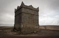
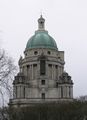 The Ashton Memorial, Lancaster
 -
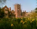 Bank Hall, Bretherton, a Jacobean mansion house, awaiting restoration. Home to Lancashire's oldest Yew tree and one of the two fallen sequoia in the UK.
 -
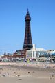 Blackpool Tower, completed in 1894
 -
-
 Rivington Pike, near Horwich, a top of the West Pennine Moors is one of the most popular walking destinations in the county, on a clear day the whole of the county can be viewed from here
 -
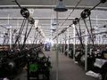 Queen Street Mill, the worlds only surviving steam driven cotton weaving shed located in Burnley.


السينما
انظر أيضاً
- Custos Rotulorum of Lancashire - Keepers of the Rolls
- High Sheriff of Lancashire
- لانكشاير (دائرة انتخابية في المملة المتحدة) - قائمة تاريخية لأعضاء البرلمان
- لهجة لانكشاير
- Lord Lieutenant of Lancashire
الهوامش والمصادر
- ^ "Lancashire: county history". The High Sheriff's Association of England and Wales. 2010. Retrieved 30 December 2015.
- ^ Vision of Britain – Lancashire
- ^ المكونات قد تكون غير مضافة للإجمالي لأنها مقربة
- ^ تشمل الصيد والغابات
- ^ تشمل الطاقة والإنشاءات
- ^ تشمل خدمات الوساطة المالية المقاسة بطريقة غير مباشرة
- ^ A Vision of Britain through time, Lancashire Modern (post 1974) County: Total Population, http://www.visionofbritain.org.uk/data_cube_page.jsp?data_theme=T_POP&data_cube=N_TOT_POP&u_id=10097848&c_id=10001043&add=N, retrieved on 2010-01-10
- ^ خطأ استشهاد: وسم
<ref>غير صحيح؛ لا نص تم توفيره للمراجع المسماةYoungs
المراجع
- Crosby, A. (1996). A History of Cheshire. (The Darwen County History Series.) Chichester, West Sussex, UK: Phillimore & Co. Ltd. ISBN 0-85033-932-4.
- Harris, B. E., and Thacker, A. T. (1987). The Victoria History of the County of Chester. (Volume 1: Physique, Prehistory, Roman, Anglo-Saxon, and Domesday). Oxford: Oxford University Press. ISBN 0-19-722761-9.
- Morgan, P. (1978). Domesday Book Cheshire: Including Lancashire, Cumbria, and North Wales. Chichester, Sussex: Phillimore & Co. Ltd. ISBN 0-85033-140-4.
- Phillips A. D. M., and Phillips, C. B. (2002), A New Historical Atlas of Cheshire. Chester, UK: Cheshire County Council and Cheshire Community Council Publications Trust. ISBN 0-904532-46-1.
- Sylvester, D. (1980). A History of Cheshire. (The Darwen County History Series). (2nd Edition.) London and Chichester, Sussex: Phillimore & Co. Ltd. ISBN 0-85033-384-9.
قراءات إضافية
- Farrer and Brownbill, The Victoria history of the county of Lancaster Vol 1 (1906); Vol 2 (1908); Vol 3 (1907); Vol 4 (1911); Vol 5 (1911); Vol 6 (1911); Vol 7 (1911); London: Constable.
وصلات خارجية
- Lancashire On Line Parish Clerk an active project to transcribe and publish records of Births, Marriages and Deaths in Lancashire from the time records began in Edward VIths reign
- Traditions of Lancashire, Volume 1 (of 2), by John Roby
- Lancashire Lantern, The Lancashire Life and Times E-Resource network
- Website of the film 'Catch - the hold not taken', a look at the cultural significance of wrestling in Lancashire
- Lancashire County Council – MARIO (Mapping portal)
- Map of Lancashire
- Government Office for the North West
- North West Regional Minister
- Lancashire Online Forums
- Images of Lancashire at the English Heritage Archive
53°48′N 2°36′W / 53.8°N 2.6°W
| تششاير |  | |
|---|---|---|
| كمبريا | Allerdale • Barrow-in-Furness • Carlisle • Copeland • إدن • South Lakeland | |
| مانشستر الكبرى | ||
| لانكشاير | Blackburn with Darwen • Blackpool • Burnley • Chorley • Fylde • Hyndburn • لانكستر • Pendle • Preston • Ribble Valley • Rossendale • South Ribble • غرب لانكستر • Wyre | |
| مرسياسايد | ||
الكلمات الدالة:
تصنيفات:
- Pages using gadget WikiMiniAtlas
- Short description is different from Wikidata
- Convert errors
- Pages using infobox settlement with no coordinates
- Articles with hatnote templates targeting a nonexistent page
- Coordinates on Wikidata
- تأسيسات 1182
- لانكشاير
- مقاطعات صغرى
- شمال غرب إنگلترة
- مقاطعات إنگلترة
- أقاليم التصنيف الثاني في المملكة المتحدة