ستافوردشاير
Staffordshire | |||||||||||||||||||||||||||||||||||||||||||||||||||||||||
|---|---|---|---|---|---|---|---|---|---|---|---|---|---|---|---|---|---|---|---|---|---|---|---|---|---|---|---|---|---|---|---|---|---|---|---|---|---|---|---|---|---|---|---|---|---|---|---|---|---|---|---|---|---|---|---|---|---|
 Flag  Coat of arms | |||||||||||||||||||||||||||||||||||||||||||||||||||||||||
| الشعار: The knot unites | |||||||||||||||||||||||||||||||||||||||||||||||||||||||||
 | |||||||||||||||||||||||||||||||||||||||||||||||||||||||||
| الإحداثيات: 52°50′N 2°00′W / 52.833°N 2.000°W | |||||||||||||||||||||||||||||||||||||||||||||||||||||||||
| البلد | المملكة المتحدة | ||||||||||||||||||||||||||||||||||||||||||||||||||||||||
| المقاطعة | إنگلترة | ||||||||||||||||||||||||||||||||||||||||||||||||||||||||
| المنطقة | West Midlands | ||||||||||||||||||||||||||||||||||||||||||||||||||||||||
| التأسيس | Ancient | ||||||||||||||||||||||||||||||||||||||||||||||||||||||||
| منطقة التوقيت | UTC±00:00 (توقيت گرينتش المتوسط) | ||||||||||||||||||||||||||||||||||||||||||||||||||||||||
| • الصيف (التوقيت الصيفي) | UTC+01:00 (توقيت بريطانيا الصيفي) | ||||||||||||||||||||||||||||||||||||||||||||||||||||||||
| أعضاء البرلمان | List of MPs | ||||||||||||||||||||||||||||||||||||||||||||||||||||||||
| الشرطة | Staffordshire Police | ||||||||||||||||||||||||||||||||||||||||||||||||||||||||
| |||||||||||||||||||||||||||||||||||||||||||||||||||||||||

Staffordshire (/ˈstæfərdˌʃɪər, -ʃər/;[2] postal abbreviation Staffs.) is a landlocked county in the West Midlands of England. It borders Cheshire to the northwest, Derbyshire and Leicestershire to the east, Warwickshire to the southeast, West Midlands and Worcestershire to the south, and Shropshire to the west.
The largest settlement in Staffordshire is Stoke-on-Trent, which is administered as an independent unitary authority, separately from the rest of the county. Lichfield, a smaller settlement, is a cathedral city. Other major settlements include Stafford, Burton upon Trent, Cannock, Newcastle-under-Lyme, Rugeley, Leek, and Tamworth.
Smaller towns include Stone, Cheadle, Uttoxeter, Burntwood/Chasetown, Eccleshall, Biddulph, Penkridge and the large villages of Wombourne, Kinver, Tutbury, Alrewas, Barton-under-Needwood, Stretton and Abbots Bromley. Cannock Chase AONB is within the county as well as parts of the National Forest and the Peak District national park.
Wolverhampton, Walsall, West Bromwich and Smethwick are within the historic county boundaries of Staffordshire, but since 1974 have been part of the West Midlands county.
Apart from Stoke-on-Trent, Staffordshire is divided into the districts of Cannock Chase, East Staffordshire, Lichfield, Newcastle-under-Lyme, South Staffordshire, Stafford, Staffordshire Moorlands, and Tamworth.
التاريخ

Historically, Staffordshire was divided into five hundreds: Cuttlestone, Offlow, Pirehill, Seisdon, and Totmonslow.

Economy

This is a chart of trend of regional gross value added of the non-metropolitan county of Staffordshire at current basic prices published (pp. 240–253) by Office for National Statistics with figures in millions of British pounds sterling.
| Year | Regional gross value added[3] | Agriculture[4] | Industry[5] | Services[6] |
|---|---|---|---|---|
| 1995 | 6,447 | 209 | 2,349 | 3,889 |
| 2000 | 8,621 | 150 | 2,986 | 5,485 |
| 2003 | 10,169 | 169 | 3,164 | 6,835 |
الجغرافيا

الحكم
Staffordshire County Council is the top-tier local council for the non-metropolitan county. For Eurostat purposes, it is a NUTS 3 region (code UKG22).
Staffordshire operates a cabinet-style council. There are 62 councillors for Staffordshire. The Full Council elects a cabinet of 10 councillors, including the council leader, from the majority party. Each cabinet member has their own portfolio about which they make the "day to day" decisions.[7][8]
Latest Council election results
| 2017 Staffordshire County Council election | |||||||||||
|---|---|---|---|---|---|---|---|---|---|---|---|
| الحزب | المقاعد | فاز | خسر | الفوز/المكسب الصافي | المقاعد% | الأصوات% | الأصوات | +/− | |||
| حزب المحافظين | 51 | {{{net seats %}}} | {{{votes R1}}} | {{{votes % R1}}} | {{{net % R1}}} | {{{votes R2}}} | {{{votes % R2}}} | {{{net % R2}}} | |||
| حزب العمال | 10 | {{{net seats %}}} | {{{votes R1}}} | {{{votes % R1}}} | {{{net % R1}}} | {{{votes R2}}} | {{{votes % R2}}} | {{{net % R2}}} | |||
| UKIP | 0 | {{{net seats %}}} | {{{votes R1}}} | {{{votes % R1}}} | {{{net % R1}}} | {{{votes R2}}} | {{{votes % R2}}} | {{{net % R2}}} | |||
| مستقل | 1 | {{{net seats %}}} | {{{votes R1}}} | {{{votes % R1}}} | {{{net % R1}}} | {{{votes R2}}} | {{{votes % R2}}} | {{{net % R2}}} | |||
Boundary changes
Areas
Areas


Historic towns/cities
Some settlements which were historically part of the county now fall under the West Midlands county:
| West Midlands | Aldridge, Bilston, Bloxwich, Brierley Hill, Brownhills, Coseley, Darlaston, Harborne, Kingswinford, Pelsall, Rowley Regis, Sedgley, Smethwick, Tipton, Walsall, Wednesbury, Wednesfield, West Bromwich, Willenhall, Wolverhampton |
|---|
الدين
الإسلام
There are 15 mosques in Stoke-on-Trent, 5 in Burton-upon-Trent and 1 in both Stafford and Lichfield.[9] A new mosque[10][11][12] is under constructionقالب:As of when? in the Hanley area of Stoke-on-Trent and will be the first purpose-built mosque in the area. At the 2001 census there were 7,658 Muslims in Stoke-on-Trent and 6,081 in the rest of Staffordshire, with a total of 13,739 making up 1.3% of the population. 62.9% (3823) of the Muslims in the rest of Staffordshire are from the town of Burton-upon-Trent.[13][14][15][16][17][18][19][20]
Places of interest
| المفتاح | |
| كنيسة/كاتدرائية | |
| منطقة مفتوحة للمعاقين | |
| منتزه ترفيهي/حديقة ملاهي | |
| قلعة | |
| منتزه المقاطعة | |
| تراث إنگليزي | |
| هيئة الغابات | |
| سكك حديدية تراثية | |
| بيت تاريخي | |
| متحف (مجاني/غير مجاني) | |
| صندوق وطني | |
| مسرح | |
| حديقة حيوان | |
- Alton Towers

- Ancient High House


- Apedale Community Country Park


- Biddulph Grange

- Blithfield Hall
- Blithfield Reservoir

- Brindley Water Mill

- Broad Eye Windmill
- Cannock Chase
- Chasewater Railway
- Cheddleton Flint Mill
- Churnet Valley Railway
- Croxden Abbey


- Downs Banks
- Drayton Manor Theme Park
- Eccleshall Castle

- Erasmus Darwin House
- Ford Green Hall
- Foxfield Steam Railway
- Gladstone Pottery Museum
- Hanley Park
- Heart of England Way
- Moseley Railway Trust (Apedale)
- Ilam Park
- Izaak Walton's Cottage
- Manifold Way following the route of the former Leek and Manifold Valley Light Railway
- National Brewery Centre
- Lichfield Cathedral
- Madeley Old Hall
- Monkey Forest at Trentham Gardens

- Moseley Old Hall
- Mow Cop Castle
- National Memorial Arboretum
- Peak District National Park
- RSPB Coombes Valley
- Rudyard Lake Steam Railway
- Sandon Hall
- Shugborough Estate
- Stafford Castle
- Staffordshire Regiment Museum
- Staffordshire Way
- Potteries Museum & Art Gallery
- Pennine Way
- The Roaches
- Tamworth Castle
- Trentham Gardens
- Tutbury Castle
- Victoria Park, Stafford
- Wall Roman Site
- Wedgwood Museum
- Weston Park
- Whitmore Hall
Gallery
Map of Staffordshire and its hundreds by Wenceslas Hollar some time between 1627–1677.
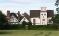
Boscobel House.
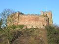
Tamworth Castle.
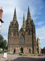
Lichfield Cathedral.
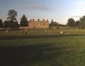
Weston Park
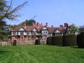
Wightwick Manor
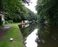
The Staffordshire & Worcestershire Canal.
.jpg&filetimestamp=20200628112259&)


See also
- Lord Lieutenant of Staffordshire
- High Sheriff of Staffordshire
- List of MPs for Staffordshire
- Samuel Hieronymus Grimm
- The Stafford knot
- Tamworth Pig
- Healthcare in Staffordshire
- Staffordshire Police
- Staffordshire Police and Crime Commissioner
References
- ^ "No. 62943". The London Gazette. 13 مارس 2020. p. 5161.
- ^ "Staffordshire". Collins Dictionary. n.d. Archived from the original on 3 مارس 2016. Retrieved 29 مايو 2020.
- ^ Components may not sum to totals due to rounding
- ^ includes hunting and forestry
- ^ includes energy and construction
- ^ includes financial intermediation services indirectly measured
- ^ "Role of County Council". Staffordshire County Council. Archived from the original on 1 ديسمبر 2008. Retrieved 5 مايو 2010.
- ^ "Role of the Cabinet". Staffordshire County Council. Archived from the original on 10 ديسمبر 2010. Retrieved 5 مايو 2010.
- ^ "Mosques in the United Kingdom". Mosques.muslimsinbritain.org. Archived from the original on 17 يوليو 2015. Retrieved 4 يونيو 2012.
- ^ Muslim, British (30 يناير 2009). "Mosque community centre plan unveiled". Thisisstaffordshire.co.uk. Archived from the original on 1 أكتوبر 2012. Retrieved 4 يونيو 2012.
- ^ "Four arrests over Stoke-on-Trent mosque arson". BBC. 3 ديسمبر 2010. Archived from the original on 8 مارس 2012. Retrieved 4 يونيو 2012.
- ^ "Stolen pipe used in Stoke-on-Trent mosque arson". BBC. 23 ديسمبر 2010. Archived from the original on 20 فبراير 2012. Retrieved 4 يونيو 2012.
- ^ Neighbourhood Statistics. "Horninglow Religion". Neighbourhood.statistics.gov.uk. Archived from the original on 12 سبتمبر 2012. Retrieved 4 يونيو 2012.
- ^ Neighbourhood Statistics. "Eton Park Religion". Neighbourhood.statistics.gov.uk. Archived from the original on 12 سبتمبر 2012. Retrieved 4 يونيو 2012.
- ^ Neighbourhood Statistics. "Burton Religion". Neighbourhood.statistics.gov.uk. Archived from the original on 12 سبتمبر 2012. Retrieved 4 يونيو 2012.
- ^ Neighbourhood Statistics. "Winshill Religion". Neighbourhood.statistics.gov.uk. Archived from the original on 12 سبتمبر 2012. Retrieved 4 يونيو 2012.
- ^ Neighbourhood Statistics. "Brizlincote Religion". Neighbourhood.statistics.gov.uk. Archived from the original on 12 سبتمبر 2012. Retrieved 4 يونيو 2012.
- ^ Neighbourhood Statistics. "Stapenhill Religion". Neighbourhood.statistics.gov.uk. Archived from the original on 12 سبتمبر 2012. Retrieved 4 يونيو 2012.
- ^ Neighbourhood Statistics. "Anglesey Religion". Neighbourhood.statistics.gov.uk. Archived from the original on 12 سبتمبر 2012. Retrieved 4 يونيو 2012.
- ^ Neighbourhood Statistics. "Shobnall Religion". Neighbourhood.statistics.gov.uk. Archived from the original on 12 سبتمبر 2012. Retrieved 4 يونيو 2012.
External links
| Staffordshire
]]. Chisholm, Hugh, ed. (1911). . دائرة المعارف البريطانية. Vol. 25 (eleventh ed.). Cambridge University Press.
 {{cite encyclopedia}}: Cite has empty unknown parameter:|coauthors=(help)- ستافوردشاير at the Open Directory Project
- East Staffordshire Community Website
- BBC Staffordshire website
- Staffordshire County Council
- Staffordshire Past Track – Historical archive about the county
- Staffordshire Tourism website
- The Staffordshire Encyclopaedia
- Images of Staffordshire at the English Heritage Archive
- The History of Parliament: the House of Commons - Staffordshire, County, 1386 to 1841

- Pages using gadget WikiMiniAtlas
- Articles with hatnote templates targeting a nonexistent page
- Missing redirects
- EngvarB from July 2014
- Use dmy dates from October 2014
- Short description is different from Wikidata
- Coordinates on Wikidata
- Pages with empty portal template
- مقالات المعرفة المحتوية على معلومات من دائرة المعارف البريطانية طبعة 1911
- ستافوردشاير
- Non-metropolitan counties
- غرب ميدلاندز (اقليم)
- NUTS 3 statistical regions of the United Kingdom