طرابزون
طرابزون
Trabzon | |
|---|---|
      من أعلى إلى أسفل ومن اليسار إلى اليمين: دير صوميلا كما يبدو عبر وادي ألتيندره؛ بيت أتاتورك؛ بحيرة أوزونگول; هاگيا صوفيا طرابزون؛ ميدان أتاتورك؛ منظر عام لوسط المدينة من بوزتپه. | |
 Emblem of Trabzon Metropolitan Municipality | |
 طرابزون موقع طرابزون في تركيا. | |
| Coordinates: 41°00′N 39°44′E / 41.000°N 39.733°E | |
| البلد | |
| المحافظة | طرابزون |
| Government | |
| • المحافظ | يوجل ياڤوز |
| • العمدة | أورهان فوزي گمركچيأوغلو (AKP) |
| Area | |
| • District | 188٫85 كم² (72٫92 ميل²) |
| Elevation | 0 m (0 ft) |
| Population (2012)[2] | |
| • Urban | 768٫417 |
| • District | 312٬060 |
| • District density | 1٬700/km2 (4٬300/sq mi) |
| Time zone | UTC+3 (FET) |
| الرمز البريدي | 61xxx |
| Area code | (+90) 462 |
| Licence plate | 61 |
| Climate | Cfa |
طرابزون ( Trabzon ؛ Ophitic Pontic Greek: Τραπεζούντα (Trapezounta); Georgian: ტრაპიზონი (Trapizoni)؛ بالأرمينية: Տրապիզոն)، هي عاصمة محافظة طرابزون تقع في شمال شرق تركيا على ساحل البحر الأسود ويبلغ تعداد سكانها حوالي 214,949 نسمة. Trabzon, located on the historical Silk Road, became a melting pot of religions, languages and culture for centuries and a trade gateway to Persia in the southeast and the Caucasus to the northeast.[3] The Venetian and Genoese merchants paid visits to Trabzon during the medieval period and sold silk, linen and woolen fabric. Both republics had merchant colonies within the city – Leonkastron and the former "Venetian castle" – that played a role to Trabzon similar to the one Galata played to Constantinople (modern Istanbul).[4] Trabzon formed the basis of several states in its long history and was the capital city of the Empire of Trebizond between 1204 and 1461. During the early modern period, Trabzon, because of the importance of its port, again became a focal point of trade to Persia and the Caucasus.
الاسم

The Turkish name of the city is Trabzon. It is historically known in English as Trebizond. In Latin, Trabzon was called Trapezus, which is the latinization of the Ancient Greek Τραπεζοῦς (Trapezous), the first name of the city. (τράπεζα meant "table" in Ancient Greek; note the table on the coin in the figure.) Both in اليونانية الپنطية واليونانية الحديثة، تـُدعى Τραπεζούντα (Trapezounta). In Ottoman Turkish and Persian, it is written as طربزون. During Ottoman times, Tara Bozan was also used.[5][6][7][8] Some western geographers used this name instead of the Latin Trebizond. In Laz it is known as ტამტრა (T'amt'ra) or T'rap'uzani,[9] in Georgian it is ტრაპიზონი (T'rap'izoni) and in Armenian it is Տրապիզոն Trapizon. The 19th-century Armenian travelling priest Byjiskian called the city by other, native names, including Hurşidabat and Ozinis.[10] Other versions of the name, which have incidentally been used in English literature as well, include: Trebizonde (بالفرنسية)، Trapezunt (Ge.), Trebisonda (Sp.), Trapesunta (It.),Trapisonda, Tribisonde, Terabesoun, Trabesun, Trabuzan, Trabizond و Tarabossan.
التاريخ
العصر الحديدي والقدم الكلاسيكي

.jpg&filetimestamp=20171026105030&)
The oldest area associated with the Kartvelians was northeastern Anatolia, including the العصر الحديدي monarchy of the Diauehi (early-Georgians), later known as the culturally important region of T’ao-Klarjeti, where they pre-dated the Hittites.[11][12][13]
الفترة البيزنطية
.jpg&filetimestamp=20171026105058&)

إثر هزيمة البيزنطيين في معركة ملاذكرد في 1071، وقعت طرابيزوند تحت حكم السلاجقة. This rule proved transient when an expert soldier and local aristocrat, Theodore Gabras took control of the city from the Turkish invaders, and regarded Trebizond, in the words of Anna Comnena, "as a prize which had fallen to his own lot" and ruled it as his own kingdom.[14] Supporting Comnena's assertion, Simon Bendall has identified a group of rare coins he believes were minted by Gabras and his successors.[15] Although he was killed by the Turks in 1098, other members of his family continued his de facto independent rule into the next century.
امبراطورية طرابيزوند
(now Ayasofya mosque & museum)


_-_WGA17878.jpg&filetimestamp=20171026105243&)
Fourth Crusade (1202–1204) and the Sack of Constantinople by the Latin Crusaders in April 1204 led to the dissolution of the Byzantine Empire. The Empire of Trebizond was formed in 1204 as one of the three Byzantine Greek successor states of the Byzantine Empire. Located at the far northeastern corner of Anatolia, it was the longest surviving of the Byzantine successor states. Geographically, the Empire of Trebizond consisted of little more than a narrow strip along the southern coast of the Black Sea, and not much further inland than the Pontic Mountains. However, the city gained great wealth from the taxes it levied on the goods traded between Persia and Europe via the Black Sea. The Mongol siege of Baghdad in 1258 diverted more trade caravans towards the city. Genoese and to a lesser extent Venetian traders regularly came to Trabzon. To secure their part of the Black Sea trade, the Genoese bought the coastal fortification "Leonkastron", just west of the winter harbour, in the year 1306.
One of the most famous persons to have visited the city in this period was Marco Polo, who ended his overland return journey at the port of Trebizond, and sailed to his hometown Venice with a ship; passing by Constantinople (Istanbul) on the way, which was retaken by the Byzantines in 1261. A year earlier, in 1260, Niccolò and Maffeo Polo (the father and uncle of Marco Polo) were residing in Constantinople, then the capital of the Latin Empire. They foresaw a political change, liquidated their assets into jewels and moved away.[16] Their decision proved wise, as Constantinople was recaptured in 1261 by Michael VIII Palaiologos, the ruler of the Empire of Nicaea, who promptly burned the Venetian quarter in the city and reestablished the Byzantine Empire. Captured Venetian citizens in Constantinople were blinded,[17] while many of those who managed to escape perished aboard overloaded refugee ships fleeing to other Venetian colonies in the Aegean Sea.
Constantinople remained the Byzantine capital until it was conquered by the Ottoman Sultan Mehmed II in 1453, who also conquered Trebizond eight years later, in 1461.

الفترة العثمانية
-
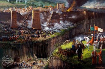 محمد الفاتح يقصف طرابزون 26 أكتوبر 1461.
 -
 فتح طرابزون على يد السلطان محمد الفاتح، في 26 أكتوبر 1461.
 -
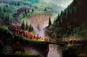
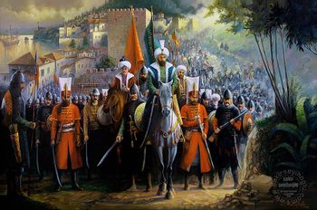 محمد الفاتح على رأس جيشه متجها إلى طرابزون.
 -
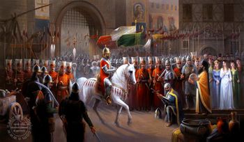 دافيد من طرابيزوند يسلم سيفه ومفتاح مدينة طرابزون للسلطان محمد الفاتح.

.jpg&filetimestamp=20171026114033&)


آخر أباطرة طرابيزوند، داڤيد، يسلـِّم المدينة للسلطان محمد الفاتح رأس الدولة العثمانية في 1461.[18] Following this takeover, Mehmed II sent many Turkish settlers into the area, but the old ethnic Greek, Laz and Armenian communities remained. According to the Ottoman tax books (تحرير دفترلري), the total population of adult males in the city was 1,473 in the year 1523.[19] Approximately 85% of them (1,252 adult males) were Christian, 13% of whom (197 adult males) were Armenian, and 15% of them (221 adult males) were Muslim.[19] However, a large portion of the local Christians were Islamized and Turkified by the end of the 17th century, according to a research by Prof. Halil İnalcık on the tax books (tahrir defterleri) of the Ottoman Empire. Trabzon was sanjak centre in Rum Eyalet (1461-1514) and (1520-1535), Erzincan-Bayburt eyalet (1514-1517), Anadolu Eyalet (1517-1520) and Erzurum Eyalet (1535-1598).[20]

.jpg&filetimestamp=20171026105343&)


بين ألف وألفين من الأرمن يُعتقد أنهم قـُتـِلوا في ولاية طرابزون أثناء المذابح الحميدية في 1895.
-
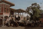 Painting of a caravanserai by Fabius Brest, Musée des beaux-arts de Marseille.
 -
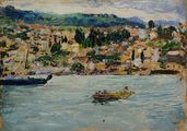
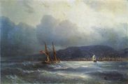 طرابزون من البحر، بريشة إيڤان آيڤازوڤسكي.
 -
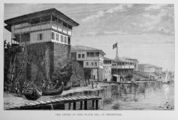 Engraving of the port at Çömlekçi by C. Lapante.
 -
 Trabzon by Jean-Baptiste Henri Durand-Brager.
 -
 Trabzon from the sea by Y.M. Tadevossian.
 -
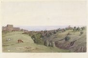 طرابزون من الجنوب، تصوير گودفري ڤين.


.jpg&filetimestamp=20171026160226&)
العصر الحديث


التعداد
| التعداد | 2007 | 2008 | 2009 | 2010 | 2011 | 2012 | 2013 | 2014 | 2015 |
|---|---|---|---|---|---|---|---|---|---|
| الإجمالي | 740,569 | 748,982 | 765,127 | 763,714 | 757,353 | 757,898 | 758,237 | 766,782 | 768,417 |
| الحضر | 396,646 | 390,797 | 408,103 | 415,652 | 757,353 | 757,898 | 758,237 | 766,782 | 768,417 |
| المصدر: TurkStat (المعهد الإحصائي التركي)[21] | |||||||||
الجغرافيا والمناخ


Trabzon Province has a total area of 4،685 متر كيلومربع (1،809 sq mi) وتحدها محافظات ريزه, گيرسون و گوموشخانه. المساحة الإجمالية تنقسم إلى 22.4% هضبة و 77.6% تلال. الجبال الپنطية تقطع محافظة طرابزون.
المناخ
درجة حرارة الماء، مثل باقي الساحل التركي على البحر الأسود، هي دائماً باردة وتتراوح بين 8° س و 20° س طوال العام.
| بيانات المناخ لـ طرابزون | |||||||||||||
|---|---|---|---|---|---|---|---|---|---|---|---|---|---|
| الشهر | ينا | فب | مار | أبر | ماي | يون | يول | أغس | سبت | أكت | نوف | ديس | السنة |
| القصوى القياسية °س (°ف) | 25.9 (78.6) |
28.2 (82.8) |
35.2 (95.4) |
37.6 (99.7) |
37.8 (100.0) |
35.9 (96.6) |
37.0 (98.6) |
34.8 (94.6) |
33.2 (91.8) |
33.8 (92.8) |
30.3 (86.5) |
26.4 (79.5) |
37.8 (100.0) |
| متوسط القصوى اليومية °س (°ف) | 10.9 (51.6) |
11.0 (51.8) |
12.2 (54.0) |
15.6 (60.1) |
19.2 (66.6) |
23.5 (74.3) |
26.2 (79.2) |
26.8 (80.2) |
24.0 (75.2) |
20.1 (68.2) |
16.5 (61.7) |
13.1 (55.6) |
18.3 (64.9) |
| المتوسط اليومي °س (°ف) | 7.5 (45.5) |
7.4 (45.3) |
8.5 (47.3) |
11.9 (53.4) |
16.0 (60.8) |
20.4 (68.7) |
23.2 (73.8) |
23.5 (74.3) |
20.4 (68.7) |
16.5 (61.7) |
12.7 (54.9) |
9.6 (49.3) |
14.8 (58.6) |
| متوسط الدنيا اليومية °س (°ف) | 4.7 (40.5) |
4.4 (39.9) |
5.6 (42.1) |
8.8 (47.8) |
13.0 (55.4) |
17.2 (63.0) |
20.1 (68.2) |
20.6 (69.1) |
17.5 (63.5) |
13.6 (56.5) |
9.8 (49.6) |
6.7 (44.1) |
11.8 (53.3) |
| الصغرى القياسية °س (°ف) | −7.0 (19.4) |
−6.1 (21.0) |
−5.0 (23.0) |
−2.0 (28.4) |
5.2 (41.4) |
9.2 (48.6) |
13.5 (56.3) |
13.8 (56.8) |
8.5 (47.3) |
3.4 (38.1) |
−1.6 (29.1) |
−3.1 (26.4) |
−7.0 (19.4) |
| متوسط تساقط الأمطار mm (inches) | 79.0 (3.11) |
61.0 (2.40) |
58.5 (2.30) |
57.2 (2.25) |
52.7 (2.07) |
50.7 (2.00) |
34.4 (1.35) |
45.5 (1.79) |
78.1 (3.07) |
116.4 (4.58) |
96.1 (3.78) |
80.6 (3.17) |
810.2 (31.87) |
| Average rainy days | 13.2 | 12.5 | 14.0 | 14.4 | 13.6 | 11.4 | 8.2 | 9.3 | 11.7 | 13.4 | 12.6 | 12.8 | 147.1 |
| متوسط الرطوبة النسبية (%) | 69 | 69 | 73 | 75 | 77 | 75 | 73 | 73 | 74 | 73 | 70 | 68 | 72 |
| Mean monthly ساعات سطوع الشمس | 83.7 | 89.6 | 105.4 | 129.0 | 176.7 | 210.0 | 179.8 | 167.4 | 150.0 | 133.3 | 108.0 | 80.6 | 1٬613٫5 |
| المتوسط اليومي ساعات سطوع الشمس | 2.8 | 3.3 | 3.5 | 4.3 | 5.7 | 7.1 | 6.1 | 5.7 | 5.0 | 4.6 | 3.7 | 2.8 | 4.6 |
| Source 1: Turkish State Meteorological Service[22] | |||||||||||||
| Source 2: Weatherbase[23] | |||||||||||||
الاقتصاد
As of 1920, the port at Trabzon, was considered "the most important of the Turkish Black Sea ports", by the British. It traded as far as Tabriz and Mosul. As of 1911, Central Bank of the Republic of Turkey signed an agreement to develop a harbor at the port. When the Russians occupied Trabzon, a mole was built.[24] They built a breakwater and were responsible for creating an extended pier, making loading and unloading easier. In 1920, Trabzon produced linen cloth, silver filagree, tanning and small amounts of cotton, silk and wool. Tobacco and hazelnuts were exported.[25] The tobacco produced in Trabzon was called Trebizond-Platana. It was described as having "large leaves and a bright colour."[26] Trabzon was known for producing poor quality cereals, most which were grown for local use.[27]
Trabzon produced a white green bean, which was sold in Europe. It was, as of 1920, the only vegetable exported out of the province.[26] Poultry farming was also popular in Trabzon. Sericulture was seen in the area before 1914.[28] The area produced copper, silver, zinc, iron and manganese. Copper was kept for local use by coppersmiths. During the Balkan Wars production ceased due to poor exportation and fuel supplies.[29]
السكان


المعالم الرئيسية

.jpg&filetimestamp=20171026112107&)


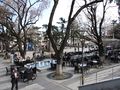
Trabzon has a number of tourist attractions, some of them dating back to the times of the ancient empires that once existed in the region. In the city itself, one can find a hub of shops, stalls and restaurants surrounding the Meydan, a square in the center of the city, which includes a tea garden.
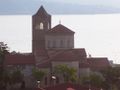
- The Hagia Sophia (تركية: Ayasofya Müzesi), a stunning Byzantine church, is probably the town's most important tourist attraction.
- Trabzon Castle ruins are visible in the town but cannot be visited as they fall in a military zone. The outside wall of the castle now serves as the back wall of a military building.
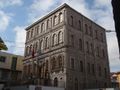
- The "Atatürk Köşkü" is a villa built in 1890 by a local Greek merchant. In 1924 Mustafa Kemal Atatürk stayed in the villa during his visit to Trabzon. He stayed there again in 1937. It houses period rooms and serves as a monument to the memory of the founder and first President of the Republic of Turkey.
- Boztepe Park
- Uzun Sokak is one of the most crowded streets of Trabzon.
- Trabzon Museum is located in the town centre and offers interesting exhibits on the history of the region, including an impressive collection of Byzantine artifacts.
- Trabzon's Bazaar District offers interesting shopping opportunities on ancient narrow streets, continuing from Kunduracılar Street from the Meydan (town square).
- Kostaki Mansion is located to the north of Zeytinlik near Uzun Sokak.
Other sites of the city include: Fatih Mosque (originally the Panagia Khrysokephalos Church), Yeni Cuma Mosque (originally the Agios Eugenios Church), Nakip Mosque (originally the Agios Andreas Church), Hüsnü Köktuğ Mosque (originally the Agios Elevtherios Church), İskender Pasha Mosque, Semerciler Mosque, Çarşı Mosque, Gülbahar Hatun Mosque and Türbe (commissioned by Sultan Selim I), Kalepark (originally Leonkastron).
Within Trabzon Province, the main attractions are the Sümela Monastery (i. e. the Monastery of the Panagia Soumelá) and the Uzungöl lake. The monastery is built on the side of a very steep mountain overlooking the green forests below and is about 50 كيلومتر (31 ميل) south of the city. Uzungöl is famous for the natural beauty of the area and the amazing scenery. Other important sites of interest in the broader region include:
- Kaymaklı Monastery, a formerly Armenian Monastery of the All-Saviour (arm. Ամենափրկիչ Վանք, Amenaprgič Vank),
- Kızlar Monastery of Panagia Theoskepastos (the God-veiled Virgin),
- Kuştul Monastery of Gregorios Peristereotas (gr. Ιερά Μονή του Αγίου Γεωργίου Περιστερεώτα, Ierá Moní tou Agíou Georgíou Peristereóta),
- Vazelon Monastery of Agios Savvas (Maşatlık),
- Cave churches of Agia Anna (Little Ayvasıl), Sotha (St. John), Agios Theodoros, Agios Konstantinos, Agios Christophoros, Agia Kyriakí, Agios Michail and Panagia Tzita churches.[30]
-
-
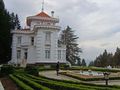 كشك أتاتورك
 -
 Chamber of mechanical engineers.
 -
 طرابزون ميدان.
 -
 Livera village
 -


الثقافة

Folk dancing is still very much in evidence in the Black Sea region. The "Horon" is a famous dance which is indigenous to the city and its surrounding area. It is performed by men, women, the young and elderly alike; in festivities, local weddings and harvest times.[31] While similar to Russian Cossack dances in terms of vividness, the Trabzon folk dance is probably indigenous to the eastern Black Sea region, which has an impressive variety of folk music .
ارتفع قدر المدينة في العالم الناطق بالإنگليزية بعد نشر آخر روايات روز ماكولي، أبراج طرابيزوند (1956)، التي مازالت تُطبع حتى اليوم.[32]
التعليم

Black Sea Technical University in Trabzon hosts students from all over Turkey, especially from the Black Sea and East Anatolian regions, as well as students from the Turkic states in Central Asia.
الرياضة

Trabzon hosted the First Edition of the Black Sea Games in July 2007 and the 2011 European Youth Summer Olympic Festival.
العلاقات الدولية
البلدات التوأم - المدن الشقيقة
طرابزون متوأمة مع:
انظر أيضاً
- امبراطورية طرابيزوند
- World Trade Center Trabzon
- إيالة طرابزون
- ولاية طرابزون
- محافظة طرابزون
- Phrontisterion of Trapezous
- Trabzonspor
- The Towers of Trebizond
- Sümela Monastery
- Lake Uzungöl
- جامعة البحر الأسود التقنية (KTU)
- البحر الأسود
- منطقة البحر الأسود
- كمنجة البحر الأسود
- هورون
- Kolbastı
- أماسيا (أماسيا (القديمة)، عاصمة اليونان الپنطية أثناء القدم الكلاسيكي)
- اليونان الپنطية
- كولخيس
- لاظ (شعب)
- Chepni people
- النمور الأناضولية
ملاحظات ومراجع
- ^ "Area of regions (including lakes), km²". Regional Statistics Database. Turkish Statistical Institute. 2002. Retrieved 2013-03-05.
- ^ "Population of province/district centers and towns/villages by districts - 2012". Address Based Population Registration System (ABPRS) Database. Turkish Statistical Institute. Retrieved 2013-02-27.
- ^ Trabzon (tr) Archived 2011-11-03 at the Wayback Machine
- ^ William Miller (2009). The Latin Orient. Bibliobazaar LLC. pp. 51–54. ISBN 978-1-110-86390-7.
- ^ Campbell, Lawrence Dundas, The Asiatic annual register, or, A View of the history of Hindustan, and of the Politics, Commerce, Literature of Asia, London 1802 Page:3 Google books link : [1]
- ^ Malte-Brun, Conrad, Universal geography: or a description of all parts of the world ..., Volume 2 Google Books link: [2]
- ^ The modern traveller, a popular description geographical, historical, and ... - Google Books
- ^ Die Erdkunde im Verhältniss zur Natur und zur Geschichte des Menschen: oder ... - Carl Ritter - Google Books
- ^ Türkçe Lazca sözlük / Çeviri / Online Çeviri / Lazuri.com
- ^ Özhan Öztürk claims that Ozinis means "flat place" in Laz language and Hurşidabat means "City of the Sun" in Persian/Ottoman language. Pontus: Antik Çağ’dan Günümüze Karadeniz’in Etnik ve Siyasi Tarihi Genesis Yayınları. Ankara, 2011. pp.547-549 ISBN 978-605-54-1017-9
- ^ Phoenix: The Peoples of the Hills: Ancient Ararat and Caucasus by Charles Burney, David Marshall Lang, Phoenix Press; New Ed edition (December 31, 2001)
- ^ Ronald Grigor Suny, The Making of the Georgian Nation: 2nd edition (December 1994), Indiana University Press, ISBN 0-253-20915-3, page 45
- ^ A Star in the East: July 2012
- ^ Miller, Trebizond, p. 12
- ^ Bendall, . "The Mint of Trebizond under Alexius I and the Gabrades", Numismatic Chronicle, Seventh Series, 17 (1977), pp. 126-136
- ^ Britannica 2002, p. 571
- ^ Zorzi, Alvise, Vita di Marco Polo veneziano, Rusconi Editore, 1982
- ^ Prothero, G.W. (1920). Anatolia. London: H.M. Stationery Office.
- ^ أ ب The Armenian People from Ancient to Modern Times, Richard G. Hovannisian, page 27/28, 2004
- ^ http://www.ofhayrat.com/news_print.php?id=4895
- ^ TurkStat (المعهد الإحصائي التركي)
- ^ "Trabzon". Turkish State Meteorological Service. Retrieved 1 September 2016.
- ^ Trabzon, Turkey Travel Weather Averages (Weatherbase)
- ^ Prothero, W.G. (1920). Armenia and Kurdistan. London: H.M. Stationery Office. p. 51.
- ^ Prothero, W.G. (1920). Armenia and Kurdistan. London: H.M. Stationery Office. p. 52.
- ^ أ ب Prothero, W.G. (1920). Armenia and Kurdistan. London: H.M. Stationery Office. p. 61.
- ^ Prothero, W.G. (1920). Armenia and Kurdistan. London: H.M. Stationery Office. p. 60.
- ^ Prothero, W.G. (1920). Armenia and Kurdistan. London: H.M. Stationery Office. p. 64.
- ^ Prothero, W.G. (1920). Armenia and Kurdistan. London: H.M. Stationery Office. p. 73.
- ^ Karalahana.com Archived 2008-06-11 at the Wayback Machine
- ^ People and culture of Trabzon and Black sea region
- ^ Macaulay, Rose: The Towers of Trebizond (Collins, London, 1956)
- ^ "Batumi - Twin Towns & Sister Cities". Batumi City Hall. Archived from the original on 2012-05-04. Retrieved 2013-08-10.
- Princeton Encyclopedia of Classical Sites eds. Richard Stillwell, William L. MacDonald, Marian Holland McAllister: "Trapezus"
- Özhan Öztürk (2005). Karadeniz (Black Sea): Ansiklopedik Sözlük. 2 Cilt. Heyamola Yayıncılık. Istanbul. ISBN 975-6121-00-9
- Bryer, Anthony; David Winfield (March 1985). Byzantine Monuments and Topography of the Pontos (Dumbarton Oaks Studies,20) Two Volume Set. Dumbarton Oaks Pub Service. ISBN 0-88402-122-X.
- CSMonitor.com
- New York Times
وصلات خارجية
- محافظو طرابزون
- تذكرة الحافلة في طرابزون
- Uzungöl in Trabzon
- Trabzon Weather Forecast Information
- بطاقات بريدية تاريخية من طرابزون
- صور من مدينة طرابزون
- تاريخ طرابزون من Karalahana.com
أماكن قريبة من طرابزون | ||||||||||
|---|---|---|---|---|---|---|---|---|---|---|
| ||||||||||
| المقاطعات الحضرية |    | |
|---|---|---|
| المقاطعات الريفية | ||
المناطق | ||
| إيجه | ||
| البحر الأسود | ||
| وسط الأناضول | ||
| شرق الأناضول | ||
| مرمرة | ||
| البحر المتوسط | ||
| جنوب شرق الأناضول | ||
| الشمال |  | |
|---|---|---|
| الجنوب | ||
41°00′N 39°44′E / 41.000°N 39.733°E
| International | |
|---|---|
| National | |
- Pages using gadget WikiMiniAtlas
- Articles with hatnote templates targeting a nonexistent page
- Short description is different from Wikidata
- Pages using photo montage without center alignment
- Articles containing أرمنية-language text
- Pages using Lang-xx templates
- محافظة طرابزون
- مدن تركيا
- منطقة البحر الأسود
- Milesian Pontic colonies
- اليونان الپنطية
- Coordinates on Wikidata
- طرابزون
- مواقع أثرية يونانية قديمة في تركيا
- موانئ البحر الأسود في تركيا
- عواصم أمم سابقة
- أقضية محاظة طرابزون
- امبراطورية طرابيزوند
- مجتمعات صيد في تركيا
- Greek colonies in Pontus
- أماكن ساحلية مأهولة في تركيا
- بلدات ومدن رومانية في تركيا
- موانئ رومانية في تركيا
- أماكن مأهولة تأسست في القرن الثامن ق.م.