زمبوانگا
مدينة زمبوانگا
El Ciudad de Zamboanga Ciudad de Zamboanga | |
|---|---|
.jpg&filetimestamp=20230201024921&)    Clockwise from top: Zamboanga City Hall, Great Santa Cruz Island, Zamboanga City view, Grand Masjid Barbara | |
 Flag  الشعار | |
| الكنية: مدينة آسيا اللاتينية | |
| الشعار: Adelante Zamboanga! | |
 | |
OpenStreetMap  | |
.svg&filetimestamp=20180125123405&) مدينة زمبوانگا | |
| Coordinates: 6°54′N 122°4′E / 6.900°N 122.067°E | |
| البلد | الفلبين |
| المنطقة | شبه جزيرة زمبوانگا (Region IX) |
| Class | 1st Class City; Highly-Urbanized |
| Districts | 1st and 2nd Legislative districts of Zamboanga City |
| Barangays | 98 |
| Official Languages | Zamboangueño (Chavacano) "de facto", الإنگليزية |
| Other Languages/Dialects in Zamboanga City | Hiligaynon, Cebuano, Tausug, Subanon, Samal, Spanish, Tagalog, Chinese |
| Founded | 13th and 14th centuries[1] |
| Established | June 23, 1635 |
| Incorporated (City) | February 26, 1937 |
| Government | |
| • Type | Chartered City of الفلپين |
| • Mayor | Celso L. Lobregat LDP |
| • Vice Mayor | Mannix Dalipe NPC |
| • 1st Dist. Congresswoman | Maria Isabelle G. Climaco LDP |
| • 2nd Dist. Congressman | Erico Basilio A. Fabian LDP |
| Area | |
• Total | 1٬483٫38 كم² (572٫73 ميل²) |
| Elevation | 5 m (16 ft) |
| Population (2007 [3]) | |
• Total | 774٬407 |
| • Density | 522/km2 (1٬353/sq mi) |
| • Demonym | Zamboanganese Zamboangueño Zamboangueña |
| Time zone | UTC+8 (PST) |
| ZIP Code[4] | 7000 |
| Area code | 62 |
| Patron Saint | Nuestra Señora del Pilar |
| Website | www.zamboanga.gov.ph |
مدينة زمبوانگا (Chavacano de Zamboanga/Spanish: Ciudad de Zamboanga) ، هي مدينة تقع في جزيرة مندناو في الفلپين. وتعتبر زمبوانگا سادس مدينة من حيث عدد السكان وثالث أكبر مدينة في الفلپين من حيث المساحة. وهي ضمن مدن عديدة في الفلپين مستقلة عن أي ولاية. وكلمة زمبوانگا ، تطور لكلمة jambangan ، Bahasa Sug وتعني الحديقة.
زامْبُوانْجا مدينة في الفلبين، تقع في الطرف الغربي لجزيرة مينداناو إلى مسافة 885كمً غربي مانيلا. يبلغ عدد سكانها 443,279 نسمة. وتقطنها أغلبية مسلمة. وتُعدّ المدينة الميناء الرئيسيّ والمركز التجاري للمنطقة التي تنتج القنب والمطاط وجوز الهند والأرز والأخشاب. وقد بنى الأسبان قلعة في زامبوانجا عام 1635م، كما استُخدمت المدينة قاعدة للقوات اليابانية إبان الحرب العالمية الثانية (1939- 1945م)، ومع مر الأيام، أصبحت مركزاً للثقافة الإسلامية. وقد كانت زامبوانجا لسنين عديدة الميناء الرئيسي لمينداناو، ولكن مدينة دافاو أخذت منها هذا المركز حاليَّا. يعاني المسلمون في زامبوانجا كثيراً من تحرشات النصارى.
التاريخ
Rajahnate of Sanmalan
The Zamboanga Peninsula was settled in the late 12th or early 13th century by the Subanen people; it was also the homelands of the ancestors of the Yakan, the Balanguingui, and other closely related Sama-Bajau peoples.[5][6]
The 11th-century Chinese Song Dynasty records also mention a polity named "Sanmalan" (三麻蘭) from Mindanao, which has a name similar to Zamboanga and has been tentatively identified with it by some authors (Wang, 2008; Huang, 1980). Sanmalan is said to be led by a Rajah "Chülan". His ambassador "Ali Bakti" and that of Butuan's "Likan-hsieh" is recorded to have visited the Chinese imperial court with gifts and trade goods in AD 1011. However, the correlation between Zamboanga and Sanmalan is based only on their similar-sounding names. Sanmalan is only mentioned in conjunction with Butuan (P'u-tuan) and it is unknown if Sanmalan is indeed Zamboanga. The historian William Henry Scott (1989) also posits the possibility that Sanmalan instead referred to a polity of the Sama-Bajau ("Samal") people.[7][8]
During the 13th century, the Tausūg people began migrating to the Zamboanga Peninsula and the Sulu Archipelago from their homelands in northeastern Mindanao. They became the dominant ethnic group in the archipelago after they were Islamized in the 14th century and established the Sultanate of Sulu in the 15th century. A majority of the Yakan, the Balanguingui, and the Sama-Bajau were also Islamized, though most of the Subanen remained animist (with the exception of the Kolibugan subgroup in southwestern Zamboanga).[5][9][10]
In colonial-era historical records, the city was previously known as Samboangan.[11][12][13][14][15][16][17] Samboangan is a Sinama term for "mooring place" (also spelled sambuangan; and in Subanen, sembwangan), from the root word samboang ("mooring pole").[18] The name was later Hispanicized as Zamboanga.
This is commonly contested by folk etymologies which instead attribute the name to the Indonesian word jambangan (claimed to mean "place of flowers", but actually means "pot" or "bowl"), usually with claims that all ethnic groups in Zamboanga were "Malays". However, this name has never been attested in any historical records prior to the 1960s.[19] The city's nickname "City of Flowers" is derived from such folk etymologies.[20][21]
Spanish rule

Spanish explorers, led by Ferdinand Magellan, arrived in the Philippine archipelago in 1521.[22] Zamboanga was chosen in 1569 as the site of the Spanish settlement and garrison on La Caldera (now part of Barangay Recodo).[23] Spain granted the former Rajahnate of Sanmalan protectorate status against the Sulu Sultanate, its former overlord[24] and the kingdom's name was hispanized into Zamboanga and made a city. Zamboanga City was one of the main strongholds in Mindanao, supporting colonizing efforts in the south of the island and making way for Christian settlements. It also served as a military outpost, protecting the island against foreign invaders and Moro pirates.
In 1599, the Zamboanga fort was closed and transferred to Cebú due to great concerns about attack by the English on that island, which did not occur. After having abandoned the city, the Spaniards as well as some Spanish-American soldiers from Peru[25] and New Spain, joined forces with troops from Pampanga and Visayan soldiers (from Bohol, Cebu and Iloilo) and reached the shore of Zamboanga to bring peace to the island against Moro pirates.[26]
In 1635, Spanish officers and soldiers, along with Visayan laborers, settled in the area and construction began on Fort San José (what is now known as Fort Pilar) to protect the inhabitants of the area from piracy by the Moro.
Zamboanga became the main headquarters of the Spaniards on June 23, 1635, upon approval of King Philip IV of Spain, and the Spanish officially founded the city.[27] Thousands of Spanish troops, headed by a governor general from Spain, took the approval to build the first Zamboanga fortress (now called Fort Pilar) in Zamboanga to forestall enemies in Mindanao like Moro pirates and other foreign invaders.[28] There were also a hundred Spanish troops sent to fortify the nearby Presidio of Iligan.[29] The Zamboanga fortress became the main focus of a number of battles between Moros and Spaniards during Spanish rule in the region from the 16th century to the 18th. Spain was forced to abandon Zamboanga temporarily and withdraw its soldiers to Manila in 1662 after the Chinese under Koxinga threatened to invade the Spanish Philippines.
The Spanish returned to Zamboanga in 1718 and rebuilding of the fort began the following year. The fort would serve as defence for the Christian settlement against Moro pirates and foreign invaders for the coming years. There was deportation of mostly Spanish-American and Spanish vagrants from Manila to Zamboanga which helped advance a colonizing program against the Muslim south, further illustrating how the resistance to Spanish sovereignty in Mindanao and Borneo determined imperial policies on the islands.[30][استشهاد ناقص]
While the region was already dominated by Catholicism, Muslims kept up a protracted struggle into the 18th century against the ruling Spaniards.[31][32] A British naval squadron conducted a raid on Zamboanga in January 1798, but was driven off by the city's defensive fortifications. During 1821, the Uruguayan, Juan Fermín de San Martín, brother of the leader of the Argentinian Revolution, José de San Martín, was commander of the fortress-city of Zamboanga for a year.[33] At 1823, inspired by the Spanish-American Wars of Independence, the Spanish-Americans who had been sent to Zamboanga and Philippines as soldiers, joined in the revolt of Andres Novales, and he fought for sovereignty and became the short lived Emperor of the Philippines. In 1831, the custom house in Zamboanga was established as a port, and it became the main port for direct communication, trading some goods and other services to most of Europe, Southeast Asia and Latin America.[34] The American invaders arrived in the Philippines, headed by General Weyler with thousands of troops to defeat the Spaniards who ruled for over three centuries.
The Spanish government sent more than 80,000 Spanish troops to the Philippines. The Spanish government completely surrendered the islands to the United States in the 1890s.[35]
Establishing its own Republic

The Republic of Zamboanga was established directly on May 28, 1899, after the Zamboangueño revolutionary forces defeated the last Spanish government in Zamboanga. Fort Pilar was turned over to General Vicente Álvarez, who between May and November 1899 was the first president of the República de Zamboanga. This republic continued to exist until 1903, with Isidoro Midel as its second president under a puppet government of the United States; he was succeeded by Mariano Arquiza.[36]
American occupation

Upon the firm establishment of American colonization and dissolution of the Republic in 1903, Zamboanga, as a municipality, was designated as the capital of the Moro Province, a semi-military government consisting of five districts: Zamboanga, Cotabato, Davao, Lanao and Sulu. it established itself the center of commerce, trade, and government of Mindanao Island.[37] During this period, Zamboanga hosted a number of American regional governors, including General John J. Pershing, who was military commander/governor of the Moro Province from 1909 to 1914.
In 1920, Zamboanga City ceased to be capital of the Moro Province[38] when the department was divided into provinces in which the city became under the large province of Zamboanga. This encompasses the present-day Zamboanga Peninsula with the inclusion of the whole province of Basilan.
Commonwealth era and city charter

When the Commonwealth government was established in 1935, calls to convert the municipality of Zamboanga into a city increased. On September 23, 1936, through Assemblyman Juan Alano, the National Assembly of the Philippines passed Commonwealth Act No. 39 making Zamboanga a chartered city consisting of "the present territorial jurisdiction of the municipality of Zamboanga, the municipality of Bolong, the municipal district of Taluksangay, the whole island of Basilan and the adjacent islands, i.e., the municipality of Isabela, the municipal district of Lamitan, and the municipal district of Maluso."[39][40] It was later signed by President Manuel Quezon on October 12, 1936. The charter made Zamboanga City as the largest city in the world in terms of land area. During these times, Zamboanga was the leading commercial and industrial city of Mindanao.
Before World War II, Pettit Barracks, a part of the U.S. Army's 43d Infantry Regiment (PS), was stationed there.
World War II
When the Japanese invaded the Philippines, they were headed by Vice Admiral Rokuzo Sugiyama, accompanied by Rear Admiral Naosaburo Irifune. The Japanese landed at Zamboanga City on March 2, 1942.[41]
The Japanese government in the city was overthrown by American and Filipino forces following a fierce battle on March 10–12, 1945.[36] The rebuilt general headquarters of the Philippine Commonwealth Army and Philippine Constabulary was stationed in Zamboanga City from March 13, 1945, to June 30, 1946, during the military operations in Mindanao and Sulu against the Japanese.[citation needed]
Contemporary history
After World War II
After the war, citizens on the island of Basilan found it difficult to appear in courts, pay their taxes, or seek help from the mayor and other officials. Going from Basilan to the mainland required three or more hours of ferry travel. To fix the problem, Representative Juan Alano filed a bill in Congress to separate Basilan from Zamboanga City. The island of Basilan was proclaimed a separate city through Republic Act No. 288 on July 16, 1948.[42]
On April 7, 1953, by virtue of Republic Act No. 840, the city was classified as first-class city according to its revenue.[43]
On April 29, 1955, a special law changed the landscape of the city government when Republic Act No. 1210[44] amended the City Charter that made elective the position of city mayor and the creation of an elective vice mayor and eight elective city councilors. The vice mayor is the presiding-officer of the City Council. In November 1955, Liberal Party candidate Cesar Climaco with his running-mate, Tomas Ferrer won the first local elections. They were inducted into office on January 1, 1956, as determined by the Revised Election Code.[45]
Martial law years
On September 21, 1972, President Ferdinand Marcos signed Proclamation No. 1081 placing the Philippines under martial law. Zamboanga City's local government came under presidential control for the first time since 1955. Marcos extended Enriquez's term when his tenure was about to end in 1975.
President Marcos reorganized the local government on November 14, 1975, and the city council was replaced by a Sangguniang Panlungsod with the mayor as its new presiding officer and its members included the vice mayor, the chairman of the Katipunan ng mga Kabataang Barangay, the president of the Association of Barangay Captains, and sectoral representatives of agriculture, business and labor.[46]
When Mayor Enriquez resigned and bid for the newly created Interim Batasang Pambansa in 1978, Vice Mayor Jose Vicente Atilano II was appointed by President Marcos to replace him.
Climaco's return (1980–1984)
In 1980, Cesar Climaco staged his political comeback when he was elected again to the mayoral post under his new party, the Concerned Citizen's Aggregation. He had gone into exile to the United States in protest against Marcos' declaration of martial law.[47]
In the 1984 Philippine parliamentary election, Climaco was elected a member of the Regular Batasang Pambansa. However, he declined to assume his seat until he had completed his six-year term as mayor in his consistent protest against Marcos. Climaco's protest against the dictator earned Zamboanga City the distinction of 'the beacon of democracy in Mindanao'.
21st century
On November 19, 2001, the Cabatangan Government Complex in Barangay Cabatangan, the seat of the Autonomous Region in Muslim Mindanao, was raided by former MNLF fighters in protest of Misuari's ouster as Governor of the autonomous region in which they took residents hostage. The complex also houses the different regional government offices such as the Commission on Audit, Population Commission, Civil Service Commission, Area Vocational Rehabilitation Center, DECS Training Center and the Zamboanga Arturo Eustaquio College Department of Criminology. An air strike by the military began on November 27 in which the hostages were later released after the government agreed to escort the rebels to a safe zone in Panubigan where they were allowed to go free.[48]
In 2013, Maria Isabelle Climaco Salazar, niece of former Mayor Cesar Climaco, was elected the second woman mayor of the city.[49]
Zamboanga City crisis
On September 9, 2013, a faction of the Moro National Liberation Front (MNLF) under the leadership of Nur Misuari seized hostages in Zamboanga City and attempted to raise the flag of the self-proclaimed Bangsamoro Republik, a state which declared its independence earlier in August, in Talipao, Sulu. This armed incursion has been met by the Armed Forces of the Philippines, which seeks to free the hostages and expel the MNLF from Zamboanga City. The standoff degenerated into urban warfare, and brought parts of the city under standstill for days.[50]
Mayor Climaco-Salazar and her administration are relocating the internal displaced persons (IDPs) affected by the crisis to transitory sites and later, permanent housings in various places around Zamboanga City.[51] Her rehabilitation plan, "Zamboanga City Roadmap to Recovery and Rehabilitation (Z3R)", envisions building back a better Zamboanga City and rehabilitating the areas affected by the crisis.[52]
الجغرافيا
Geology
The southwest and eastern sides of Zamboanga City are bounded by irregular coastlines with generally rocky terrain and occasional stretches of sandy or gravelly beaches. The coastal profile usually descends abruptly towards the sea. Where rivers enter the sea, bays have formed, and the surrounding area has filled up with alluvial soils, producing small to large coastal plains.[citation needed]
Topography
The overall topography of the city could be described as rolling to very steep. There are some flat lands, mostly narrow strips along the east coast. The urban center is mostly flat with a gentle slope to the interior, ranging from 0% to 3%. A portion, about 38,000 hectares, has slopes ranging from 18% to 30%. Another 26,000 hectares has slopes of less than 3%, while about 37% of the area (52,000 hectares) has slopes ranging from 30% to more than 50%. The highest registered elevation is 1,200 metres.[53]
The territorial jurisdiction of the city includes the islands of big and small Santa Cruz, Tictabon, Sacol, Manalipa, Tumalutap, Vitali, as well as other numerous islands. The total land area of the city is recorded to be 142,067.95 hectares or 1,420.6795 square kilometers and with contested land area of 3,259.07 hectares between the boundary of Limpapa and Zamboanga del Norte, consolidated of the total land area 145,327.02 hectares or 1,453.2702 Km2 according to the latest cadastral survey of DENR IX year 2015.[54] This does not include the area of about 25 other islands within the territorial jurisdiction of the city – which have an aggregate area of 6,248.5 hectares as verified by the Office of the City Engineer. Putting these all together, the city's new total land area would come to 151,575.52 hectares or 1,515.75. Km2.
المناخ
| متوسطات الطقس لمدينة زمبوانگا , الفلپين | |||||||||||||
|---|---|---|---|---|---|---|---|---|---|---|---|---|---|
| شهر | يناير | فبراير | مارس | أبريل | مايو | يونيو | يوليو | أغسطس | سبتمبر | اكتوبر | نوفمبر | ديسمبر | السنة |
| العظمى القياسية °F (°C) | 102 (39) | 108 (42) | 99 (37) | 106 (41) | 99 (37) | 108 (42) | 104 (40) | 100 (38) | 106 (41) | 99 (37) | 99 (37) | 100 (38) | 108 (42) |
| متوسط العظمى °ف (°م) | 82 (28) | 81 (27) | 81 (27) | 82 (28) | 82 (28) | 82 (28) | 82 (28) | 81 (27) | 82 (28) | 81 (27) | 81 (27) | 81 (27) | 81 (27) |
| متوسط الصغرى °ف (°م) | 75 (24) | 73 (23) | 73 (23) | 75 (24) | 75 (24) | 77 (25) | 75 (24) | 75 (24) | 75 (24) | 75 (24) | 75 (24) | 73 (23) | 73 (23) |
| الصغرى القياسية °ف (°C) | 63 (17) | 63 (17) | 68 (20) | 55 (13) | 70 (21) | 68 (20) | 63 (17) | 70 (21) | 59 (15) | 55 (13) | 70 (21) | 68 (20) | 55 (13) |
| هطول الأمطار بوصة (cm) | 1.6 (4) | 2 (5) | 1.6 (4) | 2 (5) | 3.5 (9) | 4.7 (12) | 5.1 (13) | 4.7 (12) | 5.1 (13) | 6.3 (16) | 4.3 (11) | 3.1 (8) | 46٫9 (119) |
| المصدر: Weatherbase[55] Jan 2009 | |||||||||||||
Zamboanga City features a tropical wet and dry climate under the Köppen climate classification (Aw).
الجزر المركبة
الديموغرافيا
| السنة | تعداد | ±% |
|---|---|---|
| 1898 | 19٬844 | — |
| 1903 | 20٬692 | +4.3% |
| 1918 | 42٬007 | +103.0% |
| 1939 | 73٬894 | +75.9% |
| 1948 | 103٬317 | +39.8% |
| 1960 | 131٬489 | +27.3% |
| 1970 | 199٬901 | +52.0% |
| 1975 | 265٬023 | +32.6% |
| 1980 | 343٬722 | +29.7% |
| 1990 | 442٬345 | +28.7% |
| 1995 | 511٬139 | +15.6% |
| 2000 | 601٬794 | +17.7% |
| 2007 | 774٬407 | +28.7% |
| Source: [56] | ||
السكان
الديانة
اللغات
الحكومة

المواصلات
النقل البري ومشروعات الحكومة
النقل البحري الدولي
انظر أيضا ميناء زمبوانگا
موجز عن النقل البحري في زمبوانگا
| ||||||||||
Year |
إجمالي المسافرين |
Disembarking | Embarking | |||||||
| 1999 | 4,577,404 | 2,381,041 | 2,196,363 | |||||||
| 2000 | 4,924,174 | 2,575,729 | 2,348,445 | |||||||
| 2001 | 5,244,387 | 2,643,093 | 2,601,294 | |||||||
| 2002 | 5,570,493 | 2,834,766 | 2,735,727 | |||||||
| 2003 | 5,531,748 | 2,857,923 | 2,673,825 | |||||||
| 2004 | 5,665,392 | 2,962,956 | 2,702,436 | |||||||
| 2005 | 4,374,473 | 2,218,717 | 2,155,756 | |||||||
| 2006 | 3,208,531 | 1,604,273 | 1,604,258 | |||||||
| 2007 | 3,221,326 | 1,603,983 | 1,617,343 | |||||||
المطار الدولي

الحافلات
الاقتصاد والصناعة

البنية التحتية
البنوك
هيئة المنطقة الاقتصادية الخاصة لمدينة زمبوانگا

صناعة الأعشاب البحرية
صناعة التعليب

مراكز التسوق والمجمعات التجارية

التعليم
المؤسسات التعليمية في مدينة زمبوانگا
- AMA Computer College- Zamboanga Campus
- AMA Computer Learning Center (ACLC)
- Asian Institute of Health Care (AIM)
- Ateneo de Zamboanga University
- Ayala Technical Vocational School
- Brent Hospital & Colleges Inc.
- Ciudad De Zamboanga Nurse Care Review Center, Inc.
- Colegio de Moderno Technico Y Informatico (CMTI)
- Computer Technologies Instittute of Zamboanga City (COMTECH)
- Delcom College
- Delfin Computer Learning Center Inc.
- Ebenezer Bible College & Seminary
- EWORLD Career Center Corp.
- HMIJ Institute of Technology (Formerly HMIJ Philippine Islamic College)
- Immaculate Conception Archdiocesan School
- J-Jireh College School
- Mindanao Electronics Institute (MEIN College)
- Nuevo Zamboanga College
- Pastor Bonus Seminary
- Philippine Public Safety College
- Pilar College
- Regional Science High School for Region IX
- Southern City Colleges (SCC)
- St. Augustine School of Nursing-Zamboanga Branch
- STI College- Zamboanga
- Sungold Technologies Inc.
- Universal College of Southeast Asian and Pacific Inc.
- Universidad de Zamboanga
- Vitali Technical Vocational School
- Western Mindanao Cooperative College (WMCC)
- Western Mindanao State University
- Zamboanga Aeronautics Technology, Inc.
- Zamboanga City Academy and Training Institute, Inc.
- Zamboanga City Medical Center School of Nursing
- Zamboanga City State Polytechnic College
- Zamboanga College of Engineering & Technical Cooperative School
- Zamboanga Institute of Aviation & Technology
- Zamboanga Maritime Training Institute
- Zamboanga Medical School
- Zamboanga School of Arts & Trade
- Zamboanga State College of Marine Sciences and Technology (ZSCMST)
- Zamboanga Polytechnic School
الكليات والجامعات

العلاقات الخارجية
مدن شقيقة
| ||||||||||
السنة |
البلد |
المدينة
| ||||||||
2005 |
||||||||||
2006 |
||||||||||
2006 |
||||||||||
2008 |
||||||||||
2009 |
||||||||||
قيد |
||||||||||
مدن صديقة
| ||||||||||
السنة |
البلد |
المدينة
| ||||||||
المستشفيات ومراكز الرعاية الصحية
الحدائق والمعالم

الثقافة
الفنون الثقافية والموسيقى

الإعلام
انظر أيضا إعلام مدينة زمبوانگا
المطبخ

الترفيه والابداع

السياحة

مهرجانات وأحداث
- Dia de Zamboanga
- Holy Week
March/April (movable)
- Flores de Mayo
May 1 - 31
- Santacruzan
Last day of Flores de Mayo
- La Hermosa Festival

- Pascua na Cuidad

- Fonda de Barangay
معرض الصور
-
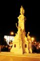 Rizal Monument at night
 -
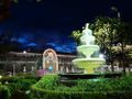 Port Pilar Fountain
 -
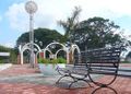 Paseo del Mar Bench
 -
 ZC National Museum
 -
 National Museum Courtyard ZC
 -
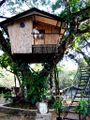 ZC Tree House
 -
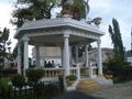 John Pershing Kiosk 1915
 -
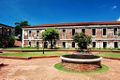
 Old Normal School (WMSU) Build during the American Era


انظر أيضا
- Wikitravel Entry on Zamboanga City, Philippines
- إعلام مدينة زمبوانگا
- معرض صور مدن آسيا اللاتينية
- Zamboanga City Special Economic Zone and Freeport Authority
- Viernes Clan Informative
- Zamboanga City Gallery
المصادر
- ^ http://www.zamboanga.com/history/history_zamboanga.htm
- ^ http://www.wunderground.com/global/stations/98836.html
- ^ http://zamboanga.com/Business/population_of_zamboanga_city.htm
- ^ http://zip-codes.philsite.net/zamboanga.htm
- ^ أ ب Pallasen, A. Kemp (1985). Culture Contact and Language Convergence (PDF). LSP Special Monograph Issue 24. Manila: Linguistic Society of the Philippines. Archived from the original (PDF) on May 11, 2015.
- ^ Hoogervorst, Tom Gunnar (2012). "Ethnicity and Aquatic Lifestyles: Exploring Southeast Asia's Past and Present Seascapes" (PDF). Water History. 4 (3): 245–265. doi:10.1007/s12685-012-0060-0. S2CID 53668253.
- ^ Scott, William Henry (1983). "Filipinos in China Before 1500". Asian Studies. 21: 4.
- ^ Wang, Zhenping (2008). "Reading Song-Ming Records on the Pre-colonial History of the Philippines" (PDF). Higashi Ajia bunka kōshō kenkyū 東アジア文化交渉研究. 1: 249–260. hdl:10112/3180.
- ^ Iledo, Josefina B. (n.d.). "Zamboanga's Historic Past and the Rich Cultural Heritage". zamboanga.net. Archived from the original on September 27, 2010. Retrieved April 18, 2010.
- ^ Jubilado, Rodney C. (2010). "On Cultural Fluidity: The Sama-Bajau of the Sulu-Sulawesi Seas". Kunapipi. 32 (1): 89–101.
- ^ Combes, Francisco (1667). Historia de las islas de Mindanao, Iolo y sus adyacentes: Progresos de la religion y armas catolicas (in الإسبانية). Madrid: Pablo del Val.
- ^ Challenger Expedition 1872–1876 (1895). Report on the Scientific Results of the Voyage of H.M.S. Challenger During the Years 1873–76 Under the Command of Captain George S. Nares ... and the Late Captain Frank Tourle Thomson, R.N. H.M. Stationery Office. pp. 823–828.
{{cite book}}: CS1 maint: numeric names: authors list (link) - ^ Wright, George Newenham (1837). "Samboangan". A New and Comprehensive Gazetteer. Vol. 4. London: Thomas Kelly. p. 459.
- ^ Prévost, Antoine-François (1757). Histoire générale des voyages ou Nouvelle collection de toutes les relations de voyages par mer et par terre, qui ont été publiées jusqu'à présent dans les differentes langues de toutes les nations connues (in الفرنسية). Vol. 15. La Haye: Pierre de Hondt. p. 37.
- ^ Roubaud, Pierre Joseph André (1770). Histoire générale de l'Asie, de l'Afrique et de l'Amérique (in الفرنسية). Vol. 4. Paris: Des Ventes de la Doué. p. 499–500.
Samboangan.
- ^ Meares, John (1791). Des Kapitians John Meares und des Kapitains William Douglas Reisen nach der Nordwest-Küste von Amerika, in den Jahren 1786 bis 1789 (in الألمانية). Berlin: Voß. p. 240.
- ^ Pickering, Charles (1848). "The Races of Man and their Geographical Distribution" (PDF). United States Exploring Expedition: During the Years 1838, 1839, 1840, 1841, 1842: Under the Command of Charles Wilkes, U. S. N. Vol. 9: The Races of Man: And Their Geographical Distribution. Philadelphia: Printed by C. Sherman. p. 125.
- ^ Rodney C. Jubilado; Hanafi Hussin; Maria Khristina Manueli (2011). "The Sama-Bajaus of Sulu-Sulawesi Seas: Perspectives from Linguistics and Culture". JATI – Journal of Southeast Asian Studies. 15 (1): 83–95.
- ^ Enriquez, A. R. (September 5, 2011). "Jambangan: the "Garden of Flowers" never was!". Antoniofermin's Name. Retrieved September 13, 2016.
- ^ Arnaldo, Maria Stella (November 13, 2017). "DOT allots P2M to Zamboanga City for Reblooming Project". BusinessMirror. Retrieved November 1, 2021.
Zamboanga derives its name from "Jambangan," a Malay word that means "City of Flowers."
- ^ Wee, Darwin Wally (October 3, 2017). "DOT to Launch Beautification Drive in Zambo". Philippine News Agency (in الإنجليزية). Retrieved November 1, 2021.
- ^ "Pre-Historic to Pre-Colonial Philippines". Philippines-Archipelago. Archived from the original on June 28, 2010. Retrieved April 18, 2010.
- ^ "History of Zamboanga – Circa 1500s". Zamboanga.com. Retrieved April 18, 2010.
- ^ Caceres, Michael Vincent P. (n.d.), Origination and Formation of Sulu Sultanate during the 14th Century Southeast Asia, https://www.academia.edu/6450603, retrieved on June 6, 2022
- ^ "SECOND BOOK OF THE SECOND PART OF THE CONQUESTS OF THE FILIPINAS ISLANDS, AND CHRONICLE OF THE RELIGIOUS OF OUR FATHER, ST. AUGUSTINE" (Zamboanga City History) "He (Governor Don Sebastían Hurtado de Corcuera) brought a great reënforcements of soldiers, many of them from Perú, as he made his voyage to Acapulco from that kingdom."
- ^ Blair, Emma Helen; Robertson, James Alexander (1905). The Philippine Islands, 1493–1898. Vol. 25. Cleveland, Ohio: Arthur H. Clark Company. pp. 150–177.
- ^ "Zamboanga City History: 371 Years: 1635–2006". Zamboanga.com. Archived from the original on September 25, 2009. Retrieved April 18, 2010.
- ^ Foreman, John (1906). The Philippine Islands: A Political, Geographical, Ethnographical, Social and Commercial History of the Philippine Archipelago: Embracing the Whole Period of Spanish Rule: With an Account of the Succeeding American Insular Government (3rd revised and enlarged ed.). London: T. Fisher Unwin – via Project Gutenberg.
- ^ San Agustín, Conquistas, lib. 2 cap 37: 545
- ^ CSIC riel 311 leg.1 (1758).
- ^ "History of Zamboanga – Circa 1600s". Zamboanga.com. Archived from the original on January 10, 2010. Retrieved April 18, 2010.
- ^ "History of Zamboanga – Circa 1700s". Zamboanga.com. Archived from the original on September 27, 2011. Retrieved April 18, 2010.
- ^ In Spanish: Peiró, Claudia (January 15, 2015). "El hermano desconocido de San Martín que luchó y murió en Filipinas". Infobae (in الإسبانية). Retrieved June 7, 2022.
- ^ Foreman, John (1906). The Philippine Islands: A Political, Geographical, Ethnographical, Social and Commercial History of the Philippine Archipelago: Embracing the Whole Period of Spanish Rule: With an Account of the Succeeding American Insular Government (3rd revised and enlarged ed.). London: T. Fisher Unwin – via Project Gutenberg.
- ^ Foreman, John (1906). The Philippine Islands: A Political, Geographical, Ethnographical, Social and Commercial History of the Philippine Archipelago: Embracing the Whole Period of Spanish Rule: With an Account of the Succeeding American Insular Government (3rd revised and enlarged ed.). London: T. Fisher Unwin – via Project Gutenberg.
- ^ أ ب "Republic of Zamboanga: A Recognition of History". Zamboanga.com. July 18, 2009. Archived from the original on December 1, 2010. Retrieved April 18, 2010.
- ^ "History of Zamboanga – Circa 1900s". Zamboanga.com. Archived from the original on February 10, 2010. Retrieved April 18, 2010.
- ^ "Provincial Capitol: Zamboanga del Sur". Legendharry. October 19, 2013. Archived from the original on October 19, 2017. Retrieved May 4, 2018.
{{cite web}}: CS1 maint: unfit URL (link) - ^ خطأ استشهاد: وسم
<ref>غير صحيح؛ لا نص تم توفيره للمراجع المسماةzamboanga.com charter - ^ خطأ استشهاد: وسم
<ref>غير صحيح؛ لا نص تم توفيره للمراجع المسماةCommonwealth Act No. 39 - ^ "Japanese Landings at Zamboanga, 2 March 1942". CMH Online. Archived from the original on April 13, 2010. Retrieved April 18, 2010.
- ^ Republic Act No. 288, http://elibrary.judiciary.gov.ph/thebookshelf/showdocs/2/10838
- ^ Republic Act No. 840, https://elibrary.judiciary.gov.ph/thebookshelf/showdocs/2/25860
- ^ Republic Act No. 1210, http://elibrary.judiciary.gov.ph/thebookshelf/showdocs/2/10744
- ^ Republic Act No. 180, http://elibrary.judiciary.gov.ph/thebookshelf/showdocs/2/10407
- ^ Presidential Decree No. 826, November 14, 1975, http://elibrary.judiciary.gov.ph/thebookshelf/showdocs/26/17329
- ^ "City Socio Economic Profile: Volume II, Part I: Situation Analysis". zamboanga.net. Archived from the original on May 8, 2018. Retrieved May 8, 2018.
- ^ Diesto, Jovian (January 18, 2006). "City Has No Plans yet for Cabatangan". ZamboTimes. Archived from the original on September 21, 2013. Retrieved September 20, 2013.
- ^ Valente, Jordan (2014), Women's Representation in Local Politics: Evidence from the Philippines, MPRA Paper No. 57903, doi:, https://mpra.ub.uni-muenchen.de/57903/1/MPRA_paper_57903.pdf
- ^ Reyes, Jewel (September 9, 2013). "MNLF Wants Flag Hoisted in Zamboanga City Hall". ABS-CBN News. Retrieved June 7, 2022.
- ^ Pareño, Roel (May 14, 2014). "Zamboanga City Relocates Siege Evacuees from Cramped Camp". Philstar Global. Retrieved June 6, 2022.
- ^ "Updated Z3R Plan Presented". Daily Zamboanga Times. January 27, 2014. Archived from the original on April 2, 2015. Retrieved March 9, 2015.
- ^ "City Socio Economic Profile: Chapter IV: The Physical Environment". zamboanga.net. Archived from the original on July 24, 2011. Retrieved March 8, 2011.
- ^ National Economic and Development Authority (n.d.). Zamboanga Peninsula: Regional Spatial Development Framework, 2016–2045. Pagadian City: National Economic and Development Authority. DENR Cadastral Survey 2015, Map 2, p. 11. Retrieved November 6, 2021 – via Google Drive.
- ^ {{cite web |url =http://www.weatherbase.com/weather/weather.php3?s=63889&refer=&units=metric = |title =Weatherbase: Historical Weather for Zamboanga City, Philippines | publisher=Weatherbase | year=2009 | accessdate=2009-01-21}}
- ^ http://209.85.175.132/search?q=cache:1kOnEAiuCeQJ:www3.pids.gov.ph/ris/dps/pidsdps0450.pdf+Population+zamboanga+city+2000.&hl=en&ct=clnk&cd=7&gl=ph
6°54′N 122°4′E / 6.900°N 122.067°E{{#coordinates:}}: لا يمكن أن يكون هناك أكثر من وسم أساسي واحد لكل صفحة
- Pages using gadget WikiMiniAtlas
- CS1 uses اليابانية-language script (ja)
- CS1 الإسبانية-language sources (es)
- CS1 maint: numeric names: authors list
- CS1 الفرنسية-language sources (fr)
- CS1 الألمانية-language sources (de)
- CS1 maint: unfit URL
- صفحات ذات وسوم إحداثيات غير صحيحة
- Short description is different from Wikidata
- Coordinates on Wikidata
- Pages using infobox settlement with unknown parameters
- Pages using infobox settlement with potentially too many maps
- Articles with hatnote templates targeting a nonexistent page
- Articles with incomplete citations from June 2022
- All articles with incomplete citations
- Articles with unsourced statements from July 2016
- Articles with unsourced statements from December 2015
- Pages using center with no arguments
- مدينة زمبوانگا
- مدن الفلبين
- صفحات مع الخرائط