خط العرض 50° شمالاً

خط العرض 50 شمالًا (إنگليزية: 50th parallel north) هي دائرة عرض بزاوية 50 درجة شمال خط الاستواء. تمر دائرة العرض 50° شمالاً عبر أفريقيا، المحيط الهندي، جنوب آسيا، جنوب شرق آسيا، المحيط الهادي، أمريكا الوسطى، امريكا الجنوبية والمحيط الأطلسي..

Line across the Earth
50°
خط العرض 50 شمال

عند خط العرض هذا، تكون الشمس مرئية لمدة 16 ساعة و 22 دقيقة أثناء الانقلاب الصيفي، و8 ساعات و 4 دقائق أثناء الانقلاب الشتوي.[1]

. . . . . . . . . . . . . . . . . . . . . . . . . . . . . . . . . . . . . . . . . . . . . . . . . . . . . . . . . . . . . . . . . . . . . . . . . . . . . . . . . . . . . . . . . . . . . . . . . . . . . . . . . . . . . . . . . . . . . . . . . . . . . . . . . . . . . . . . . . . . . . . . . . . . . . . . . . . . . . . . . . . . . . . .

حول العالم

ملف:Geodesia Stele.jpg
A sculpture at the Rhein-Main Regional Park (de) in Germany showing Mainz and other cities around the world that lie along the 50th parallel north (distances not to scale)
 
50th latitude mark in central Mainz, Germany
 
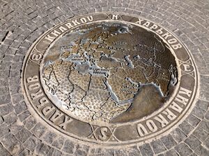
A plaque marking the 50th parallel north in Kharkiv, Ukraine
 
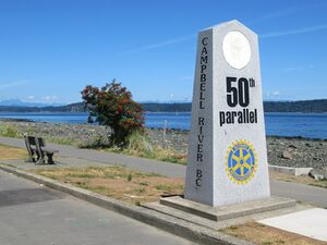
50th parallel marker next to the Old Island Highway in Campbell River, British Columbia, Canada

بدءاً من خط الزوال الرئيسي، في الاتجاه الشرقي، يمر خط العرض 50° شمالاً عبر:

الإحداثيات البلد أو الإقليم أو البحر ملاحظات
50°0′N 0°0′E / 50.000°N 0.000°E / 50.000; 0.000 (Prime Meridian) English Channel
50°0′N 1°15′E / 50.000°N 1.250°E / 50.000; 1.250 (France)   فرنسا Upper Normandy — for about 20 km
Picardy — passing just north of Amiens
Nord-Pas-de-Calais — for about 13 km
50°0′N 4°10′E / 50.000°N 4.167°E / 50.000; 4.167 (Belgium)   بلجيكا Wallonia
50°0′N 4°40′E / 50.000°N 4.667°E / 50.000; 4.667 (France)   فرنسا Champagne-Ardenne — for about 10 km
50°0′N 4°49′E / 50.000°N 4.817°E / 50.000; 4.817 (Belgium)   بلجيكا Wallonia
50°0′N 5°49′E / 50.000°N 5.817°E / 50.000; 5.817 (Luxembourg)   لوكسمبورگ Diekirch District
50°0′N 6°9′E / 50.000°N 6.150°E / 50.000; 6.150 (Germany)   ألمانيا Rhineland-Palatinate
Hesse
Rhineland-Palatinate — passing through Mainz city centre
Hesse — passing just south of Frankfurt, crossing a runway of FRA international airport and passing just south of DCF77 time signal transmitter
Bavaria — passing just north of Bayreuth
50°0′N 12°26′E / 50.000°N 12.433°E / 50.000; 12.433 (Czech Republic)   التشيك Passing through southern parts of Prague
50°0′N 17°49′E / 50.000°N 17.817°E / 50.000; 17.817 (Poland)   بولندا For about 11 km
50°0′N 17°58′E / 50.000°N 17.967°E / 50.000; 17.967 (Czech Republic)   التشيك For about 10 km
50°0′N 18°7′E / 50.000°N 18.117°E / 50.000; 18.117 (Poland)   بولندا Passing through southern districts of Kraków (on the 20th meridian east)
Passing through southern districts of Tarnów (on the 21st meridian east)
Passing through southern districts of Rzeszów (on the 22nd meridian east)
50°0′N 23°10′E / 50.000°N 23.167°E / 50.000; 23.167 (Ukraine)   أوكرانيا Lviv Oblast — passing just north of Lviv
Ternopil Oblast — passing through Pochaiv
Khmelnytskyi Oblast
Zhytomyr Oblast — passing through Andrushivka
Kyiv Oblast
Cherkasy Oblast
Poltava Oblast — passing through Lubny
Kharkiv Oblast — passing through Kharkiv city centre
50°0′N 37°57′E / 50.000°N 37.950°E / 50.000; 37.950 (Russia)   روسيا Belgorod Oblast — for about 18 km
50°0′N 38°12′E / 50.000°N 38.200°E / 50.000; 38.200 (Ukraine)   أوكرانيا Luhansk Oblast — for about 12 km
50°0′N 38°22′E / 50.000°N 38.367°E / 50.000; 38.367 (Russia)   روسيا Belgorod Oblast
Voronezh Oblast — passing just north of Boguchar
Rostov Oblast
Volgograd Oblast — passing just south of Kamyshin
50°0′N 47°15′E / 50.000°N 47.250°E / 50.000; 47.250 (Kazakhstan)   كازاخستان West Kazakhstan Province
50°0′N 48°8′E / 50.000°N 48.133°E / 50.000; 48.133 (Russia)   روسيا Saratov Oblast
50°0′N 48°51′E / 50.000°N 48.850°E / 50.000; 48.850 (Kazakhstan)   كازاخستان West Kazakhstan Province
Aktobe Province
Kostanay Province
Karagandy Province — passing just north of Karaganda
East Kazakhstan Province — passing just north of Oskemen
50°0′N 85°2′E / 50.000°N 85.033°E / 50.000; 85.033 (Russia)   روسيا Altai Republic
Tuva
50°0′N 89°58′E / 50.000°N 89.967°E / 50.000; 89.967 (Mongolia)   منغوليا Passing through the southern tip of Uvs Lake
50°0′N 95°1′E / 50.000°N 95.017°E / 50.000; 95.017 (Russia)   روسيا Tuva
50°0′N 95°45′E / 50.000°N 95.750°E / 50.000; 95.750 (Mongolia)   منغوليا For about 11 km
50°0′N 95°55′E / 50.000°N 95.917°E / 50.000; 95.917 (Russia)   روسيا Tuva — for about 7 km
50°0′N 96°2′E / 50.000°N 96.033°E / 50.000; 96.033 (Mongolia)   منغوليا For about 11 km
50°0′N 96°10′E / 50.000°N 96.167°E / 50.000; 96.167 (Russia)   روسيا Tuva
50°0′N 97°55′E / 50.000°N 97.917°E / 50.000; 97.917 (Mongolia)   منغوليا
50°0′N 107°13′E / 50.000°N 107.217°E / 50.000; 107.217 (Russia)   روسيا Buryatia — for about 5 km
50°0′N 107°18′E / 50.000°N 107.300°E / 50.000; 107.300 (Mongolia)   منغوليا For about 3 km
50°0′N 107°20′E / 50.000°N 107.333°E / 50.000; 107.333 (Russia)   روسيا Buryatia
Zabaykalsky Krai
50°0′N 113°34′E / 50.000°N 113.567°E / 50.000; 113.567 (Mongolia)   منغوليا
50°0′N 115°12′E / 50.000°N 115.200°E / 50.000; 115.200 (Russia)   روسيا Zabaykalsky Krai
50°0′N 116°1′E / 50.000°N 116.017°E / 50.000; 116.017 (Mongolia)   منغوليا
50°0′N 116°20′E / 50.000°N 116.333°E / 50.000; 116.333 (Russia)   روسيا Zabaykalsky Krai
50°0′N 119°6′E / 50.000°N 119.100°E / 50.000; 119.100 (China)   الصين Inner Mongolia
Heilongjiang
50°0′N 127°29′E / 50.000°N 127.483°E / 50.000; 127.483 (Russia)   روسيا Amur Oblast
Khabarovsk Krai
50°0′N 140°30′E / 50.000°N 140.500°E / 50.000; 140.500 (Strait of Tartary) Strait of Tartary
50°0′N 142°9′E / 50.000°N 142.150°E / 50.000; 142.150 (Russia)   روسيا Sakhalin Oblast — island of Sakhalin
50°0′N 143°59′E / 50.000°N 143.983°E / 50.000; 143.983 (Sea of Okhotsk) Sea of Okhotsk
50°0′N 155°23′E / 50.000°N 155.383°E / 50.000; 155.383 (Russia)   روسيا Sakhalin Oblast — island of Paramushir
50°0′N 155°24′E / 50.000°N 155.400°E / 50.000; 155.400 (Pacific Ocean) Pacific Ocean
50°0′N 127°19′W / 50.000°N 127.317°W / 50.000; -127.317 (Canada)   كندا British ColumbiaVancouver Island (passing through the town of Campbell River) and mainland, also through the Okanagan Valley immediately north of Kelowna.
Alberta — passing through the city of Medicine Hat
Saskatchewan it passes a few km south of the cities of Swift Current, Moose Jaw and the capital, Regina
Manitoba — passing just north of Winnipeg
Ontario — passing through Lake Nipigon
Quebec - passing through the town of Port-Cartier
50°0′N 66°54′W / 50.000°N 66.900°W / 50.000; -66.900 (Gulf of Saint Lawrence) Gulf of Saint Lawrence Passing just north of Anticosti Island, Quebec,   كندا
50°0′N 57°45′W / 50.000°N 57.750°W / 50.000; -57.750 (Canada)   كندا Newfoundland and Labrador — island of Newfoundland
50°0′N 56°46′W / 50.000°N 56.767°W / 50.000; -56.767 (White Bay) White Bay
50°0′N 56°21′W / 50.000°N 56.350°W / 50.000; -56.350 (Canada)   كندا Newfoundland and Labrador — island of Newfoundland
50°0′N 55°52′W / 50.000°N 55.867°W / 50.000; -55.867 (Atlantic Ocean) Atlantic Ocean Confusion Bay
50°0′N 55°33′W / 50.000°N 55.550°W / 50.000; -55.550 (Canada)   كندا Newfoundland and Labrador — island of Newfoundland
50°0′N 55°31′W / 50.000°N 55.517°W / 50.000; -55.517 (Atlantic Ocean) Atlantic Ocean Passing just north of the Isles of Scilly, England,   المملكة المتحدة
50°0′N 5°16′W / 50.000°N 5.267°W / 50.000; -5.267 (United Kingdom)   المملكة المتحدة EnglandLizard Peninsula, Cornwall, for about 7 km
50°0′N 5°10′W / 50.000°N 5.167°W / 50.000; -5.167 (English Channel) English Channel


جزيرة سخالين

 
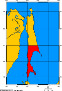
Sakhalin island between 1905 and 1945. The area south of the 50th parallel line was under Japanese control

جزيرة سخالين بين عامي 1905 و 1945. كانت المنطقة الواقعة جنوب الخط المتوازي الخمسين تحت السيطرة اليابانية]] منذ توقيع معاهدة سانت بطرسبرغ لعام 1875 حتى الحرب الروسية اليابانية التي اندلعت في عام 1904 ، كانت الإمبراطورية الروسية تسيطر بشكل كامل على جزيرة سخالين. نتيجة لـ 1905 معاهدة بورتسموث التي أنهت الحرب الروسية اليابانية ، أصبح الجزء الجنوبي من الخط الموازي الخمسين أرضًا يابانية ، وهي جزء من [[محافظة كارافوتو] ]. ومع ذلك ، بعد شهر طويل الحرب السوفيتية اليابانية خلال صيف عام 1945 ، تم توحيد الجزيرة بأكملها تحت السيطرة السوفيتية.[2]

انظر ايضا

المصادر

  1. ^ "Duration of Daylight/Darkness Table for One Year". U.S. Naval Observatory. 2019-09-24. Archived from the original on 2019-10-12. Retrieved 2021-03-10.
  2. ^ Sevela, Mariya. "Sakhalin: the Japanese Under Soviet Rule". History Today. Retrieved 10 May 2014.

External links