بريتاني
48°00′N 3°00′W / 48.000°N 3.000°W
Brittany
| |
|---|---|
Historical province | |
 Flag  Coat of arms | |
| الشعار: | |
| النشيد: None (de jure) "Bro Gozh ma Zadoù" Old Land of Our Fathers (de facto) | |
 | |
| Country | France |
| Largest settlements | |
| Area | |
• Total | 34٬023 كم² (13٬136 ميل²) |
| Population (2012) | |
• Total | 4٬550٬418 |
| Demonym | Bretons |
| Time zone | UTC+1 (CET) |
| • Summer (DST) | UTC+2 (CEST) |
| ISO 3166 code | FR-E |
Brittany (/ˈbrɪtəni/; فرنسية: Bretagne [bʁətaɲ] (![]() استمع); بريتونية: Breizh, تـُنطق [bʁɛjs] or [bʁɛx];[1] Gallo: Bertaèyn [bəʁtaɛɲ]) is a peninsula, an historic country and cultural region in the west of modern France, covering the western part of what was known as Armorica during the period of Roman occupation. It became an independent kingdom and then a duchy before being united with the Kingdom of France in 1532 as a province governed as a separate nation under the crown.
استمع); بريتونية: Breizh, تـُنطق [bʁɛjs] or [bʁɛx];[1] Gallo: Bertaèyn [bəʁtaɛɲ]) is a peninsula, an historic country and cultural region in the west of modern France, covering the western part of what was known as Armorica during the period of Roman occupation. It became an independent kingdom and then a duchy before being united with the Kingdom of France in 1532 as a province governed as a separate nation under the crown.
بريتاني (فرنسية: Bretagne) ، هي أحد مناطق فرنسا ال26. وتشغل بريتاني شبه جزيرة كبيرة في الشمال الغربي من فرنسا, وتقع بين القنال الإنجليزي في الشمال وشاطئ بسكاي في الجنوب، وعاصمتها مدينة رين.
بريتاني إقليم يقع في شمال غربي فرنسا، ويغطي شبه الجزيرة التي تفصل خليج بسكاي عن القنال الإنجليزي. وتشتهر بريتاني بمناظرها الريفية الطبيعية الرائعة، ومدنها، وبلدانها الصغيرة، ويسمى سكان بريتاني البريتونز وهم معروفون بروحهم الاستقلالية، وتقاليدهم المحلية العريقة.
Brittany has also been referred to as Less, Lesser or Little Britain (as opposed to Great Britain, with which it shares an etymology).[2] It is bordered by the English Channel to the north, Normandy to the northeast, eastern Pays de la Loire to the southeast, the Bay of Biscay to the south, and the Celtic Sea and the Atlantic Ocean to the west. Its land area is 34,023 km2 (13,136 sq mi).
Brittany is the site of some of the world's oldest standing architecture, home to the Barnenez, the Tumulus Saint-Michel and others, which date to the early 5th millennium BC.[3][4] Today, the historical province of Brittany is split among five French departments: Finistère in the west, Côtes-d'Armor in the north, Ille-et-Vilaine in the northeast, Morbihan in the south and Loire-Atlantique in the southeast.[5]
At the 2010 census, the population of historic Brittany was estimated to be 4,475,295. Of these, 71% lived in the region of Brittany, while 29% lived in the Loire-Atlantique department. In 2017, the largest metropolitan areas were Nantes (972,828 inhabitants), Rennes (733,320 inhabitants), and Brest (321,364 inhabitants).[6] Brittany is the traditional homeland of the Breton people and is one of the six Celtic nations,[7][8][9][10] retaining a distinct cultural identity that reflects its history. A nationalist movement seeks greater autonomy within the French Republic.[11]
أصل الاسم
The word Brittany, along with its French, Breton and Gallo equivalents Bretagne, Breizh and Bertaèyn, derive from the Latin Britannia, which means "land of the Britons". This word had been used by the Romans since the 1st century to refer to Great Britain, and more specifically the Roman province of Britain. This word derives from a Greek word, Πρεττανικη (Prettanike) or Βρεττανίαι (Brettaniai), used by Pytheas, an explorer from Massalia who visited the British Isles around 320 BC. The Greek word itself comes from the common Brythonic ethnonym reconstructed as *Pritanī, itself from Proto-Celtic *kʷritanoi (ultimately from Proto-Indo-European *kʷer- 'to cut, make').
The Romans called Brittany Armorica. It was a quite indefinite region that extended along the English Channel coast from the Seine estuary, then along the Atlantic coast to the Loire estuary and, according to several sources, maybe to the Garonne estuary. This term probably comes from a Gallic word, aremorica, which means "close to the sea".[12] Another name, Letauia (in English "Litavis"), was used until the 12th century. It possibly means "wide and flat" or "to expand" and it gave the Welsh name for Brittany: Llydaw.[13]
After the fall of the Western Roman Empire, many Britons settled in western Armorica, and the region started to be called Britannia, although this name only replaced Armorica in the sixth century or perhaps by the end of the fifth.[14]
Breton-speaking people may pronounce the word Breizh in two different ways, according to their region of origin. Breton can be divided into two main dialects: the KLT (Kerne-Leon-Tregor) and the dialect of Vannes. KLT speakers pronounce it [brɛjs] and would write it Breiz, while the Vannetais speakers pronounce it [brɛχ] and would write it Breih. The official spelling is a compromise between both variants, with a z and an h together. In 1941, efforts to unify the dialects led to the creation of the so-called Breton zh, a standard which has never been widely accepted.[1] On its side, Gallo has never had a widely accepted writing system and several ones coexist. For instance, the name of the region in that language can be written Bertaèyn in ELG script, or Bertègn in MOGA, and a couple of other scripts also exist.[15]
التاريخ
أصول ما قبل التاريخ
_in_einem_Halbkreis_endend_Le_M%C3%A9nec,Carnac_,Departement_Morbihan,Bretagne_Steffen_Heilfort.JPG&filetimestamp=20210506144204&)
Brittany has been inhabited by humans since the Lower Palaeolithic. The first settlers were Neanderthals. This population was scarce and very similar to the other Neanderthals found in the whole of Western Europe. Their only original feature was a distinct culture, called "Colombanian".[16] One of the oldest hearths in the world has been found in Plouhinec, Finistère. It is 450,000 years old.
Homo sapiens settled in Brittany around 35,000 years ago. They replaced or absorbed the Neanderthals and developed local industries, similar to the Châtelperronian or to the Magdalenian. After the last glacial period, the warmer climate allowed the area to become heavily wooded. At that time, Brittany was populated by relatively large communities who started to change their lifestyles from a life of hunting and gathering, to become settled farmers. Agriculture was introduced during the 5th millennium BC by migrants from the south and east. However, the Neolithic Revolution in Brittany did not happen due to a radical change of population, but by slow immigration and exchange of skills.[17]
Neolithic Brittany is characterised by important megalithic production and sites such as Quelfénnec, it is sometimes designated as the "core area" of megalithic culture.[18] The oldest monuments, cairns, were followed by princely tombs and stone rows. The Morbihan département, on the southern coast, comprises a large share of these structures, including the Carnac stones and the Broken Menhir of Er Grah in the Locmariaquer megaliths, the largest single stone erected by Neolithic people.[citation needed]
من المحتمل أن الناس قد سكنوا في بريتاني قبل 8,000 سنة ق.م. واستقر السلتيون في الإقليم خلال القرن الخامس بعد الميلاد. وهم أفراد يرجع أصلهم إلى الأصل الهندي الأوروبي، الذي سكن فيما مضى أجزاء واسعة من أوروبا الغربية. وجاور ما يسمى الآن بريطانيا. وأطلق الكلت على الوطن الجديد بريتاني بريطانيا الصغيرة… وقد خاض السلتيون على مدى مئات السنين عددًا من الحروب، كي يحتفظوا باستقلالهم عن فرنسا، ولكن بريتاني أصبحت جزءًا من فرنسا في القرن الخامس عشر الميلادي.
ويشعر اليوم كثير من البريتونز بالضيق، لانحدار مستوى ثقافتهم، ويرغب السكان في استعادة أمجاد ثقافتهم، ويتحيز معظم البريتونز، نحو الحكم الفرنسي لإقليمهم، ومع ذلك ينادي الكثيرون بمزيد من السيطرة على السياسة المحلية، بينما تريد مجموعة صغيرة من البريتونز، الاستقلال التام لبريتاني. وينتمي البيض منهم إلى جبهة التحرير البريتونية. وهي منظمة غير شرعية، فجرت بعض القنابل، من أجل لفت النظر إلى أهدافها.
عصر الغال

During the protohistorical period, Brittany was inhabited by five Celtic tribes:[19]
- The Curiosolitae, who lived around the present town of Corseul. Their territory encompassed parts of Côtes-d'Armor, Ille-et-Vilaine and Morbihan départements.
- The Namnetes, who lived in the current Loire-Atlantique département (in today's administrative région of Pays de la Loire), north of the Loire. They gave their name to the city of Nantes. The south bank of the river was occupied by an allied tribe, the Ambilatres,[20] whose existence and territory remain unsure.[19]
- The Osismii, who lived in the western part of Brittany. Their territory comprised the Finistère département and the western extremity of Côtes-d'Armor and Morbihan.
- The Redones (or Rhedones), who lived in the eastern part of the Ille-et-Vilaine département. They gave their name to the city of Rennes (Roazhon in Breton language, in the center of the département) and to the town of Redon (in the south of the département, bordering the département of Loire-Atlantique in the administrative région of Pays de la Loire, where its suburb town of Saint-Nicolas-de-Redon is located; however the city of Redon was founded around AD 832 under the initial name of Riedones, long after the Redones people were assimilated to Bretons; the cultural link between Riedones and the former Redones people is highly probable but difficult to recover and the name of Riedones may have been written from a local usage preserving the name of the former people in the vernacular oral language from a reading of an ancient Greek orthography).
- The Veneti, who lived in the present Morbihan département and gave their name to the city of Vannes. Despite confusion by the classical scholar Strabo, they were unrelated to the Adriatic Veneti.
Those people had strong economic ties to the Insular Celts, especially for the tin trade [citation needed]. Several tribes also belonged to an "Armorican confederation" which, according to Julius Caesar, gathered the Curiosolitae, the Redones, the Osismii, the Unelli, the Caletes, the Lemovices and the Ambibarii.[21] The last four peoples mentioned by Caesar were respectively located in Cotentin (Lower-Normandy), pays de Caux (Upper-Normandy), Limousin (Aquitany) and the location of the Ambibarii is unknown. The Caletes are sometimes also considered as Belgians and ″Lemovices″ is probably a mistake for ″Lexovii″ (Lower-Normandy).[citation needed]
العصر الغالي-الروماني

The region became part of the Roman Republic in 51 BC. It was included in the province of Gallia Lugdunensis in 13 BC. Gallic towns and villages were redeveloped according to Roman standards, and several cities were created. These cities are Condate (Rennes), Vorgium (Carhaix), Darioritum (Vannes) and Condevincum or Condevicnum (Nantes). Together with Fanum Martis (Corseul), they were the capitals of the local civitates. They all had a grid plan and a forum, and sometimes a temple, a basilica, thermae or an aqueduct, like Carhaix.
The Romans also built three major roads through the region. However, most of the population remained rural. The free peasants lived in small huts, whereas the landowners and their employees lived in proper villae rusticae. The Gallic deities continued to be worshiped, and were often assimilated to the Roman gods. Only a small number of statues depicting Roman gods were found in Brittany, and most of the time they combine Celtic elements.[22]
During the 3rd century AD, the region was attacked several times by Franks, Alamanni and pirates. At the same time, the local economy collapsed and many farming estates were abandoned. To face the invasions, many towns and cities were fortified, like Nantes, Rennes and Vannes.[22]

هجرة البريتون
Toward the end of the 4th century, the Britons of what is now Wales and the South-Western peninsula of Great Britain began to emigrate to Armorica.[citation needed]
الرومانو-بريتون
The history behind such an establishment is unclear, but medieval Breton, Angevin and Welsh sources connect it to a figure known as Conan Meriadoc. Welsh literary sources assert that Conan came to Armorica on the orders of the Roman usurper Magnus Maximus,[أ] who sent some of his British troops to Gaul to enforce his claims and settled them in Armorica. This account was supported by the Counts of Anjou, who claimed descent from a Roman soldier[ب] expelled from Lower Brittany by Conan on Magnus's orders.[citation needed]
البريتون اللاجئون
Regardless of the truth of this story, Brythonic (British Celtic) settlement probably increased during the Anglo-Saxon invasion of Britain in the 5th and 6th centuries.[citation needed]
Scholars such as Léon Fleuriot have suggested a two-wave model of migration from Britain which saw the emergence of an independent Breton people and established the dominance of the Brythonic Breton language in Armorica.[23] Their petty kingdoms are now known by the names of the counties that succeeded them—Domnonée (Devon), Cornouaille (Cornwall), Léon (Caerleon); but these names in Breton and Latin are in most cases identical to their British homelands. (In Breton and French, however, Gwened or Vannetais continued the name of the indigenous Veneti.) Although the details remain confused, these colonies consisted of related and intermarried dynasties which repeatedly unified (as by the 7th-century Saint Judicaël) before splintering again according to Celtic inheritance practices.[citation needed]
المقاومة
The area was finally consolidated in the 840s under Nominoe in resistance to Frankish control.[24] Among the immigrant Britons, there were some clergymen who helped the evangelisation of the region, which was still pagan, particularly in rural areas.[citation needed]

معركة السهول القطلونية
The army recruited for Flavius Aetius to combat Attila the Hun at the Battle of the Catalaunian Plains included Romans, Visigoths, Franks, Alans and Armoricans, amongst others. The Alans were placed front and centre, opposite the Huns. The Armoricans supplied archers who attacked the Huns' front lines during the main battle and thwarted Attila's night assault on the Roman camp with a hail of arrows "like rain". After the battle was won, Aetius sent the Alans to Armorica and Galicia.
ريوثاموس
The late 5th century Brittonic leader Riothamus received correspondence from the eminent Roman jurist Sidonius Apollinaris and was called "King of the Britons" by Jordanes. Some suggest that he was a Breton, though others believe that he was from Britain, pointing to the passage that he arrived in the land of the Biturges "by way of Ocean", which would hardly have been efficient or required for a Breton. Both historians describe Riothamus's losing battle against King Euric of the Visigoths at Déols around the year 470.
In response to a plea from the Roman Emperor Anthemius, Riothamus had led twelve thousand men to establish a military presence in Bourges in central Gaul, but was betrayed by Arvandus, the Praetorian Prefect of Gaul, and subsequently ambushed by Euric's army.[ت] After a long battle, the Armorican survivors escaped to Avallon in Burgundy, after which they are lost to history. According to Breton king-lists, Riotham survived and reigned as Prince of Domnonia until his death sometime between 500 and 520, though this may have been a different person.
العصور الوسطى
مملكة بريتاني


At the beginning of the medieval era, Brittany was divided among three kingdoms, Domnonea, Cornouaille and Broërec. These realms eventually merged into a single state during the 9th century.[25][26] The unification of Brittany was carried out by Nominoe, king between 845 and 851 and considered as the Breton Pater Patriae. His son Erispoe secured the independence of the new kingdom of Brittany and won the Battle of Jengland against Charles the Bald. The Bretons won another war in 867, and the kingdom reached then its maximum extent: It received parts of Normandy, Maine and Anjou and the Channel Islands.
احتلال الڤايكنگ
Brittany was heavily attacked by the Vikings at the beginning of the 10th century. The kingdom lost its eastern territories, including Normandy and Anjou, and the county of Nantes was given to Fulk I of Anjou in 909. However, Nantes was seized by the Vikings in 914.
دوقية بريتاني
Nantes was eventually liberated by Alan II of Brittany in 937 with the support of his god-brother King Æthelstan of England.
Alan II totally expelled the Vikings from Brittany and recreated a strong Breton state. For aiding in removing the problem, Alan paid homage to Louis IV of France (who was Æthelstan's nephew and had returned from England in the same year as Alan II) and thus Brittany ceased to be a kingdom and became a duchy.
الحلفاء النورمان
Several Breton lords helped William the Conqueror to invade England and received large estates there (e.g. William's double-second cousin Alan Rufus and the latter's brother Brian of Brittany). Some of these lords were powerful rivals.
نزاعات داخلية
Medieval Brittany was far from being a united nation. The French king maintained envoys in Brittany, alliances contracted by local lords often overlapped and there was no specific Breton unity. For example, Brittany replaced Latin with French as its official language in the 13th century, 300 years before France did so, and the Breton language didn't have formal status.
The foreign policy of the Duchy changed many times; the Dukes were usually independent, but they often contracted alliances with England or France depending on who was threatening them at that point. Their support for each nation became very important during the 14th century because the English kings had started to claim the French throne.
The Breton War of Succession, a local episode of the Hundred Years' War, saw the House of Blois, backed by the French, fighting with the House of Montfort, backed by the English. The Montforts won in 1364 and enjoyed a period of total independence until the end of the Hundred Years' War, because France was weakened and stopped sending royal envoys to the Court of Brittany.
English diplomatic failures led to the Breton cavalry commanders Arthur, Comte de Richemont (later to become Arthur III, Duke of Brittany) and his nephew Peter II, Duke of Brittany playing key roles on the French side during the deciding stages of the war (including the battles of Patay, Formigny and Castillon and the Treaty of Arras).
Brittany importantly lost the Mad War against France in 1488, mostly because of its internal divisions that were exacerbated by the corruption at the court of Francis II, Duke of Brittany. Indeed, some rebel Breton lords were fighting on the French side.
الاتحاد مع التاج الفرنسي والفترة الحديثة

As a result of the Mad War, the Duke Francis II could not have his daughter Anne married without the king of France's consent. Nonetheless, she married the Holy Roman Emperor in 1490, leading to a crisis with France. Charles VIII of France besieged Rennes and had the marriage cancelled. He eventually married Anne of Brittany. After he died childless, the duchess had to marry his heir and cousin Louis XII. Anne unsuccessfully tried to preserve Breton independence, but she died in 1514, and the union between the two crowns was formally carried out by Francis I in 1532. He granted several privileges to Brittany, such as exemption from the gabelle, a tax on salt that was very unpopular in France.[27] Under the Ancien Régime, Brittany and France were governed as separate countries but under the same crown, so Breton aristocrats in the French royal court were classed as Princes étrangers (foreign princes).
From the 15th to the 18th century, Brittany reached an economic golden age.[ث] The region was located on the seaways near Spain, England and the Netherlands and it greatly benefited from the creation of a French colonial empire. Local seaports like Brest and Saint-Brieuc quickly expanded, and Lorient, first spelled "L'Orient", was founded in the 17th century. Saint-Malo then was known for its corsairs, Brest was a major base for the French Navy and Nantes flourished with the Atlantic slave trade. On its side, the inland provided hemp ropes and canvas and linen sheets. However, Colbertism, which encouraged the creation of many factories, did not favour the Breton industry because most of the royal factories were opened in other provinces. Moreover, several conflicts between France and England led the latter to restrain its trade, and the Breton economy went into recession during the 18th century.
مشكلة المركزية
Two significant revolts occurred in the 17th and 18th centuries: the Revolt of the papier timbré (1675) and the Pontcallec conspiracy (1719). Both arose from attempts to resist centralisation and assert Breton constitutional exceptions to tax.[28]
الخروج البريتوني
Many Bretons crossed the Atlantic to support the American War of Independence.[29] These included many sailors such as Armand de Kersaint and soldiers such as Charles Armand Tuffin, marquis de la Rouërie.
منذ 1789

The Duchy was legally abolished during the French Revolution, in 1789, and divided into five departments. Brittany also lost all its privileges. Three years later, the area became a centre of royalist and Catholic resistance to the Revolution during the Chouannerie. During the 19th century, Brittany remained in economic recession, and many Bretons emigrated to other French regions, particularly to Paris. This trend remained strong until the beginning of the 20th century. Nonetheless, the region was also modernising, with new roads and railways being built, and some places being industrialised. Nantes specialised in shipbuilding and food processing (sugar, exotic fruits and vegetables, fish...), Fougères in glass and shoe production, and metallurgy was practised in small towns such as Châteaubriant and Lochrist, known for its labour movements.
The region remained deeply Catholic, and during the Second Empire, the conservative values were strongly reasserted. When the Republic was re-established in 1871, there were rumours that Breton troops were mistrusted and mistreated at Camp Conlie during the Franco-Prussian War because of fears that they were a threat to the Republic.[30]

During the 19th century, the Breton language started to decline precipitously, mainly because of the Francization policy conducted under the Third Republic. On one hand, children were not allowed to speak Breton at school, and were punished by teachers if they did. Famously, signs in schools read: "It is forbidden to speak Breton and to spit on the floor" ("Il est interdit de parler Breton et de cracher par terre").[31]

At the same time, the Celtic Revival led to the foundation of the Breton Regionalist Union (URB) and later to independence movements linked to Irish, Welsh, and Scottish independence parties in the UK, and to pan-Celticism. However, the audience of these movements remained very low and their ideas did not reach a large public until the 20th century. The Seiz Breur movement, created in 1923, permitted a Breton artistic revival[32] but its ties with Nazism and the collaborationism of the Breton National Party during World War II weakened Breton nationalism in the post-war period.
Brittany lost 240,000 men during the First World War.[33] The Second World War was also catastrophic for the region. It was invaded by Nazi Germany in 1940 and freed after Operation Cobra in August 1944. However, the areas around Saint-Nazaire and Lorient only surrendered on 10 and 11 May 1945, several days after the German capitulation. The two port towns had been virtually destroyed by Allied air raids, like Brest and Saint-Malo, and other towns, such as Nantes and Rennes, had also suffered.
In 1956, Brittany was legally reconstituted as the Region of Brittany, although the region excluded the ducal capital of Nantes and the surrounding area. Nevertheless, Brittany retained its cultural distinctiveness, and a new cultural revival emerged during the 1960s and 1970s. Bilingual schools were opened, singers started to write songs in Breton, and ecological catastrophes such as the Amoco Cadiz oil spill or the Erika oil spill and water pollution because of intensive pig farming favoured new movements to protect the natural heritage.
الحكم والسياسة
التقسيمات التقليدية
Brittany as a political entity disappeared in 1790, when it was divided into five départements. The Breton départements more or less correspond to the nine Catholic dioceses that appeared at the beginning of the Middle Ages. They were often called "pays" or "bro" ("country" in French and Breton) and they also served as fiscal and military districts.[34] Brittany is also divided between Lower Brittany ("Basse Bretagne" and "Breizh Izel"), corresponding to the western half, where Breton is traditionally spoken, and Upper Brittany ("Haute Bretagne" and "Breizh Uhel"), corresponding to the eastern half, where Gallo is traditionally spoken. The historical Breton dioceses were:
- Upper Brittany:
- The Pays nantais, around Nantes, corresponding to the Loire-Atlantique département.
- The Pays rennais, around Rennes, forming part of the Ille-et-Vilaine département.
- The Pays de Dol, around Dol-de-Bretagne, corresponding to the northern part of the Ille-et-Vilaine département.
- The Pays de Saint-Brieuc, around Saint-Brieuc, forming part of the Côtes-d'Armor département.
- The Pays de Saint-Malo, around Saint-Malo, divided between Ille-et-Vilaine, Côtes-d'Armor and Morbihan.
- Lower Brittany:
- The Pays vannetais, around Vannes, corresponding to the Morbihan département.
- The Cornouaille, around Quimper, divided between Finistère and Côtes-d'Armor.
- The Léon, around Saint-Pol-de-Léon, corresponding to the northern part of the Finistère département.
- The Trégor, around Tréguier, forming part of the Côtes-d'Armor département.
During the French Revolution, four dioceses were suppressed and the five remaining ones were modified to have the same administrative borders as the départements.
العواصم

Brittany has several historical capital cities. When it was an independent duchy, the Estates of Brittany, which can be compared to a parliament, met in various towns: Dinan, Ploërmel, Redon, Rennes, Vitré, Guérande, and, most of all, Vannes, where they met 19 times, and Nantes, 17 times. The Court and the government were also very mobile, and each dynasty favoured its own castles and estates. The dukes mostly lived in Nantes, Vannes, Redon, Rennes, Fougères, Dol-de-Bretagne, Dinan and Guérande. All these towns except Vannes are located in Upper Brittany, thus not in the Breton speaking area.
Among all these towns, only Nantes, Rennes and Vannes, which were the biggest ones, could really pretend to the capital status. The dukes were crowned in Rennes and they had a large castle there; it was however destroyed during the 15th century. Vannes, on its side, was the seat of the Chamber of Accounts and of the Parliament until the union with France. The Parliament was then transferred to Rennes, and the Chamber of Accounts to Nantes. Nantes, nicknamed "the city of the Dukes of Brittany", was also the permanent residence of the last dukes. The Château des ducs de Bretagne still stands in the city centre. Nowadays, Rennes is the only official capital of the region of Brittany. It is also the seat of an ecclesiastical province encompassing Brittany and the Pays de la Loire region.
التقسيمات الحالية

During the French Revolution, Brittany was divided into five départements, each made up of three or four arrondissements. The arrondissements are further divided in cantons, which are themselves made up of one or several communes. The communes and the départements have a local council elected by their citizens, but arrondissements and cantons are not run by elected officials. The cantons serve as an electoral district for the election of the département councils and arrondissements are run by a subprefect appointed by the French president. The president also appoints a prefect in each département.
Because the départements are small and numerous, the French government tried to create wider regions during the 20th century. For the Breton nationalists, it was an occasion to recreate Brittany as a political and administrative entity, but the new region had to be economically efficient. Nantes and its département, Loire-Atlantique, raised concerns because they were off-centered, more integrated with the Loire Valley than with the Breton peninsula. The French government and local politicians also feared that Nantes, because of its population and its former Breton capital status, would have maintained a harmful competition with Rennes to get the regional institutions and investments.
Several drafts for French regions had been proposed since the 1920s, and the definitive regions were drawn in 1956. The new Brittany had four départements, and Loire-Atlantique formed the Pays de la Loire region together with parts of Anjou, Maine and Poitou. In 1972, the regions received their present competencies, with an elected regional council. Since then, the region of Brittany has had its own council and administrative bodies.
إعادة التوحيد

When the region of Brittany was created, several local politicians opposed the exclusion of Loire-Atlantique, and the question still remains.
The obstacles to reunification are the same as in 1956: having Nantes in Brittany could harm the position of Rennes and create an economic imbalance between Lower and Upper Brittany. Moreover, the Pays de la Loire region could not exist without Loire-Atlantique, because it would lose its political and economic capital. Without Loire-Atlantique, the other départements would not form an efficient region any more, and would have to integrate neighbouring regions such as the Centre-Val de Loire and Poitou-Charentes.
However, several institutions have backed the reunification, such as the regional council of Brittany since 2008 and the Loire-Atlantique council since 2001. Some politicians like Jean-Marc Ayrault, the French prime minister and former mayor of Nantes, favour instead the creation of a "Greater West region", which would encompass Brittany and the Pays de la Loire region. Polls show that 58% of the Bretons and 62% of the inhabitants in Loire-Atlantique favour the reunification.[35]
الميول السياسية
Until the end of the 20th century, Brittany had been characterised by a strong Catholic and conservative influence. However, some areas such as the industrial region around Saint-Nazaire and Lorient and the surroundings of Tréguier are traditional Socialist and Communist strongholds. Left-wing parties, mainly the Socialist party and the Greens, have become more and more powerful after the 1970s and they have formed a majority in the Regional Council of Brittany since 2004. The Loire-Atlantique and Ille-et-Vilaine councils have also been held by the left since 2004.
The Socialist party has held the Côtes-d'Armor council since 1976, and the Finistère council since 1998. On its side, Morbihan remains a right-wing stronghold. The local parties have a very small audience, except the Union Démocratique Bretonne which has seats at the Regional Council and in other local assemblies. It advocates more autonomy for the region and its positions are very close to the Socialist parties. It also has a strong ecological orientation. The audience of far-right parties is lower in Brittany than in the rest of France.[36]
الجغرافيا والتاريخ الطبيعي

Brittany is the largest French peninsula. It is around 34،030 km2 (13،140 sq mi) and stretches toward the northwest and the Atlantic Ocean. It is bordered to the north by the English Channel, to the south by the Bay of Biscay and the waters located between the western coast and Ushant Island form the Iroise Sea.
The Breton coast is very indented, with many cliffs, rias and capes. The Gulf of Morbihan is a vast natural harbour with some forty islands that is almost a closed sea. In total, around 800 islands lie off the mainland; the largest being Belle Île, in the south. Brittany has over 2،860 km (1،780 mi) of coastline; it represents a third of the total French coastline.
The region is generally hilly because it corresponds to the western end of the Armorican Massif, a very old range that also extends in Normandy and the Pays de la Loire region. Because of this continuity, the Breton border with the rest of France is not marked by any strong geographical landmark, apart from the river Couesnon, which separates Brittany from Normandy.

The Armorican Massif reaches its maximum elevation outside of Brittany, in neighbouring Mayenne, at 417 m, and slopes towards the west before straightening on its western extremity, with the Montagnes Noires and the Monts d'Arrée. The highest hill in Brittany is the Roc'h Ruz in the Monts d'Arrée, at 385 m (1،263 ft). It is closely followed by several neighbouring hills culminating at around 384 m above sea level.[37]
Coastal areas are usually named Armor or Arvor ("by the sea" in Breton), and the inland is called Argoat ("by the forest"). The best soils were primitively covered by large forests which had been progressively replaced by bocage during the Middle Ages. The Breton bocage, with its small fields enclosed by thick hedgerows, has almost disappeared since the 1960s to fit the modern agricultural needs and methods, particularly mechanisation.
Several forests still exist, such as the Paimpont forest, sometimes said to be the Arthurian Brocéliande. The poor and rocky areas are covered by large heathland and moorlands, and Brittany has several marshes, like the Brière, included in a regional natural park. Another regional park encompasses the Monts d'Arrée and the Iroise seacoast. The Iroise Sea is also a UNESCO biosphere reserve.
الجيولوجيا

The Breton peninsula appeared during the Cadomian Orogeny, which formed its northern coastline, between Guingamp and Fougères. The southern part emerged during the Hercynian orogeny. At the same time, an intense volcanic activity left large quantities of granite. Between the Cadomian and Hercynian periods, the region was submerged several times and the sea left fossils and sedimentary rocks, mostly schist and sandstone. Because of the absence of limestone, soils in Brittany are usually acid.
The Armorican massif straightened and flattened several times during the formation of the Pyrenees and the Alps. Changes in sea levels and climate led to a strong erosion and to the formation of more sedimentary rocks. Metamorphism is responsible for the distinctive local blue schist and for the rich subsoil of the Groix island, which comprises glaucophane and epidote.[38]
During the Quaternary glaciations, Brittany was covered by loess and rivers started to fill the valleys with alluvial deposits. The valleys themselves were a result of a strong tectonic activity between the African and the Eurasian plate. The present Breton landscape did not acquire its final shape before one million years ago. The Breton subsoil is characterised by a huge amount of fractures that form a large aquifer containing several millions square meters of water.[38]
المناخ
Brittany lies within the north temperate zone. It has a changeable, maritime climate, similar to Cornwall. Rainfall occurs regularly but sunny, cloudless days are also common. In the summer months, temperatures in the region can reach 30 °C (86 °F), yet the climate remains comfortable, especially when compared to the French regions located south of the Loire. The temperature difference between summer and winter is about fifteen degrees, but it varies depending on the proximity of the sea. The weather is generally milder on the seacoast than inland but rainfall occurs with the same intensity on both. The Monts d'Arrée, despite their low elevation, have much more rainfall than the rest of the region. The south coast, between Lorient and Pornic, enjoys more than 2,000 hours of sunshine per year.[39]
النبيت والوحيش

Brittany's wildlife is typical of France with several distinctions. On one hand, the region, due to its long coastline, has a rich oceanic fauna, and some birds cannot be seen in other French regions. On the other hand, the species found in the inland are usually common for France, and because Brittany is a peninsula, the number of species is lower in its western extremity than in the eastern part.
A variety of seabirds can be seen close to the seaside, which is home to colonies of cormorants, gulls, razorbills, northern gannets, common murres and Atlantic puffins. Most of these birds breed on isolated islands and rocks and thus are hard to observe. The inland is home to common European species including pheasants, barn swallows, woodcocks, common swifts, partridges...[40]

Like Cornwall, Wales and Ireland, the waters of Brittany attract marine animals including basking sharks, grey seals, leatherback turtles, dolphins, porpoises, jellyfish, crabs and lobsters. Bass is common along the coast, small-spotted catsharks live on the continental shelf, rattails and anglerfish populate the deep waters. River fish of note include trout, Atlantic salmon, pikes, shades and lampreys. The Breton rivers are also home to beavers and otters and to some invasive American species, such as the coypu which destroys the ecosystem and accelerated the extinction of the European mink.[41]
Among the invertebrates, Brittany is notably home to the escargot de Quimper, the freshwater pearl mussel and the white-clawed crayfish.[42] The larger Breton mammals died out during the modern period, including the wolf. Today, mammals of note include roe deer, wild boar, foxes, hares and several species of bat.[43]
Brittany is widely known for the Breton horse, a local breed of draft horse, and for the Brittany gun dog. The region also has its own breeds of cattle, some of which are on the brink of extinction: the Bretonne Pie Noir, the Froment du Léon, the Armorican and the Nantaise.
The Breton forests, dunes, moorlands and marshes are home to several iconic plants, such as endemic cistus, aster and linaria varieties, the horseshoe vetch and the lotus maritimus.[44]
الإقليم

تحدد الحكومة الفرنسية بريتاني بالإقليم الذي يشمل أربع إدارات محلية هي: فينيستر، كوت دي نورد، إيلي فيليني، موربيهان. وتبلغ مساحة هذا الإقليم 27,200 كم²، أما عدد السكان فيصل إلى نحو ثلاثة ملايين نسمة. ويطالب كثير من البريتونز، أن تشمل بريتاني إدارة لوار أتلانتيك. ويتميز الشاطئ الساحلي لبريتاني بطوله ورماله التي تغطي شاطئه الجنوبيّ، وأرضه الصخرية في الشمال. وتصطف قرى صيد الأسماك على الساحل. وتنتشر المزارع الصغيرة ـ إلى حد بعيد ـ داخل البلاد، فيصبح منظرها ريفيًا رائعًا.
ويوجد في بريتاني عدة مدن صغيرة، بينما لا توجد مساحات ريفية كبيرة. وتعتبر مدينة رين المركز الإداري للإقليم. وفيها من المدن الأخرى بريست موقع القاعدة البحرية الفرنسية، ولورينت وهي ميناء رئيسي لصيد الأسماك.
وفي بلدة سان مالو في بريتاني بقايا من تماثيل العصور الوسطى، أعيدت عقب تدميرها، أثناء الحرب العالمية الثانية (1939-1945).
توجد بعض التماثيل الحجرية الكبيرة، المسماة بالنصب الصخرية الضخمة، بالقرب من بلدة كرنك، وقد بناها السكان القدماء في بريتاني.
المعالم السياحية


الثقافة
عاشت بريتاني على مدى تاريخها ـ إلى حد بعيد ـ معزولة عن باقي فرنسا، وقام سكانها بتطوير الثقافة التي اختلفت في كثير من الوسائل الموجودة في أماكن أخرى من الدولة. فهم يتكلمون لغة البريتونز التي تمت بالصلة إلى سكان ويلز بإنجلترا، ويرتدي كثير من البريتونز أزياء محلية متميزة.
وأخذت الفروق بين الحياة في بريتاني، وباقي أنحاء فرنسا تقل، وذلك خلال القرن العشرين. ويستخدم معظم البريتونز اليوم اللغة الفرنسية لغةً رئيسية. كما لا يستطيع الكثيرون التحدث بلغة البريتونز. ومازالت هناك نسبة ضئيلة من السكان ـ وخاصة النساء العجائزـ يرتدين الأزياء التقليدية يوميًا، ويفعل الكثيرون مثل ذلك في المناسبات الخاصة. ولكن يرتدي معظم السكان حاليا الأزياء الحديثة ذات الطراز الغربي بصفة منتظمة.
وفيما يختص بالديانة، يعتنق معظم البريتونز ديانة الرومان الكاثوليك، وللكاثوليكية تأثير قوي على ثقافة الإقليم، وتتميز الاحتفالات الكنيسية التي تقام في كل مكان من الإقليم بطابع المناسبات الدينية الاجتماعية.
اللغات


الديانة


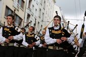
موسيقى بريتاني
فن الطهي
الجغرافيا
الأقاليم
Brittany comprises four departments : Morbihan, Finistère, Côtes-d'Armor, Ille-et-Vilaine
التجمعات السكنية الرئيسية
The following table is the list of towns in Brittany with a population over 15,000 inhabitants. Rennes is situated in the east of Brittany, being the capital of the region, the capital of the Ille-et-Vilaine department, as well as the most populous metropolitan area in Brittany with 700,000 inhabitants (2013).
| Town | Breton name | Population (2007)[46] |
Department |
|---|---|---|---|
| Rennes | Roazhon | 211,373 | Ille-et-Vilaine |
| Brest | Brest | 142,722 | Finistère |
| Quimper | Kemper | 63,961 | Finistère |
| Lorient | An Oriant | 58,135 | Morbihan |
| Vannes | Gwened | 52,984 | Morbihan |
| Saint-Malo | Sant-Maloù | 48,563 | Ille-et-Vilaine |
| Saint-Brieuc | Sant-Brieg | 46,178 | Côtes-d'Armor |
| Lanester | Lannarstêr | 22,598 | Morbihan |
| Fougères | Felger | 20,678 | Ille-et-Vilaine |
| Concarneau | Konk Kerne | 20,280 | Finistère |
| Lannion | Lannuon | 19,773 | Côtes-d'Armor |
| Plœmeur | Plañvour | 18,509 | Morbihan |
| Vitré | Gwitreg | 16,691 | Ille-et-Vilaine |
| Morlaix | Montroulez | 15,605 | Finistère |
| Douarnenez | Douarnenez | 15,436 | Finistère |
| Cesson-Sévigné | Saozon-Sevigneg | 15,261 | Ille-et-Vilaine |
| Bruz | Bruz | 15,031 | Ille-et-Vilaine |
المناخ

الاقتصاد
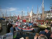
يعتبر صيد الأسماك الصناعة الرئيسية في بريتاني، ويبلغ مقدار الأسماك التي يصطادها البريتونز، ثلث المقدار السنوي الذي تصطاده فرنسا. كما تعتبر الزراعة، والسياحة، من الأنشطة المهمة لاقتصاد بريتاني.
النقل
الرموز

The modern flag of Brittany was designed in 1923. It is called Gwenn ha Du ("white and black" in Breton) and it features eleven ermine spots (their number may vary) and nine stripes, the black ones represent the Breton speaking historical dioceses, and the white ones symbolise the gallo speaking dioceses. The flag was created to replace the traditional ermine plain standard, considered too aristocratic and royalist. It was inspired by the American flag and the British Red Ensign.[47] Since the 1920s, the flag has become very popular and it is flown from a large number of institutions. Apart from the ermine flag, Breton historic banners include the Kroaz Du, a white flag with a black cross, the perfect negative of the Cornish flag.

The coat of arms of Brittany, ermine plain, was adopted by John III in 1316. Ermine had been used in Brittany long before, and there is no clue about its origin. It was probably chosen by the dukes because of its similarity with the French fleur-de-lis. The ermine, or stoat, as an animal became the badge of John IV at the end of the 14th century. It appeared later on numerous locations, including churches and castles. According to popular traditions, Anne of Brittany was hunting with her court when she saw a white ermine who preferred to die than to cross a dirty marsh. This episode would have inspired the duchess' motto : "Potius mori quam foedari" ("rather death than dishonour").[48] The motto has later been reused by Breton regiments, local World War II Resistants and cultural movements.
The Breton anthem, although not official, is Bro Gozh ma Zadoù – ("Old Land of My Fathers"). It re-employs both the Welsh anthem's music and that of "Bro Goth agan Tasow" (the national anthem of Cornwall; its lyrics were written at the end of the 19th century).
Colloquial Breton emblems include the Celtic triskelion, the menhirs and dolmens, local dishes such as the galettes, the Bigouden headdress and the traditional black round hat, the fisherman and his yellow raincoat, etc. BZH is a common abbreviation for "Breizh" ("Brittany" in Breton) and people often put BZH stickers on their car-plates, although it is forbidden under French laws.[49] .bzh is an approved Internet top level domain for the Breton culture and languages.[50][51]
معرض صور
-

-
 A dolmen in Plouharnel
 -
 The city wall of Guérande
 -
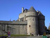
 Castle of Saint-Malo, Qui Qu'en Grogne Tower
 -

-
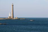 Île Vierge lighthouse
 -
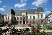 Parlement of Brittany in Rennes
 -
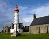 Abbey and lighthouse of Saint-Mathieu
 -
-
 Festival du chant de marin, sea songs festival in Paimpol
 -
 A Breton headdress from Batz-sur-Mer
 -
 Modern Brittany - Illustration from Legends & Romances of Brittany by Lewis Spence, illustrated by W. Otway Cannell.


المصادر
انظر أيضا
- Brittany (cultural region)
- Politics of Brittany
- Breton people
- Breton language
ملاحظات
- ^ Magnus Maximus was a native of Galicia in Spain, being born on the estate of Count Theodosius.
- ^ Presumably this soldier was in the employ of Gratian.
- ^ The Visigoths' version of events was that they had saved the Roman empire from a British invasion.
- ^ Brittany was proverbially wealthy throughout much of its history: it prospered from trade before and during Roman rule, mid-ninth century legal documents reveal peasant landowners suing lords for trespass. The House of Penthièvre was wealthy, Breton dowries raised impoverished nobles such as Jean II de Brosse to riches, and Duchess Anne's fortune contributed to the French Renaissance, to palaces such as Fontainebleau and to the Châteaux of the Loire Valley
المراجع
- ^ أ ب Henriette Walter (2013). L'aventure des langues en Occident: Leur origine, leur histoire, leur géographie. Robert Laffont. p. 113.
- ^ Meisel, Anna (15 سبتمبر 2013). "Is Great Britain really a 'small island'?". BBC. Retrieved 30 ديسمبر 2016.
- ^ "Saint-Michel tumulus". www.megalithes-morbihan.com. Retrieved 6 نوفمبر 2014.
- ^ "The world's 10 oldest ruins". The Telegraph. Retrieved 29 يونيو 2016.
- ^ "La Bretagne et son Histoire". bretagne.bzh (in الفرنسية). Rennes: Région Bretagne. 14 يناير 2019. Retrieved 26 يونيو 2019.
- ^ "Tableaux de l'économie française, Édition 2020, Villes et communes de France". INSEE. Retrieved 11 ديسمبر 2020.
- ^ "The Celtic League". The Celtic League. Retrieved 3 مايو 2011.
- ^ "Festival Interceltique de Lorient 2010". Festival Interceltique de Lorient. Archived from the original on 12 يونيو 2011. Retrieved 3 مايو 2011.
- ^ "Official website of the French Government Tourist Office: Brittany". Us.franceguide.com. Archived from the original on 11 يوليو 2011. Retrieved 3 مايو 2011.
- ^ Price, Glanville (30 مارس 1986). The Celtic connection. ISBN 9780861402489. Retrieved 3 مايو 2011.
- ^ Sharif Gemie (2007). Brittany 1750–1950 – The Invisible Nation. University of Wales Press.
- ^ Pierre-Yves Lambert (1997). La Langue Gauloise. p. 34.
- ^ Léon Fleuriot (1980). Les Origines de la Bretagne. Payot. pp. 53–54.
- ^ Léon Fleuriot (1980). Les Origines de la Bretagne. Payot. pp. 52–53.
- ^ Fabien Lecuyer (23 أبريل 2013). "Bertaèyn Galeizz change de nom. Un évènement pas si anodin". 7seizh. Archived from the original on 7 سبتمبر 2014. Retrieved 25 أبريل 2014.
- ^ Nathalie Molines and Jean-Laurent Monnier (1993). Le " Colombanien ": un faciès régional du Paléolithique inférieur sur le littoral armoricano-atlantique. Vol. 90. Bulletin de la Société préhistorique française. p. 284.
- ^ Thomas, Julian (1 ديسمبر 2004). "Current debates on the Mesolithic-Neolithic transition in Britain and Ireland". Documenta Praehistorica. 31. p. 117. doi:10.4312/dp.31.8. ISSN 1854-2492.
- ^ Mark Patton, Statements in Stone: Monuments and Society in Neolithic Brittany, Routledge, 1993, p.1
- ^ أ ب Venceslas Kruta (2000). Les Celtes, Histoire et Dictionnaire. Robert Laffont. p. 427. ISBN 2-7028-6261-6.
- ^ Giot (P. R), Briard (J.) and Pape (L.) (1995). Protohistoire de la Bretagne. Ouest-France Université. p. 370.
- ^ Julius Caesar. Commentarii de Bello Gallico. p. 75.
{{cite book}}:|work=ignored (help) - ^ أ ب Université de Rennes II (ed.). "Archéologie classique". Archived from the original on 31 مايو 2004. Retrieved 26 فبراير 2013.
- ^ Léon Fleuriot, Les origines de la Bretagne: l’émigration, Paris, Payot, 1980.
- ^ Smith, Julia M. H. Province and Empire: Brittany and the Carolingians, Cambridge University Press, 1992, pp.80–83.
- ^ Christian Y. M. Kerboul (1997). Les Royaumes brittoniques au très haut Moyen Âge. Éditions du Pontig/Coop Breizh. pp. 80–143. ISBN 2-9510310-3-3.
- ^ Joël Cornette (2005). Histoire de la Bretagne et des Bretons. Seuil. ISBN 2-02-054890-9.
- ^ Constance De La Warr, A Twice Crowned Queen: Anne of Brittany, Peter Owen, 2005
- ^ Joël Cornette, Le marquis et le Régent. Une conspiration bretonne à l'aube des Lumières, Paris, Tallandier, 2008.
- ^ "Breton American History". Archived from the original on 26 فبراير 2015. Retrieved 26 فبراير 2015.
- ^ "Rennes, guide histoire" (PDF). Archived from the original (PDF) on 18 يوليو 2011. Retrieved 3 مايو 2011.
- ^ Annales de Bretagne et des pays de l'ouest, (Anjou, Maine, Poitou, Touraine). Université d'Angers. 1976.
- ^ J. R. Rotté, Ar Seiz Breur. Recherches et réalisations pour un art Breton moderne, 1923–1947, 1987.
- ^ Jean Markale and Patrice Pellerin (1994). Une histoire de la Bretagne. Éditions Ouest France. p. 46. ISBN 2-7373-1516-6.
- ^ Mikael Bodlore-Penlaez and Divi Kervella (2011). Atlas de Bretagne – Atlas Breizh. Coop Breizh. p. 100. ISBN 978-2-84346-496-6.
- ^ Slate.fr, ed. (20 ديسمبر 2011). "Bretagne, la guerre des frontières".
- ^ Rue89, ed. (4 أبريل 2012). "La Bretagne, terre de résistance à l'extrême droite".
{{cite web}}: CS1 maint: numeric names: editors list (link) - ^ Plouméour-Ménez (ed.). "Le Roc'h RUZ, point culminant de la Bretagne". Archived from the original on 12 يونيو 2013. Retrieved 28 فبراير 2013.
- ^ أ ب Emmanuèle Savelli. Portail de l'information environnementale en Bretagne (ed.). "L'histoire géologique de la Bretagne". Archived from the original on 20 مارس 2013.
- ^ "Normales et records des stations météo de France – Infoclimat". Retrieved 30 ديسمبر 2016.
- ^ Bretagne Environnement, ed. (2005). "Les oiseaux marins : des falaises, des îlots, des embruns et des plumes". Archived from the original on 20 مارس 2013.
- ^ Bretagne Environnement, ed. (2005). "Les mammifères semi-aquatiques". Archived from the original on 25 مارس 2013.
- ^ Bretagne Environnement, ed. (2005). "Que sait-on des invertébrés continentaux en Bretagne ?". Archived from the original on 16 مايو 2013.
- ^ Bretagne Environnement, ed. (2005). "Les mammifères". Archived from the original on 25 يناير 2013.
- ^ Bretagne Environnement, ed. (2006). "Les plantes à fleur menacées en Bretagne". Archived from the original on 26 يناير 2013.
- ^ A Scene at the Sea
- ^ (بالفرنسية) INSEE: 2007 Legal population
- ^ Francis Favereau, Bretagne contemporaine – Culture, langue, identité? page 210, Skol Vreizh, Morlaix, 2005, ISBN 2-911447-72-7.
- ^ Gwenc'hlan Le Scouëzec, Guide de la Bretagne, page 40, Coop Breizh, Spézet, 1987; and Le Journal de la Bretagne des origines à nos jours, page 106, Larousse, Paris, 2001
- ^ "Fac-similé JO du 07/07/1967, page 06810 – Legifrance". Retrieved 30 ديسمبر 2016.
- ^ "The domain www.domainesinfo.fr is registered by NetNames". Retrieved 30 ديسمبر 2016.
- ^ "Delegated Strings – ICANN New gTLDs". Retrieved 30 ديسمبر 2016.
وصلات خارجية
- Brittany : in the West, the end of the world – Official French website (in English)
- Brittany at Curlie
- The official site for Brittany Tourism – Brittany Regional Tourist Board
- The official Région Bretagne website
الأمم الكلتية وثقافات أخرى | ||||||
|---|---|---|---|---|---|---|
| الأمم |
|  | ||||
| اللغات | ||||||
| أشخاص | ||||||
| Culture | ||||||
| Music | ||||||
| الرياضة | ||||||
| الحكومات العامة |
| .svg&filetimestamp=20250411001614&) |
|---|---|---|
| مقاطعات ومناطق صغرى | ||
| أقاليم أجنبية في 1789 | ||
| أفريقيا |  | |
|---|---|---|
| آسيا | ||
| أوروپا | ||
| أمريكا الشمالية | ||
| أوقيانوسيا | ||
| أمريكا الجنوبية | ||
| الاتحاد الروسي | ||
| أعضاء سابقون | ||
- Pages using gadget WikiMiniAtlas
- CS1 الفرنسية-language sources (fr)
- CS1 errors: periodical ignored
- CS1 maint: numeric names: editors list
- Short description is different from Wikidata
- Coordinates on Wikidata
- Use British English from October 2013
- Use dmy dates from May 2020
- Articles containing فرنسية-language text
- Articles containing بريتونية-language text
- Articles containing uncoded-language text
- Pages using infobox settlement with possible motto list
- Pages using infobox settlement with unknown parameters
- Pages using infobox settlement with no coordinates
- Pages using Lang-xx templates
- Pages with plain IPA
- Articles with hatnote templates targeting a nonexistent page
- Articles with unsourced statements from March 2021
- Articles with unsourced statements from October 2020
- Articles with Curlie links
- بريتاني
- مناطق فرنسا
- أقاليم التصنيف الثاني في الاتحاد الأوروپي
- أمم كلتية
- أعضاء منظمة الأمم والشعوب غير الممثلة
- Peninsulas of France