پالو
پالو
Palu | |
|---|---|
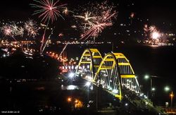
 منظر خليج پالو | |
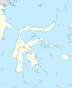
موقع پالو في سولاوسي | |
| الإحداثيات: 0°53′42″S 119°51′34″E / 0.89500°S 119.85944°E | |
| البلد | |
| Province | قالب:Country data Central Sulawesi |
| Incorporated | 27 September 1978 |
| وضع المدينة | 22 July 1994 |
| الحكومة | |
| • العمدة | هدايت |
| • Vice Mayor | سيگيت پورنومو شمس الدين سعيد |
| المساحة | |
| • الإجمالي | 395٫06 كم² (152٫53 ميل²) |
| المنسوب | 118 m (387 ft) |
| التعداد (2010) | |
| • الإجمالي | 335٬297 |
| • الكثافة | 850/km2 (2٬200/sq mi) |
| منطقة التوقيت | UTC+8 (Indonesia Central Time) |
| Area code | (+62) 451 |
| الموقع الإلكتروني | www |
پالو Palu مدينة مـُشهـَرة (كوتا) في جزيرة سولاوسي الإندونيسية، على بعد 1650 كم شمال شرق جاكرتا، على مصب نهر پالو. وهي عاصمة مقاطعة سولاوسي الوسطى على خليج طويل وضيق. وبسبب موقعها المحمي بين سلسلتي جبال، فالمناخ جاف بشكل غير معتاد. وفي تعداد 2010 كان بلغ سكان پالو نحو 336,300 نسمة، دون الأخذ في الاعتبار سكان regencies المجاورة.[1] وفي 28 سبتمبر 2018، عانت المدينة من مقتل أكثر من 1200 شخص بسبب تسونامي.[2]
الادارة
في عام 2010، تم تقسيم المدينة إلى أربع أقسام (kecamatan)، مجدولين أدناه بتعداداتهم في إحصاء 2010.[3]
| الاسم | التعداد تعداد 2010 |
|---|---|
| Palu Barat (West Palu) |
98,739 |
| Palu Selatan (South Palu) |
122,752 |
| Palu Timur (East Palu) |
75,967 |
| Palu Utara (North Palu) |
39,074 |
التاريخ
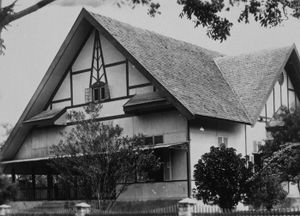
البلدة كانت جزءاً من الامبراطورية الهولندية حتى فازت إندونيسيا بإستقلالها في 1945–49. منزل الحاكم controleur الهولندي مازال باقياً كشاهد على تلك الحقبة.
الغارات الجوية من الـCIA
في أبريل 1958 أثناء تمرد پرمستا في شمال سولاوسي, the USA supported and supplied the rebels. Pilots from a CIA Taiwan-based front organisation, Civil Air Transport, flying CIA B-26 Invader aircraft, repeatedly bombed and machine-gunned targets in and around Palu; destroying vehicles, buildings, a bridge and a ship.[4]
زلزال 2005
On 24 January 2005 at 04:10 (UTC+8), an earthquake with a magnitude of 6.2 occurred in the city. According to the local meteorological office, the epicenter of the earthquake was around 1.249° S, 119.922° E, some 16 كيلومتر (10 ميل) southeast of Palu at the depth of 30 كيلومتر (19 ميل) of Bora Village's hot spring, Biromaru sub-district, Donggala Regency. Panic ensued as most people sought refuge in the highlands for fear of a repeat disaster like the tsunami as occurred in Aceh. The earthquake killed one person, injured four others, and destroyed 177 buildings.[5][6]
تفجير السوق 2005
On 31 December 2005 at about 07:35 (UTC +8) a bomb blast at a market at a stall selling pork killed eight people and injured 45 others.[7] An improvised explosive device, described as a nail bomb or similar,[8] detonated around 07:00 in a butcher's market mostly frequented by Christian Minahasa shopping for New Year's Eve celebrations, killing eight people and wounding another 53.[8][9][10]
تسونامي 2018
On 28 September 2018, Palu was hit by a 5-metre-high tsunami shortly after a magnitude 7.5 earthquake occurred 80 km north of the city, causing a large number of casualties.[11][12] As of 30 September, the death toll has jumped to 832 as reported by the Indonesian National Board for Disaster Management.[13]
المناخ
| بيانات المناخ لـ پالو | |||||||||||||
|---|---|---|---|---|---|---|---|---|---|---|---|---|---|
| الشهر | ينا | فب | مار | أبر | ماي | يون | يول | أغس | سبت | أكت | نوف | ديس | السنة |
| القصوى القياسية °س (°ف) | 38 (100) |
37 (99) |
37 (99) |
37 (99) |
35 (95) |
37 (99) |
37 (99) |
37 (99) |
38 (100) |
37 (99) |
37 (99) |
38 (100) |
38 (100) |
| متوسط القصوى اليومية °س (°ف) | 30 (86) |
30 (86) |
31 (88) |
31 (88) |
31 (88) |
31 (88) |
30 (86) |
31 (88) |
31 (88) |
31 (88) |
31 (88) |
30 (86) |
31 (88) |
| المتوسط اليومي °س (°ف) | 27 (81) |
27 (81) |
27 (81) |
28 (82) |
28 (82) |
27 (81) |
27 (81) |
27 (81) |
27 (81) |
28 (82) |
28 (82) |
27 (81) |
27 (81) |
| متوسط الدنيا اليومية °س (°ف) | 24 (75) |
24 (75) |
24 (75) |
25 (77) |
25 (77) |
24 (75) |
24 (75) |
24 (75) |
24 (75) |
25 (77) |
25 (77) |
25 (77) |
24 (75) |
| الصغرى القياسية °س (°ف) | 22 (72) |
21 (70) |
18 (64) |
20 (68) |
21 (70) |
21 (70) |
21 (70) |
20 (68) |
20 (68) |
17 (63) |
21 (70) |
21 (70) |
17 (63) |
| متوسط تساقط الأمطار mm (inches) | 101 (4.0) |
88 (3.5) |
90 (3.5) |
102 (4.0) |
130 (5.1) |
157 (6.2) |
158 (6.2) |
147 (5.8) |
164 (6.5) |
109 (4.3) |
110 (4.3) |
76 (3.0) |
1٬274 (50.2) |
| Average precipitation days | 7 | 8 | 9 | 9 | 10 | 12 | 11 | 9 | 8 | 7 | 9 | 7 | 106 |
| متوسط الرطوبة النسبية (%) | 75 | 76.5 | 75.5 | 76 | 75.5 | 76.5 | 77 | 74 | 74.5 | 73 | 73 | 74.5 | 75 |
| Source 1: weatherbase[14] | |||||||||||||
| Source 2: climate-data[15] | |||||||||||||
النقل
Palu is served by Mutiara Sis Al-Jufri Airport, which is located outside the city center.
المدن الشقيقة
Notable people
- Longki Djanggola, governor of the province
Indonesia Open Paragliding Championship
Indonesia Open Paragliding Championship is one of the world championship series which it was the first Indonesia Open held in the region on 19–25 June 2011. 78 paragliders taking part in the championship from Indonesia, Japan, Malaysia, the Philippines, Russia, South Korea and Switzerland competed at Wayu village (the Matantimali hills, 800 masl) about 30 كيلومتر (19 ميل) from Palu.[16]
الهامش
- ^ "HASIL SENSUS PENDUDUK 2010 SULAWESI TENGAH". Archived from the original on 18 February 2011. Retrieved 8 December 2010.
{{cite web}}: Unknown parameter|deadurl=ignored (|url-status=suggested) (help) - ^ "Large numbers of casualties in Indonesian city due to tsunami". MSN. Reuters. 29 September 2018. Retrieved 29 September 2018.
- ^ Biro Pusat Statistik, Jakarta, 2011.
- ^ Conboy, Kenneth; Morrison, James (1999). Feet to the Fire CIA Covert Operations in Indonesia, 1957–1958. Annapolis: Naval Institute Press. pp. 101, 105, 116, 118, 121. ISBN 1-55750-193-9.
- ^ "Indonesian quake causes panic". BBC News. 24 January 2005.
- ^ "EO Natural Hazards: Earthquake in Sulawesi".
- ^ "Indonesia bomb leaves eight dead". BBC News. 31 December 2005.
- ^ أ ب "Bombing kills eight at Indonesian market". USA Today. Associated Press. 31 January 2005. Retrieved 28 July 2011.
- ^ "At least eight killed in Indonesia market blast". CTV.ca News. 31 December 2005. Retrieved 28 July 2011.
- ^ "Indonesian police detain man after market bombing". ABC Australia. Reuters. 1 January 2006. Retrieved 28 July 2011.
- ^ (إنگليزية) "Tsunami hits Indonesia's Palu after strong earthquake". BBC News. 28 September 2018.
- ^ "BREAKING: Video shows tsunami hitting Palu after 7.7-magnitude quake". The Jakarta Post. 28 September 2018.
- ^ "Indonesia quake death toll 'at least 832'". BBC. Retrieved 30 September 2018.
- ^ "PALU, INDONESIA". weatherbase.com. Retrieved 15 July 2017.
- ^ "CLIMATE TABLE // HISTORICAL WEATHER DATA". climate-data.org. Retrieved 15 July 2017.
- ^ Maruli, Aditia (18 June 2011). "Indonesia hosts paragliding open championship in Palu". Antara News.
وصلات خارجية
 Media related to پالو at Wikimedia Commons
- (إندونيسية) Official site
- (إندونيسية) Step! Magz, Palu Youth Movement Magazine
- (إندونيسية) Sulteng.org – Tempat Ngumpulnya orang Palu


