لونج آيلاند
 Interactive map of Long Island
| ||||||||||||||||||||||||||||||||||||||||||||
| - | ||||||||||||||||||||||||||||||||||||||||||||
| ||||||||||||||||||||||||||||||||||||||||||||


لونگ آيلاند جزيرة تشكل الجزء الجنوبي الشرقي من ولاية نيويورك. عدد سكانها 6,861,474 نسمة. ويزيد عدد سكانها عن عدد سكان 41 ولاية من الخمسين ولاية المكونة للولايات المتحدة. تتكون الجزيرة من مناطق حضارية مزدحمة، وضواحٍ واسعة، ومدن سكنية صغيرة. وفي اتجاه الجزء الجنوبي الشرقي نجد مزارع وقرى للصيد ومراكز ونجوعًا. ويشكل مقطع من غربي لونج آيلاند جزءًا من مدينة نيويورك. With over eight million inhabitants as of 2020, it is the most populous island in the United States and the 18th-most populous island in the world. Just 0.35 miles (563 meters) from Manhattan at its western end, the island begins at New York Harbor and extends 118 ميل (190 km) eastward to the North Atlantic Ocean with a maximum north-south width of 23 ميل (37 km).[2][3] Long Island's land area of 1،401 ميل مربع (3،630 km2) makes it the largest island in the contiguous United States, 11th-largest in the nation, and 149th-largest in the world.[4]
Long Island is divided among four counties, with Kings (Brooklyn), Queens, and Nassau occupying its western third, and Suffolk its eastern two-thirds. As of 2020, more than half (58.4%) of New York City residents live geographically on Long Island in the boroughs of Brooklyn and in Queens,[5] although in common parlance, the term "Long Island", locally "the Island", refers exclusively to the counties of Nassau and Suffolk.[6] Conversely, locally, the term "the City" refers to Manhattan alone.[7] The Nassau-Suffolk-only definition of Long Island is recognized as a region by the State of New York.[8] Although geographically an island, the Supreme Court of the United States has held that given the island's extensive ties to the mainland, it should be treated as a peninsula, giving the state jurisdiction over its maritime boundaries.[9]
Long Island may refer both to the main island and the surrounding outer barrier islands. To its west, Long Island is separated from Manhattan and the Bronx by the East River tidal estuary. North of the island is Long Island Sound, across which lie Westchester County, New York, and the state of Connecticut. Across the Block Island Sound to the northeast is the state of Rhode Island. Block Island—which is part of Rhode Island—and numerous smaller islands extend further into the Atlantic. To the extreme southwest, Long Island, at Brooklyn, is separated from Staten Island and the state of New Jersey by Upper New York Bay, the Narrows, and Lower New York Bay.
With a population of 8,063,232 residents as of the 2020 U.S. census, constituting 40% of the State of New York's population,[10][11][12][13][14] Long Island is the most populated island in any U.S. state or territory, the third-most populous island in the Americas (after only Hispaniola and Cuba), 18th-most populous island in the world (ahead of Ireland, Jamaica, and Hokkaidō). Its population density is 5،859.5 inhabitants per square mile (2،262.4/km2). If Long Island geographically constituted an independent metropolitan statistical area, it would rank fourth most populous in the United States; if it were a U.S. state, Long Island would rank thirteenth in population and first in population density. Long Island is culturally and ethnically diverse, featuring some of the wealthiest and most expensive neighborhoods in the world near the shorelines, as well as working-class areas in all four counties.
As of 2020, Long Island had a gross domestic product of over US$200 billion. Median household income on the island significantly exceeds $100,000, and the median home price is approximately $600,000, with Nassau County approximating $700,000. Among residents over the age of 25, 42.6% hold a college degree or higher educationally.[15] Unemployment on Long Island stays consistently below 4%.
As a hub of commercial aviation, Long Island is home to two of the nation's and New York City metropolitan area's three busiest airports, JFK International Airport and LaGuardia Airport,[أ] in addition to Long Island MacArthur Airport; as well as two major air traffic control radar facilities, the New York TRACON and the New York ARTCC. Nine bridges and thirteen navigable tunnels (road and railroad tunnels but not metropolitan water tunnels) connect Brooklyn and Queens to the three other boroughs of New York City. Ferries connect Suffolk County northward across Long Island Sound to Connecticut. The Long Island Rail Road is the busiest commuter railroad in North America and operates continuously.[16] Biotechnology companies, engineering, and scientific research play a significant role in Long Island's economy,[17] including research facilities at Brookhaven National Laboratory, Cold Spring Harbor Laboratory, Stony Brook University, New York Institute of Technology, Plum Island Animal Disease Center, the New York University Tandon School of Engineering, the Zucker School of Medicine, and the Feinstein Institutes for Medical Research.
التاريخ
Early history


The first nations of Long Island used canoes as a source of transportation, and since they lived by the shores, they went fishing.[18][مطلوب مصدر أفضل] The fishermen used bows, arrows, and hooks to catch seafood such as crabs, scallops, and lobster.[19][مطلوب مصدر أفضل] The farmers used fish for fertilizer and planted vegetables such as corn, beans, and squash, which were popular among the indigenous people. They were exceptional farmers; they had a great understanding of how the weather and soil affected the crops.[20][مطلوب مصدر أفضل] Many of them hunted animals, such as deer, raccoon, and turkey in the forest.
وصل المكتشف هنري هدسون إلى لونج آيلاند عام 1609م، ثم استقر الهولنديون في الجزء الغربي من الجزيرة، بينما استقر الإنجليز الجدد في الجزء الشرقي منها خلال القرن السابع عشر الميلادي. وتُعدّ معركة لونج آيلاند التي وقعت في 27 أغسطس عام 1776م، واحدة من أهم معارك الثورة الأمريكية، حيث هزم الإنجليز الأمريكيين، لكن القوات المستعمرة هربت. في أوائل الأربعينيات من القرن التاسع عشر الميلادي تحولت الجزيرة إلى منطقة سكنية بعد بناء خط حديدي بطول الساحل الشمالي. وفي أوائل القرن العشرين، تم بناء مساكن فخمة في ناسو. وشهدت لونج آيلاند نموًا سريعًا بعد رصف شوارع رئيسية بها في منتصف القرن العشرين. وفيما بين عامي 1940و1960م تضاعف سكان مقاطعة ناسو ثلاث مرات، بينما تضاعف سكان مقاطعة سفولك أربع مرات.
الجغرافيا


تمتد جزيرة لونج آيلاند شرقاً من منطقة ناروز في خليج نيويورك لمسافة 190كم، وهي تغطي مساحة 4406م² وتُعدّ أكبر جزيرة في المنطقة خارج نطاق أرض الولايات المتحدة. وتنقسم الجزيرة عند نهايتها الشرقية إلى شبه جزيرتين ضيقتين، طول شبه الجزيرة الأولى، والمسماه فورك الشمالية حوالي40كم، بينما طول شبه الجزيرة الأخرى، والمسماة فورك الجنوبية 65كم. يتم الحفاظ على الجزيرة بامتداد ساحلها الجنوبي من المحيط، بإقامة شواطئ مانعة مثل شاطئ فايرلاند القومي، وشاطئ جونز، وشاطئ لونج وشاطئ وستهامبتون.
The westernmost end of Long Island contains the New York City boroughs of Brooklyn (Kings County) and Queens (Queens County). The central and eastern portions contain the suburban Nassau and Suffolk counties. However, colloquial usage of the term "Long Island" usually refers only to Nassau and Suffolk counties. For example, the Federal Reserve Bank of New York has a district named "Long Island (Nassau-Suffolk Metro Division)."[21] At least as late as 1911, locations in Queens were still commonly referred to as being on Long Island.[22] Some institutions in the New York City section of the island use the island's names, like Long Island University and Long Island Jewish Medical Center.
الجيولوجيا

السكان
| التعداد تاريخياً | |||
|---|---|---|---|
| الإحصاء | التعداد | %± | |
| 1790 | 37٬108 | ||
| 1800 | 42٬907 | 15.6% | |
| 1810 | 48٬752 | 13.6% | |
| 1820 | 56٬978 | 16.9% | |
| 1830 | 69٬775 | 22.5% | |
| 1840 | 110٬406 | 58.2% | |
| 1850 | 212٬637 | 92.6% | |
| 1860 | 379٬788 | 78.6% | |
| 1870 | 540٬648 | 42.4% | |
| 1880 | 743٬957 | 37.6% | |
| 1890 | 1٬029٬097 | 38.3% | |
| 1900 | 1٬452٬611 | 41.2% | |
| 1910 | 2٬098٬460 | 44.5% | |
| 1920 | 2٬723٬764 | 29.8% | |
| 1930 | 4٬103٬638 | 50.7% | |
| 1940 | 4٬600٬022 | 12.1% | |
| 1950 | 5٬237٬918 | 13.9% | |
| 1960 | 6٬403٬852 | 22.3% | |
| 1970 | 7٬141٬515 | 11.5% | |
| 1980 | 6٬728٬074 | -5.8% | |
| 1990 | 6٬861٬474 | 2.0% | |
| 2000 | 7٬448٬618 | 8.6% | |
| تقديري 2008 | 7٬713٬454 | 3.6% | |
| County |
Population تعداد 2000 |
% بيض |
% black or African American |
% آسيويون |
% غيرهم |
% mixed race |
% Hispanic/ Latino of any race |
% كاثوليك |
% not affiliated |
% يهود |
% Protestant |
Estimate of % not reporting | |
|---|---|---|---|---|---|---|---|---|---|---|---|---|---|
| Race | Ethnicity | الجماعات الدينية | |||||||||||
| Kings | 2,465,326 | 41.2% | 36.4% | 7.5% | 10.6% | 4.3% | 19.8% | 37% | 4% | 15% | 8% | 33% | |
| Queens | 2,229,379 | 44.1% | 20.0% | 17.6% | 12.3% | 6.1% | 25.0% | 29% | 37% | 11% | 5% | 15% | |
| Nassau | 1,334,544 | 79.3% | 10.1% | 4.7% | 3.8% | 2.1% | 10.0% | 52% | 9% | 16% | 7% | 15% | |
| Suffolk | 1,419,369 | 84.6% | 6.9% | 2.4% | 4.0% | 2.1% | 10.5% | 52% | 21% | 7% | 8% | 11% | |
| Totals | 7,448,618 | 57.2% | 21.2% | 9.0% | 8.6% | 4.0% | 17.8% | 40% | 18% | 12% | 7% | 20% | |
المقاطعات
تضم لونج آيلاند مقاطعات كنجز (بروكلين)، وكوينز، وناسو، وسفولك. وتشكل كلٌ من مقاطعتي كنجز وكوينز جزءًا رئيسياً من مدينة نيويورك، وتُعدّ صناعة الطائرات الصناعة الرائدة في لونج آيلاند، ومن الصناعات الرئيسية الأخرى الإلكترونيات والبلاستيك. وفي مقاطعة سفولك، يُعدّ الصيد في البحار العميقة وزراعة المحار والسياحة من الأنشطة الاقتصادية المهمة. كما تُعدّ الزراعة مصدر دخل، وتتركز المزارع في الجزء الشمالي الشرقي من المقاطعة، وفيها أيضاً معمل بروكهافن القومي وهو مركز للبحث العلمي.
الاقتصاد

معرض الصور
-

Mascot Dock- Village of Patchogue -

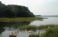
Swan River Long Island -
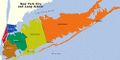
Long Island divided into counties. -

Port Jefferson ferry -

Barrier Islands boardwalk -

Old Field lighthouse -

Looking out from - Montauk Lighthouse. -

-
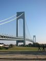
Verrazano-Narrows Bridge - Brooklyn to Staten Island -

-

Long Island Vineyards -

Citi Field Queens, NYC -

Corona Park Queens, NYC -
Stony Brook, NY -

2009 Jones Beach Airshow


انظر أيضاً
| لونج آيلاند
]].- List of Long Islanders, famous residents of Nassau and Suffolk
- List of people from New York City, including famous residents of Brooklyn and Queens
- List of references to Long Island places in popular culture
- Geography and environment of New York City
- Long Island Association
- Shoreham Nuclear Power Plant
- Long Island Marathon
المصادر
- ^ Richmond Hill Historic Society Archived مايو 15, 2013 at the Wayback Machine Tributary tribes
- ^ "Long Island Facts". LongIsland.com.
- ^ "Long Island". Encyclopædia Britannica (Britannica Concise ed.). Encyclopædia Britannica, Inc. 2011. 9370515. Archived from the original on November 5, 2007. Retrieved April 30, 2011.
- ^ John Burbidge (November 21, 2004). "Long Island at its Best; Who's the Longest of Them All?". The New York Times. Archived from the original on April 30, 2011. Retrieved April 30, 2011.
But the court wasn't saying Long Island isn't an island in a geographical sense", he continued. "In fact, all parties involved in the case agreed Long Island is a geographical island. It was only for the purposes of the case that the island was declared an extension of New York's coastline.
- ^ Annie Correal (August 12, 2021). "New York City adds 629,000 people, defying predictions of its decline". The New York Times. Archived from the original on December 28, 2021. Retrieved August 14, 2021.
- ^ "About Long Island". LongIsland.com. Archived from the original on May 16, 2015. Retrieved December 26, 2012.
Many people in the New York metropolitan area (even those on the island in Queens and Brooklyn) use the term "Long Island" or "the island" to refer to the more suburban Nassau and Suffolk counties only.
- ^ Jen Carlson (May 21, 2012). "Do You Refer To Manhattan As "The City"?". Gothamist. Archived from the original on October 25, 2016. Retrieved July 13, 2017.
- ^ Long Island Official Website of New York State. Retrieved March 4, 2021.
- ^ "Court Rules Long Island Legally Part of Mainland". Associated Press. February 19, 1985.
- ^ "Annual Estimates of the Resident Population: April 1, 2010 to July 1, 2015 - 2015 Population Estimates". United States Census Bureau. Archived from the original on May 15, 2016. Retrieved March 24, 2016.
- ^ "Kings County, New York QuickFacts". U.S. Census Bureau. Archived from the original on February 17, 2016. Retrieved March 24, 2016.
- ^ "Queens County, New York QuickFacts". U.S. Census Bureau. Archived from the original on August 8, 2014. Retrieved March 24, 2016.
- ^ "Nassau County, New York QuickFacts". U.S. Census Bureau. Archived from the original on June 7, 2011. Retrieved March 24, 2016.
- ^ "Suffolk County, New York QuickFacts". U.S. Census Bureau. Archived from the original on June 24, 2011. Retrieved March 24, 2016.
- ^ "Long Island" at New York Fed
- ^ "Transit Ridership Report Fourth Quarter and End-of-Year 2014" (PDF). American Public Transportation Association (APTA). March 3, 2015. Archived from the original (PDF) on October 11, 2017. Retrieved October 28, 2016.
- ^ [1] Archived نوفمبر 16, 2016 at the Wayback Machine Accessed November 16, 2016.
- ^ "Long Island Indians and The Early Settlers". longislandgenealogy.com. Archived from the original on March 29, 2013. Retrieved November 7, 2019.
- ^ "Long Island Indian Tribes- Richmond Hill Historical Society". www.richmondhillhistory.org. Archived from the original on October 28, 2019. Retrieved November 7, 2019.
- ^ "Hudson Valley's Tribal History". www.westchestermagazine.com. Archived from the original on November 7, 2019. Retrieved November 7, 2019.
- ^ "Long Island (Nassau-Suffolk Metro Division)". Federal Reserve Bank of New York. August 2011. Archived from the original on October 13, 2012. Retrieved June 24, 2012.
- ^ "The Real Estate Field – On Long Island" (PDF). The New York Times. December 11, 1911. Archived (PDF) from the original on September 16, 2018. Retrieved April 30, 2011.
- ^ خطأ استشهاد: وسم
<ref>غير صحيح؛ لا نص تم توفيره للمراجع المسماةCensus2000 - ^ The Association of Religion Data Archives (ARDA), Year 2000 Report Churches were asked for their membership numbers. ARDA estimates that most of the churches not reporting were black Protestant congregations.
وصلات خارجية

40°48′N 73°18′W / 40.8°N 73.3°W
خطأ استشهاد: وسوم <ref> موجودة لمجموعة اسمها "lower-alpha"، ولكن لم يتم العثور على وسم <references group="lower-alpha"/>
- CS1: Julian–Gregorian uncertainty
- Pages using gadget WikiMiniAtlas
- Short description is different from Wikidata
- Articles with hatnote templates targeting a nonexistent page
- كل المقالات بدون مراجع موثوقة
- كل المقالات بدون مراجع موثوقة from December 2020
- Coordinates on Wikidata
- لونگ آيلاند
- Proposed states and territories of the United States
- جزر مدينة نيويورك
- صفحات مع الخرائط