ناغانو (مدينة)
Nagano
長野市 | |||||||||||
|---|---|---|---|---|---|---|---|---|---|---|---|
 From top of left, Zenkoji, Mount Togakushi, Kinasa village, Nagano Big Hat arena, Aerial in Kawanakajima, Oku-Subana Valley, headquarters of Marukome (famous miso manufacturing company) in Nagano, Oyaki Japanese sweets, Togakushi ski resort, and Matsushiro Castle | |||||||||||
 Flag  الشعار | |||||||||||
 Location of Nagano in Nagano Prefecture | |||||||||||
 | |||||||||||
 Nagano | |||||||||||
| الإحداثيات: 36°38′55″N 138°11′41″E / 36.64861°N 138.19472°E | |||||||||||
| البلد | اليابان | ||||||||||
| المنطقة | تشوبو (كوشينإتسو) | ||||||||||
| المحافظة | ناگانو | ||||||||||
| الحكومة | |||||||||||
| • Mayor | Kenji Ogiwara[1] | ||||||||||
| المساحة | |||||||||||
| • الإجمالي | 834٫81 كم² (322٫32 ميل²) | ||||||||||
| التعداد (June 1, 2019) | |||||||||||
| • الإجمالي | 370٬632 | ||||||||||
| • الكثافة | 440/km2 (1٬100/sq mi) | ||||||||||
| منطقة التوقيت | UTC+9 (Japan Standard Time) | ||||||||||
| Phone number | 026-226-4911 | ||||||||||
| Address | 1613 Midori-chō, Nagano-shi, Nagano-ken 380-8512 | ||||||||||
| Climate | Cfa/Dfa | ||||||||||
| الموقع الإلكتروني | Official website | ||||||||||
| |||||||||||
ناگانو (長野市, Nagano-shi, تـُنطق [nagaꜜno ɕi])، هي مدينة في اليابان، تقع في وسط جزيرة هونشو (أكبر جزر البر الياباني)، عاصمة محافظة ناگانو. تبلغ مساحتها الإجمالية 404.35 كلم² وتعداد سكانها 361,221 نسمة (2003 م). من أهم الصناعات فيها الحرير، والأنسجة المطبوعة (كيمونو، ستائر وغيرها)، إلى جانب بعض الصناعات الميكانيكية.
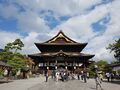
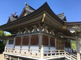
تأسست المدينة في 1 أبريل 1897. ناگانو والتي كانت تُعرف باسمها القديم "زِنكو-جي"، تشتهر بمعبدها البوذي (زنكو-جي)، والذي يضُم أقدم عمل فني يصور شخصية بوذا في اليابان، تمثال من البرونز يرجع تاريخه إلى القرن الـ6 قبل الميلاد. استضافت المدينة الألعاب الأولمبية الشتوية لعام 1989.
استعراض
Nagano City, located in the former Shinano Province, developed from the Nara period (AD 710 to 794) as a temple town (monzen machi). The city of Nagano is home to Zenkō-ji, a 7th-century Buddhist temple that is listed as a Japanese national treasure. Zenkō-ji was established in its current location in 642 AD. The location of Zenkō-ji is approximately 2 kilometers from the present-day central Nagano Station. During the Sengoku Period, the Age of Warring States, Nagano was the site of a series of battles, the Battles of Kawanakajima, between 1553 and 1564. During the Edo period (1603 and 1868), as the city developed, Nagano became an important post station (shukuba) on the Hokkoku Kaidō highway which connected Edo (present day Tokyo) with the Sea of Japan coast. Following the Meiji restoration, Nagano became the first established modern town in Nagano prefecture on April 1, 1897.
The city of Nagano and several surrounding communities hosted the 1998 Winter Olympics and the 1998 Winter Paralympics. Nagano City is an important historical location, an industrial center, as well as a travel destination and a center for accessing surrounding sightseeing spots, including Japan's onsen-bathing snow monkeys in Yamanouchi and world-class ski resorts of Hakuba, Shiga Kogen and Nozawaonsen - throughout the year.
الألعاب الأولمبية الشتوية 1998
Nagano, along with the neighboring communities of Hakuba village, Nozawaonsen, Yamanouchi, Iizuna, and Karuizawa hosted the 1998 Winter Olympics from February 7 to February 22 and the Paralympics from March 5 to March 14. This was the third Olympic Games and second Winter Olympic Games to be held in Japan, after the 1964 Summer Olympics in Tokyo, and the 1972 Winter Olympics in Sapporo (the first Winter Games ever held in Asia). As of 2019, Nagano was the southernmost host of the Winter Olympic Games. The Nagano Olympic Commemorative Marathon is held annually to commemorate the occasion.
One important legacy of the Games was an improved transportation network. In order to improve access to Nagano in advance of the Games, Nagano was linked to the high-speed shinkansen train network. The Nagano Shinkansen (now the Hokuriku Shinkansen) was inaugurated five months before the start of the Games, and during the Winter Olympics carried 655,000 passengers.[2] In addition, both Nagano Station and Shinonoi Station were expanded, and Imai Station in the Kawanakajima area was built to access the Athletes village. Finally, the Nagano Expressway and the Jōshin-etsu Expressway were built in the Nagano region,[3] and another 114.9 kilometers of roads within Nagano Prefecture were improved.[4]
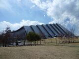
In addition to a transportation legacy, several world-class venues of the 1998 Winter Olympics were built, including M-Wave, Japan's first International Skating Union (ISU) standard indoor 400m double-track,[5] and which happens to be one of the largest hanging wooden roof structures in the world.[6] Finally, the Athletes Village beside the newly constructed Imai Station was built in advance of the Games by the city of Nagano as future public residential housing, and loaned to the Nagano Olympic Organizing Committee during the Games.[7] A Media Village, composed of a four-block 10-12 storey apartment complex named Asahi Danchi, was built in the Asahi district of Nagano, across the street from the M-Wave.[8][9] Asahi Danchi now includes private sector housing as well as housing for government employees.[10]
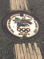
Stylized manhole cover displaying the Nagano Olympics emblem, with tactile paving
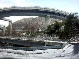
Asagawa Loop Line to Iizuna Kogen Ski Area built in preparations for the 1998 Winter Olympics


أفق المدينة
Matsushiro Castle(2010)
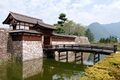
Zenkō-ji(2018)
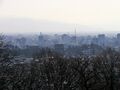
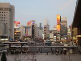
Skyline of Nagano City(2019)
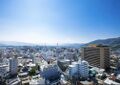
CBD of Nagano(2022)
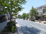
Downtown Gondō(2011)

.jpg&filetimestamp=20230701023405&)


الجغرافيا
Nagano is located in north-central Nagano Prefecture, in the Nagano Basin (Zenkoji Daira), surrounding by mountains, near the confluence of the Chikuma River and the Sai River. The Sai River in Nagano should not be confused with the Sai River (Gifu) even though both rivers have the same kanji and reading, 犀川 (Saigawa). Other important rivers include the Susobana River, which originates in the Togakushi highland area; and the Torii River, which also originates in the Togakushi highland area. The Chikuma River is 367.0 km, with 29.5 km within the Nagano city limits; the Sai River is 157.7 km, with 44.2 km in Nagano; all 40.1 km of Susobana River are in Nagano City, and 10.4 km of the 34.8 km-long Torii River are in Nagano[11] Myōkō-Togakushi Renzan National Park, Jōshin'etsu-kōgen National Park and Chūbu-Sangaku National Park are each partially located within Nagano City.
The present-day core city of Nagano includes the districts and former towns of Nagano, Shinonoi, Matsushiro, Wakaho, Kawanakajima, Kohoku, Naniai, Shinkomachi, Toyono, Togakushi, Kinasa, Ooka, Shinshushincho, Nakajo.
الجبال المحيطة


- Mount Takatsuma, 2,353 m, straddles Myōkō, Niigata and Nagano City. It is the highest peak of the Togakushi mountain range, is one of 100 Famous Japanese Mountains, and due to its pyramidal shape it is also known as Togakushi Fuji.[12] Takatsuma is the highest point in Nagano City. The lowest point is located in the Asano area of Toyono, 327.4 meters above sea level.
- Mount Iizuna, 1,917 meters, is a popular area for skiing and is where the Spiral, bobsleigh and luge track for the 1998 Winter Olympics, is located.
- Mount Togakushi, 1,904 m, is located in Nagano City.
- Mount Hijiri, 1,447 m. is located along the border between Nagano City, and Omi in Higashichikuma District, Nagano.
- Daibou Pass, 1,055 m, is located in Nagano City, on the border of Togakushi and Kinasa, Nagano.
- Iizuna Kogen, 1,000 m, is a highland area that extends to the south base of Mount Iizuna in Nagano City.
- Mount Mododori, 744 m, spans northern Nagano City, and Iizuna town. It is a monogenetic volcano that was active approximately 200,000 years ago.
- Mount Dizuki, 733 m, is located on the northwest side of Nagano City.
- Mount Minakami, 659 m, is a lava dome in Matsushiro in Nagano City. Its relative height to the surrounding landscape is 280 m.
المناخ
Like most of Honshū, Nagano has a humid subtropical climate, although its location in a sheltered inland valley means it receives less precipitation than any part of Japan outside Hokkaidō. The city still receives heavy winter snow totaling 2.57 متر (101 in) over four months from December to March, but it is less gloomy during these cold months than the coast from Hagi to Wakkanai.
| بيانات المناخ لـ ناگانو، اليابان (1981–2010) | |||||||||||||
|---|---|---|---|---|---|---|---|---|---|---|---|---|---|
| الشهر | ينا | فب | مار | أبر | ماي | يون | يول | أغس | سبت | أكت | نوف | ديس | السنة |
| القصوى القياسية °س (°ف) | 18.1 (64.6) |
22.5 (72.5) |
24.4 (75.9) |
30.8 (87.4) |
32.6 (90.7) |
35.6 (96.1) |
37.9 (100.2) |
38.7 (101.7) |
36.3 (97.3) |
32.2 (90.0) |
26.2 (79.2) |
21.3 (70.3) |
38.7 (101.7) |
| متوسط القصوى اليومية °س (°ف) | 3.5 (38.3) |
4.7 (40.5) |
9.5 (49.1) |
17.3 (63.1) |
22.5 (72.5) |
25.7 (78.3) |
29.1 (84.4) |
31.0 (87.8) |
25.6 (78.1) |
19.2 (66.6) |
13.0 (55.4) |
6.8 (44.2) |
17.3 (63.1) |
| متوسط الدنيا اليومية °س (°ف) | −4.1 (24.6) |
−3.8 (25.2) |
−0.8 (30.6) |
4.9 (40.8) |
10.5 (50.9) |
15.8 (60.4) |
20.0 (68.0) |
21.3 (70.3) |
16.9 (62.4) |
9.7 (49.5) |
3.1 (37.6) |
−1.6 (29.1) |
7.66 (45.79) |
| الصغرى القياسية °س (°ف) | −17 (1) |
−16.4 (2.5) |
−14.6 (5.7) |
−6.5 (20.3) |
−1.8 (28.8) |
3.9 (39.0) |
10.2 (50.4) |
10.7 (51.3) |
5.5 (41.9) |
−1.9 (28.6) |
−11.4 (11.5) |
−15.2 (4.6) |
−17 (1) |
| متوسط تساقط الأمطار mm (inches) | 51.1 (2.01) |
49.8 (1.96) |
59.4 (2.34) |
53.9 (2.12) |
75.1 (2.96) |
109.2 (4.30) |
134.4 (5.29) |
97.8 (3.85) |
129.4 (5.09) |
82.8 (3.26) |
44.3 (1.74) |
45.5 (1.79) |
932.7 (36.71) |
| متوسط هطول الثلج cm (inches) | 98 (39) |
82 (32) |
27 (11) |
3 (1.2) |
0 (0) |
0 (0) |
0 (0) |
0 (0) |
0 (0) |
0 (0) |
2 (0.8) |
45 (18) |
257 (102) |
| Average precipitation days (≥ 0.5 mm) | 13.0 | 11.5 | 12.0 | 9.2 | 10.0 | 11.4 | 13.1 | 9.8 | 11.7 | 9.1 | 8.6 | 10.4 | 129.8 |
| متوسط الرطوبة النسبية (%) | 78 | 74 | 68 | 61 | 64 | 70 | 74 | 72 | 74 | 75 | 76 | 77 | 72 |
| Mean monthly ساعات سطوع الشمس | 127.2 | 131.3 | 168.5 | 198.3 | 207.3 | 162.2 | 168.8 | 204.3 | 141.7 | 152.4 | 139.1 | 135.6 | 1٬936٫7 |
| Source 1: Japan Meteorological Agency[13] | |||||||||||||
| Source 2: Japan Meteorological Agency (records)[14] | |||||||||||||
الديمغرافيا
The population of Nagano City has declined by 10,000 since the mid-1990s. As of April 1, 2019, the city had a total population of 376,080 people, made up of 193,982 women and 182,098 men in 160,625 households.[15]
التعداد التاريخي
| السنة | تعداد | ±% |
|---|---|---|
| 1920 | 212٬182 | — |
| 1925 | 222٬141 | +4.7% |
| 1930 | 234٬503 | +5.6% |
| 1935 | 239٬513 | +2.1% |
| 1940 | 241٬716 | +0.9% |
| 1945 | 295٬090 | +22.1% |
| 1950 | 300٬756 | +1.9% |
| 1955 | 303٬435 | +0.9% |
| 1960 | 303٬458 | +0.0% |
| 1965 | 310٬399 | +2.3% |
| 1970 | 322٬825 | +4.0% |
| 1975 | 342٬120 | +6.0% |
| 1980 | 358٬173 | +4.7% |
| 1985 | 369٬023 | +3.0% |
| 1990 | 377٬261 | +2.2% |
| 1995 | 387٬359 | +2.7% |
| 2000 | 387٬911 | +0.1% |
| 2005 | 386٬572 | −0.3% |
| 2010 | 381٬511 | −1.3% |
| 2015 | 377٬598 | −1.0% |
| 2020 | 372٬760 | −1.3% |
Population of districts of the current Core City of Nagano
The growth and decline of the population within the various districts of Nagano City has been uneven over the past 70 years[16]
| Year | Total | Nagano | Shinonoi | Matsushiro | Wakaho | Kawanakajima | Kohoku | Naniai | Shinkomachi | Toyono | Togakushi | Kinasa | Ooka | Shinshushincho | Nakajo |
|---|---|---|---|---|---|---|---|---|---|---|---|---|---|---|---|
| 1947 | 295,348 | 136,353 | 30,318 | 27,906 | 13,242 | 11,053 | 12,783 | 4,891 | 6,500 | 9,930 | 10,205 | 6,170 | 4,670 | 14,240 | 7,087 |
| 1950 | 300,756 | 143,494 | 30,068 | 27,131 | 13,063 | 10,794 | 12,807 | 4,911 | 6,385 | 9,869 | 10,281 | 6,209 | 4,560 | 14,040 | 7,144 |
| 1955 | 303,684 | 152,547 | 29,062 | 25,485 | 12,312 | 10,432 | 12,655 | 4,870 | 6,067 | 9,787 | 9,697 | 6,007 | 4,351 | 13,511 | 6,901 |
| 1960 | 303,458 | 160,522 | 29,329 | 22,626 | 11,938 | 10,403 | 12,331 | 4,419 | 5,503 | 9,604 | 8,709 | 5,373 | 4,035 | 12,354 | 6,312 |
| 1965 | 310,399 | 172,836 | 29,304 | 21,451 | 11,404 | 10,975 | 14,228 | 3,962 | 4,964 | 9,110 | 7,547 | 4,397 | 3,405 | 11,324 | 5,456 |
| 1970 | 322,825 | 187,216 | 30,633 | 20,496 | 11,739 | 12,551 | 14,630 | 3,571 | 4,519 | 9,283 | 6,475 | 3,763 | 2,924 | 10,188 | 4,837 |
| 1975 | 342,120 | 198,224 | 34,493 | 19,968 | 12,317 | 16,102 | 18,140 | 3,190 | 4,203 | 9,539 | 6,225 | 3,603 | 2,477 | 9,323 | 4,316 |
| 1980 | 358,173 | 208,703 | 36,432 | 20,786 | 12,766 | 17,314 | 21,321 | 2,995 | 4,043 | 9,633 | 6,074 | 3,223 | 2,249 | 8,616 | 4,018 |
| 1985 | 369,023 | 216,306 | 37,516 | 21,224 | 12,934 | 18,473 | 23,609 | 3,053 | 3,848 | 9,701 | 5,866 | 2,864 | 2,103 | 7,881 | 3,635 |
| 1995 | 377,261 | 223,191 | 38,444 | 21,110 | 12,646 | 19,790 | 25,418 | 2,866 | 3,561 | 9,700 | 5,608 | 2,686 | 1,753 | 7,143 | 3,345 |
| 1995 | 387,359 | 229,952 | 39,601 | 20,790 | 12,687 | 21,624 | 27,928 | 2,633 | 3,301 | 9,819 | 5,218 | 2,523 | 1,602 | 6,596 | 3,085 |
| 2000 | 387,911 | 228,431 | 39,233 | 19,904 | 12,503 | 24,997 | 29,599 | 2,399 | 3,046 | 10,005 | 4,938 | 2,333 | 1,544 | 6,093 | 2,886 |
| 2005 | 386,572 | 227,758 | 39,981 | 18,873 | 12,661 | 25,669 | 30,879 | 2,118 | 2,768 | 10,016 | 4,467 | 1,983 | 1,389 | 5,535 | 2,525 |
| 2010 | 381,511 | 223,787 | 40,380 | 18,161 | 12,570 | 26,416 | 32,075 | 1,873 | 2,434 | 9,825 | 3,986 | 1,700 | 1,154 | 4,892 | 2,258 |
| 2015 | 377,598 | 221,404 | 41,340 | 17,100 | 12,201 | 26,881 | 33,486 | 1,622 | 2,051 | 9,609 | 3,499 | 1,393 | 960 | 4,135 | 1,917 |
Foreign and non-Japanese residents
The following table shows the population of foreigners and non-Japanese residents since 2014[17]
| Year | Total | Chinese | Korean | Filipino | Vietnamese | Thai | Other |
|---|---|---|---|---|---|---|---|
| 2014 | 3,394 | 1,619 | 587 | 301 | 136 | 219 | 532 |
| 2015 | 3,475 | 1,612 | 571 | 320 | 195 | 226 | 551 |
| 2016 | 3,475 | 1,595 | 542 | 319 | 248 | 239 | 552 |
| 2017 | 3,576 | 1,576 | 536 | 336 | 314 | 241 | 573 |
| 2018 | 3,715 | 1,563 | 557 | 344 | 392 | 242 | 617 |
البلديات المحيطة

- Shinano, located approximately 20 kilometers north of Nagano. Lake Nojiri is found in Shinano. Lake Nojiri was home to Kokusaimura (International Village), a landownership association, made up principally of Christian missionaries who had cottages there from the early 20th Century.
When we first went to Lake Nojiri, the International Village was like an island of affluence in a sea of poverty. But, as the Japanese economy recovered from the war, the scales tipped until we became an island of poverty in a sea of affluence.[18]
— Alden Matthews، My Three Worlds (2007)
- Nakano, located in the Zennoji Plain, on the Chikuma River and surrounded by mountains, experienced significant growth after the 1998 Winter Olympics.
- Suzaka, a former castle town (jōkamachi) during the Edo period Tokugawa shogunate on the opposite side of the Chikuma River from Nagano. The city was noted in the Meiji period for its silk industry. After World War II, an electronics industry was established. The city is also noted for apples and grapes, and the Prefectural Agricultural Research Station is located there.
- Obuse, an important historical tourist town, approximately 30 minutes by Nagano Electric Railway train from Nagano Station. Obuse is home to a Hokusai museum, and Gansho-in, a Buddhist temple, has a ceiling painted by him. The largest hospital in the town, a former tuberculosis sanatorium, was built in the 1930s by J. G. Waller and the Anglican Church of Canada.[19]
- Ueda, approximately 35 kilometers south of Nagano, was a former castle town of the Ueda Domain under the Tokugawa shogunate. The ruins of Ueda Castle are an important historical site in the city.
- Chikuma, located approximately 20 kilometers south of Nagano, includes numerous burial tombs (tumuli) from the Kofun period. During the Nara period, several important Man'yōshū poems were set here. The area around Chikuma prospered during the Edo period as several post stations along the pilgrimage route to the famed Zenkō-ji were located here. Obasute Station, a switchback station is located here.
- Ōmachi is approximately 40 kilometers west of Nagano. The Hida Mountains, also called the Japanese Northern Alps, with 3000m peaks surround Ōmachi. The area was part of the holdings of Matsumoto Domain during the Edo period.
- Omi is approximately 30 kilometers southwest of Nagano Station. The town is in the Hijiiri Highlands, and Hijiri-Kōgen Station is located here, as is Kitayama Dam.
- Chikuhoku is located in the Matsumoto Basin, and the Higashijo Dam and Onikuma Dam are located here. Most of the area was under the control of Matsumoto Domain during the Edo period.
- Ikusaka is approximately 50 kilometers southwest of Nagano, in the center of Nagano Prefecture. Two dams, Ikusaka Dam and Taira Dam are found here. The area of present-day Ikusaka was part of the holdings of Matsumoto Domain during the Edo period.
- Ogawa is approximately 20 kilometers west of Nagano. It is listed as one of The Most Beautiful Villages in Japan. It is an important agriculture center, primarily rice cultivation.
- Hakuba, located 45 km west of Nagano Station, is an internationally renowned ski resort town in the northern Japan Alps. The surrounding valley has an annual snow fall of over 11 meters, and the 10 ski resorts have more than 200 runs. The village was an important site for 1998 Winter Olympics (Alpine skiing, ski jumping, and cross-country). Most of Hakuba is located in Chūbu-Sangaku National Park.
- Otari is located approximately 55 kilometers northwest of Nagano Station. It is in the mountainous far northwest of Nagano Prefecture, bordered by Niigata Prefecture to the north and west. Much of the village is within the borders of the Chūbu-Sangaku National Park or the Myōkō-Togakushi Renzan National Park.
- Myōkō, on the border of Nagano Prefecture, lies in mountains surrounding the historical entrance to the Echigo Plains. The city is surrounded by five mountains. Madarao, Myōkō, Kurohime, Togakushi and Iizuna are collectively known as the Five Peaks of Northern Shinano (Hokushingogaku). Mount Myōkō (2,454 m) is in the city, much of which is within the borders of the Myōkō-Togakushi Renzan National Park.
الثقافة
أحداث
- Nagano Tomyo Festival is a light and lantern festival held every February to commemorate the 1998 Winter Olympics.
- Nagano Olympic Commemorative Marathon, an IAAF Bronze Label Road Race, takes place in mid-April.
- Hanami - cherry blossom viewing - in Joyama Park behind Zenkō-ji is possible from mid-to-late April.
- Nagano Floral Festa Zenkoji Temple - flowers and flower art at Nagano Station and Omotesando - held in early May to welcome spring.
- Buckwheat blossom viewing, mid-July to mid-September, Togakushi
- Kijo ("Ogress") Momoji Festival held in mid-October in Iizuna, celebrates this woman and the beauty of nature.
- Togakushi Soba Festival, early November
- Yoi Ebisu and Ebisuko Fireworks display, dedicated to the god of fortune, Ebisu held in late November.
الرياضة
- Nagano Sports Park is a municipal and prefectural sporting ground that includes the Aqua Wing Arena, Nagano Athletic Stadium, tennis courts, a baseball stadium, and a gymnasium. The sports park is accessible by Bus 7 from Nagano Station, or a 15-minute walk from Asahi Station on the Nagano Electric Railway.
- AC Nagano Parceiro is a Japanese football club based in Nagano that represents Nagano in J3 League.
- AC Nagano Parceiro Ladies, based in Nagano, is a women's football team that currently plays in the Nadeshiko League 1, the highest division of women's football in Japan.
- Shinshu Brave Warriors is a professional basketball team that competes in the second division of the Japanese B.League.[20]
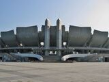
- Shinano Grandserows are an independent minor baseball team that plays in the Baseball Challenge League (Route Inn BCL) in Nagano City, at the Nagano Olympic Stadium.
- Boaluz Nagano are a futsal team in the F. League. They play at the White Ring (arena).
- Nagano City Gliding Field, which opened in 1974, is located in the Wakaho district of Nagano City along the Chikuma River.
| Club | Sport | League | Venue | Established |
|---|---|---|---|---|
| AC Nagano Parceiro | Soccer | J.League | Minami Nagano Sports Park Stadium | 1990 |
| AC Nagano Parceiro Ladies | Soccer | WE.League | Minami Nagano Sports Park Stadium | 2000 |
| Shinano Grandserows | Baseball | BC.League | Nagano Olympic Stadium | 2006 |
| Boaluz Nagano | Futsal | F.League | White Ring | 2011 |
| Shinshu Brave Warriors | Basketball | B.League | White Ring | 2011 |


معرض صور
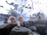
Japanese macaque at Jigokudani hotspring
Yushimatennmangu
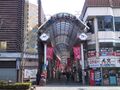
Downtown Nagano
Daimon-cho
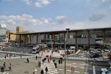
Nagano Station, Zenkō-ji Entrance
M-Wave arena
Nagano Olympic Stadium (Nagano Baseball Stadium)
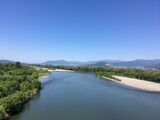
Chikuma River, from Yashima Bridge
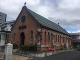
Nagano Holy Saviour (Anglican) Church (est. 1898), a nationally registered Tangible Cultural Property
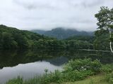
Kagami-ike Pond, in Togakushi, Nagano 2019
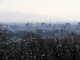
Skyline of Nagano City


الهامش
- ^ "歴代長野市長 (trans. Mayors of Nagano City)". Nagano City. Nagano City Official Website. Retrieved 17 November 2021.
- ^ Hanazawa, Nahomi (1999). Official Report of the 1998 Winter Olympic Games, Vol. 2: Sixteen Days of Glory. Nagano: NAOC. p. 309. ISBN 4784098267. Retrieved 9 May 2019.
- ^ Hanazawa, Nahomi (1999). Official Report of the 1998 Winter Olympic Games, Vol. 2: Sixteen Days of Glory. Nagano: NAOC. p. 301. ISBN 4784098267. Retrieved 9 May 2019.
- ^ "Transport infrastructure provides lasting legacy of Nagano 1998". International Olympic Committee. Retrieved April 18, 2019.
- ^ M-Wave Corporation. "About M-Wave". www.nagano-mwave.co.jp/m_wave/language/en.php (in الإنجليزية). Retrieved 2019-04-06.
- ^ M-Wave Corporation. "About M-Wave". www.nagano-mwave.co.jp/m_wave/language/en.php (in الإنجليزية). Retrieved 2019-04-06.
- ^ Hanazawa, Nahomi (1999). Official Report of the 1998 Winter Olympic Games, Vol. 2: Sixteen Days of Glory. Nagano: NAOC. p. 240. ISBN 4784098267. Retrieved 9 May 2019.
- ^ Journal of Snow Engineering of Japan. "Outline of the Nagano Olympics, the game facilities, etc". www.jstage.jst.go.jp/article/jsse1986/13/4/13_4_381/_pdf (in اليابانية). Retrieved 2019-04-10.
- ^ Shinano Mainichi Shimbun. "Nagano Winter Olympics Venues". www.shinmai.co.jp/feature/olympic/kaijo/index.htm (in اليابانية). Retrieved 2019-04-10.
- ^ Nagano Prefecture. "About the present conditions of facilities of Nagano Winter Olympics". www.pref.nagano.lg.jp/koho/kensei/koho/hotline/201606/hot_201606-20.html (in اليابانية). Retrieved 2019-04-10.
- ^ "長野市統計書". Nagano City Official Website. Nagano City. Retrieved 10 May 2019.
- ^ 高妻山. (Mount Takatsuma) [1]|accessed Sept 24 2022
- ^ "平年値(年・月ごとの値)". Japan Meteorological Agency. Retrieved 2010-10-29.
- ^ "観測史上1~10位の値(年間を通じての値)". Japan Meteorological Agency. Retrieved 2010-10-29.
- ^ "Population of Nagano City and the number of households (as of April 1, 2019)". Nagano City Official Website. Nagano City. Retrieved 9 May 2019.
- ^ "2. 人口 (population)". Nagano City Official Website. Nagano City. Retrieved 9 May 2019.
- ^ "2. 人口 (population)". Nagano City Official Website. Nagano City. Retrieved 9 May 2019.
- ^ "International Village, Nojiri-ko (Lake Nojiri), Nagano Prefecture" (in الإنجليزية). 15 August 2016. Retrieved 2019-04-21.
- ^ "Obuse Area Guide, Southern Area" (in الإنجليزية). Retrieved 2019-04-21.
- ^ B.League (3 October 2016). "Bリーグ". Retrieved 3 October 2016.
وصلات خارجية
- Nagano official website (Japanese)
- Nagano Convention & Visitors Bureau
- Nagano 2005 Special Olympics World Winter Games official website
- Shiga Kogen Ski Resort
- Nagano Electric Railway Co., Ltd. (Japanese)
- yudanaka-spa (Japanese)
- Zenkoji Official Site (Japanese)
- Shinto shrine in Nagano (Japanese)
- Nature, Culture & Technology Issues & Activities around Nagano
المدن المضيفة لدورة الألعاب الاولمپية الشتوية | |
|---|---|
1924: Chamonix • 1928: St. Moritz • 1932: Lake Placid • 1936: Garmisch-Partenkirchen • 1940 & 1944: No games due to World War II • 1948: St. Moritz • 1952: أوسلو • 1956: Cortina d'Ampezzo • 1960: Squaw Valley • 1964: Innsbruck • 1968: گرينوبل • 1972: ساپورو • 1976: إنسبرك • 1980: Lake Placid • 1984: سراييڤو • 1988: كلگري • 1992: Albertville • 1994: Lillehammer • 1998: ناگانو • 2002: Salt Lake City • 2006: تورين • 2010: ڤانكوڤر • 2014: سوتشي |
- Pages using gadget WikiMiniAtlas
- CS1 اليابانية-language sources (ja)
- Articles with hatnote templates targeting a nonexistent page
- Short description is different from Wikidata
- Coordinates on Wikidata
- Official website different in Wikidata and Wikipedia
- المدن المضيفة للألعاب الاولمبية الشتوية
- مدن في محافظة ناگانو
- مدن اليابان
- Cities designated by government ordinance of Japan
- صفحات مع الخرائط