مقاطعة گريگز، داكوتا الشمالية
Griggs County | |
|---|---|
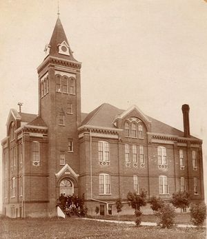
 Griggs County Courthouse. Photographed in 1892. | |
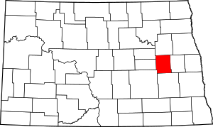
 الموقع ضمن ولاية North Dakota | |
 موقع North Dakota ضمن الولايات المتحدة | |
| الإحداثيات: 47°28′N 98°14′W / 47.46°N 98.23°W | |
| البلد | |
| State | |
| تأسست | February 18, 1881 (created) June 16, 1882 (organized) |
| Seat | Cooperstown |
| أكبر مدينة | Cooperstown |
| المساحة | |
| • الإجمالي | 716 ميل² (1٬850 كم²) |
| • البر | 709 ميل² (1٬840 كم²) |
| • الماء | 7٫6 ميل² (20 كم²) 1.1%% |
| التعداد | |
| • Estimate (2018) | 2٬232 |
| • الكثافة | 3٫18/sq mi (1٫23/km2) |
| منطقة التوقيت | UTC−6 (Central) |
| • الصيف (التوقيت الصيفي) | UTC−5 (CDT) |
| Congressional district | At-large |
| الموقع الإلكتروني | www |
گريگز إنگليزية: Griggs هي إحدى مقاطعات ولاية داكوتا الشمالية في الولايات المتحدة الأمريكية.
التجمعات
المدن
- Cooperstown (county seat)
- Binford
- Hannaford
Census-designated places
Unincorporated communities[1]
- Karnak
- Walum
البلديات
Politics
Griggs County voters usually vote Republican. In only one national election since 1964 has the county selected the Democratic Party candidate.
Presidential election results
| Year | Republican | Democratic | Third parties |
|---|---|---|---|
| 2016 | 67.0% 847 | 23.6% 298 | 9.5% 120 |
| 2012 | 57.4% 771 | 39.9% 536 | 2.7% 36 |
| 2008 | 51.9% 682 | 45.5% 598 | 2.6% 34 |
| 2004 | 63.0% 907 | 35.1% 505 | 1.9% 27 |
| 2000 | 62.6% 920 | 33.0% 484 | 4.4% 65 |
| 1996 | 46.5% 731 | 42.7% 670 | 10.8% 170 |
| 1992 | 44.0% 773 | 36.9% 647 | 19.1% 336 |
| 1988 | 54.1% 1,020 | 44.9% 846 | 1.0% 19 |
| 1984 | 59.9% 1,254 | 39.5% 828 | 0.6% 12 |
| 1980 | 61.8% 1,342 | 29.3% 636 | 8.9% 192 |
| 1976 | 48.0% 1,086 | 49.6% 1,122 | 2.4% 54 |
| 1972 | 58.1% 1,312 | 39.9% 901 | 2.0% 45 |
| 1968 | 49.8% 1,110 | 45.3% 1,008 | 4.9% 109 |
| 1964 | 37.0% 885 | 63.0% 1,505 | |
| 1960 | 49.9% 1,278 | 49.9% 1,279 | 0.2% 4 |
| 1956 | 50.8% 1,212 | 49.1% 1,173 | 0.1% 2 |
| 1952 | 66.2% 1,727 | 33.4% 872 | 0.4% 10 |
| 1948 | 44.3% 1,036 | 50.5% 1,180 | 5.2% 122 |
| 1944 | 44.5% 990 | 55.1% 1,228 | 0.4% 9 |
| 1940 | 43.1% 1,117 | 56.5% 1,464 | 0.4% 11 |
| 1936 | 24.5% 666 | 61.2% 1,665 | 14.4% 392 |
| 1932 | 18.0% 428 | 77.3% 1,838 | 4.7% 111 |
| 1928 | 52.5% 1,329 | 46.7% 1,182 | 0.9% 23 |
| 1924 | 33.3% 738 | 5.2% 116 | 61.4% 1,360 |
| 1920 | 73.8% 1,739 | 22.5% 530 | 3.7% 86 |
| 1916 | 40.9% 521 | 52.4% 668 | 6.8% 86 |
| 1912 | 14.5% 144 | 43.6% 434 | 41.9% 417 |
| 1908 | 51.8% 605 | 42.3% 493 | 5.9% 69 |
| 1904 | 66.8% 688 | 22.5% 232 | 10.7% 110 |
| 1900 | 54.4% 527 | 42.1% 407 | 3.5% 34 |
See also
- National Register of Historic Places listings in Griggs County, North Dakota
- USS Griggs (APA-110), U.S. Navy ship named for this county
References
- ^ خطأ استشهاد: وسم
<ref>غير صحيح؛ لا نص تم توفيره للمراجع المسماةGCND - ^ Leip, David. "Atlas of US Presidential Elections". uselectionatlas.org. Retrieved April 12, 2018.
{{cite web}}: Italic or bold markup not allowed in:|website=(help)

|
Nelson County | Eddy County | 
| |
| Steele County | Foster County | |||
| Barnes County | Stutsman County |
?
تصنيفات:
- CS1 errors: markup
- Pages using gadget WikiMiniAtlas
- Short description is different from Wikidata
- مقاطعات North Dakota
- Articles containing إنگليزية-language text
- Pages using Lang-xx templates
- Coordinates on Wikidata
- مقاطعة گريگز، داكوتا الشمالية
- تأسيسات 1882 في إقليم داكوتا
- أماكن مأهولة تأسست في 1882
- مقاطعات داكوتا الشمالية
