أرض متحاتة


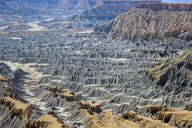
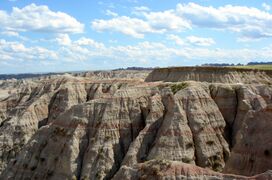
التربة المتحاتة Badlands مناطق ذات تلال منحدرة وأخاديد عميقة تكوَّنت أساسًا من التعرية بفعل المياه. تنتج الفيضانات المحدودة النطاق معظم عوامل التعرية في مناطق واسعة، وتتكوَّن التربة المتحاتة أيضًا بفعل التعرية الناتجة من قنوات المياه الصغيرة ومن قطرات مياه الأمطار المنهمرة على سفوح الجبال.
في حالات عدة يتكوَّن صخر الأساس ـ الأديم ـ في التربة المتحاتة من طبقات صخرية سميكة ولكنها غير قوية، وتكون التربة في هذه الأراضي ضعيفة البنية والتكوين أو منعدمة تماماً. ولذلك تستخدم هذه الأراضي عامة لرعي الماشية وموطنًا للحياة البرية أو مناظر طبيعية.
تتكوَّن هذه التربة طبيعيًا وفي مناخ جاف أو شبه جاف حيث تكثُر الفيضانات المحدودة النطاق الناتجة عن العواصف الرعدية، وقد تتكون أيضًا نتيجة للزراعة الرديئة أو نتيجة إتلاف محاصيل زراعية بطرق أخرى.
طبوغرافيا الأرض المتحاتة
Badlands are characterized by a distinctive badlands topography.[1][2] This is terrain in which water erosion has cut a very large number of deep drainage channels, separated by short, steep ridges (interfluves).[3] Such a drainage system is said to have a very fine drainage texture,[4] as measured by its drainage density. Drainage density is defined as the total length of drainage channels per unit area of land surface. Badlands have a very high drainage density of 77 to 747 miles per square mile (48 to 464 kilometers per square kilometer).[3] The numerous deep drainage channels and high interfluves creates a stark landscape of hills, gullies, and ravines.[1]
In addition to a dense system of drainages and interfluves, badlands often contain buttes and hoodoos ("mushroom rocks"). These are formed by resistant beds of sandstone, which form the caprock of the buttes and hoodoos.[2]
الأصل
Badlands arise from a combination of an impermeable but easily eroded ground surface, sparse vegetation, and infrequent but heavy rainfall.[4] The surface bedrock is typically mudrock, sometimes with evaporites, with only occasional beds of more resistant sandstone.[3] Infrequent heavy rains lead to heavy erosional dissection. Where sudden precipitation cannot penetrate impermeable clays, it is channeled into a very dense system of streamlets that erode a dense system of ever-enlarging, coalescing gulleys and ravines. Erosion is enhanced by pelting raindrops that dislodge soft sediments. The presence of bentonite clay further increases erodability, as can rejuvenation of the drainage system from regional uplift, as occurred at Badlands National Park.[2]
In addition to surface erosion, badlands sometimes have well-developed piping, which is a system of pipes, joints, caverns, and other connected void spaces in the subsurface through which water can drain. However, this is not a universal feature of badlands. For example, the Henry Mountains badlands show very little piping.[5]
The precise processes by which the erosion responses take place vary depending on the precise interbedding of the sedimentary material.[6] However, it has been estimated that the badlands of Badlands National Park erode at the relatively high rate of about واحد بوصة أو 25 ميليمتر per year.[7] The White River draining Badlands National Park was so named for its heavy load of bentonite clay eroded from the badlands.[2]
ريگوليث
Badlands are partially characterized by their thin to nonexistent regolith layers. The regolith profiles of badlands in arid climates are likely to resemble one another. In these regions, the upper layer (~1–5 cm أو 0.4–2.0 in) is typically composed of silt, shale, and sand (a byproduct of the weathered shale). This layer can form either a compact crust or a looser, more irregular aggregation of "popcorn" fragments. Located beneath the top layer is a sublayer (~5–10 cm أو 2.0–3.9 in), below which can be found a transitional shard layer (~10–40 cm أو 3.9–15.7 in), formed largely of loose disaggregated shale chips, which in turn eventually gives way to a layer of unweathered shale. Badlands such as those found in the Mancos Shale, the Brule Formation, the Chadron Formation, and the Dinosaur Provincial Park can be generally said to fit this profile.[5]
In less arid regions, the regolith profile can vary considerably. Some badlands have no regolith layer whatsoever, capping instead in bare rock such as sandstone. Others have a regolith with a clay veneer, and still others have a biological crust of algae or lichens.[5]
In addition to lacking significant regolith, they also lack much vegetation. The lack of vegetation could very well be a result of the lack of a substantial regolith.[8]
الأرض المتحاتة بشرياً
Although most badland topography is natural, badlands have been produced artificially by destruction of vegetation cover, through overgrazing, acid rain, or acid mine drainage.[3] An example of badlands created by mining is the Roman gold mine of Las Médulas in northern Spain.[بحاجة لمصدر] The Cheltenham Badlands in Caledon, Ontario, is an example of badlands produced by poor farming practices.[بحاجة لمصدر]
أصل الاسم
The word badlands is a calque from the Canadian French phrase les mauvaises terres, as the early French fur traders called the White River badlands les mauvaises terres à traverser or 'bad lands to traverse', perhaps influenced by the Lakota people who moved there in the late 1700s and who referred to the terrain as mako sica, meaning 'bad land' or 'eroded land'.[9]
The term malpaís means 'badlands' in Spanish,[10] but refers to a terrain of lava flows that is unlike the eroded badlands of the White River.[11]
الوقع البشري
Badlands are generally unsuitable for agriculture, but attempts have been made to remediate badlands. For example, reforestation is being attempted in the Garhbeta, Eastern India, badlands[12] Revegetation and reforestation have been studied in the black marl badlands of the French Alps. Austrian black pine can become established and then be gradually replaced by native deciduous species. However, the time scale for this process is many decades.[13]
المواقع

Badlands are found on all the continents except Antarctica. The presence of unconsolidated sediments is a strong control on their locations.[14]
الأجنتين
The Valle de la Luna ("Valley of the Moon") is one of many examples of badland formations in midwestern Argentina.[15]
كندا

The Cheltenham Badlands are in Caledon, Ontario, not far from the largest city Toronto.[16]
The Big Muddy Badlands in Saskatchewan[17] gained notoriety as a hideout for outlaws.[18]
There is a large badland area in Alberta, particularly in the valley of the Red Deer River, where Dinosaur Provincial Park is located, as well as in Drumheller, where the Royal Tyrrell Museum of Palaeontology is located.[19]
الهند
Garhbeta, Eastern India is a badlands located in a monsoon climate.[12] Chambal[20] spread across northern parts of Madhya Pradesh, southeastern Rajasthan and Southern parts of Uttar Pradesh known for its lawlessness and dacoity is another example of badlands. Small strip of badlands is also found in Western Uttar Pradesh and Haryana
إيطاليا

In Italy, badlands are called "calanchi". Some examples are Aliano (Basilicata), Crete Senesi (Tuscany) and Civita di Bagnoregio (Lazio).
نيوزيلندا
A well-known badlands formation in New Zealand – the Putangirua Pinnacles, formed by the erosion of the conglomerate of an old alluvial fan – is located at the head of a small valley near the southern tip of the North Island.[21][22]
إسپانيا

The Bardenas Reales near Tudela, Navarre, the Tabernas Desert in Tabernas, Almería, parts of the Granada Altiplano near Guadix and possibly Los Monegros in Aragon are examples of Spanish badlands.
تركيا
Turkey has extensive badlands,[14] including Göreme National Park.[23]
الولايات المتحدة

In the U.S., Makoshika State Park in Montana and Badlands National Park in South Dakota are examples of extensive badland formations. Also located in this region is Theodore Roosevelt National Park, a United States National Park composed of three geographically separated areas of badlands in western North Dakota named after former U.S. President Theodore Roosevelt. Petrified Forest National Park in Arizona which is part of Navajo County encompasses numerous badlands that also abuts the Navajo Indian Reservation and is directly north of Joseph City, Arizona. Many dinosaurs are believed to be buried in the immediate area and exploration has been ongoing since the early 20th century.[24]
Among the Henry Mountains area in Utah, about 4،900 ft (1،500 m) above sea level, Cretaceous- and Jurassic-aged shales are exposed.[5] Another popular area of badland formations is Toadstool Geologic Park in the Oglala National Grassland located in northwestern Nebraska. Dinosaur National Monument in Colorado and Utah are also badlands settings, along with several other areas in southern Utah, such as the Chinle Badlands in Grand Staircase–Escalante National Monument. A small badland called Hell's Half-Acre is present in Natrona County, Wyoming. Additional badlands also exist in various places throughout southwest Wyoming, such as near Pinedale and in the Bridger Valley near the towns of Lyman and Mountain View, near the high Uintah Mountains. Pinnacles National Park in California also has areas of badlands, as does the Mojave Desert in eastern California.
الثقافة والإعلام
Badlands have become a popular trope inside various different media, particularly westerns.[25]
معرض صور
-
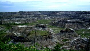 Badlands near Drumheller, Alberta
 -
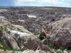 Badlands of Hell's Half-Acre, Natrona County, Wyoming
 -
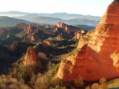 Panoramic view of Las Médulas, Spain
 -
-
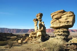
 Badlands incised into shale at the foot of the North Caineville Plateau, Utah, within the pass carved by the Fremont River known as the Blue Gate
 -
-
 Badlands in eastern Montana (Hell Creek Formation)


انظر أيضاً
- Earth forest
- Tsingy de Bemaraha Strict Nature Reserve
- Calanque
- Death Valley
- Malpaís (landform)
- تعرية
- مورفولوجيا أرضية
- Badlands Guardian
الهامش
- ^ أ ب Lillie, Robert J. (2005). Parks and plates : the geology of our national parks, monuments, and seashores (1st ed.). New York: W.W. Norton. p. 267. ISBN 0393924076.
- ^ أ ب ت ث Levin, Harold L. (2010). The earth through time (9th ed.). Hoboken, N.J.: J. Wiley. p. 475. ISBN 978-0470387740.
- ^ أ ب ت ث Jackson, Julia A., ed. (1997). "badlands". Glossary of geology (Fourth ed.). Alexandria, Virginia: American Geological Institute. ISBN 0922152349.
- ^ أ ب Thornbury, William D. (1969). Principles of geomorphology (2d ed.). New York: Wiley. p. 127. ISBN 0471861979.
- ^ أ ب ت ث خطأ استشهاد: وسم
<ref>غير صحيح؛ لا نص تم توفيره للمراجع المسماةA.D. Abrahams, Editors 2009 - ^ Thomas, D., ed. (2011). Arid zone geomorphology : process, form and change in drylands (3rd ed.). Chichester, West Sussex: Wiley-Blackwell. ISBN 978-0470519097.
- ^ "Geologic Formations: How Badlands Buttes Came to Be". National Park Service. 10 November 2020.
- ^ Bryan, R. and A. Yair, 1982a. Perspectives on studies of badland geomorphology. In Badland geomorphology and piping. R. Bryan and A. Yair (eds), 1-3. Norwich: Geo Books.
- ^ Shaw, Ethan (2018-03-18). "How Did Badlands National Park Get Its Name?". USA Today. Retrieved 2019-08-01.
- ^ "Frequently asked questions". El Malpais National Monument. National Park Service. Retrieved 18 January 2021.
- ^ Jackson, Julia A., ed. (1997). "Malpais". Glossary of geology (Fourth ed.). Alexandria, Virginia: American Geological Institute. ISBN 0922152349.
- ^ أ ب Saha, Asish; Pal, Subodh Chandra; Arabameri, Alireza; Chowdhuri, Indrajit; Rezaie, Fatemeh; Chakrabortty, Rabin; Roy, Paramita; Shit, Manisa (June 2021). "Optimization modelling to establish false measures implemented with ex-situ plant species to control gully erosion in a monsoon-dominated region with novel in-situ measurements". Journal of Environmental Management. 287: 112284. doi:10.1016/j.jenvman.2021.112284. PMID 33711662. S2CID 232217656.
- ^ Gallart, Francesc; Marignani, Michela; Pérez-Gallego, Nuria; Santi, Elisa; Maccherini, Simona (July 2013). "Thirty years of studies on badlands, from physical to vegetational approaches. A succinct review". CATENA. 106: 4–11. Bibcode:2013Caten.106....4G. doi:10.1016/j.catena.2012.02.008.
- ^ أ ب Avcioglu, Aydogan; Gorum, Tolga; Akbas, Abdullah; Moreno de las Heras, Mariano; Yetemen, Omer (2021). "The climatic, topographic and litho-tectonic characteristics of badlands in Turkey". EGU General Assembly Conference Abstracts. Bibcode:2021EGUGA..23.7788A. doi:10.5194/egusphere-egu21-7788. S2CID 236762970.
{{cite journal}}: CS1 maint: unflagged free DOI (link) - ^ "Ischigualasto / Talampaya Natural Parks". UNESCO World Heritage Centre.
- ^ Kasanin-Grubin, Milica (2013-07-01). "Clay mineralogy as a crucial factor in badland hillslope processes". CATENA. Updating Badlands Research (in الإنجليزية). 106: 54–67. Bibcode:2013Caten.106...54K. doi:10.1016/j.catena.2012.08.008. ISSN 0341-8162.
- ^ Harel, Claude-Jean (2006). "Big Muddy Valley". Encyclopedia of Saskatchewan. Great Plains Research Center. Archived from the original on 2009-06-19. Retrieved 2010-05-11.
- ^ Yanko, Dave. "Outlaw Rule". Virtual Saskatchewan. Retrieved 2010-05-11.
- ^ Currie, P.J.; Koppelhus, E.B., eds. (2005). Dinosaur Provincial Park : a spectacular ancient ecosystem revealed. Bloomington: Indiana University Press. ISBN 9780253345950.
- ^ "28/07/2020". Empower IAS. Retrieved 2022-09-05.
- ^ "Putangirua Pinnacles Scenic Reserve". www.doc.govt.nz.
- ^ Lloyd Homer and Phil Moore, "Reading the Rocks: Aguide to the Geological Features of the Wairarapa Coast", Landscape Publications limited, 1989
- ^ Ertek, T. Ahmet (12 March 2021). "The Geoheritage of Göreme National Park and the Rock Sites of Cappadocia, Turkey". Zeitschrift für Geomorphologie, Supplementary Issues. 62 (3): 333–348. Bibcode:2021ZGmS...62..333E. doi:10.1127/zfg_suppl/2021/0702. S2CID 233709481.
- ^ Ash, Sidney (2005). Petrified Forest: A Story in Stone (2nd rev. ed.). Petrified Forest National Park, Arizona: Petrified Forest Museum Association. ISBN 978-0-945695-11-0.
- ^ Río, David (2016). "Facing Old Age and Searching for Regeneration in a Dying American West: Gregory Martin's "Mountain City" / Afrontando la vejez y buscando la regeneración en un Oeste norteamericano moribundo: "Mountain City", de Gregory Martin" (PDF). Atlantis. 38 (1): 149–164. JSTOR 24757762.
وصلات خارجية

- Badlands National Park (U.S. National Park Service)
- The Badlands: Nature's Time Capsule – Documentary about the badlands of South Dakota.
 "Bad Lands". New International Encyclopedia. {{{year}}}.