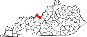
مقاطعة ميد، كنتكي
Meade County | |
|---|---|
 Meade County courthouse in Brandenburg | |
 الموقع ضمن ولاية Kentucky | |
 موقع Kentucky ضمن الولايات المتحدة | |
| الإحداثيات: 37°59′N 86°13′W / 37.98°N 86.22°W | |
| البلد | |
| State | |
| تأسست | 1823 |
| السمِيْ | James Meade |
| Seat | Brandenburg |
| أكبر مدينة | Brandenburg |
| المساحة | |
| • الإجمالي | 325 ميل² (840 كم²) |
| • البر | 305 ميل² (790 كم²) |
| • الماء | 19 ميل² (50 كم²) 5.9%% |
| التعداد | |
| • Estimate (2018) | 28٬715 |
| • الكثافة | 94/sq mi (36/km2) |
| منطقة التوقيت | UTC−5 (Eastern) |
| • الصيف (التوقيت الصيفي) | UTC−4 (EDT) |
| Congressional district | 2nd |
| الموقع الإلكتروني | www |
مقاطعة ميد إنگليزية: Meade County هي إحدى المقاطعات في ولاية كنتكي في الولايات المتحدة.
الديمغرافيا
| التعداد | Pop. | ملاحظة | %± |
|---|---|---|---|
| 1830 | 4٬131 | — | |
| 1840 | 5٬780 | 39٫9% | |
| 1850 | 7٬393 | 27٫9% | |
| 1860 | 8٬898 | 20٫4% | |
| 1870 | 9٬485 | 6٫6% | |
| 1880 | 10٬323 | 8٫8% | |
| 1890 | 9٬484 | −8٫1% | |
| 1900 | 10٬533 | 11٫1% | |
| 1910 | 9٬783 | −7٫1% | |
| 1920 | 9٬442 | −3٫5% | |
| 1930 | 8٬042 | −14٫8% | |
| 1940 | 8٬827 | 9٫8% | |
| 1950 | 9٬422 | 6٫7% | |
| 1960 | 18٬938 | 101�0% | |
| 1970 | 18٬796 | −0٫7% | |
| 1980 | 22٬854 | 21٫6% | |
| 1990 | 24٬170 | 5٫8% | |
| 2000 | 26٬349 | 9�0% | |
| 2010 | 28٬602 | 8٫6% | |
| 2018 (تق.) | 28٬715 | [1] | 0٫4% |
| U.S. Decennial Census[2] 1790–1960[3] 1900–1990[4] 1990–2000[5] 2010–2013[6] | |||
السياسة
Presidential elections results
| Year | Republican | Democratic | Third parties |
|---|---|---|---|
| 2016 | 70.8% 8,660 | 24.7% 3,026 | 4.5% 545 |
| 2012 | 60.5% 6,606 | 37.8% 4,122 | 1.7% 188 |
| 2008 | 59.7% 6,691 | 38.8% 4,343 | 1.5% 172 |
| 2004 | 65.3% 7,152 | 34.0% 3,724 | 0.7% 75 |
| 2000 | 58.6% 5,319 | 39.6% 3,596 | 1.7% 156 |
| 1996 | 38.3% 2,855 | 49.0% 3,653 | 12.6% 941 |
| 1992 | 35.9% 2,641 | 46.0% 3,387 | 18.2% 1,337 |
| 1988 | 52.6% 3,441 | 47.0% 3,079 | 0.4% 25 |
| 1984 | 60.2% 3,820 | 39.4% 2,503 | 0.4% 24 |
| 1980 | 45.2% 2,740 | 52.9% 3,205 | 1.9% 114 |
| 1976 | 36.1% 1,755 | 62.2% 3,030 | 1.7% 83 |
| 1972 | 60.9% 2,492 | 37.7% 1,541 | 1.4% 57 |
| 1968 | 33.0% 1,385 | 45.9% 1,926 | 21.2% 889 |
| 1964 | 25.5% 1,055 | 74.4% 3,076 | 0.1% 5 |
| 1960 | 43.4% 1,826 | 56.6% 2,385 | 0.0% 0 |
| 1956 | 45.2% 1,670 | 54.6% 2,016 | 0.2% 6 |
| 1952 | 38.2% 1,265 | 61.6% 2,040 | 0.2% 5 |
| 1948 | 28.0% 773 | 69.3% 1,915 | 2.7% 74 |
| 1944 | 36.1% 1,040 | 63.5% 1,828 | 0.4% 12 |
| 1940 | 31.9% 995 | 67.7% 2,114 | 0.4% 12 |
| 1936 | 26.5% 785 | 70.9% 2,102 | 2.7% 79 |
| 1932 | 29.5% 1,050 | 69.8% 2,488 | 0.7% 26 |
| 1928 | 48.5% 1,610 | 51.3% 1,700 | 0.2% 7 |
| 1924 | 37.4% 1,106 | 61.0% 1,802 | 1.6% 47 |
| 1920 | 39.8% 1,468 | 59.4% 2,195 | 0.8% 30 |
| 1916 | 37.1% 803 | 60.9% 1,317 | 2.0% 44 |
| 1912 | 16.6% 337 | 56.4% 1,145 | 27.1% 550 |
انظر أيضاً
الهامش
- ^ "Population and Housing Unit Estimates". Retrieved July 29, 2019.
- ^ "U.S. Decennial Census". United States Census Bureau. Retrieved August 17, 2014.
- ^ "Historical Census Browser". University of Virginia Library. Retrieved August 17, 2014.
- ^ "Population of Counties by Decennial Census: 1900 to 1990". United States Census Bureau. Retrieved August 17, 2014.
- ^ "Census 2000 PHC-T-4. Ranking Tables for Counties: 1990 and 2000" (PDF). United States Census Bureau. Retrieved August 17, 2014.
- ^ خطأ استشهاد: وسم
<ref>غير صحيح؛ لا نص تم توفيره للمراجع المسماةQF - ^ Leip, David. "Dave Leip's Atlas of U.S. Presidential Elections". uselectionatlas.org. Retrieved 2018-07-04.
وصلات خارجية
- "Ky-313 extension is well under way"—The News-Enterprise, July 24, 2011
- Meade County Fiscal Court & Meade County Tourism
- Meade County Chamber of Commerce
الكلمات الدالة:
?
تصنيفات:
- Pages using gadget WikiMiniAtlas
- Short description is different from Wikidata
- Coordinates on Wikidata
- مقاطعات Kentucky
- Articles containing إنگليزية-language text
- Pages using Lang-xx templates
- Pages using US Census population needing update
- مقاطعة ميد، كنتكي
- تأسيسات 1823 في كنتكي
- مقاطعات كنتكي على نهر أوهايو
- Louisville metropolitan area
- أماكن مأهولة تأسست في 1823
- مقاطعات كنتكي