مقاطعة بويد، كنتكي
Boyd County | |
|---|---|
County | |
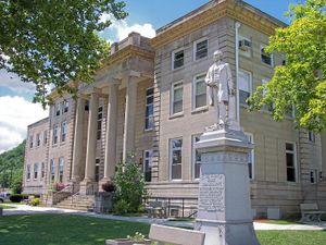
 The Boyd County Courthouse in Catlettsburg, with a statue of John Milton Elliott | |
| الشعار: Unity and Progress | |
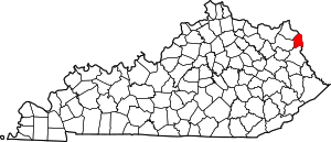
 الموقع ضمن ولاية Kentucky | |
 موقع Kentucky ضمن الولايات المتحدة | |
| الإحداثيات: 38°22′N 82°41′W / 38.36°N 82.69°W | |
| البلد | |
| State | |
| تأسست | 1860 |
| السمِيْ | Linn Boyd |
| Seat | Catlettsburg |
| أكبر مدينة | Ashland |
| المساحة | |
| • الإجمالي | 162 ميل² (420 كم²) |
| • البر | 160 ميل² (400 كم²) |
| • الماء | 2٫2 ميل² (6 كم²) 1.3%% |
| التعداد | |
| • Estimate (2018) | 47٬240 |
| • الكثافة | 310/sq mi (120/km2) |
| منطقة التوقيت | UTC−5 (Eastern) |
| • الصيف (التوقيت الصيفي) | UTC−4 (EDT) |
| Congressional districts | 4th، 5th |
| الموقع الإلكتروني | boydcountyky |
مقاطعة بويد إنگليزية: Boyd County هي إحدى المقاطعات في ولاية كنتاكي في الولايات المتحدة.
الجغرافيا
According to the U.S. Census Bureau, the county has a total area of 162 ميل مربع (420 km2), of which 160 ميل مربع (410 km2) is land and 2.2 ميل مربع (5.7 km2) (1.3%) is water.[1]
المقاطعات المجاورة
- Greenup County (northwest)
- Lawrence County, Ohio (northeast)
- Wayne County, West Virginia (east)
- Lawrence County (south)
- Carter County (west)
السكان
| التعداد | Pop. | ملاحظة | %± |
|---|---|---|---|
| 1870 | 8٬573 | — | |
| 1880 | 12٬165 | 41٫9% | |
| 1890 | 14٬033 | 15٫4% | |
| 1900 | 18٬834 | 34٫2% | |
| 1910 | 23٬444 | 24٫5% | |
| 1920 | 29٬281 | 24٫9% | |
| 1930 | 43٬849 | 49٫8% | |
| 1940 | 45٬938 | 4٫8% | |
| 1950 | 49٬949 | 8٫7% | |
| 1960 | 52٬163 | 4٫4% | |
| 1970 | 52٬376 | 0٫4% | |
| 1980 | 55٬513 | 6�0% | |
| 1990 | 51٬150 | −7٫9% | |
| 2000 | 49٬752 | −2٫7% | |
| 2010 | 49٬542 | −0٫4% | |
| 2018 (تق.) | 47٬240 | [2] | −4٫6% |
| U.S. Decennial Census[3] 1790-1960[4] 1900-1990[5] 1990-2000[6] 2010-2013[7] | |||
Politics
Voter Registration
#3333FF #E81B23 #DDDDBB #DDDDBB #FED105 #17aa5c #A356DE| Boyd County Voter Registration & Party Enrollment as of February 17, 2020[8] | |||||
|---|---|---|---|---|---|
| Political Party | Total Voters | Percentage | |||
| Democratic | 20,542 | 50.85% | |||
| Republican | 16,144 | 39.96% | |||
| Independent | 2,031 | 5.03% | |||
| Others | 1,529 | 3.78% | |||
| Libertarian | 128 | 0.32% | |||
| Green | 17 | 0.04% | |||
| Constitution | 8 | 0.02% | |||
| Total | 40,399 | 100% | |||
Presidential elections results
| Year | Republican | Democratic | Third parties |
|---|---|---|---|
| 2016 | 66.5% 13,591 | 29.4% 6,021 | 4.1% 842 |
| 2012 | 57.1% 10,884 | 40.8% 7,776 | 2.0% 389 |
| 2008 | 55.3% 11,430 | 43.0% 8,886 | 1.7% 354 |
| 2004 | 52.8% 11,501 | 46.5% 10,132 | 0.7% 144 |
| 2000 | 48.2% 9,247 | 49.7% 9,541 | 2.1% 394 |
| 1996 | 37.3% 7,054 | 51.2% 9,668 | 11.5% 2,171 |
| 1992 | 34.9% 7,387 | 49.6% 10,496 | 15.4% 3,264 |
| 1988 | 49.4% 9,379 | 50.3% 9,552 | 0.3% 57 |
| 1984 | 53.0% 10,925 | 46.6% 9,601 | 0.5% 95 |
| 1980 | 47.8% 10,367 | 49.3% 10,702 | 2.9% 626 |
| 1976 | 44.5% 9,106 | 54.5% 11,150 | 1.0% 203 |
| 1972 | 65.9% 12,812 | 33.1% 6,434 | 1.0% 191 |
| 1968 | 45.4% 8,632 | 41.7% 7,914 | 12.9% 2,455 |
| 1964 | 37.7% 6,941 | 62.0% 11,436 | 0.3% 60 |
| 1960 | 55.4% 11,305 | 44.6% 9,094 | 0.0% 0 |
| 1956 | 57.3% 11,502 | 42.6% 8,546 | 0.2% 34 |
| 1952 | 50.3% 10,426 | 49.4% 10,245 | 0.2% 49 |
| 1948 | 42.0% 6,707 | 56.4% 9,006 | 1.6% 262 |
| 1944 | 45.7% 6,868 | 54.1% 8,130 | 0.3% 42 |
| 1940 | 42.4% 7,322 | 57.2% 9,868 | 0.4% 75 |
| 1936 | 40.3% 6,650 | 59.2% 9,762 | 0.5% 80 |
| 1932 | 44.7% 6,853 | 54.2% 8,315 | 1.1% 175 |
| 1928 | 66.4% 9,118 | 33.6% 4,611 | 0.1% 7 |
| 1924 | 55.6% 6,062 | 37.4% 4,079 | 7.1% 772 |
| 1920 | 54.8% 6,334 | 44.1% 5,103 | 1.1% 126 |
| 1916 | 50.2% 2,883 | 47.7% 2,738 | 2.1% 122 |
| 1912 | 28.1% 1,271 | 39.2% 1,772 | 32.7% 1,478 |
Education
Colleges
Ashland Community and Technical College, in Ashland, is one of 16 two-year, open-admissions colleges of the Kentucky Community and Technical College System. Morehead State University also has a satellite campus located in Ashland.
Communities
Cities
- Ashland
- Catlettsburg (county seat)
Census-designated places
Unincorporated communities
انظر أيضاً
- Ashland Commercial Historic District
- Catlett House
- National Register of Historic Places listings in Boyd County, Kentucky
الهامش
- ^ "2010 Census Gazetteer Files". United States Census Bureau. August 22, 2012. Archived from the original on August 12, 2014. Retrieved August 12, 2014.
- ^ "Population and Housing Unit Estimates". Retrieved July 26, 2019.
- ^ "U.S. Decennial Census". United States Census Bureau. Retrieved August 12, 2014.
- ^ "Historical Census Browser". University of Virginia Library. Retrieved August 12, 2014.
- ^ "Population of Counties by Decennial Census: 1900 to 1990". United States Census Bureau. Retrieved August 12, 2014.
- ^ "Census 2000 PHC-T-4. Ranking Tables for Counties: 1990 and 2000" (PDF). United States Census Bureau. Retrieved August 12, 2014.
- ^ خطأ استشهاد: وسم
<ref>غير صحيح؛ لا نص تم توفيره للمراجع المسماةQF - ^ "Archived copy" (PDF). Archived from the original (PDF) on 2014-11-26. Retrieved 2020-03-14.
{{cite web}}: CS1 maint: archived copy as title (link) - ^ Leip, David. "Dave Leip's Atlas of U.S. Presidential Elections". uselectionatlas.org. Retrieved 2018-06-29.
وصلات خارجية
قالب:Boyd County, Kentucky قالب:Huntington-Ashland-Ironton MSA قالب:Eastern Mountain Coal Fields (Kentucky)
الكلمات الدالة:
?
تصنيفات:
- Pages using gadget WikiMiniAtlas
- Short description is different from Wikidata
- Coordinates on Wikidata
- مقاطعات Kentucky
- Articles containing إنگليزية-language text
- Pages using Lang-xx templates
- Pages using US Census population needing update
- مقاطعة بويد، كنتكي
- مقاطعات أپالاشيا
- مقاطعات كنتكي على نهر أوهايو
- تأسيسات 1860 في كنتكي
- أماكن مأهولة تأسست في 1860
- مقاطعات كنتكي