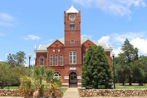
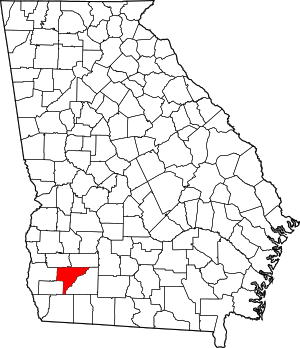
مقاطعة بيكر، جورجيا
Baker County | |
|---|---|
 | |
 الموقع ضمن ولاية Georgia | |
 موقع Georgia ضمن الولايات المتحدة | |
| الإحداثيات: 31°20′N 84°27′W / 31.33°N 84.45°W | |
| البلد | |
| State | |
| تأسست | 12 ديسمبر, 1825 |
| السمِيْ | جون بيكر |
| Seat | نيوتن |
| أكبر مدينة | نيوتن |
| المساحة | |
| • الإجمالي | 349 ميل² (900 كم²) |
| • البر | 342 ميل² (890 كم²) |
| • الماء | 7٫2 ميل² (19 كم²) 2.1%% |
| التعداد (2010) | |
| • الإجمالي | 3٬451 |
| • الكثافة | 10/sq mi (4/km2) |
| منطقة التوقيت | UTC−5 (Eastern) |
| • الصيف (التوقيت الصيفي) | UTC−4 (EDT) |
| Congressional district | 2nd |
مقاطعة باكر إنگليزية: Baker County هي إحدى المقاطعات في ولاية جورجيا في الولايات المتحدة الأمريكية.
المقاطعات المجاورة
- مقاطعة دُوَرتي، جورجيا - شمال شرق
- Mitchell County, Georgia - east
- Decatur County, Georgia - southwest
- Early County, Georgia - west
- Miller County, Georgia - west
- Calhoun County, Georgia - northwest
الديمغرافيا
| التعداد | Pop. | ملاحظة | %± |
|---|---|---|---|
| 1830 | 1٬253 | — | |
| 1840 | 4٬226 | 237٫3% | |
| 1850 | 8٬120 | 92٫1% | |
| 1860 | 4٬985 | −38٫6% | |
| 1870 | 6٬843 | 37٫3% | |
| 1880 | 7٬307 | 6٫8% | |
| 1890 | 6٬144 | −15٫9% | |
| 1900 | 6٬704 | 9٫1% | |
| 1910 | 7٬973 | 18٫9% | |
| 1920 | 8٬298 | 4٫1% | |
| 1930 | 7٬818 | −5٫8% | |
| 1940 | 7٬344 | −6٫1% | |
| 1950 | 5٬952 | −19�0% | |
| 1960 | 4٬543 | −23٫7% | |
| 1970 | 3٬875 | −14٫7% | |
| 1980 | 3٬808 | −1٫7% | |
| 1990 | 3٬615 | −5٫1% | |
| 2000 | 4٬074 | 12٫7% | |
| 2010 | 3٬451 | −15٫3% | |
| 2016 (تق.) | 3٬150 | [1] | −8٫7% |
| U.S. Decennial Census[2] 1790-1960[3] 1900-1990[4] 1990-2000[5] 2010-2013[6] | |||
السياسة
نتائج الانتخابات الرئاسية
| السنة | جمهوري | ديمقراطي | أحزاب ثالثة |
|---|---|---|---|
| 2016 | 53.8% 775 | 45.1% 650 | 1.0% 15 |
| 2012 | 49.3% 785 | 49.9% 794 | 0.8% 12 |
| 2008 | 49.0% 828 | 50.1% 846 | 0.9% 15 |
| 2004 | 46.5% 821 | 53.0% 936 | 0.5% 8 |
| 2000 | 40.5% 615 | 58.8% 893 | 0.7% 11 |
| 1996 | 27.7% 408 | 64.8% 955 | 7.6% 112 |
| 1992 | 26.6% 391 | 58.9% 864 | 14.5% 213 |
| 1988 | 46.7% 629 | 52.5% 707 | 0.9% 12 |
| 1984 | 49.4% 675 | 50.6% 691 | |
| 1980 | 32.6% 510 | 66.2% 1,035 | 1.2% 19 |
| 1976 | 20.8% 305 | 79.2% 1,162 | |
| 1972 | 73.7% 965 | 26.3% 345 | |
| 1968 | 5.8% 99 | 32.0% 548 | 62.3% 1,067 |
| 1964 | 60.3% 914 | 39.6% 600 | 0.1% 1 |
| 1960 | 8.4% 66 | 91.6% 720 | |
| 1956 | 3.9% 32 | 96.1% 783 | |
| 1952 | 13.4% 155 | 86.6% 1,005 | |
| 1948 | 2.5% 7 | 77.0% 218 | 20.5% 58 |
| 1944 | 6.1% 31 | 93.9% 478 | |
| 1940 | 5.1% 30 | 94.7% 557 | 0.2% 1 |
| 1936 | 2.1% 13 | 97.7% 599 | 0.2% 1 |
| 1932 | 0.3% 2 | 99.2% 647 | 0.5% 3 |
| 1928 | 17.7% 99 | 82.4% 462 | |
| 1924 | 7.7% 21 | 89.7% 245 | 2.6% 7 |
| 1920 | 36.2% 80 | 63.8% 141 | 0.0% 0 |
| 1916 | 17.8% 94 | 82.2% 435 | 0.0% 0 |
| 1912 | 2.7% 5 | 97.3% 183 | 0.0% 0 |
التجمعات
مدينة
التجمعات غير المشهرة
بلدات أشباح
Source:[8]
See also
الهامش
- ^ "Population and Housing Unit Estimates". Retrieved June 9, 2017.
- ^ "U.S. Decennial Census". United States Census Bureau. Archived from the original on May 12, 2015. Retrieved June 17, 2014.
{{cite web}}: Unknown parameter|deadurl=ignored (|url-status=suggested) (help) - ^ "Historical Census Browser". University of Virginia Library. Retrieved June 17, 2014.
- ^ "Population of Counties by Decennial Census: 1900 to 1990". United States Census Bureau. Retrieved June 17, 2014.
- ^ "Census 2000 PHC-T-4. Ranking Tables for Counties: 1990 and 2000" (PDF). United States Census Bureau. Retrieved June 17, 2014.
- ^ خطأ استشهاد: وسم
<ref>غير صحيح؛ لا نص تم توفيره للمراجع المسماةQF - ^ Leip, David. "Dave Leip's Atlas of U.S. Presidential Elections". uselectionatlas.org. Retrieved March 18, 2018.
- ^ Baker County Historical Society (1991). The History of Baker County. Newton, Baker County, Georgia, USA: Baker County Historical Society. pp. 54–69. LCCN 92080765.
وصلات خارجية
- Baker County Sheriff's Office
- Baker County historical marker

|
مقاطعة دُوَرتي | مقاطعة كالهون | 
| |
| مقاطعة متشل | مقاطعة إرلي و مقطعة ميلر | |||
| مقاطعة دكيتر |
الكلمات الدالة:
?
تصنيفات:
- CS1 errors: unsupported parameter
- Pages using gadget WikiMiniAtlas
- Short description is different from Wikidata
- Georgia (U.S. state) counties
- Articles containing إنگليزية-language text
- Pages using Lang-xx templates
- Pages using US Census population needing update
- Pages with empty portal template
- Coordinates on Wikidata
- مقاطعة بيكر، جورجيا
- تأسيسات 1825 في الولايات المتحدة
- أماكن مأهولة تأسست في 1825
- Albany, Georgia metropolitan area
- مقاطعات ولاية جورجيا
