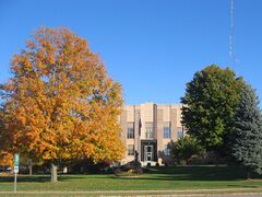
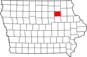
مقاطعة بريمر، آيوا
(تم التحويل من مقاطعة بريمير، آيوا)
Bremer County | |
|---|---|
 | |
 الموقع ضمن ولاية Iowa | |
 موقع Iowa ضمن الولايات المتحدة | |
| الإحداثيات: 42°46′27″N 92°19′01″W / 42.77417°N 92.31694°W | |
| البلد | |
| State | |
| تأسست | 1851 |
| السمِيْ | Fredrika Bremer |
| Seat | Waverly |
| أكبر مدينة | Waverly |
| المساحة | |
| • الإجمالي | 439 ميل² (1٬140 كم²) |
| • البر | 435 ميل² (1٬130 كم²) |
| • الماء | 3٫9 ميل² (10 كم²) 0.9% |
| التعداد (2020) | |
| • الإجمالي | 24٬988 |
| • الكثافة | 57/sq mi (22/km2) |
| منطقة التوقيت | UTC−6 (Central) |
| • الصيف (التوقيت الصيفي) | UTC−5 (CDT) |
| Congressional district | 1st |
| الموقع الإلكتروني | www |
مقاطعة بريمر إنگليزية: Bremer County [أ] هي إحدى مقاطعات ولاية آيوا في الولايات المتحدة.
المقاطعات المجاورة
- Chickasaw County (north)
- Fayette County (east)
- Floyd County (northwest)
- Black Hawk County (south)
- Buchanan County (southeast)
- Butler County (west)
الديمغرافيا
| التعداد | Pop. | ملاحظة | %± |
|---|---|---|---|
| 1860 | 4٬915 | — | |
| 1870 | 12٬528 | 154٫9% | |
| 1880 | 14٬081 | 12٫4% | |
| 1890 | 14٬630 | 3٫9% | |
| 1900 | 16٬305 | 11٫4% | |
| 1910 | 15٬843 | −2٫8% | |
| 1920 | 16٬728 | 5٫6% | |
| 1930 | 17٬046 | 1٫9% | |
| 1940 | 17٬932 | 5٫2% | |
| 1950 | 18٬884 | 5٫3% | |
| 1960 | 21٬108 | 11٫8% | |
| 1970 | 22٬737 | 7٫7% | |
| 1980 | 24٬820 | 9٫2% | |
| 1990 | 22٬813 | −8٫1% | |
| 2000 | 23٬325 | 2٫2% | |
| 2010 | 24٬276 | 4٫1% | |
| 2020 | 24٬988 | 2٫9% | |
| U.S. Decennial Census[2] 1790-1960[3] 1900-1990[4] 1990-2000[5] 2010-2018 | |||
ترتيب التعداد
The population ranking of the following table is based on the 2020 census of Bremer County.[6] † مقر المقاطعة
| الترتيب | المدينة/البلدة/إلخ. | النوع البلدي | التعداد (إحصاء 2020) |
|---|---|---|---|
| 1 | † ويڤرلي | مدينة | 10,394 |
| 2 | سمنر (partially in Fayette County) | مدينة | 2,030 |
| 3 | دنڤر | مدينة | 1,919 |
| 4 | تريپولي | مدينة | 1,191 |
| 5 | Janesville (partially in Black Hawk County) | مدينة | 1,034 |
| 6 | Readlyn | مدينة | 845 |
| 7 | Plainfield | مدينة | 393 |
| 8 | Frederika | مدينة | 204 |
السياسة
نتائج الانتخابات الرئاسية
| السنة | جمهوري | ديمقراطي | أحزاب ثالثة |
|---|---|---|---|
| 2020 | 57.0% 8,294 | 41.0% 5,958 | 2.0% 294 |
| 2016 | 53.2% 7,208 | 39.6% 5,356 | 7.2% 974 |
| 2012 | 48.0% 6,405 | 50.7% 6,763 | 1.3% 178 |
| 2008 | 44.6% 5,741 | 53.9% 6,940 | 1.5% 191 |
| 2004 | 52.2% 6,665 | 47.2% 6,025 | 0.7% 89 |
| 2000 | 50.8% 5,675 | 46.3% 5,169 | 3.0% 331 |
| 1996 | 41.4% 4,213 | 49.4% 5,023 | 9.2% 936 |
| 1992 | 38.3% 4,482 | 40.8% 4,774 | 21.0% 2,458 |
| 1988 | 50.3% 5,079 | 49.1% 4,961 | 0.6% 59 |
| 1984 | 62.4% 6,895 | 36.9% 4,084 | 0.7% 76 |
| 1980 | 59.3% 6,706 | 31.2% 3,527 | 9.6% 1,085 |
| 1976 | 58.5% 6,252 | 39.3% 4,203 | 2.2% 230 |
| 1972 | 65.9% 6,333 | 32.5% 3,122 | 1.6% 156 |
| 1968 | 65.8% 5,604 | 29.1% 2,481 | 5.1% 438 |
| 1964 | 43.4% 3,880 | 56.4% 5,045 | 0.2% 14 |
| 1960 | 66.8% 6,504 | 33.2% 3,234 | 0.0% 4 |
| 1956 | 67.2% 5,930 | 32.8% 2,892 | 0.1% 9 |
| 1952 | 74.1% 6,806 | 25.7% 2,363 | 0.2% 14 |
| 1948 | 51.6% 3,837 | 47.1% 3,502 | 1.3% 94 |
| 1944 | 63.6% 4,861 | 36.2% 2,764 | 0.2% 17 |
| 1940 | 63.3% 5,374 | 36.5% 3,103 | 0.2% 18 |
| 1936 | 38.0% 3,220 | 59.7% 5,058 | 2.3% 192 |
| 1932 | 31.5% 2,520 | 67.7% 5,411 | 0.8% 63 |
| 1928 | 55.1% 3,879 | 44.7% 3,146 | 0.3% 18 |
| 1924 | 48.3% 3,532 | 12.5% 911 | 39.2% 2,867 |
| 1920 | 86.5% 6,287 | 12.4% 902 | 1.1% 80 |
| 1916 | 69.8% 2,684 | 29.4% 1,132 | 0.8% 31 |
| 1912 | 26.9% 1,013 | 51.7% 1,944 | 21.5% 807 |
| 1908 | 45.3% 1,656 | 52.7% 1,925 | 2.1% 75 |
| 1904 | 50.8% 1,927 | 47.0% 1,783 | 2.2% 82 |
| 1900 | 52.5% 2,178 | 46.5% 1,929 | 1.1% 45 |
| 1896 | 54.0% 2,116 | 43.5% 1,704 | 2.5% 97 |
انظر أيضاً
ملاحظات
المراجع
- ^ Sherman, Barney (September 14, 2017). "Iowa Place Names: A-E". Iowa Public Radio. Retrieved June 9, 2021.
- ^ "U.S. Decennial Census". United States Census Bureau. Retrieved July 13, 2014.
- ^ "Historical Census Browser". University of Virginia Library. Retrieved July 13, 2014.
- ^ "Population of Counties by Decennial Census: 1900 to 1990". United States Census Bureau. Retrieved July 13, 2014.
- ^ "Census 2000 PHC-T-4. Ranking Tables for Counties: 1990 and 2000" (PDF). United States Census Bureau. Retrieved July 13, 2014.
- ^ خطأ استشهاد: وسم
<ref>غير صحيح؛ لا نص تم توفيره للمراجع المسماةcen2020 - ^ Leip, David. "Dave Leip's Atlas of U.S. Presidential Elections". uselectionatlas.org. Retrieved April 13, 2018.
وصلات خارجية
مشاع المعرفة فيه ميديا متعلقة بموضوع مقاطعة بريمر، آيوا.

|
Chickasaw County | Floyd County | 
| |
| Fayette County | Butler County | |||
| Buchanan County | Black Hawk County |
?
تصنيفات:
- Pages using gadget WikiMiniAtlas
- Short description is different from Wikidata
- Coordinates on Wikidata
- مقاطعات Iowa
- Pages using infobox U.S. county with unknown parameters
- Articles containing إنگليزية-language text
- Pages using Lang-xx templates
- Pages with empty portal template
- مقاطعة بريمر، آيوا
- Waterloo – Cedar Falls metropolitan area
- تأسيسات 1851 في آيوا
- أماكن مأهولة تأسست في 1851
- مقاطعات آيوا


