كلومبيا، كارولينا الجنوبية
Columbia, South Carolina | |
|---|---|
| City of Columbia | |
 | |
| الكنية: "Soda City"[1] | |
| الشعار: Justitia Virtutum Regina (Latin) "Justice, the Queen of Virtues" | |
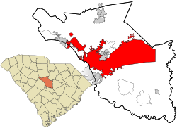 Location in Richland County and the state of South Carolina | |
| الإحداثيات: 34°0′2″N 81°2′5″W / 34.00056°N 81.03472°W | |
| Country | United States |
| State | South Carolina |
| County | Richland, Lexington |
| Approved | March 22, 1786 |
| Chartered (town) | 1805 |
| Chartered (city) | 1854 |
| السمِيْ | Columbia (personification) |
| الحكومة | |
| • Mayor | Stephen K. Benjamin (D) |
| المساحة | |
| • Total | 139٫64 ميل² (361٫68 كم²) |
| • البر | 136٫78 ميل² (354٫25 كم²) |
| • الماء | 2٫87 ميل² (7٫43 كم²) 2% |
| المنسوب | 292 ft (89 m) |
| التعداد (2020) | |
| • Total | 136٬632 |
| • الترتيب | SC: 2nd; US: 205th |
| • الكثافة | 962٫70/sq mi (371٫70/km2) |
| • Urban | 549٬777 (US: 75th) |
| • MSA (2020) | 829٬470 (US: 70th) |
| • CSA (2020) | 951٬412 (US: 60th) |
| منطقة التوقيت | UTC-5 (Eastern (EST)) |
| • الصيف (التوقيت الصيفي) | UTC-4 (EDT) |
| ZIP code(s) | 29201, 29203-6, 29209-10, 29212, 29223, 29225, 29229 |
| مفتاح الهاتف | 803, 839 |
| FIPS code | 45-16000 |
| GNIS feature ID | 1245051[3] |
| الموقع الإلكتروني | www |
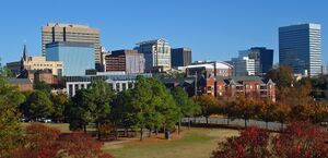
Columbia is the capital of the U.S. state of South Carolina. With a population of 136,632 as of the 2020 U.S. Census, it is the second-largest city in South Carolina.[4][5] The city serves as the county seat of Richland County, and a portion of the city extends into neighboring Lexington County. It is the center of the Columbia metropolitan statistical area, which had a population of 829,470 and is the 72nd-largest metropolitan statistical area in the nation.[6] The name Columbia is a poetic term used for the United States, derived from the name of Christopher Columbus, who explored for the Spanish Crown. Columbia is often abbreviated as Cola, leading to its nickname as "Soda City."[1]
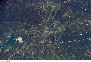
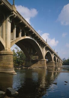
The city is located about 13 ميل (21 km) northwest of the geographic center of South Carolina, and is the primary city of the Midlands region of the state. It lies at the confluence of the Saluda River and the Broad River, which merge at Columbia to form the Congaree River. As the state capital, Columbia is the site of the South Carolina State House, the center of government for the state. In 1860, the South Carolina Secession Convention took place here; delegates voted for secession, making this the first state to leave the Union in the events leading up to the Civil War. The first six states to secede were those whose planters held the most enslaved African Americans; these were slave societies.
Columbia is home to the University of South Carolina, the state's flagship public university and the largest in the state. The area has benefited from Congressional support for Southern military installations. Columbia is the site of Fort Jackson, the largest United States Army installation for Basic Combat Training. Twenty miles to the east of the city is McEntire Joint National Guard Base, which is operated by the U.S. Air Force and is used as a training base for the 169th Fighter Wing of the South Carolina Air National Guard.
التاريخ
التاريخ المبكر
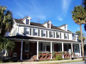

In May 1540, a Spanish expedition led by Hernando de Soto traversed what is now Columbia while moving northward on exploration of the interior of the Southeast. The expedition produced the earliest written historical records of this area, which was part of the regional Cofitachequi chiefdom of the Mississippian culture.[7]
During the colonial era, European settlers encountered the Congaree in this area, who inhabited several villages along the Congaree River. The settlers established a frontier fort and fur trading post named after the Congaree, on the west bank of the Congaree River. It was at the fall line and the head of navigation in the Santee River system.
In 1754 the colonial government in South Carolina established a ferry to connect the fort with the growing European settlements on the higher ground on the east bank.[8]
الجغرافيا
المناخ
قالب:Columbia, South Carolina weatherbox
الديمغرافيا
| التعداد | Pop. | ملاحظة | %± |
|---|---|---|---|
| 1830 | 3٬310 | — | |
| 1840 | 4٬340 | 31٫1% | |
| 1850 | 6٬060 | 39٫6% | |
| 1860 | 8٬052 | 32٫9% | |
| 1870 | 9٬298 | 15٫5% | |
| 1880 | 10٬036 | 7٫9% | |
| 1890 | 15٬353 | 53�0% | |
| 1900 | 21٬108 | 37٫5% | |
| 1910 | 26٬319 | 24٫7% | |
| 1920 | 37٬524 | 42٫6% | |
| 1930 | 51٬581 | 37٫5% | |
| 1940 | 62٬396 | 21�0% | |
| 1950 | 86٬914 | 39٫3% | |
| 1960 | 97٬433 | 12٫1% | |
| 1970 | 112٬542 | 15٫5% | |
| 1980 | 101٬208 | −10٫1% | |
| 1990 | 98٬052 | −3٫1% | |
| 2000 | 116٬278 | 18٫6% | |
| 2010 | 129٬272 | 11٫2% | |
| 2020 | 136٬632 | 5٫7% | |
| U.S. Decennial Census[9] | |||
As of the census of 2010, there were 129,272 people, 52,471 total households, and 22,638 families residing in the city. The population density was 928.6 people per square mile (358.5/km2). There were 46,142 housing units at an average density of 368.5 per square mile (142.3/km2). The racial makeup of the city was 51.27% White, 42.20% Black, 2.20% Asian, 0.25% Native American, 0.30% Pacific Islander, 1.50% from other races, and 2.00% from two or more races. Hispanic or Latino of any race were 4.30% of the population.
Economy

Columbia enjoys a diversified economy, with the major employers in the area being South Carolina state government, the Palmetto Health hospital system, Blue Cross Blue Shield of South Carolina, Palmetto GBA, and the University of South Carolina. Other major employers in the Columbia area include Computer Sciences Corporation, Fort Jackson, the U.S. Army's largest and most active initial entry training installation,[11] Richland School District One, Humana/TriCare, and the United Parcel Service, which operates its Southeastern Regional Hub at the Columbia Metropolitan Airport. Major manufacturers such as Square D, CMC Steel, Spirax Sarco, Michelin, International Paper, Pirelli Cables, Honeywell, Westinghouse Electric, Harsco Track Tech, Trane, Intertape Polymer Group, Union Switch & Signal, FN Herstal, Solectron, and Bose Technology have facilities in the Columbia area. There are over 70 foreign affiliated companies and fourteen Fortune 500 companies in the region.
Accolades
Columbia has been the recipient of several awards and achievements. In October 2009, Columbia was listed in U.S. News & World Report as one of the best places to retire, citing location and median housing price as key contributors.[12] As of July 2013 Columbia was named one of "10 Great Cities to Live In" by Kiplinger Magazine. Most recently, the city has been named a top mid-sized market in the nation for relocating families,[13] as well as one of 30 communities named "America's Most Livable Communities," an award given by the non-profit Partners for Livable Communities.
Sister cities
The city of Columbia has seven sister cities:[14]
 Kaiserslautern, Rhineland-Palatinate, Germany
 Cluj-Napoca, Romania
 Plovdiv, Bulgaria
 Chelyabinsk, Chelyabinsk Oblast, Russia
 Yibin, Sichuan, China
 Accra, Ghana
 Taichung City, Taiwan
See also
- Columbia High School (Columbia, South Carolina)
- Columbia, Newberry and Laurens Railroad, historic railroad
- Columbia Record, former afternoon daily newspaper
- Columbia Speedway
- Columbia South Carolina Temple, an operating temple of The Church of Jesus Christ of Latter-day Saints
- Columbia Theological Seminary, formerly in Columbia, South Carolina, now in Decatur, Georgia
- George Stinney, youngest person to be executed in the United States
Notes
References
- ^ أ ب "History - Soda City". sodacitysc.com. Retrieved 17 April 2021.
- ^ "2019 U.S. Gazetteer Files". United States Census Bureau. Retrieved July 29, 2020.
- ^ أ ب "US Board on Geographic Names". United States Geological Survey. October 25, 2007. Archived from the original on February 26, 2012. Retrieved January 31, 2008.
- ^ "QuickFacts: Columbia city, South Carolina". census.gov. Retrieved 2021-10-13.
- ^ "Columbia city, South Carolina". Census Bureau. Census Bureau. Retrieved October 1, 2016.
- ^ "2020 Population and Housing State Data". United States Census Bureau, Population Division. 2021-08-12. Retrieved 2021-10-13.
- ^ Charles Hudson (September 1998). Knights of Spain, Warriors of the Sun: Hernando de Soto and the South's Ancient Chiefdoms. University of Georgia Press. pp. 234–238. ISBN 978-0-8203-2062-5. Archived from the original on October 9, 2013. Retrieved February 16, 2012.
- ^ "A Brief History of Columbia." Archived فبراير 19, 2015 at the Wayback Machine City of Columbia Official Web Site. columbiasc.net. Retrieved February 20, 2015.
- ^ United States Census Bureau. "Census of Population and Housing". Archived from the original on April 26, 2015. Retrieved June 13, 2013.
- ^ "Population and Housing Unit Estimates". Retrieved May 21, 2020.
- ^ Fort Jackson South Carolina Archived يونيو 16, 2010 at the Wayback Machine. Jackson.army.mil. Retrieved on September 29, 2010.
- ^ Wolgemuth, Liz. "Best Places to Retire". U.S. News & World Report. 146 (9): 38.
- ^ Worldwide ERC and Primacy Relocation Archived يونيو 14, 2007 at the Wayback Machine, 2007
- ^ Columbia World Affair Council. "Columbia's Sister Cities". Archived from the original on May 14, 2019. Retrieved 21 June 2019.
External links
| Find more about Columbia, South Carolina at Wikipedia's sister projects | |
| Definitions from Wiktionary | |
| Media from Commons | |
| Quotations from Wikiquote | |
| Source texts from Wikisource | |
| Textbooks from Wikibooks | |
| Travel guide from Wikivoyage | |
| Learning resources from Wikiversity | |
قالب:Lexington County, South Carolina قالب:Richland County, South Carolina
- Pages using gadget WikiMiniAtlas
- Short description is different from Wikidata
- Pages using infobox settlement with possible motto list
- Coordinates on Wikidata
- صفحات تستخدم جدول مستوطنة بقائمة محتملة لمفاتيح الهاتف
- Articles with hatnote templates targeting a nonexistent page
- Pages with empty portal template
- Portal-inline template with redlinked portals
- Columbia, South Carolina
- 1787 establishments in South Carolina
- Cities in Lexington County, South Carolina
- Cities in Richland County, South Carolina
- Cities in South Carolina
- Columbia metropolitan area (South Carolina)
- County seats in South Carolina
- Planned cities in the United States
- Populated places established in 1787


