غودش
Nickname: جزيرة كاليپسو | |
|---|---|
| خطأ: الوظيفة "auto" غير موجودة. خطأ: الوظيفة "autocaption" غير موجودة. | |
| الجغرافيا | |
| الموقع | جنوب صقلية، البحر المتوسط |
| الإحداثيات | 36°03′N 14°15′E / 36.050°N 14.250°E |
| الأرخبيل | الجزر المالطية |
| المساحة | 67 km2 (26 sq mi) |
| الطول | 14 km (8٫7 mi) |
| العرض | 7٫25 km (4٫505 mi) |
| الإدارة | |
مالطا | |
| السكان | |
| اسم المواطن | Gozitans |
| التعداد | 37,342 |
| الكثافة السكانية | 557 /km2 (1٬443 /sq mi) |
| اللغات | المالطية (الوطنية/الرسمية) |
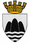
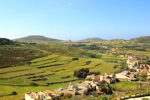
غودش (مالطية: Għawdex؛ تـُنطق [ˈaˤːw.dɛʃ],[1] سابقاً: Gaulos؛ إنگليزية: Gozo؛ /ˈɡoʊ.zoʊ/)[2][3] هي جزيرة في أرخبيل مالطا في البحر المتوسط. الجزيرة هي جزء من مالطا. وبعد جزيرة مالطا نفسها، فإنها ثاني أكبر جزيرة في الأرخبيل. وبالمقارنة لجارتها الجنوبية الشرقية، فإن غودش أكثر ريفية وتشتهر بمناظر تلالها، التي تظهر على درع الجزيرة.[4]
The island of Gozo has long been associated with Ogygia, the island home of the nymph Calypso in Homer's Odyssey. In that story, Calypso, possessed of great supernatural powers, and in love with Odysseus, holds him captive for a number of years, until finally releasing him to continue his journey home.[5]
As of March 2015, the island has a population of around 37,342, all of Malta combined has 445,000, and its inhabitants are known as Gozitans (مالطية: Għawdxin). It is rich in historic locations such as the Ġgantija temples, which, along with the other Megalithic Temples of Malta, are among the world's oldest free-standing structures.[6]
The island is rural in character and, compared to the main island Malta, less developed. It was known for the Azure Window, a natural limestone arch that was a remarkable geological feature, until its collapse in 2017. The island has other notable natural features, including the Inland Sea and Wied il-Mielaħ Window. There are many beaches on the island, as well as seaside resorts that are popular with both locals and tourists, the most popular being Marsalforn and Xlendi. Gozo is considered one of the top diving destinations in the Mediterranean and a centre for water sports.[7]
التاريخ
Gozo has been inhabited since 5000 BC, when farmers from nearby Sicily crossed the sea to the island.[8] Due to the discovery of similar pottery found in both places from the Għar Dalam phase, it has been suggested that the first colonists were specifically from the area of Agrigento; however, it is currently indeterminate exactly which part of Sicily the farmers came from. They are thought to have first lived in caves on the outskirts of what is now known as San Lawrenz.[8]
Gozo was an important place for cultural evolution, and during the neolithic period the Ġgantija temples were built; they are among the world's oldest free-standing structures, as well as the world's oldest religious structures. The temple's name is Maltese for "belonging to the giants", because legend in Maltese and Gozitan folklore says the temples were built by giants.[6] Another important Maltese archaeological site in Gozo, which dates back to the neolithic period, is the Xagħra Stone Circle. Also, native tradition and certain ancient Greek historians (notably Euhemerus and Callimachus) maintain that Gozo is the island Homer described as Ogygia, home of the nymph Calypso.[9]
In July 1551 Ottomans under Sinan Pasha and Dragut invaded and ravaged Gozo and enslaved most of its inhabitants, about 5,000, bringing them to Tarhuna Wa Msalata in Libya, their departure port in Gozo was Mġarr ix-Xini. The island of Gozo was repopulated between 1565 and 1580 by people from mainland Malta, undertaken by the Knights of Malta.[10]
The history of Gozo is strongly coupled with the history of Malta, since Gozo has been governed by Malta throughout history, with the brief exception of a short period of autonomy following the uprising against the French forces after Napoleon's conquest of Malta, between 28 October 1798 and 20 August 1801.[10]
الجغرافيا
Gozo is famed for its character and places of interest. Some of these include the Calypso Cave and the Ġgantija Neolithic temples which are among the oldest surviving man-made structures.[11]
Gozo covers 67 متر كيلومربع (26 sq mi), approximately the same area as New York City's Manhattan island. It lies approximately 6 كيلومتر (4 mi) northwest of the nearest point of Malta, is of oval form, and is 14 كيلومتر (8.7 mi) long and 7.25 كيلومتر (4.50 mi) wide.[12]
Notable beaches in Gozo include San Blas and the beach at Ramla Bay.[13]
سمات بارزة
The following is a list of notable features in Gozo:[14]
- Santwarju tal-Madonna ta' Pinu
- St George's Basilica
- Rotunda of Xewkija
- Inland Sea
- Fungus Rock
- Ramla Bay
- Fontana Springs
- Gozo FA
انظر أيضاً
الهامش
- ^ Grenville Temple (1836). "Excursions in the Mediterranean". p. 200.
- ^ Gaulos (island) – pleiades.stoa.org
- ^ Gaulos (Gozo) – trismegistos.org
- ^ "Coat of Arms of the Island Region of Gozo". VisitGozo.com. October 2013. Retrieved 22 June 2015.
- ^ "Calypso's Cave". VisitGozo.com. Retrieved 22 June 2015.
- ^ أ ب "Ġgantija Temples". Heritage Malta. Retrieved 16 August 2015.
- ^ "Where is Gozo?". Gozo & Malta. Retrieved 26 March 2013.
- ^ أ ب "History of Gozo". islandofgozo.org. Gozo Tourism Association. Retrieved 25 November 2014.
- ^ http://www.timesofmalta.com/articles/view/20070621/opinion/gozos-encounter-with-the-greatest-homeric-hero-the-final-chapter.13802
- ^ أ ب http://www.maltabulb.com/gozo-citadel.html
- ^ http://www.boston.com/travel/getaways/europe/articles/2009/07/26/on_malta_discover_ancient_salt_pans_and_the_stuff_of_legends/
- ^ http://www.georgiarosebooks.com/gozo-1st-day-winding-down-in-westworld/
- ^ http://www.perfectbay.com/malta-beaches-ramla-bay-in-gozo/
- ^ http://www.seemalta.net/MalteseIslands/AboutGozo/GozoHighlights.aspx
وصلات خارجية
- Pages using gadget WikiMiniAtlas
- Pages using infobox islands with unknown parameters
- Articles containing مالطية-language text
- Pages using Lang-xx templates
- Articles containing إنگليزية-language text
- Pages with empty portal template
- Coordinates on Wikidata
- Gozo
- جزر مالطا
- مستعمرات فينيقية
- أقاليم التصنيف الثالث في الاتحاد الأوروپي


