الرقة
الرقة | |
|---|---|
City | |
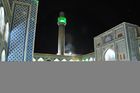
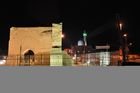
 Raqqa skyline • The Euphrates Raqqa city walls • Baghdad gate Qasr al-Banat Castle • Uwais al-Qarni Mosque | |
 الرقة موقع الرقة في سوريا  الرقة الرقة (Eastern Mediterranean)  الرقة الرقة (آسيا) | |
| Coordinates: 35°57′N 39°1′E / 35.950°N 39.017°E | |
| البلد | |
| المحافظة | الرقة |
| المنطقة | منطقة الرقة |
| الناحية | الرقة |
| تأسست | 244-242 ق.م |
| Area | |
• City | 1٬962 كم² (758 ميل²) |
| Elevation | 245 m (804 ft) |
| Population (2012) | |
• City | 220٬268 |
| • Metro | 338٬773 |
| Time zone | UTC+2 (توقيت شرق أوروبا) |
| • Summer (DST) | +3 |
| Area code | 22 |
| Website | http://www.esyria.sy/eraqqa/ العربية: قالب:Description/i18n |
الرقة، مدينة في شمال وسط سوريا، عاصمة محافظة الرقة، تقع على الضفة الشمالية لنهر الفرات، على بعد حوالي 160 كم شرق مدينة حلب. منذ أواسط السبعينيات يعتمد اقتصاد الرقة على سد الفرات وعلى الزراعة وعلى الحقول النفطية المجاورة. في الرقة متحف تاريخي صغير يسمى متحف الرقة، وقد كشفت الحفريات فيها عن آثار تعود إلى العصر العباسي (750 هـ - 1258). من أهم الآثار الباقية في المدينة قصر العذارى أو قصر البنات، والجامع الكبير الذي بني في القرن الثامن الميلادي. تحتوي المدينة القديمة أيضاً على أضرحة عدد من رجال الدين المسلمين، منهم الصحابي عمار بن ياسر وأويس القرني، عدد سكان المدينة يزيد على 220,000 نسمة.
التسمية

أنشئت الرقة عام 244 أو 242 قبل الميلاد وسميت في البداية كالينيكوس، نسبة إلى سلوقس الأول، مؤسس المدينة، الذي كان يعرف أيضاً بهذا الاسم (ويقول البعض أن الاسم يعود إلى الفيلسوف اليوناني كالينيكوس الذي يعتقد أنّه توفي في الرقة). في العصر البيزنطي، كانت المدينة مركزاً اقتصادياً وعسكرياً. في 639 فتحتها الجيوش العربية الإسلامية وتحولت تسميتها إلى الرقة وتعني في اللغة الصخرة المسطّحة.
التاريخ
الكالينيكوس الهلينية والبيزنطية
كانت مناطق محافظة الرقة مأهولة بالسكان منذ العصور القديمة، كما تشهد على ذلك التلال المنشرة فيها ولا سيما في تل زيدان وتل البيعة. بينت الرقة الحديثة في زمن الإغريق فقد بناها الإسكندر الكبير بعد أن قطع نهر الفرات وقد سماها "نيكفوريوم" الاسم الذي حملته لفترة طويلة قبل العهد الهلنستي الذي جاء لها باسم جديد لتعيش فيه زمنا آخر، إذ إنها كانت قد سميت "قالينيقوس" تبعاً لاسم الإمبراطور سلوقس الثاني أو قالينيقوس والذي كان أيضا يعني الأرض المنبسطة وكثيرة المياه وسلوقس هو مؤسس الإمبراطورية السلوقية الذي جدد المدينة القديمة فيها في الفترة بين 244-242 ق.م، وذبك في منطقة تل البيعة الحالية التي بقيت قائمة حتى جاء العصر الروماني لتحمل هذه المدينة التي كانت تعيش في أسمائها اسماً جديدا يدل على ما كان لهذه المدينة من قيمة عالية على مر حضارات الأرض بسبب موقعها الجغرافي كواسطة بين الشمال والجنوب وبين الغرب والشرق وكمدينة تزدهي بمياه الفرات مثلما ازدهى الفرات بها إذ حملت المدينة في العصر الروماني اسم "كالينيكيوم" وذلك أيضاً اسم يعود إلى الإمبراطور الروماني گالينوس من عام 266 بعد الميلاد. الذي جدد المدينة وأقام فيها.
لكن الرقة كانت قد تحولت إلى مركز عسكري محصن جدا بأسوار في عهد الإمبراطور الروماني جوليان، وكانت تعد مدينة حدودية مع الفرس. وعصفت بالمدينة هزة أرضية، فجددها الإمبراطور ليون الثاني وفي عام 474 تعرضت المدينة لهزة أرضية عنيفة دمرتها، وسماها أيضا من جديد باسمه "ليونتوبوليس" ليضيف لأسمائها اسماً جديداً، وفي سنة 529 منحها الإمبراطور جوستنيان منحة تجارية تربح منها، عندما قرر حصر التجارة في مدن الحدود مع الفرس بمدينة نصيبين وقالينيقوس (الرقة) وارثكساتا. لعبت المدينة دورًا مهمًا في علاقات الإمبراطورية البيزنطية مع الامبراطورية الساسانية والحروب التي دارت رحاها بين الإمبراطوريتين. كانت المدينة بالقرب من موقع معركة عام 531 بين الرومان والساسانيين، عندما حاول الساسانيون غزو الأراضي الرومانية، فجأةً عبر المناطق القاحلة في سوريا، لقلب مجرى الحرب الايبيرية. انتصر الفرس في المعركة، لكن الخسائر كانت مرتفعة في كلا الجانبين. في عام 542، تم تدمير المدينة على يد الإمبراطور الفارسي خسرو الأول (حكم من 531 إلى 579)، الذي دمر تحصيناتها ورحل سكانها إلى بلاد فارس، وعمد إلى توطين قبيلة مضر العربية فيها، ما جعل كل منطقة الجزيرة تعرف بديار مضر، وكانت الرقة (كالينيكوس) عاصمة لها.[1]
أعيد بناؤها لاحقاً على يد الإمبراطور البيزنطي جستنيان الأول (حكم من 527 إلى 565). في عام 580، أثناء حرب أخرى مع بلاد فارس، سجل الإمبراطور المستقبلي موريس انتصاراً على الفرس بالقرب من المدينة أثناء انسحابه من حرب فاشلة.[2] في السنوات الأخيرة قبل وقوعها تحت الحكم الإسلامي، كانت الرقة (كالينيكوس) مهمة مثل أي مركز حضري آخر في المنطقة، واستناداً إلى المساحة المادية التي تغطيها كانت أصغر قليلاً من دمشق[3]
العصر الإسلامي المبكر


فتح العرب المسلمون الرقة بقيادة عياض بن غنم سنة 17هـ -639، وضمت مجموعات كبيرة من العرب المسلمين الجدد، الذين أقاموا فيها جنباً إلى جنب، مع العرب المسيحيين وغيرهم من المكونات القومية الأخرى، والجميع شرعوا في بناء مدينتهم، التي اتسعت رقعتها، وأصبحت فيما بعد سبع مدن متجاورة، وبذلك كانت "الرقة" قاعدة ديار "مضر" في الجزيرة الفراتية، وتعتبر مقبرة أويس القرني من أولى المقابر في الإسلام، وفي الرقة أيضاً مقامات كل من "أويس القرني" ، و"عمار بن ياسر" ، و"أبي بن كعب النخعي"، ويقال أن علي بي أبي طالب زارها. ومن المساجد الأولى التي شيدت في "الرقة"، مسجد الرقة الكبير، الذي يعتبر من المساجد الأولى في الإسلام وكان يسميه أهل الرقة جامع المنيطير ومساحته /100×100/م وهي نفس مساحة مسجد المنصور المتواجد بالمدينة حالياً، وقد شيد مسجد "الرقة البيضاء الكبير" سنة 20هـ-641، وذلك في عهد واليها الثاني سعيد بن عامر بن حذي، أيام الخليفة عمر بن الخطاب. ومن المساجد الأخرى التي شيدت فيها، المسجد المعلق، ومسجد الجنائز، ومسجد "ابن الصباح"، ومسجد "قريش"، ومسجد بني "وابصة".. وبالقرب من مسجد "قريش" شيد بنو أمية "دار الرماح"، وكانت أحد الدور العظيمة، وأحد المعالم البارزة في المدينة. واستمرت الرقة تتمتع بحرية المعتقد الديني في ظل حكم بني أمية، واستفادت من موقعها الجغرافي الذي أهلها أن تكون، محطة تموين مهمة للجيوش القادمة من الشام إلى العراق، وأهلها هذا الموقع أن تكون سوق تجارية كبيرة بين الجزيرة، والعراق، والشام، وقد اشتهرت بمنتجاتها من الحبوب والبقوليات وزيت الزيتون والخل والعسل، وكانت أسواقها كبيرة ومشهورة، ومنها سوق العطارين الذي ذكره "الأخطل" بقوله : "إذا الرقة البيضاء لاحت *** بروجها فدى كل عطار بها أم مريم." ويشار أن أم مريم هذه كانت صاحبة حانات ثلاثة واحدة في "الرقة البيضاء"، والثانية في " رقة واسط" ، والحانة الثالثة في محلة "دامان"، إحدى قرى "الرقة" المشهورة ببساتينها وتفاحها. وكان أكبر وأعظم أسواق" الرقة البيضاء"، سوق "هشام" العتيق، وقد ذكره ياقوت الحموي بقوله: "وكان سوق "الرقة" الأعظم، فيما مضى، يعرف بسوق "هشام" العتيق»[4]، وكان فيها أسواق أخرى مثل سوق الأحد، وسوق البزازين. ويصف المقدسي الرقة البيضاء في كتابه أحسن التقاسيم في معرفة الأقاليم بقوله "غير أنها طيبة نزهة، قديمة الخطة، حسنة الأسواق، كثيرة القرى والبساتين والخيرات، ومعدن الصابون الجيد والزيتون، ولها جامع عجيب، وحمامات طيبة، قد ظللتها أسواقها، وبريقت قصورها، وانتشر في الإقليمين ذكرها، فالشام على تخمها، والفرات إلى جنبها، والعلم كثير بها.[5] هذا وقد اشتهرت "الرقة" بتصدير الصابون والزيت وأقلام الرصاص وصناعة ريش الكتابة المعدنية. كما اشتهرت بصناعة الأدوية، ويذكر ابن الفقيه في كتابه مختصر البلدان، شهرة بعض المحلات في أسواق "الرقة" ببيع دهن يسمى (الخطارة) وهو دواء يستعمله الناس لدواء أمراض (الروماتزم والنقرس).[6]
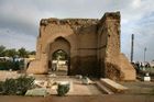
حين استلم العباسيون دفة الخلافة، أمر الخليفة المنصور ابنه المهدي ببناء مدينة بالقرب من "الرقة البيضاء" على أن تكون رفيقة لها، وسماها "الرافقة"، والتي انتقل إليها اسم "الرقة" ومكانتها فيما بعد. وشيد المهندس أدهم بن محرز مدينة "الرافقة" على بعد /300/ ذراع غرب "الرقة البيضاء"، وجعل لها مخططاً على شكل نعل الفرس، يلفها سوران شيدا من مادة اللبن، ولفحا بمادة الآجر المحروق، طول السور الرئيسي 5 كم، وعرضه 6 أمتار، وارتفاع 9 أمتار تقريباً، وجعل له ثلاث بوابات، لم يبقَ منها سوى واجهة باب "بغداد" في الزاوية الشرقية الجنوبية من سور المدينة، كما أمر "الخليفة المنصور"، ببناء مسجد كبير أبعاده /100×100/م ، وهو يشبه مسجد "الرقة البيضاء" في أبعاده، كما شيدت ضمن السور مجموعة من القصور، لم يبقَ منها إلاَّ قصر البنات، الذي حول في القرن الثالث عشر ميلادي إلى مدرسة طبية. وحين استلم "الرشيد" سدة الخلافة في العقد الأخير من القرن الثامن الميلادي، نقل مركز الخلافة من "بغداد" إلى "الرقة"، إذ أنه قام بتشييد مدينة خارج الأسوار في الجهة الشرقية الشمالية من ضلع سور الرافقة الشرقي (مكان حي رميلة حالياً)، وما أن دخل القرن التاسع الميلادي، حتى توسعت هذه المدينة، مدينة الرشيد الجديدة، وأصبحت مساحتها /4×5كم/، ومازالت أطلال قصور الرشيد ظاهرة للعيان، ومنها قصر السلام المطل على الفرات من جهة الجنوب. ومع مجيء "الرشيد" إلى "الرقة" و"الرافقة"، انتقل معه مجموعة كبيرة من العلماء والفقهاء والشعراء، وجمعيهم شكلوا شموعاً أضاءت سماء وفضاءات آنذاك. وفي عهده أصبحت المدينة مركز إشعاع فكري وعلمي، إذ تخرّج في مدارسها أدباء ولغويون وشعراء وفقهاء وقضاة وفلاسفة وأطباء ومحدثون. وظلت "الرقة" حتى خرابها على يد المغول عام 1258، نشطة في حركتها العلمية والأدبية، ومركزاً هاماً من مراكز العلم والأدب، ونبغ اسمها في كافة المجالات، وكان أبناؤها يحملون نسبتهم إليها الرقي أو الرقيون في مختلف عصورها من الفقهاء والعلماء والأدباء والشعراء، وصناع الفخار والزجاج وغيرهم من أصحاب المهن، وكان الكتاب والعلماء والفقهاء والشعراء، الذين قدموا إلى "الرقة" في زمن "الرشيد" من جميع أنحاء الخلافة، وأقاموا فيها مدداً مختلفة، وبعضهم سكنها حتى ساعة وفاته، وظلوا يحملون اسم الرقي أو الرقيون. In the year 639 or 640, the city fell to the Muslim conqueror Iyad ibn Ghanm.[7] Since then, it has been known by the Arabic name al-Raqqah, or "the morass", after its marshy surroundings at the time.[3] At the surrender of the city, the Christian inhabitants concluded a treaty with Ibn Ghanm that is quoted by al-Baladhuri. The treaty allowed them freedom of worship in their existing churches but forbade the construction of new ones. The city retained an active Christian community well into the Middle Ages (Michael the Syrian records 20 Syriac Orthodox (Jacobite) bishops from the 8th to the 12th centuries[8]), and it had at least four monasteries, of which the Saint Zaccheus Monastery remained the most prominent one.[7] The city's Jewish community also survived until at least the 12th century, when the traveller Benjamin of Tudela visited it and attended its synagogue.[7] At least during the Umayyad period, the city was also home to a small Sabian pagan community.[9]
Ibn Ghanm's successor as governor of Raqqa and the Jazira, Sa'id ibn Amir ibn Hidhyam, built the city's first mosque. The building was later enlarged to monumental proportions, measuring some 73 في 108 متر (240 في 354 أقدام), with a square brick minaret added later, possibly in the mid-10th century. The mosque survived until the early 20th century, being described by the German archaeologist Ernst Herzfeld in 1907, but has since vanished.[7] Many companions of Muhammad lived in Raqqa.
In 656, during the First Fitna, the Battle of Siffin, the decisive clash between Ali and the Umayyad Mu'awiya took place about 45 كيلومتر (28 mi) west of Raqqa. The tombs of several of Ali's followers (such as Ammar ibn Yasir and Uwais al-Qarani) are in Raqqa and have become sites of pilgrimage.[7] The city also contained a column with Ali's autograph, but it was removed in the 12th century and taken to Aleppo's Ghawth Mosque.[7]
The Islamic conquest of the region did not disrupt the existing trade routes too much, and new Byzantine coins continued to make their way into Raqqa until about 655-8.[10] The Byzantine government may have seen the area as just temporarily in rebellion.[10] Byzantine coinage probably continued to circulate until at least the 690s, if not even longer.[10]
Raqqa appears to have remained an important regional center under Umayyad rule.[10] The Umayyads invested in agriculture in the region, expanding the amount of irrigated farmland and setting the stage for an "economic blossoming" during and after their rule.[10]
The strategic importance of Raqqa grew during the wars at the end of the Umayyad Caliphate and the beginning of the Abbasid Caliphate. Raqqa lay on the crossroads between Syria and Iraq and the road between Damascus, Palmyra and the temporary seat of the caliphate Resafa, al-Ruha'.
العصر العباسي

في عام 772 هـ بدأ الخليفة العباسي المنصور ببناء عاصمة صيفية للدولة العباسية بالقرب من الرقة، سميت الرافقة. بنيت المدينة الجديدة بشكل حدوة فرس على الطراز المعماري لبغداد، وسرعان ما اندمجت مع الرقة. وبين عامي 796 و808 استعمل الخليفة العباسي هارون الرشيد الرقة عاصمة له أيضاً، وأصبحت المدينة مركزاً علمياً وثقافياً هاماً. في الرقة عاش وتعلم الفلكي العربي الشهير البتاني (858-929). في عام 1258 دمر المغول الرقة كما فعلوا ببغداد. The most critical part of this project was to secure the northwestern frontier with the Byzantine Empire, and al-Rafiqah was its largest and most important construction.[3] It also happens to be the only one that survives to the present day.[3] Although most of the interior layout of al-Rafiqah has since been built over, and much of its fortifications have also been demolished, about 2،660 متر (8،730 أقدام) of its massive city walls are still standing, as well as its congregational mosque – the first in the world to be built from scratch on "a coherent, integrated plan" and a major influence on later mosque architecture.[3]
Although al-Mansur had conceived the vision for al-Rafiqah in 770-1, it wasn't until the next year that construction actually started.[3] The caliph sent his son and eventual successor al-Mahdi to personally supervise the construction of the new city that year.[3] The chronicle of Pseudo-Dionysius indicates that workmen were brought from all over Mesopotamia to work on the construction, hinting at the monumental scale of this project.[3] According to al-Tabari, the plan of al-Rafiqah was basically the same as that of Baghdad: it was built with "the same gates, intervallum (fuṣūl), squares, and streets" as the recently-built Abbasid capital.[3] In practice, there were some significant differences between the two: al-Rafiqah was somewhat smaller but more heavily fortified than Baghdad, and its shape was more elongated along a north-south axis instead of the famously round city of Baghdad.[3] Construction continued at al-Rafiqah at least until 774-5, when al-Mahdi was again sent to check on its progress.[3]
At least at the beginning of the construction work on al-Rafiqah, the indigenous residents of Raqqa were hostile to the military settlement – they expected a rise in their own cost of living.[9] The newcomers were soldiers from Khorasan, in contrast to the Christians and Arabs who lived in the old city.[9]
By 785, the old market of Raqqa had probably become physically too small to serve the needs of both it and al-Rafiqah.[9] That year, Ali ibn Sulayman, the city's governor, moved the market from the old city of Raqqa to the agricultural land between the two cities.[9] This probably marks the start of al-Muhtariqa, the industrial and commercial suburb located between the two (see below).[9] (The old market, associated with the Umayyad caliph Hisham, had been just north of the old city, outside the Bāb al-Ruhā' – near the later industrial site of Tall Aswad.)[9]
Raqqa and al-Rāfiqah merged into one urban complex, together larger than the former Umayyad capital, Damascus. In 796, the caliph Harun al-Rashid chose Raqqa/al-Rafiqah as his imperial residence. For about 13 years, Raqqa was the capital of the Abbasid Caliphate, which stretched from Northern Africa to Central Asia, but the main administrative body remained in Baghdad. The palace area of Raqqa covered an area of about 10 متر كيلومربع (3.9 sq mi) north of the twin cities. One of the founding fathers of the Hanafi school of law, Muḥammad ash-Shaibānī, was chief qadi (judge) in Raqqa. The splendour of the court in Raqqa is documented in several poems, collected by Abu al-Faraj al-Isfahāni in his "Book of Songs" (Kitāb al-Aghāni). Only the small, restored so-called Eastern Palace at the fringes of the palace district gives an impression of Abbasid architecture. Some of the palace complexes dating to the period have been excavated by a German team on behalf of the Director General of Antiquities. There was also a thriving industrial complex located between the twin cities. Both German and English teams have excavated parts of the industrial complex, revealing comprehensive evidence for pottery and glass production. Apart from large dumps of debris, the evidence consisted of pottery and glass workshops, containing the remains of pottery kilns and glass furnaces.[11]

Approximately 8 كيلومتر (5.0 mi) west of Raqqa lay the unfinished victory monument Heraqla from the time of Harun al-Rashid. It is said to commemorate the conquest of the Byzantine city of Herakleia in Asia Minor in 806. Other theories connect it with cosmological events. The monument is preserved in a substructure of a square building in the centre of a circular walled enclosure, 500 متر (1،600 ft) in diameter. However, the upper part was never finished because of the sudden death of Harun al-Rashid in Greater Khorasan.
Harun al-Rashid also invested in the water supply in Raqqa.[13] Under his rule, canals were dug along the Euphrates and Balikh rivers; they brought water from the area around Saruj to be used for domestic and agricultural purposes, as well as to supply the palace gardens with water.[13] Meanwhile, the influx of residents generated plenty of demand for food, goods, and services, stimulating the economy and resulting in intensified activity in Raqqa's rural hinterland.[13] Rural towns such as Hisn Maslama, Tall Mahra, and al-Jarud flourished and reached their peak size.[13] The surrounding countryside at this time was "one of the richest agricultural areas of the empire, with an extensive system of irrigation canals".[13]
After the return of the court to Baghdad in 809, Raqqa remained the capital of the western part of the Abbasid Caliphate.
جغرافيا الرقة العباسية
The name "Raqqa" was used both for the entire urban sprawl, or more specifically for the old city of Raqqa aka Kallinikos.[9] The old city was also known by the name al-Raqqah al-Bayḍā'.[10] It had "almost rectangular" walls, although their entire extent is not known.[9] Where the gates were located is also unknown.[9] This area had a predominantly indigenous population.[9]
الرافقة
Somewhat to the west of Raqqa proper was al-Rāfiqah, which had horseshoe-shaped walls.[9] Al-Rafiqah represents the location of present-day Raqqa; at some point the main center shifted here.[9] The earliest evidence for this shift is a Fatimid dinar minted at Raqqa in 1010-11, which uses the name Raqqa rather than the official Abbasid name of al-Rafiqah.[14] The writer Ibn al-Sam'ani also recorded this shift over a century later.[14] During Raqqa's rapid growth in the late 20th century, al-Rafiqah was almost completely built over with new construction, and today almost nothing remains of the Abbasid city.[3]
Still, about 2،660 متر (8،730 أقدام) of the original 4،580 متر (15،030 أقدام)-long city walls remain today, indicating the massive scale of al-Rafiqah's fortifications.[3] The 6.20m-thick walls themselves consisted of mud brick on a stone foundation, and their exterior was further reinforced by a stabilized burnt-brick cladding.[3] The walls had 132 towers.[3] Like the Abbasid capital of Baghdad, al-Rafiqah was protected by a series of outer defenses, which together made up a triple line of defense that any attackers would have to get through.[3] A second, outer wall, itself 4.5m thick, was built beyond the first wall (at a distance of 20.8m).[3] Beyond that, there was a 15.9m-wide moat.[3] Both the outer wall and the moat were bulldozed in the 1970s or 80s to make room for new construction.[3]
Although al-Rafiqah covered a much smaller area than the round city of Baghdad (less than half), it was much more heavily fortified because of its location close to the Byzantine frontier.[3] The walls of al-Rafiqah were built a meter thicker than Baghdad's, and it had more (and larger) defensive towers.[3]
The north gate of al-Rafiqah, excavated and partly rebuilt in the 1990s, is the earliest surviving city gate from the Abbasid period.[3] Its name was probably the Bāb Ḥarrān, or the Harran Gate.[3] Its basic layout is "a tower gate with a rectangular room and a deep entrance niche".[3] The structure is 18 متر (59 أقدام) tall, with a ramp on the west side leading up to the top.[3] The gateway was built from stone up to a height of about 2m (above that it was built from brick), while the door opening itself measures 4m.[3] Archaeologists found two door posts made out of solid iron still standing in place here.[3] These probably represent the last traces of a pair of massive iron doors, like the ones that historical texts often mention as part of the entryways to early Islamic cities and palaces.[3] For Raqqa in particular, although not necessarily the Bab Harran itself, different traditions mention an iron gate that originally was part of the Byzantine city of Amorion before being carried off to Samarra in 838 after the Abbasids captured and destroyed the city.[3] This door was then installed at the Bāb al-'Āmma, the main entrance to the caliph al-Mu'tasim's newly-built palace.[3] This door then supposedly found its way to Raqqa sometime later during the 9th century,[3] before then being removed in 964[10] by Sayf al-Dawla, the Hamdanid ruler of Aleppo, to renovate the Bāb Qinnasrīn in his capital.[3] It was then destroyed when the Mongols captured Aleppo in 1260, and its fragments were then taken by the Mamluk sultan Baibars to the citadels of Damascus and Cairo.[3]
Al-Rafiqah itself was laid out on a north-south axis, roughly aligned with the qibla.[3] A major north-south street connected the Bab Harran in the north with al-Rafiqah's Great Mosque, right at the center of the walled city.[3] The mosque is 108x93m, about the same size as the Abbasid mosque built at Baghdad a decade earlier.[3] However, its materials are more sophisticated: whereas the Baghdad mosque was originally made from mud bricks with wooden columns and ceiling, the al-Rafiqah mosque is entirely made out of kiln-fired bricks.[3] The roof of al-Rafiqah's mosque was also gabled, in contrast with the flat-roofed Baghdad mosque, showing an influence from earlier Umayyad mosque architecture in Syria, such as the Great Mosque of Damascus.[3] The al-Rafiqah mosque was renovated in 1165-6 by Nur ad-Din Mahmud Zengi, but an archaeological sounding revealed that this renovation did not change the basic structure, so its origins can be firmly dated to the Abbasid period.[3]
The al-Rafiqah mosque represents an important step in the history of mosque architecture.[3] Earlier mosques had mostly been repurposed from earlier pre-Muslim structures, like the Great Mosque of Damascus, or featured a very rudimentary design, such as the original mosque at Baghdad.[3] The al-Rafiqah mosque was the first to be built entirely from scratch on a coherent plan.[3] It had an important influence on later mosque architecture, beginning in 808 when Harun al-Rashid – who was living in Raqqa at the time and would have been familiar with the al-Rafiqah mosque – had the original mosque at Baghdad rebuilt, adopting features of the design at al-Rafiqah.[3] Later mosques such as the Great Mosque of Samarra and the Mosque of Ibn Tulun in Cairo also contain traces of its influence.[3]
المحترقة
Between Raqqa and al-Rafiqah was a large commercial and industrial area, which was called "al-Raqqa al-Muḥtariqa", or "the burning Raqqa", probably because of all the thick smoke coming from pottery kilns and glass furnaces.[9] This smoke may have affected Raqqa/Kallinikos and influenced its decline.[9] It appears that al-Muqaddasi viewed this district as its own distinct city (i.e. madina or misr), which according to legal norms at the time meant that it had to have a separate congregational mosque, and it had to be separated from other urban precincts by some sort of clearly-defined boundary.[9] The congregational mosque may have been the "mosque suspended on columns", or perhaps the Samarran complex near the Bab al-Sibal.[9]
Eventually a wall was built on the north side of al-Muhtariqa, probably to protect the central commercial district from Bedouin raids.[9] This is probably the wall that Tahir ibn al-Husayn built while he was governor, in the year following 1 October 815 according to the accounts of Michael the Syrian and Bar Hebraeus.[9] The wall, as visible in old aerial photographs, did not cover the industrial sites north of Raqqa/Kallinikos, leaving them unprotected.[9] Stefan Heidemann suggested that this may have been because those areas were exclusively used for industry, with no houses and no valuables to loot.[9]
Five main streets have been identified in al-Muhtariqa.[9] The northernmost runs eastward from the east gate of al-Rafiqah, called the Bāb al-Sibāl, past the still-unlocated northwestern corner of Raqqa/Kallinikos, and then along the north side of Raqqa/Kallinikos before finally ending around Tall Aswad in the northeast.[9] It passes by several mounds of medieval industrial debris in this area exist.[9] These include Tall Fukhkhār, a ceramic producing site; as well as Tall Ballūr, Tall Abī 'Alī, and Tall Zujāj, which were all glass workshops.[9] Henderson and McLoughlin suggested Tall Ballur may have later been a production site again during the late 11th century after 150 years of abandonment, and Tonghini and Henderson suggested the same for Tall Fukhkhar, although Heidemann considered the latter improbable.[9]
At the eastern end of this northern street, and to the northeast of Raqqa/Kallinikos, was Tall Aswad.[9] This was the largest and easternmost center of pottery production, and probably the oldest among the industrial mounds excavated.[9] It is a large mound consisting of ruins of kilns, potsherds, wasters, and industrial debris.[9] The site had many kilns producing pottery of various types including unglazed, moulded, and high-quality glazed.[9] It lay at the eastern end of the northernmost main road.[9] Its location was probably chosen because it was downwind from the rest of the city, so that the wind wouldn't blow smoke from its kilns over residents' houses.[9] However, this site was also vulnerable and exposed to nomadic attacks, which may have ultimately been the reason for its abandonment.[9] The latest coin find from here is from 825/6, and Tall Aswad probably declined in the first half of the 9th century.[9]
At the western end of the street, right outside the Bab al-Sibal, there was a 200x200m square compound which was probably built during the Samarran period.[9] It featured two rows of small rooms on different levels that were probably rows of shops.[9] There was also some construction to the north of this complex.[9]
The 2nd street runs southeast from the Bab al-Sibal towards the also-still-unlocated western gate of Raqqa/Kallinikos.[9] Like the 1st street, it appears to cut deep into the flat-topped tell formed by centuries of debris.[9] Further south was the southwestern gate of Raqqa/Kallinikos, which was called the Bāb al-Hajarayn.[9] This gate led to a cemetery where people who died in the Battle of Siffin were interred.[9] The most important of the tombs here was that of Uways al-Qarani, considered the "patron saint" of Raqqa; his tomb survived until the late 20th century when it was torn down and replaced with the new Uways al-Qarani mosque.[15][3] His name also became applied to the entire cemetery.[15]
West of the Bab al-Hajarayn was the mosque called the Masjid al-Janā'iz, also called the Mashhad al-Janā'iz.[9] This building is still unlocated.[9] Its existence is known from the 10th until the 13th centuries.[9] According to al-Qushayri, the Masjid al-Jana'iz was founded by a descendant of Muhammad named Abu Abdallah, a Khorasani who lived by the Bab al-Hajarayn near the city's moat.[9]
The 3rd street starts further south, from the unnamed Gate #2 on the east side of al-Rafiqah.[9] It crosses the 2nd street and probably converged with the 1st street at the northwestern corner of Raqqa/Kallinikos, where there was likely a gate.[9]
The 4th and 5th streets both have their west end at the Bab Baghdad.[9] Together, they mark the southern end of the al-Muhtariqa area.[9] Since the Bab Baghdad is a comparatively newer structure, probably from the late 11th or 12th century, these two streets might have also been built later.[9] The 4th street runs northeast toward the northwest corner of Raqqa/Kallinikos, where it probably converged with the 1st and 3rd streets.[9] As for the 5th street, it goes southeast, cutting through the Siffin cemetery and passing by the southwest corner of Raqqa/Kallinikos.[9]
The settlement of al-Muhtariqa probably began in 785, when the city's governor Ali ibn Sulayman transferred Raqqa's market from Raqqa/Kallinikos to somewhere between it and al-Rafiqah.[9] Before then, this area had been used for agriculture.[9] Later, al-Muhtariqa was expanded when Harun al-Rashid made Raqqa his capital, in order to serve the newly increased demand for luxury and everyday goods.[9]
When al-Muhtariqa finally declined and became abandoned is not clear.[9] Physical evidence includes coins, as late as 825-6 at Tall Aswad and 840-1 at Tall Zujaj, and pottery remains, which at both sites include fragments of the so-called "Samarra ware" in the upper layers, so activity at those sites must have continued at least until that period.[9] Based on the account of Ahmad ibn al-Tayyib al-Sarakhsi in the 880s (see below), al-Muhtariqa was probably still active at least until that point.[9]
مدينة القصور
When Harun al-Rashid made Raqqa his capital, he built a whole "palace city" to the north of the main city.[3] During the 12 years he resided here, it was built up to an area of 15 square kilometers.[3] Like al-Rafiqah, this area has been almost completely obliterated by new housing construction since the late 20th century.[3] Besides palaces and other buildings, this area included irrigation canals and underground watercourses in order to ensure a constant water supply.[3] Many of the palaces were set in large garden enclosures, with wide avenues and racecourses.[3] Toward the end of Harun al-Rashid's reign, this area was also expanded further to the north.[3]
The central palace of Harun al-Rashid is located about 1 km northeast of al-Rafiqah.[3] Here, a large 340x270m building set in a double garden enclosure probably represents the remains of the Qaṣr as-Salām, or "palace of peace", mentioned in historical sources.[3] This building's original floorplan has been obscured by later construction, but some of its ornate decoration survived to indicate its importance.[3]
East of the Qasr as-Salam is a series of three smaller palaces, each one featuring courtyards, triple audience halls, and small private mosques.[3] These were probably the residences of Harun al-Rashid's family members or close associates.[3] A fresco inscription found in the westernmost of these three palaces names the caliph al-Mu'tasim, who was one of Harun al-Rashid's sons; this may date from a later renovation.[3]
Just south of the palace with al-Mu'tasim's name inscribed is a 150x150m square building that was probably the barracks for the palace guard.[3] It had several identical rooms to serve as living quarters, while the commander of the guards had a central room flanked by three connected courtyards.[3] Excavation at the barracks unearthed "a group of particularly luxurious glass vessels", indicating the high living standards enjoyed even by the lower-ranking members of the caliphal court.[3]
Farther south, at the southeastern corner of the palace complex, was a public square surrounded by several buildings.[3] Some of these buildings were reception halls used for social gatherings.[3] Other buildings were private residences, probably belonging to people who were not part of the caliph's inner circle.[3] On the west side of the square was a building that included a small mosque facing the barracks.[3]
Separate from this palace city and just outside the north gate of al-Rafiqah, there was a 160x130m rectangular building that also had a double enclosure.[3] This may have actually been built earlier than the more monumental complexes further northeast.[3]
Stylistically, like the mosque of al-Rafiqah, the palace complex contains decorative features typical of pre-Islamic Syria.[3] These include stucco friezes depicting vine "scrolls", as well as the "use of decoration to emphasize key architectural features".[3] This indicates that the builders were taking inspiration from previous local styles.[3] The resulting style of Abbasid Raqqa is a transition between pre-Islamic styles and later Abbasid ones, such as the architecture of Samarra after it became the new Abbasid capital in 836.[3]
الأديرة
Further north of Tall Aswad was the Dayr al-Zakkā monastery, which was built on top of the ancient settlement mound now called Tall al-Bī'a.[9] This was the most important monastery in the city and the symbol of Christian Raqqa.[9]
A second important monastery was the so-called Monastery of the Columns (dērā d-esṭūnā), also called the Bizūnā monastery.[9] It was somewhere between Raqqa and al-Rafiqah, in the area of al-Muhtariqa.[9] It was burned by the rebels Umar, a former prisoner in Raqqa, and Nasr ibn Shabath, a prominent Bedouin leader, during a violent conflict in 811/2 when Arab auxiliaries were mobilized at Raqqa.[9] However, just a few years later in 818 it was the site of the installation of Patriarch Dionysios I, which indicates that either the monastery was only partly burned down, or that it had already been rebuilt.[9] This monastery was probably replaced later on by the "mosque suspended on columns", as al-Muqaddasi called it.[9] This may have been the congregational mosque of al-Muhtariqa.[9]
الميناء
Abbasid Raqqa had an important river port, which played a vital role in trade and communications.[9] Raqqa's location was ideal for a river port on the upper Euphrates – it was ice-free throughout the year, whereas the early 14th century author al-Dimashqi wrote that the Euphrates sometimes froze further north.[13] Archaeologists have not found evidence of this port, but it may have been south of al-Muhtariqa on the bank of the Euphrates because this would have been a convenient location close to the city's main commercial center.[9] Based on Ibn Sa'd's account of the famous hadith scholar al-Waqidi's visit to Raqqa under Harun al-Rashid, it seems that the port of Raqqa was separated from the city proper by a checkpoint and a "poor, simple guesthouse" (khān nuzūl).[9] Most of the boats used on this part of the Euphrates were probably light carriers called harraqs.[9]
اقتصاد الرقة العباسية
Abbasid Raqqa was an important center of glass and ceramics production.[9] Al-Muqaddasi also mentioned a soapmaking industry at Raqqa, which is connected to the glass industry because both make use of alkali.[9] Minerals used as colorants in glassmaking or glazing pottery may have come from Jabal Bishr to the south, since Yaqut al-Hamawi recorded glassmakers in Aleppo using minerals from Jabal Bishr as a colorant in the early 1200s.[9]
According to Julian Henderson, Raqqa is one of the earliest places where an important shift in glassmaking technology occurred at the turn of the 9th century (i.e. around 800).[9] Before, glassmakers had been using mineral alkali as a flux or purifying agent in the glassmaking process.[9] Around 800, though, Raqqawi glassmakers switched to using plant ashes, which were readily available and much cheaper to obtain.[9] On top of that, the plant ashes contained potassium, which lowered the melting temperature for the glass furnaces, reducing production costs even further.[9] Henderson connects this technological change with the famous alchemist Jabir ibn Hayyan, who is known to have had an interest in glassmaking at around the same time, indicating that he may have been a resident of Raqqa during this period.[9]
The port of Raqqa was probably the main entrepôt (shipment point) where food and goods from northern Syria and Mesopotamia were shipped to before then being exported to Baghdad and the rest of Iraq.[13] For example, Ibn al-Adim noted that olive oil from northern Syria was traded in Raqqa and then shipped downstream to Iraq and the Gulf.[13] One passage written by al-Tanukhi recorded a merchant from Baghdad named al-Marwazi (d. 909 or 910) who speculated in olive oil prices at Raqqa.[13]
Raqqa also had a mint for coins and was the only important mint city in the region from the time of Harun al-Rashid onward.[10] The last dated copper coin from Abbasid Raqqa was struck in 892 (copper coins in general had fallen out of widespread use in the region during the late 9th century), but it continued minting gold and silver coins uninterrupted until at least 934-5.[10] No coins from anywhere in the region have been found for the rest of the 10th century, but some sporadic, debased coins from 11th-century Raqqa have been found.[10]
الاضمحلال وفترة سيطرة البدو
Raqqa's fortunes declined in the late 9th century because of continuous warfare between the Abbasids and the Tulunids, and then with the Shia movement of the Qarmatians. Under the Hamdānids in the 940s, the city declined rapidly. From the late 10th century to the early 12th century, Raqqa was controlled by Bedouin dynasties. The Banu Numayr had their pasture in the Diyār Muḍar, and the Banu Uqay had their centre in Qal'at Ja'bar.
One of the earliest sources to comment on Raqqa's decline is Ahmad ibn al-Tayyib al-Sarakhsi (d. 899), as quoted by Yaqut; he visited Raqqa in 884-5 and wrote that parts of its walls were in ruins at the time.[9] However, the markets and presumably the industrial areas of al-Muhtariqa were still in use then.[9]
Raqqa was conquered by the Hamdanids in 942.[13] As a result, it lost its status as an Abbasid garrison city.[13] This had a severe economic impact on Raqqa and the surrounding region: without the soldiers and their disposable income, the demand for food and goods decreased, and local artisans were deprived of potential customers.[13] In the second half of the 10th century, Raqqa appears to have been eclipsed by Harran as the main city in the region based on mint activity and literary references.[13]
With one notable exception, the Numayrid rulers were essentially Bedouin nomads by lifestyle.[14] They had no interest in cities except as sources of income to be exploited.[14] They resided at nomadic camps (called a ḥillah, like the city in Iraq) in the pasture outside the cities and delegated administration of the cities to ghulam (military slave) governors.[14] During this period of Bedouin rule, the area of settled agriculture shrank while the area allocated to Bedouin pastures grew, and trade routes linking various cities, towns, and villages were threatened by Bedouin raids.[14]
After the death of the Numayrid amir Shabib ibn Waththab in 1039-40, Raqqa and its surrounding fertile pastures became the center of a conflict between the Numayrids and the Mirdasids of Aleppo.[14] Shabib's sister as-Sayyidah al-'Alawiyyah was given Raqqa as an inheritance; through her marriage to the Mirdasid amir Thimal ibn Salih, the city and its territory came under Mirdasid control[14] She ousted the ghulam governor of Raqqa appointed by her brothers al-Muta'in and al-Qawam, who now shared power as Numayrid amirs.[14] However, Shabib's young son Mani' viewed himself as the legitimate heir to his father's lands, including Raqqa.[14] By 1056, he had become an adult and gained power as sole Numayrid amir.[14] He sent a demand to Thimal requesting that Raqqa be handed over to him; Thimal refused, and in April 1056 war broke out between the two sides.[14]
Ultimately, though, it was diplomacy that ended up bringing Raqqa back under Mani's control.[14] While this was all happening, conflict was brewing between the Fatimid Caliphate (which Thimal was aligned with) and the Seljuk Empire (which Mani' was aligned with).[14] The Turkic general Arslan al-Basasiri, who supported the Fatimids, had been driven out of Baghdad in December 1055 by the Seljuks and was now continuing anti-Seljuk operations from his new base at al-Rahba nearby.[14] In October 1057, al-Basasiri went north up the Euphrates towards Balis and on the way captured Raqqa from Thimal's forces.[14] At the same time, the Fatimid envoy al-Mu'ayyad fi'l-Din al-Shirazi met with Mani' to secure his support for the Fatimids.[14] In return, al-Basasiri handed over control of Raqqa to Mani'.[14]
Now under Fatimid protection, the Numayrids reached the height of their power.[14] Substantial amounts of Fatimid money were probably transferred into Mani's coffers at this point, which allowed him to undertake major construction projects in his cities and thus present himself as the only urban ruler from the Numayrid dynasty (although the Numayrids in general remained nomadic pastoralists).[14] The biggest projects were in his capital of Harran, but he probably also started some in Raqqa as well.[14] He certainly had a mint active in Raqqa at this point — archaeologists found coins struck in his name in Raqqa, dated to 1058, buried under a collapsed wall in the city's congregational mosque.[14] Remains of a workshop under the same wall may also indicate that restoration work was started on the mosque around the same time.[14] However, it appears that this work was stopped soon after it started.[14] A possible reason is Mani's sudden death in 1062, which left the Numayrids without an effective ruler and dealt a huge blow to their overall political power.[14]
الازدهار الثاني
Raqqa experienced a second blossoming, based on agriculture and industrial production, during the Zangid and Ayyubid dynasties during the 12th and the first half of the 13th century. The blue-glazed Raqqa ware dates from this time. The still-visible Bāb Baghdād (Baghdad Gate) and the Qasr al-Banāt (Castle of the Ladies) are notable buildings of the period. The famous ruler 'Imād ad-Dīn Zangī, who was killed in 1146, was initially buried in Raqqa, which was destroyed during the 1260s Mongol invasions of the Levant. There is a report on the killing of the last inhabitants of the ruins of the city in 1288.
العصر العثماني
In the 16th century, Raqqa again entered the historical record as an Ottoman customs post on the Euphrates. The eyalet (province) of Raqqa was created in 1586. However, the capital of the eyalet and seat of the Wāli was not Raqqa but Al-Ruha', which is about 160 كيلومتر (99 mi) north of Raqqa. In the 17th century the famous Ottoman traveler and author Evliya Çelebi only noticed Arab and Turkoman nomad tents in the vicinity of the ruins. The citadel was partially restored in 1683 and again housed a Janissary detachment; over the next decades the province of al-Raqqah became the centre of the Ottoman Empire's tribal settlement (iskân) policy.[16] Between 1800 and 1803, the province was governed by the famous Milli Timur Paşa of the Kurdish Milli tribe.[17]
From the 1820s, Raqqa was a place of wintering for the semi-nomadic Arab 'Afadla tribal confederation and was little more than its extensive archeological remains. It was the establishment in 1864 by the Ottomans of the Karakul Janissary garrison, in the south-east corner of the Abbasid enclosure, that led to the revival of the modern city of Raqqa.[18]
The first families that settled in Raqqa were nicknamed ''The Ghul'' by the surrounding Arab semi-nomadic tribes from whom they bought the right to settle within the Abbasid enclosure, near the Janissary garrison. They used the ancient bricks of the enclosure to build the first buildings of modern Raqqa. They came under the protection of the surrounding Arab semi-nomadic tribes because they feared attacks from other neighboring tribes on their herds.[18] As a result, these families formed two alliances. One joined Kurds of the Mîlan tribe, Arabs of the Dulaim tribe, and possibly Turkomans as well. Most of the Kurdish families came from an area called ''Nahid Al-Jilab'', which is 20 كيلومتر (12 ميل) northeast of Şanliurfa.[18] Prior to the Syrian Civil War, there were many families in Raqqa that still belonged to the Mîlan tribe such as Khalaf Al-Qasim, Al-Jado, Al-Hani and Al-Shawakh.[19] They claimed the area west of the Ottoman garrison.[18]
The Mîlan tribe had been in Raqqa since 1711. The Ottomans issued an order to deport them from the Nahid Al-Jilab region to the Raqqa area. However most of the tribe was returned to their original home as a result of diseases among their cattle and frequent deaths due to the Raqqa climate. In the mid-18th century, the Ottomans recognised the Kurdish tribal chiefs and appointed Mahmud Kalash Abdi as head of the iskân policy in the region. The tribal chiefs had the power to impose taxes and control over other tribes in the region.[19]
Some of the Kurdish families were displaced to the northern countryside of Raqqa by the Arab 'Annazah tribe, after they began working with the French Mandate for Syria and the Lebanon.[19]
The other alliance, Asharin, came from the town of Al-Asharah downstream. It included several Arab tribes of the Al-Bu Badran and Mawali tribes. They claimed the area east of the Ottoman garrison.[18]
The Raqqa Museum is housed in a building that was built in 1861 and served as an Ottoman governmental building.[20]
القرن العشرون
حين انسحب العثمانيون من سوريا، كانت الرقة آنذاك تسمى في التقسيمات الإدارية (قضاء الرقة)، وتتبع رسمياً لولاية حلب، ولما شاع الخبر بين الأهالي باستسلام حلب ودمشق للفرنسيين، تعاهد بعض الأهالي، بالتوافق فيما بين العشائر، على الاستقلال عن حلب ودمشق، وعدم التسليم بسلطات الاحتلال الجديدة، وتوافقوا على تسليم الشيخ حاجم بن مهيد السلطة، وتشكيل ما أطلقوا عليه اسم: "اللجنة الإدارية". وجاءت أخبار معركة ميسلون واستشهاد يوسف العظمة، لتزيد من إصرار الناس على المقاومة وعدم التسليم للمحتل الجديد، والبدء بحركة مقاومة تحاول أن تتمدد نحو دير الزور وحلب لإجبار الفرنسيين على التراجع والخروج من البلاد، وأصدرت اللجنة الإدارية بياناً مطولاً تلاه الشيخ حاجم بنفسه، وقد توجه فيه بالخطاب إلى الفرنسيين، جاء فيه: "..وعلیه نحن سكان منطقة الرقة المحدودة، شرقاً نهر الخابور، وغرباً جرابلس، وشمالاً الخط الحدیدي، قبل بلدة السخنة، قررنا الاحتفاظ بهذه المنطقة ريثما یتقرر مصیر البلاد، وقد اخترنا المناداة بالأمیر حاجم بن مهید رئیساً لها باسم (رئیس الحركة الوطنیة)، وعلى الرئیس المذكور أن یكون الحكم في المنطقة شورى، بمجلس یختاره الشعب، ویصدر الأوامر اللازمة والأحكام. وقررنا الدفاع عن هذه المنطقة، وإذا مست الحاجة، محالفة إحدى الدول المجاورة التي نختارها. على أن نبلغ هذا القرار إلى جمیع الدول بواسطة قنصل أمریكا الموجود في حلب".
أعلن الأمير حاجم بن مهيد بلسانه أمام كل أهالي المنطقة عن تشكيل حكومة وطنية مستقلة، وأن الفرنسيين هم "أعداء الدين والوطن"، بتعبيره.. ودعا إلى تشكيل جيش وطني للدولة الناشئة يقوده هو بنفسه، بعد أن تم منحه رتبة "لواء"، من قبل اللجنة الإدارية.. وقسم أفراد جيشه إلى قوتين:
الأولى: الجيش النظامي المتجهز دائماً للقتال، وتعداده ألف مقاتل.
والثانية: هي ما دعوه يومها بالعناصر الذين يسمون "زكرت"، أو"زكرتية". وهؤلاء يتداعون ويبادرون إلى القتال عند الحاجة حين يدعون للمجابهة والمعارك. كما أن الزكرتية يقومون بمهام القوة المسلحة التي تقتضيها الحاجة في حالات السلم. إضافة إلى المتطوعة الذين يفدون من الأرياف والقرى استجابة لأي نداء يدعون إليه.
كان للجیش الذي أعلنه الأمير حاجم معسكرات خاصة، فلا یُدخل إلى المدینة، تفادیاً للمشاكل، ولا یتدخل الجیش في أي أمر من أمور "الإدارة المحلیة المدنیة"، والتي تولاها أعضاء "لجنة الحركة الوطنیة". كل هذه الترتیبات كانت تتم وفق تشاور بین المعنيین بالأمر، على رأسهم الشيخ حاجم بن مهید، بعد الرجوع إلى الأهالي ورؤوس العشائر وأخذ مشورتهم. لكن الحكومة الفرنسية لما تأبه كثيراً لكل هذا الذي كان يجري في الرقة، ولكن بعد أن اتضح التعاون والمعاهدات التي جرت بين تركيا ودولة حاجم بن مهيد، حيث اتفق الطرفان على أن تقدم تركيا الدعم العسكري المطلوب لمقاومة الاحتلال الفرنسي. عند ذلك تغير الموقف الفرنسي غير المهتم بواقع ما كان يجري، فأصدر "الجنرال غورو" القرار رقم/367/ بتاريخ 21 سبتمبر 1920، والذي يعلن فيه إدخال كامل المنطقة التي يسيطر عليها حاجم بن مهيد تحت ظل الحكومة الفرنسية، لكن هذا القرار رُفض رفضاً قاطعاً من قبل الأمير حاجم بن مهید وأعوانه ومناصريه، مما دعا بالجنرال الفرنسي "دولامرت" إلى دعوة الأمیر الحاكم إلى المفاوضة، وكان العرض المبدئي أن تتعهد قیادة الجیش الفرنسي بدفع رواتب جیش الحركة الوطنیة، ورواتب كل القوى المنضوية تحت إمرته أو إمرة قیادة حاجم بن مهید، وأن تكلفه بحمایة الحدود الشمالیة السوریة من الأتراك. كما تتعهد بأن تدفع إلى رئیس الحركة الوطنیة منحة مستعجلة، قدرها مائة ألف لیرة عثمانیة ذهباً، ولكن رد حاجم كان حاسماً، وأجابهم بأنه لم یقم بهذه الحركة ابتغاء مال أو منفعة زائلة، بل دفاعاً عن فكرة آمن بها.
أمام رفض حاجم وحكومة دولته العرض، قررت حكومة الانتداب الفرنسي توجیه حملة عسكریة للاستيلاء على هذه المنطقة بالقوة، والقضاء على الحكومة الوطنیة في الرقة، وفي أیلول/سبتمبر من 1920، وصلت الحملة إلى الرقة، مصحوبة بالمدافع وأربع طائرات، فاستخدم حاجم بن مهید الحیلة في تأخیر الصدام الأول مع الفرنسیین، وأرسل إلى الجیش التركي یطلب مدداً؛ يتعهد فيه الأتراك بدفع رواتب جنود حاجم، فبعثوا له 250 جندياً، ومبالغ مالية وأسلحة، لرفع معنویات أهالي المنطقة.
وابتدأ الصدام المسلح، وانطلقت قذائف الفرنسیین، وبدأ الرد من حاجم وأنصاره، ومعهم بضعة مدافعين أتراك، واستمرت المناوشات أشهراً بين الطرفين، وانتهت المعركة بإعلان انتصار جزئي لقوات حاجم، وتحقق انسحاب الفرنسیین، عدا طائراتهم التي كانت تلقي قنابلها على بلدة الرقة بشكل یومي، حتى اعتاد الناس علیها، فكانوا یختبئون حین یرونها مقبلة، وإذا أدبرت خرجوا ساخرین منها.

ولم يكتفِ حاجم بن مهيد بهذا الانتصار الجزئي، وإنما قرر أن یطارد الحملة الفرنسیة إلى دیر الزور لمحاربتها، وطلب من الأتراك مدداً، فأشار علیه قائد الجیوش التركیة فيما بین النهرین، محمد نهاد باشا، بأن یتجه بجیشه إلى حلب لقطع خطوط تموین الفرنسیین، واحتلال ضواحي حلب، ووعده بمساندته بألف جندي إضافي. وفعلاً بدأ حاجم زحفه الكبیر إلى حلب بجیش ضخم قوامه خمسة آلاف محارب، واستولى على عدة مناطق في طریقه، من بینها منبج، وحقق انتصارات سریعة ومذهلة جعلت اسمه معروفاً في سائر أنحاء البلاد السورية، حتى وصل مشارف حلب، وبدأت الاشتباكات بینه وبین الجیش الفرنسي المنظم، على أمل أن یصل المدد التركي المكون من ألف جندي، إلا أن الأتراك خذلوه وتخلوا عن وعدهم له، بعد أن سارعت الحكومة الفرنسية إلى تنظيم اتفاق سري ومعاهدة دولية تقضي بوقف الإمدادات عن حاجم بن مهيد، فتابع خوض المعركة اليائسة وحده دون عونٍ أو مدد.
أبدى جیش حاجم بن مهيد مقاومة منقطعة النظير في مواجهة الفرنسيين، لكن الطائرات الفرنسیة ألقت على هؤلاء الفرسان قنابلها المروعة المدویة، محدثة هلعاً في صفوف الجیش البدوي القوي الشكيمة، وفزعاً في قلوب الخیل والفرسان، الذين كان بعضهم مايزال يستعمل السيوف القديمة، مما اضطر جیش حاجم إلى التقهقر، بعدما كادت مدینة حلب أن تسقط على یدیه.
عاد حاجم بن مهيد إلى الرقة، وقد فقد الثقة بالأتراك، ويأس من النصر، وشعر بأنه ليس بمقدور جیشه المتواضع العتاد والإمكانات أن يقوى على مقاومة جیش المحتل الفرنسي، والذي كان يملك أحدث وسائل الحرب من طائرات ومدافع، وقد سبقت وصوله إلى الرقة الأخبار السیئة المتصلة ببنود الاتفاق بین تركیا وفرنسا، على ترسیم الحدود المرسمة في اتفاقية سايكس بيكو، وإقرار تركيا بها، وذلك ما حصل في معاهدة أنقرة 1921 الموقعة في 20 أكتوبر 1921، وفي 17 ديسمبر 1921، عبرت قوات الكولونیل "دو بغوار" نهر الفرات نحو الرقة، فلم تلقَ أیة مقاومة، وتلاشت دولة حاجم بن مهيد بعد أن استمرت خمسة عشر شهراً رفرف خلالها علم الفرنسيين في سائر أرجاء سوريا، ماعدا في سماء الرقة، حيث "دولة" حاجم بن مهيد التي استعصت على الاحتلال.
لاحقاً قررت السلطات الفرنسیّة محاكمته في مدینة حلب، ولكن ابن عمه الشیخ "مجحم بن مهید" توسط له، واستقر في منطقة عین عیسى، واضطر بعدها مكرهاً أن يوقع صك الاعتراف بالانتداب الفرنسي في 1922، وعاد یمارس نشاطه القبلي حتى وفاته عام 1927، ويقال بأنه عاش السنوات الاخيرة من بقية عمره ومعه حاشیة من أتباعه وأقاربه منزویاً ومبتعداً عن الأحداث السیاسیة، بعدما امتلأ بمشاعر خیبة الأمل مما رآه من تخاذل مَن كان يأمل مساندتهم له. ويذكر بعض الرواة أنه دفن في قرية عين عيسى وأن قبره هناك.[21] In the early 20th century, two waves of Cherkess refugees from the Caucasian War were granted lands west of the Abbasid enclosure by the Ottomans.[18]
In 1915, Armenians fleeing the Armenian genocide were given safe haven in Raqqa by the Arab Ujayli family. Many moved to Aleppo in the 1920s. Armenians have since then formed the majority of Raqqa's Christian community.[18]
In the 1950s, the worldwide cotton boom stimulated unprecedented growth in the city and the recultivation of this part of the middle Euphrates area. Cotton is still the main agricultural product of the region.
The growth of the city led to the destruction or removal of much of the archaeological remains of the city's past. The palace area is now almost covered with settlements, as is the former area of the ancient al-Raqqa (today Mishlab) and the former Abbasid industrial district (today al-Mukhtalţa). Only parts were archaeologically explored. The 12th-century citadel was removed in the 1950s (today Dawwār as-Sā'a, the clock-tower circle). In the 1980s, rescue excavations in the palace area began, as well as the conservation of the Abbasid city walls with the Bāb Baghdād and the two main monuments intra muros, the Abbasid mosque وقصر البنات.
الحرب الأهلية السورية
في مارس 2013، أثناء الثورة السورية، أسقط المعارضون السوريون على مدينة الرقة وأعلنوا سيطرتهم عليها وقاموا باسقاط تمثال حافظ الأسد من ميدان المدينة.[22]
في 30 مارس 2021، قتل مسلح من قوات سوريا الديمقراطية (قسد) وأصيب اثنان آخران جراء هجوم بالأسلحة الرشاشة بريف الرقة الشرقي في سوريا. ونقلت وكالة "سانا" عن مصادر محلية في المنطقة قولها إن "هجوماً بالأسلحة الرشاشة استهدف مجموعة مسلحة من ميليشيا "قسد" في منطقة الحوس شرق مدينة الرقة ما أدى إلى مقتل مسلح من الميليشيا وإصابة اثنين آخرين". وأضافت سانا بأنه "تتواصل الهجمات على تحركات ومواقع مسلحي ميليشيا "قسد" المدعومة من قوات الاحتلال الأمريكي ضمن مناطق انتشارهم في الجزيرة السورية ردا على ممارسات الميليشيا التي أمعنت في التنكيل بالأهالي وسرقة ممتلكاتهم واختطاف العديد من الشبان لإجبارهم على القتال في صفوفها قسراً".[23]
لهجات الرقة
 مقالة مفصلة: لهجة رقاوية
يتحدث معظم سكان محافظة الرقة اللهجة الرقاوية وهي لهجة عربية بدوية، تأثرت بمعظم اللهجات المجاورة كاللهجة الحلبية والشامية والعراقية وغيرها، وتتميز هذه اللهجة بخصوصيتها ومفرداتها.
انظر أيضاً
معرض الصور
- الرقة
-
 مسجد عويس القرني
 -
 مسجد عويس القرني وباب بغداد ليلاً
 -
 الفرات في مدينة الرقة
 -
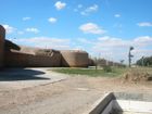
 موقع قصر البنات الأثري
 -
 مركز تجاري
 -
 حائط المدينة من العصر العباسي


مرئيات
| تقرير تلفزيوني نادر من الشرق السوري يعود لبداية الألفية. |
المصادر
- ^ "الرقة السورية... مدينة من أسماء وماء ودماء". العربي الجديد.
- ^ مانجو 1991, p. 1094.
- ^ أ ب ت ث ج ح خ د ذ ر ز س ش ص ض ط ظ ع غ ف ق ك ل م ن هـ و ي أأ أب أت أث أج أح أخ أد أذ أر أز أس أش أص أض أط أظ أع أغ أف أق أك أل أم أن أهـ أو أي بأ بب بت بث بج بح بخ بد بذ بر بز بس بش بص Meinecke, Michael (1996). Patterns of Stylistic Changes in Islamic Architecture: Local Traditions versus Migrating Artists. New York and London: New York University Press. pp. 1–22. ISBN 0-8147-5492-9. Archived from the original on 15 March 2022. Retrieved 11 March 2022.
- ^ ياقوت الحموي ، معجم البلدان، مجلد /4/ ص/208/
- ^ شمس الدين المقدسي، أحسن التقاسيم في معرفة الأقاليم، ص141
- ^ ابن الفقيه، مختصر البلدان، ط "ليون" بفرنسا سنة /1302/هـ ص/134/،
- ^ أ ب ت ث ج ح Meinecke 1995, p. 410.
- ^ Revue de l'Orient chrétien Archived 19 يونيو 2013 at the Wayback Machine, VI (1901), p. 197.
- ^ أ ب ت ث ج ح خ د ذ ر ز س ش ص ض ط ظ ع غ ف ق ك ل م ن هـ و ي أأ أب أت أث أج أح أخ أد أذ أر أز أس أش أص أض أط أظ أع أغ أف أق أك أل أم أن أهـ أو أي بأ بب بت بث بج بح بخ بد بذ بر بز بس بش بص بض بط بظ بع بغ بف بق بك بل بم Heidemann, Stefan (2006). "The History of the Industrial and Commercial Area of 'Abbāsid Al-Raqqa, Called Al-Raqqa Al-Muḥtariqa". Bulletin of the School of Oriental and African Studies. 69 (1): 33–52. doi:10.1017/S0041977X06000024. JSTOR 20181988. S2CID 162831514. Archived from the original on 15 March 2022. Retrieved 8 March 2022.
- ^ أ ب ت ث ج ح خ د ذ ر Heidemann, Stefan (2009). "Settlement Patterns, Economic Development and Archaeological Coin Finds in Bilad al-Sham: the Case of the Diyar Mudar - The Process of Transformation from the 6th to the 10th Century A.D." (PDF). Orient-Archäologie. 24: 493–516. Archived (PDF) from the original on 1 April 2022. Retrieved 11 March 2022.
- ^ Henderson, Julian (2005). Antiquity.
{{cite journal}}: CS1 maint: untitled periodical (link) - ^ "Ewer, late 12th–first half 13th century". Metropolitan Museum of Art website.
- ^ أ ب ت ث ج ح خ د ذ ر ز س ش Heidemann, Stefan (2011). "The Agricultural Hinterland of Baghdad, al-Raqqa and Samarra': Settlement Patterns in the Diyar Muḍar". In Borrut, A.; Debié, M.; Papaconstantinou, A.; Pieri, D.; Sodini, J.-P. (eds.). Le Proche-Orient de Justinien aux Abbasides: Peuplement et Dynamiques Spatiales. Turnhout: Brepols Publishers. ISBN 978-2-503-53572-2. Archived from the original on 23 September 2023. Retrieved 20 March 2022.
- ^ أ ب ت ث ج ح خ د ذ ر ز س ش ص ض ط ظ ع غ ف ق ك ل م ن Heidemann, Stefan (2005). "Numayrid ar-Raqqa: Archaeological and Historical Evidence for a 'Dimorphic State' in the Bedouin Dominated Fringes of the Fatimid Empire". Orientalia Lovaniensia Analecta: 85–110. Archived from the original on 15 August 2022. Retrieved 20 March 2022.
- ^ أ ب Ababsa, Myriam (2009). "The Shi'i Mausoleums of Raqqa: Iranian prosetylism and local significations". In Lawson, Fred H. (ed.). Demystifying Syria. London: Saqi Books. ISBN 978-0-86356-818-3. Archived from the original on 23 September 2023. Retrieved 11 March 2022.
- ^ Stefan Winter, "The Province of Raqqa under Ottoman Rule, 1535–1800" in Journal of Near Eastern Studies 68 (2009), 253–67.
- ^ Winter, Stefan (2006). "The Other Nahdah: The Bedirxans, the Millîs, and the Tribal Roots of Kurdish Nationalism in Syria". Oriente Moderno: 470–471. doi:10.1163/22138617-08603003.
- ^ أ ب ت ث ج ح خ Ababsa, Myriam (20 September 2010). "Chapitre 1. " Politique des chefs " en Jazîra et " politique des notables " à Raqqa : La naissance d'une ville de front pionnier (1865-1946)". Raqqa, territoires et pratiques sociales d'une ville syrienne. Contemporain publications. Beyrouth: Presses de l’Ifpo. pp. 25–66. ISBN 9782351592625. Archived from the original on 3 June 2018. Retrieved 12 March 2018.
- ^ أ ب ت "لمحة عن تاريخ الرقة | موسوعة جياي كورمنج ™". موسوعة جياي كورمنج ™. 14 November 2016. Archived from the original on 2 April 2019. Retrieved 4 July 2018.
- ^ Ronahi TV (6 September 2018). "The Museum Of Raqqa Struggles To Recover Following ISIS Looting". Al Shahid Witness. Archived from the original on 31 October 2018. Retrieved 7 July 2019.
- ^ معبد الحسون. "الرقة من العشيرة إلى المدينة: المخفر العثماني.. دويلات عابرة.. البعث والجهاديون (2-3)". معهد العالم للدراسات.
- ^ http://www.aljazeera.com/news/middleeast/2013/03/201334151942410812.html
- ^ "سوريا.. مقتل مسلح من "قسد" وإصابة اثنين بهجوم في ريف الرق". روسيا اليوم. 2021-03-30. Retrieved 2021-03-30.
قراءات إضافية
- Meinecke, Michael (1991). "Raqqa on the Euphrates. Recent Excavations at the Residence of Harun er-Rashid". In Kerner, Susanne (ed.). The Near East in Antiquity. German Contributions to the Archaeology of Jordan, Palestine, Syria, Lebanon and Egypt II. Amman. pp. 17–32.
{{cite book}}: CS1 maint: location missing publisher (link) - Meinecke, Michael (1412/1991). "Early Abbasid Stucco Decoration in Bilad al-Sham". In Muhammad Adnan al-Bakhit – Robert Schick (ed.). Bilad al-Sham During the 'Abbasid Period (132 A.H./750A.D.–451 A.H./1059A.D.). Proceedings of the Fifth International Conference for the History of the Bilad al-Sham 7–11 Sha'ban 1410 A.H./4–8 March 1990, English and French Section. Amman. pp. 226–237.
{{cite book}}: Check date values in:|year=(help) - Meinecke, Michael (1996). "Forced Labor in Early Islamic Architecture: The Case of ar-Raqqa/ar-Rafiqa on the Euphrates". Patterns and Stylistic Changes in Islamic Architecture. Local Traditions Versus Migrating Artists. New York, London. pp. 5–30. ISBN 0-8147-5492-9.
{{cite book}}: CS1 maint: location missing publisher (link) - Meinecke, Michael (1996). "Ar-Raqqa am Euphrat: Imperiale und religiöse Strukturen der islamischen Stadt". Mitteilungen der Deutschen Orient-Gesellschaft (128): 157–172.
- Heidemann, Stefan (2002). "Die Renaissance der Städte in Nordsyrien und Nordmesopotamien. Städtische Entwicklung und wirtschaftliche Bedingungen in ar-Raqqa und Harran von der Zeit der beduinischen Vorherrschaft bis zu den Seldschuken". Islamic History and Civilization. Studies and Texts. Leiden: Brill (40).
- Ababsa, Myriam (2002). "Les mausolées invisibles: Raqqa, ville de pèlerinage ou pôle étatique en Jazîra syrienne?". Annales de Géographie. 622: 647–664.
- Stefan Heidemann - Andrea Becker (edd.) (2003). Raqqa II – Die islamische Stadt. Mainz: Philipp von Zabern.
- Daiber, Verena; Becker, Andrea, eds. (2004). Raqqa III - Baudenkmäler und Paläste I, Mainz. Philipp von Zabern.
- Heidemann, Stefan (2005). "The Citadel of al-Raqqa and Fortifications in the Middle Euphrates Area". In Hugh Kennedy (ed.). Muslim Military Architecture in Greater Syria. From the Coming of Islam to the Ottoman Period. History of Warfare. Vol. 35. Leiden. pp. 122–150.
{{cite book}}: CS1 maint: location missing publisher (link) - Heidemann, Stefan (2006). "The History of the Industrial and Commercial Area of 'Abbasid al-Raqqa Called al-Raqqa al-Muhtariqa" (PDF). Bulletin of the School of Oriental and African Studies. 69 (1): 32–52.
وصلات خارجية
الأخبار الحالية والثورة السورية
- الرقة موقع إخباري خاص بالرقة
معلومات تاريخية وأثرية
- Inscription of ar-Raqqah on the World Heritage Tentative List
- The Citadel of ar-Raqqah - article in German
- Industrial Landscape Project - Nottingham University
- al-Raqqa at the Euphrates: Urbanity, Economy and Settlement Pattern in the Middle Abbasid Period - Jena University

- CS1 maint: untitled periodical
- Short description with empty Wikidata description
- Pages using gadget WikiMiniAtlas
- Language templates with no text displayed
- Articles with hatnote templates targeting a nonexistent page
- CS1 maint: location missing publisher
- مدن سوريا
- الهلال الخصيب
- عمارة عربية
- الرقة
- أماكن مأهولة بالسكان في الرقة
- أماكن مأهولة على نهر الفرات
- مواقع ثقافية مؤقتة في قائمة التراث العالمي لليونسكو
- مدن الجزيرة السورية