جغرافيا پاكستان
 | |
| القارة | Asia |
|---|---|
| المنطقة | South Asia ; Subcontinent |
| الإحداثيات | 30°00′N 70°00′E / 30.00°N 70.00°E |
| المساحة | Ranked 33rd |
| • الإجمالية | 881،913 km2 (340،509 sq mi) |
| • أرض | 97.14% |
| • مياه | 2.86% |
| الخط الساحلي | 1،146 km (712 mi) |
| الحدود | Total: 7،307 km (4،540.4 mi) Afghanistan: 2،430 km (1،509.9 mi) China: 559 km (347.3 mi) India: 3،323 km (2،064.8 mi) Iran: 959 km (595.9 mi) |
| أعلى نقطة | K2 8،611 m (28،251 ft) |
| أوطى نقطة | Arabian Sea 0 m (0.0 ft) |
| أطول نهر | نهر السند |
| أكبر بحيرة | Manchhar Lake |
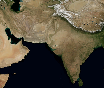
The Geography of Pakistan (أردو: جغرافیۂ پاکِستان) is a profound blend of landscapes varying from plains to deserts, forests, and plateaus ranging from the coastal areas of the Arabian Sea in the south to the mountains of the Karakoram, Hindukush, Himalayas ranges in the north. Pakistan geologically overlaps both with the Indian and the Eurasian tectonic plates where its Sindh and Punjab provinces lie on the north-western corner of the Indian plate while Balochistan and most of the Khyber Pakhtunkhwa lie within the Eurasian plate which mainly comprises the Iranian Plateau. Gilgit-Baltistan and Azad Kashmir lie along the edge of the Indian plate and hence are prone to violent earthquakes where the two tectonic plates collide.
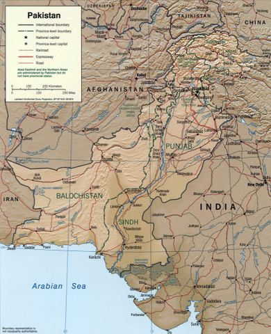
Pakistan is bordered by India to the east, Afghanistan to the northwest and Iran to the west while China borders the country in the northeast. The nation is geopolitically placed within some of the most controversial regional boundaries which share disputes and have many-a-times escalated military tensions between the nations, e.g., that of Kashmir with India and the Durand Line with Afghanistan. Its western borders include the Khyber Pass and Bolan Pass that have served as traditional migration routes between Central Eurasia and South Asia.
At 881،913 متر كيلومربع (340،509 sq mi), Pakistan is the 33rd largest country by area, little more than twice the size of the US state of California, and slightly larger than the Canadian province of Alberta. [بحاجة لمصدر]
الحدود الدولية
Pakistan shares its borders with four neighboring countries – People's Republic of China, Afghanistan, India, and Iran while Tajikistan is separated by thin Wakhan Corridor– adding up to about 6،975 km (4،334.1 mi) in length (excluding the coastal areas).
Pakistan borders Afghanistan at the Durand Line, 2،430 km (1،509.9 mi), which runs from the Hindu Kush and the Pamir Mountains. A narrow strip of Afghanistan territory called the Wakhan Corridor extends between Pakistan and Tajikistan. From the eastern tip of the Wakhan Corridor starts the Sino-Pak border between the People's Republic of China and Pakistan spanning about 510 km (316.9 mi). It carries on south-eastward and ends near the Karakoram Pass. This line was determined from 1961 to 1965 in a series of agreements between China and Pakistan and finally on 03-03-1963 both the governments, of Islamabad and Beijing, formally agreed. It is understood that if the dispute over Kashmir is resolved, the border would need to be discussed again.[1]
The boundary with Iran, 909 km (564.8 mi), was first delimited by a British commission in the same year as the Durand Line was demarcated, separating Iran from what was then British India's Baluchistan province.[1] Modern Iran has a province named Sistan va Baluchistan that borders Pakistan and has Baluchis in an ethnic majority. In 1957 Pakistan signed a frontier agreement with Iran in Rawalpindi according to which the border was officially declared and the two countries haven't had this border as a subject of serious dispute at all.
الحدود الپاكستانية-الهندية
The Northern Areas has five of the world's seventeen highest peaks along with highest range of mountains the Karakoram and Himalayas. It also has such extensive glaciers that it has sometimes been called the "Third Pole". The international border-line has been a matter of pivotal dispute between Pakistan and India ever since 1947, and the Siachen Glacier in northern Kashmir has been an important arena for fighting between the two sides since 1984, although far more soldiers have died of exposure to the cold than from any skirmishes in the conflict between their National Armies facing each other.
The Pakistan-India ceasefire line runs from the Karakoram Pass west-southwest to a point about 130 kilometers northwest of Lahore. This line, about 770 kilometers long, was arranged with United Nations (UNO) assistance at the end of the Indo-Pakistani War of 1947–48. The ceasefire line came into effect on January 1, 1949, after eighteen months of fighting between Indian forces and Pakistani forces and was last adjusted and agreed upon by the two countries according to the Shimla Agreement of July 2, 1972 between Indira Gandhi and Zulfikar Ali Bhutto. Since then, it has been generally known as the Line of Control or the (LoC).
The India–Pakistan border continues irregularly southward for about 1,280 kilometers, following the Radcliffe line, named for Sir Cyril Radcliffe, the head of the British Boundary Commission on the division of the Punjab and Bengal provinces of British India on 13 August 1947.
The southern borders are far less contentious than those in northern Pakistan (Kashmir). The Thar Desert in the province of Sindh is separated in the south from the salt flats of the Rann of Kachchh (Kutch) by a boundary that was first delineated in 1923–24. After independence and dissolution of Empire, Independent and free Pakistan contested the southern boundary of Sindh, and a succession of border incidents resulted. They were less dangerous and less widespread, however, than the conflict that erupted in Kashmir in the Indo-Pakistani War of August 1965 started with this decisive core of issues. These southern hostilities were ended by British mediation during Harold Wilson's era, and both sides accepted the award of the Indo-Pakistan Western Boundary Case Tribunal designated by the UN secretary general himself. The tribunal made its award on February 19, 1968; delimiting a line of 403 kilometers that was later demarcated by joint survey teams, Of its original claim of some 9,100 square kilometers, Pakistan was awarded only about 780 square kilometers. Beyond the western terminus of the tribunal's award, the final stretch of Pakistan's border with India is about 80 kilometers long, running east and southeast of Sindh to an inlet of the Arabian Sea.
المطالب البحرية
- Contiguous zone
- 12 ميل بحري (22 km; 14 mi)
- Continental shelf
- 350[2] ميل بحري (650 km; 400 mi), or to the edge of the continental margin
- Exclusive economic zone
- 290،000 km2 (110،000 sq mi)
- Territorial sea
- 12 ميل بحري (22 km; 14 mi)
الأقاليم الجغرافية
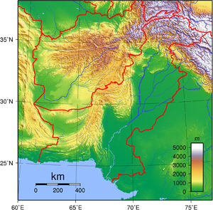
Pakistan is divided into three major geographic areas: the northern highlands; the Indus River plain, with two major subdivisions corresponding roughly to the provinces of Punjab and Sindh; and the Balochistan Plateau. Some geographers designate additional major regions. For example, the mountain ranges along the western border with Afghanistan are sometimes described separately from the Balochistan Plateau, and on the eastern border with India, south of the Sutlej River, the Thar Desert may be considered separately from the Indus Plain. Nevertheless, the country may conveniently be visualized in general terms as divided in three by an imaginary line drawn eastward from the Khyber Pass and another drawn southwest from Islamabad down the middle of the country. Roughly, then, the northern highlands are north of the imaginary east-west line; the Balochistan Plateau is to the west of the imaginary southwest line; and the Indus Plain lies to the east of that line.


تنقسم باكستان إلى خمسة أقاليم تضاريسية رئيسية وهي:
1- المرتفعات الشمالية والغربية.
2- سهل البنجاب.
3 - سهل السند.
4- سهل بلوخستان.
5- صحراء ثار. وتبلغ جملة مساحة باكستان 796,095كم².
المرتفعات الشمالية والغربية
تغطي الجبال معظم الأنحاء الشمالية والغربية من باكستان. ويعتبر جبل ك2، أعلى ثاني قمة في العالم، ويبلغ ارتفاعه 8611م فوق مستوى سطح البحر، ويقع في نواحي منطقة كشمير الواقعة تحت سيطرة باكستان. وليس هناك قمة تفوق قمة جبل ك2 في الارتفاع سوى قمة جبل إيفرست. وتتقاطع الممرات الجبلية في العديد من النقاط والشعاب في أعلى سفوح القمم الوعرة الشائكة في جبل ك2، وأشهر هذه الممرات الجبلية هو ممر خيبر، الذي يربط تخوم باكستان الشمالية بأفغانستان. انظر: خيبر، ممر.
سهلا البنجاب والسند
يحتل إقليم سهلي البنجاب والسند معظم الأنحاء الشرقية للبلاد ويعتبر من السهول الطينية (يتكون السهل الطيني من التربة التي تترسب بوساطة الأنهار). وتُرْوى منطقة البنجاب في الشمال بوساطة نهر السند إضافة إلى أربعة من روافده، وهي شيناب، وجهيلم ورافي، وسوتلج. وتمتزج المياه المتجمعة من هذه الروافد الأربعة بمياه نهر السند في الأنحاء الشرقية من أواسط باكستان. ومن الجنوب من نقطة التقاء الروافد الأربعة بنهر السند يزداد نهر السند اتساعـًا. ثم يسير متدفقـًا حتى يصب في بحر العرب مخترقـًا سهل السند. وبفضل قيام أنظمة الري الشامل فقد أصبحت سهول البنجاب والسند من الأقاليم الزراعية الخصيبة.
سهل بلوشستان
يقع في الناحية الجنوبية الغربية من باكستان. ومعظم الأنحاء في هذا السهل يسودها الجفاف وتأخد طابعـًا صخريـًا. كما يتميز هذا الإقليم بندرة وجود الغطاء النباتي.
صحراء ثار
يقع هذا الإقليم في الشمال الشرقي من باكستان، ويمتد حتى يصل إلى الأجزاء الشمالية الغربية من الهند. ومعظم المساحات الصحراوية في هذا الإقليم هي مساحات رملية جرداء مقفرة، إلا أن مشاريع الري التي تم إنشاؤها جعلت بعض المناطق الصحراوية الواقعة بالقرب من نهر السند صالحة للزراعة.انظر: ثار، صحراء.
المناخ
الطقس البارد المشمس يعم منطقة المرتفعات الشمالية والغربية من الباكستان. ويعتبر مناخ الباكستان جافًا عمومًا مع معدل أمطار 25سم. يتميز المناخ في باكستان بالجفاف في معظم أنحاء البلاد، إضافة إلى أنه حار في الصيف وبارد في الشتاء. ويبلغ معدل هطول الأمطار نحو 25 سم في العام، إلا أن درجة هطول الأمطار تتباين تباينـًا هائلاً من سنة إلى أخرى، حيث يمتد الجفاف لفترات طويلة، ثم تهطل الأمطار الغزيرة المصحوبة بالعواصف مما يؤدي إلى ارتفاع منسوب الأنهار حتى تفيض وتغمر أنحاء الريف.
تهطل معظم الأمطار في الفترة الواقعة بين شهري يوليو وسبتمبر حينما تهب على باكستان الرياح الصيفية المعروفة باسم الرياح الموسمية (المونسون). وتهطل معظم الأمطار في الجزء الشرقي من البنجاب حيث يبلغ معدل هطول الأمطار أكثر من 50 سم في العام، أما الأجزاء الجنوبية الغربية من باكستان فهي أكثر الأنحاء جفافـًا في البلاد. والعديد من الأنحاء الواقعة في سهل بلوخستان يقل فيها معدل هطول الأمطار عن 13سم في العام.
وتتباين درجات الحرارة في أنحاء البلاد المختلفة حيث تكون الأقاليم الجبلية هي أكثرها برودة في الطقس. ويبلغ متوسط درجة الحرارة في الصيف في شمال وشمال شرقي باكستان 24°م، وفي الشتاء تبلغ درجة الحرارة في منطقة البنجاب الواقعة شرقي باكستان 32°م في الصيف، ونحو 13°م في الشتاء. وفي سهل بلوخستان الواقع في غربي باكستان يبلغ متوسط درجة الحرارة 27°م في الصيف. أما في الشتاء فإن متوسط درجة الحرارة يقل عن 4°م. أما إقليم الساحل الذي يقع في جنوب باكستان فإنه يتميز بالمناخ المعتدل والمشبع بالرطوبة في معظم فترات السنة، ويتراوح متوسط درجة الحرارة ما بين 19°م في الشتاء ونحو 30°م في الصيف.
Water resources
Hydrological power is a renewable resource which benefits Pakistan a lot. After the Indus Water Treaty on 1960 World Bank decided that River Sutlej, Ravi and Beas water will be used by India and River Indus, Jhelum and Chenab water will be used by Pakistan. Pakistan was told to build two dams, one tarbela and second Mangla, five barrages, eight link canals, and one gated siphon. For this, India was told to participate 60%, whereas Pakistan, 40%. Pakistan is considering to develop wind turbines to fulfill the demand for electricity. Solar power is now slowly flourishing but it is still installed on a small scale.
Pakistan largest river is known as the Indus River which flows from Tibet/China and enters Pakistan through Gilgit Baltistan. The Indus River system is divided into two plains. The Upper Indus Plain starts from northern Pakistan and ends up at Mithankot. The Indus has tributaries on both western and eastern side. The Indus' eastern tributaries are the Jhelum, Chenab, Sutlej, Ravi and Beas. These four rivers flow in Punjab and meet at Panjnad where they are known as Panjnad river. The Indus' western tributaries are the Swat, Kabul, Kurrram, Tochi, Gomal, Zhob rivers. These rivers join the Indus at KPK. At Mithankot these rivers finally meet with the River Indus. After this the Indus flows alone through the Lower Indus Plain. Lower Indus Plain starts from Mithankot up to Thatta where the Indus meets with the Arabian Sea. This place is also known as Indus Delta.
Fuel resources
Pakistan has extensive energy resources, including fairly sizable natural gas reserves, petroleum oil reserves, coal fields and large hydropower potential.
Agriculture
About 26% of Pakistan's total land area is under cultivation and is watered by one of the largest irrigation systems in the world. The most important crops are tobacco, cotton, wheat, rice, sugarcane, maize, sorghum, millets, pulses, oil seeds, barley, fruits and vegetables, which together account for more than 75% of the value of total crop output.[3]
Fishery
Fishery and fishing industry plays an important role in the national economy of Pakistan. With a coastline of about 1046 km, Pakistan has enough fishery resources that remain to be fully developed. It is also a major source of export earning.
Forestry
About only 4.1% of land in Pakistan is covered with forests. The forests of Pakistan are a main source of food, lumber, paper, fuel wood, latex, medicine as well as used for purposes of wildlife conservation and Eco tourism.
Mining
The Salt Range in the Potwar Plateau has large deposits of rock salt. Pakistan has extensive mineral resources, including fairly sizable reserves of gypsum, limestone, chromites, iron ore, rock salt, silver, gold, precious stones, gems, marbles, tiles, copper, sulfur, fire clay and silica sand.
Environment and conservation
The environmental issues is a great problem for the nature and nation of Pakistan and has been disturbing the balance between economic development and environmental protection. As Pakistan is a large importer of both exhaustible and renewable natural resources and a large consumer of fossil fuels, the Ministry of Environment of Government of Pakistan takes responsibility to conserve and protect the environment.
Current issues: water pollution from raw sewage, industrial wastes, and agricultural runoff; limited natural fresh water resources; a majority of the population does not have access to potable water; deforestation; soil erosion; desertification.
Natural disasters
Pakistan is subject to frequent earthquakes which are often severe (especially in north and west) and severe flooding along the Indus after heavy rains (July and August). Landslides are common in the northern mountains.
Protected areas
There are 15 national parks, 72 wildlife sanctuaries, 66 game reserves, 9 marine and littoral protected areas, 19 protected wetlands and a number of other protected grasslands, shrublands, woodlands and natural monuments.
International agreements
Pakistan is a party to several international agreements related to environment and climate, the most prominent among them are:
| Treaties and Agreements | |
|---|---|
| Specific Regions and Seas | Law of the Sea, Ship Pollution (MARPOL 73/78) |
| Atmosphere and Climate | Climate Change, Ozone Layer Protection, Nuclear Test Ban |
| Biodiversity, Environment, and Forests | Desertification, Endangered Species, Environmental Modification, Wetlands, Marine Life Conservation |
| Wastes | Hazardous Wastes |
| Rivers | Indus Waters Treaty |
Suffix of regions and towns
Parts of region and settlement names:
- -abad (أردو: ـ آباد ) means settled place. Example: Islamabad, Faisalabad.
- -dera (أردو: ڈیره ـ ) means meeting place. Example: Dera Ismail Khan.Dera Ghazi khan
- -garh (أردو: ـ گڑھ ) means fort or settlement. Example: Islamgarh.
- -goth (أردو: ـ گوٹھ ) means settlement or town. Example: Yousuf Goth.
- -istan (أردو: ـستان ) means land. Example: Baltistan, Balochistan.
- Khel or -khel (أردو: خیل ) denotes a Pashtun sub-tribe. Example: Darra Adam Khel (أردو: درہ آدم خیل).
- -kot (أردو: ـکوٹ ) means settlement or town. Example: Islamkot, Sialkot.
- -nagar (أردو: ـ نگر ) means house. Example: Islamnagar.
- -pur (أردو: ـ پُور ) means settlement or town. Example: Nasarpur.
- -wal (أردو: ـوال ) means settlement or town. Example: Khanewal.
- -wala (أردو: ـوالا ) means settlement or town. Example: Gujranwala.
- -tando (أردو: ٹنڈو ـ) means settlement or town. Example: Tando Allahyar.
انظر أيضاً
- Extreme points of Pakistan
- Geology of Pakistan
- Zomia (geography)
- Fisheries Research and Training Institute, Lahore Pakistan
References
- ^ أ ب "Pakistan: Geography". US Country Studies. Retrieved 2008-05-05.
- ^ https://www.youtube.com/watch?v=u8aCGEh0gds
- ^ Environment of Pakistan pg213."Major crop output" line 13
وصلات خارجية
- Pages using gadget WikiMiniAtlas
- Coordinates on Wikidata
- Pages using infobox country geography with unknown parameters
- Articles containing أردو-language text
- Pages using Lang-xx templates
- مقالات ذات عبارات بحاجة لمصادر
- Articles with hatnote templates targeting a nonexistent page
- Pages with empty portal template
- جغرافيا پاكستان


