پروڤنس-ألپ-كوت دازور
Provence-Alpes-Côte d'Azur
Provença-Aups-Còsta d'Azur (أوكسيتان) | |
|---|---|
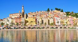 View of Menton on the French Riviera | |
 | |
| الإحداثيات: 44°00′N 6°00′E / 44.000°N 6.000°E | |
| Country | |
| Prefecture | Marseille |
| Departments | |
| الحكومة | |
| • President of the Regional Council | Renaud Muselier (LR) |
| المساحة | |
| • الإجمالي | 31٬400 كم² (12٬100 ميل²) |
| ترتيب المساحة | 10th |
| التعداد (2015) | |
| • الإجمالي | 5٬007٬977 |
| • الكثافة | 160/km2 (410/sq mi) |
| صفة المواطن | Provençals |
| منطقة التوقيت | UTC+01:00 (CET) |
| • الصيف (التوقيت الصيفي) | UTC+02:00 (CEST) |
| ISO 3166 code | FR-PAC |
| GDP (2012)[1] | Ranked 3rd |
| Total | €142.4 billion (US$183.1 bn) |
| Per capita | €28,861 (US$37,121) |
| NUTS Region | FR8 |
| الموقع الإلكتروني | maregionsud.fr |
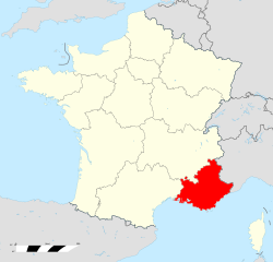
پروڤنس-ألپ-كوت دازور (Provence-Alpes-Côte d'Azur ؛ النطق الفرنسي: [pʁɔvɑ̃s‿alp kot d‿azyʁ]؛ قالب:Lang-oci؛ [pɾuˈvɛnso̞ ˈawps ˈkɔsto̞ daˈzyɾ]؛ إيطالية: Provenza-Alpi-Costa Azzurra؛ commonly shortened to PACA؛ وتـُعرف أيضاً بإسم Région Sud) هي واحدة من 18 منطقة تكوِّن فرنسا، the far southeastern on the mainland. Its prefecture is Marseille. The region is roughly coterminous with the former French province of Provence, with the addition of the following adjacent areas: the former papal territory of Avignon, known as Comtat Venaissin; the former Sardinian-Piedmontese county of Nice, whose coastline is known in English as the French Riviera and in French as the Côte d'Azur; and the southeastern part of the former French province of Dauphiné, in the French Alps. Previously known by the acronym PACA, the region adopted the name Région Sud as a commercial name or nickname in December 2017.[2] 5,007,977 people live in the region according to the 2015 census.
It encompasses six departments in Southeastern France: Alpes-de-Haute-Provence, Alpes-Maritimes, Bouches-du-Rhône, Hautes-Alpes, Var and Vaucluse. It is bounded to the east by the France-Italy border, to the south by the Mediterranean Sea and by the Principality of Monaco, to the north by Auvergne-Rhône-Alpes, and to the west by Occitanie, with the Rhône river marking its westernmost border. The region logotype displays the coat of arms created in the 1990s and which combines the coats of arms of the old provinces making up Provence-Alpes-Côte d'Azur. The region's economy is the third largest in France, just behind Île-de-France and Auvergne-Rhône-Alpes. Its GDP in 2012 was €142.4 billion (US$183.1 billion) while its per capita GDP was €28,861 ($US 37,121).
الأقاليم
Provence-Alpes-Côte d'Azur is divided into 6 departments. These are Alpes-de-Haute-Provence, Hautes-Alpes, Alpes-Maritimes, Bouches-du-Rhône, Var and Vaucluse.
| Department | Area | Population | Prefecture | Sub-prefecture(s) | Population density | |
|---|---|---|---|---|---|---|
| 04 | Alpes-de-Haute-Provence | 6،944 km2 (2،681 sq mi) | 161٬241 | Digne-les-Bains | Barcelonnette, Castellane and Forcalquier | 23/km2 (60/sq mi) |
| 05 | Hautes-Alpes | 5،549 km2 (2،142 sq mi) | 139٬554 | Gap | Briançon | 24/km2 (62/sq mi) |
| 06 | Alpes-Maritimes | 4،299 km2 (1،660 sq mi) | 1٬084٬428 | Nice | Grasse | 252/km2 (650/sq mi) |
| 13 | Bouches-du-Rhône | 5،112 km2 (1،974 sq mi) | 1٬984٬784 | Marseille | Aix-en-Provence, Arles and Istres | 385/km2 (1،000/sq mi) |
| 83 | Var | 5،973 km2 (2،306 sq mi) | 1٬021٬669 | Toulon | Brignoles and Draguignan | 196/km2 (510/sq mi) |
| 84 | Vaucluse | 3،566 km2 (1،377 sq mi) | 546٬314 | Avignon | Apt and Carpentras | 151/km2 (390/sq mi) |
المدن الرئيسية
أكبر المدن في المنطقة هي مرسيليا، نيس، تولون، واكس-ان-پروڤنس, كل منها تعدادها يتعدى 100,000 نسمة في تعداد 1999. أكثر الأجزاء ثراءً في المنطقة هو منطقة نيس الحضرية.
- Aix-en-Provence – 142,743
- Antibes (includes Juan-les-Pins) – 76,994
- Arles – 52,729
- Aubagne – 46,423
- Avignon – 90,194
- Cannes – 73,603
- Draguignan – 38,258
- Fréjus – 52,389
- Grasse – 51,580
- Hyères – 56,275
- La Seyne-sur-Mer – 64,903
- Le Cannet – 40,940
- Mandelieu-la-Napoule – 22,714
- Marseille – 861,636
- Martigues – 76,471
- Mougins – 19,703
- Nice – 343,875
- Toulon – 167,729
- Villeneuve-Loubet – 14,427
وهناك العديد من المدن والبلدات الشهيرة ولكن صغيرة على طول الريڤييرا الفرنسية.
جغرافيا
This region has a total area of 31،400 km2 (12،100 sq mi). It has a wide variety of landscapes, from the Alps mountains to plains and coastal areas like Nice and Marseille, which form the majority of the land area. The region has a Mediterranean coastline on the south, on which the majority of its population lives. It borders Italy (Liguria and Piedmont) to the east, Monaco (Fontvieille, La Colle, La Rousse, Larvotto, Les Moneghetti, Les Révoires, Saint Michel) in the south-east, and the French regions of Auvergne-Rhone-Alpes to the north and Occitanie to the west. The Rhône, Durance, Var and Arc rivers run through the region. The borders were unaffected by the 2016 French regional reforms.
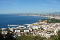
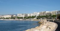
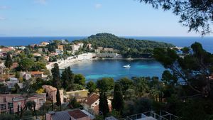
This region is famous for the Côte d'Azur (French Riviera), which spans the coastal cities of Nice, Saint-Laurent-du-Var, Antibes, Juan-les-Pins, Cannes, Mandelieu-la-Napoule, Fréjus, Saint-Raphaël, Sainte-Maxime and Saint-Tropez; and on the Rhône river, the city of Avignon which is surrounded by medieval stone ramparts.
الحكم المحلي والسياسة
The Regional Council of Provence-Alpes-Côte d'Azur is the legislative body of the region. The President of the Regional Council has been Renaud Muselier (LR) since 2017.
المناحي السياسية
In the recent years Les Républicains have gained strong support in the region and following the 2015 departmental elections, they control the region, which had been narrowly controlled by the Parti Socialiste with Michel Vauzelle previously.
The French Communist Party historically had several strongholds in the region from the 1920s onward, including Aubagne, Draguignan, La Ciotat, Beausoleil, Martigues, Gardanne, Arles and some suburbs of Marseille. Though not enough to win the regional elections, the party usually received about 10% of the vote. Beginning with 2002 this declined to 4% and by 2012, dropped below 2%.
The main competition seen in the politics of this region is between Les Républicains and the Parti Socialiste (PS), both deferring in its opinions. According to the most recent elections, the political tendencies are as follows-
| Élection / collectivités | Les Républicains (centre-right) | Parti Socialiste (centre-left) |
|---|---|---|
| Presidential Election (2012) (2nd tour) | 57.62% (Nicolas Sarkozy) (LR) | 42.38% (François Hollande) (PS) |
| Regional Councils | 51 (LR-NC-DVD-FN) | 72 (PS-PRG-Verts-PCF-DVG) |
| General Councils | 5 | 1 |
| Deputies | 27 | 15 |
| Senators | 13 | 9 |
الاقتصاد

The regional income per capita is close to the French national average. Income inequality however is higher than in other regions: the region is ranked 4th by percent of population living above the poverty line. The region is ranked third by GDP. Between 2007 and 2011, the region registered an average annual growth rate of 1.6% of GDP (Eurostat), close to the national average annual growth rate of 1.5%. Representing 7.2% of the national GDP over the period, the region is an important economic powerhouse.
In 2013, the region was responsible for 7.4% of national employment, with an employment rate of 89.2%. The region's employment success has a main characteristic: a higher concentration of elderly people than in the rest of France (respectively 27.1% and 24.1% in 2013).
الثقافة
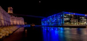
The region is one of the most visited of France, and has therefore many well-known museums, mostly in Marseille: the Museum of European and Mediterranean Civilisations, the Musée Cantini, the Musée Grobet-Labadié, the Marseille History Museum, the Musée des beaux-arts de Marseille, the Musée de la Faïence de Marseille and the Muséum d'histoire naturelle de Marseille are some of the tourist spots of the city. However, other museums are internationally recognised, like the Musée Matisse, the Musée d'art moderne et d'art contemporain, the Musée Marc Chagall, the Musée international d'Art naïf Anatole Jakovsky, the Musée des Beaux-Arts de Nice, the Musée National du Sport and the Muséum d'histoire naturelle de Nice.
الهامش
وصلات خارجية
Provence-Alpes-Cote d'Azur at the Open Directory Project
- Conseil régional Provence-Alpes-Côte d'Azur Official website
- NotreProvence.fr Discover the Provence on NotreProvence.fr (fr)
- Pages using gadget WikiMiniAtlas
- Short description is different from Wikidata
- Articles containing أوكسيتان (بعد 1500)-language text
- Coordinates on Wikidata
- Pages with plain IPA
- Articles containing إيطالية-language text
- Pages using Lang-xx templates
- پروڤنس-ألپ-كوت دازور
- مناطق فرنسا
- أقاليم التصنيف الثاني في الاتحاد الأوروپي


