ألپ پروڤانس العليا (إقليم فرنسي)
Alpes-de-Haute-Provence
Aups d'Auta Provença (أوكسيتان) | |
|---|---|
   | |
 Flag  Coat of arms | |
 Location of Alpes-de-Haute-Provence in France | |
| الإحداثيات: 44°0′N 6°10′E / 44.000°N 6.167°E | |
| Country | France |
| Region | Provence-Alpes-Côte d'Azur |
| Prefecture | Digne-les-Bains |
| Subprefectures | Barcelonnette Castellane Forcalquier |
| الحكومة | |
| • President of the Departmental Council | Éliane Barreille[1] (LR) |
| المساحة | |
| • الإجمالي | 6٬925 كم² (2٬674 ميل²) |
| التعداد (يناير 2019) | |
| • الإجمالي | 164٬308 |
| • الترتيب | 95th |
| • الكثافة | 24/km2 (61/sq mi) |
| منطقة التوقيت | UTC+1 (CET) |
| • الصيف (التوقيت الصيفي) | UTC+2 (CEST) |
| Department number | 04 |
| أكبر مدينة | مانوسك |
| Arrondissements | 4 |
| Cantons | 15 |
| Communes | 198 |
| ^1 French Land Register data, which exclude estuaries and lakes, ponds and glaciers larger than 1 km2 | |
ألب دي هوت بروفانس Alpes-de-Haute-Provence هو إقليم في منطقة بروڤنس ألپ كوت دازور . يبلغ عدد سكانه حوالي 153000 نسمة. ويحده Alpes-Maritimes and Italy to the east, Var to the south, Vaucluse to the west, Drôme and Hautes-Alpes to the north. Formerly part of the province of Provence, it had a population of 164,308 in 2019,[2] which makes it the 94th most populated French department.
Alpes-de-Haute-Provence's main cities are Digne-les-Bains (prefecture), Manosque, Sisteron, Barcelonnette, Castellane and Forcalquier. Inhabitants are called the Bas-Alpins (masculine) or Bas-Alpines (feminine) in reference to the department's former name, Basses-Alpes, which was in use until 1970. Although the prefecture is Digne-les-Bains, the largest city is Manosque. Alpes-de-Haute-Provence's INSEE and postal code is 04.
الجغرافيا
The departmental can be divided into three zones depending on the terrain, climate, population and economy:
- the plateaux, hills and valleys of Haute-Provence, which comprise one-third of the area but two-thirds of the population and the most important cities of the department with almost all of the economic activity apart from mountain tourism. The valley of the Durance, the artery of the department, cuts the rest of the department into two-halves:
- the Lower Alps: an intermediate mountain area with valleys and very remote villages
- the High Alps: including the valleys of Ubaye, Blanche, and the high Verdon (upstream of Colmars-les-Alpes) where the economy is built around mountain tourism (skiing). In the Haute-Ubaye, the mountain peaks exceed 3000 m above sea level and all the passes are close to or above 2000 m in altitude. In this part of the department is one of the highest roads in Europe: the main road D64 reaches an altitude of 2802 m near the Col de la Bonette (2715 m) and connects the region of Barcelonnette to the Tinée and Vésubie valleys.
The relief of the land compartmentalises the region: the enclosed valleys are difficult to access, so dividing the country into as many local areas which communicate very little with the outside. In 1877, 55 communes only had access to trails or mule paths.[3]
The seismic hazard is moderate (zone 3) to medium (zone 4) with different faults such as the Durance located in the department.[4]
The main cities are Manosque, Digne-les-Bains, Sisteron, Château-Arnoux-Saint-Auban, Oraison, Forcalquier, Les Mées, Pierrevert, Villeneuve, Sainte-Tulle, Gréoux-les-Bains, Barcelonnette and Castellane.
الهيدرولوجيا

The main river is the Durance which runs in the west of the department. It is in the Durance valley that the most important traffic routes are found: the A51 autoroute and the railway main line. Almost all of the department is in the watershed of the Durance except for the extreme south-east (the cantons of Annot and Entrevaux) which are drained by the Var.
The main tributaries of the Durance in the department are the Ubaye, the Bléone, the Asse, the Verdon on the left bank, the Buëch, the Jabron, and the Largue on the right bank.
The Durance and its tributaries have a torrential character, with a transition between the snow regime of the high valleys and the Mediterranean rainfall regime in the lower mountains and below. The summer low water levels are severe and violent floods occur when heavy rains fall which is often in autumn. The Durance, Verdon, Bléone and Buëch have had the construction of several dams and the diversion of parts of the river for irrigation and power generation in the 20th century.
المناخ
The climate of the Alpes-de-Haute-Provence department is a Mediterranean climate degrading by altitude and latitude. In fact, while in the lower valleys and flat lands of Haute-Provence an inland Mediterranean climate prevails, by contrast in the hills it is more mixed with the valley of the Ubaye characteristic of the inner Alps, with a marked continentality: winters are very harsh with stormy summers. In between, the two influences mingle in the area of the Lower Alps. The characteristics of both climate trends are found throughout the department to a greater or lesser extent:
- dry air and little fog (less than 20 days per year)
- infrequent rainfall (less than 90 days per year) but heavy (650 to 1500 mm per year)
- frequent thunderstorms in the mountains in summer
- High sunshine hours in all seasons (2550 to 2850 hours per year)
- high thermal amplitudes, diurnal (over 10 °C) and annual (18 °C)
- fresh and bright winters
- very hot summers barely tempered by altitude.
Haute-Provence is therefore very interesting for European astronomers looking for a partly cloudy night sky and untouched by light pollution. Many amateur observatories have been built and the Observatoire de Haute-Provence is one of the largest observatories in continental Europe. It is an active astronomy research centre.
| بيانات المناخ لـ Saint Auban | |||||||||||||
|---|---|---|---|---|---|---|---|---|---|---|---|---|---|
| الشهر | ينا | فب | مار | أبر | ماي | يون | يول | أغس | سبت | أكت | نوف | ديس | السنة |
| متوسط القصوى اليومية °س (°ف) | 9.0 (48.2) |
10.8 (51.4) |
14.6 (58.3) |
17.2 (63.0) |
21.7 (71.1) |
26.1 (79.0) |
29.9 (85.8) |
29.3 (84.7) |
24.4 (75.9) |
19.0 (66.2) |
13.0 (55.4) |
9.2 (48.6) |
18.7 (65.7) |
| المتوسط اليومي °س (°ف) | 4.3 (39.7) |
5.4 (41.7) |
8.7 (47.7) |
11.3 (52.3) |
15.5 (59.9) |
20.0 (68.0) |
22.7 (72.9) |
22.3 (72.1) |
18.2 (64.8) |
13.6 (56.5) |
8.3 (46.9) |
4.9 (40.8) |
12.9 (55.2) |
| متوسط الدنيا اليومية °س (°ف) | −0.4 (31.3) |
0.0 (32.0) |
2.8 (37.0) |
5.4 (41.7) |
9.2 (48.6) |
12.8 (55.0) |
15.5 (59.9) |
15.3 (59.5) |
11.9 (53.4) |
8.2 (46.8) |
3.6 (38.5) |
0.6 (33.1) |
7.1 (44.8) |
| متوسط تساقط الأمطار mm (inches) | 45.0 (1.77) |
37.1 (1.46) |
41.7 (1.64) |
67.1 (2.64) |
63.6 (2.50) |
53.0 (2.09) |
34.3 (1.35) |
55.8 (2.20) |
79.1 (3.11) |
84.2 (3.31) |
73.0 (2.87) |
61.0 (2.40) |
694.9 (27.36) |
| Average precipitation days (≥ 1 mm) | 5.2 | 4.6 | 5.2 | 8.0 | 7.5 | 5.9 | 4.1 | 4.6 | 5.8 | 7.6 | 6.4 | 6.4 | 71.3 |
| Mean monthly ساعات سطوع الشمس | 170 | 187 | 232 | 225 | 260 | 302 | 343 | 310 | 247 | 191 | 159 | 148 | 2٬774 |
| Source: Meteorological data for Saint Auban – 461m altitude, from 1981 to 2010 January 2015 (in فرنسية) | |||||||||||||
السكان
|
| ||||||||||||||||||||||||||||||||||||||||||||||||||||||||||||||||||||||||||||||||||||
| Sources:[5][6] | |||||||||||||||||||||||||||||||||||||||||||||||||||||||||||||||||||||||||||||||||||||
The population was once fairly evenly distributed in the territory, including in the mountainous areas where mountain agriculture was well developed. From the middle of the 19th century, however, it began to decline due to a strong rural exodus. There were more than 150,000 inhabitants in 1850 but it fell to less than 100,000 after the First World War. It was not until 1960 that the trend changed upwards quite strongly from less than 90,000 in 1954 to nearly 140,000 in 1999 and 162,565 in 2016. However, if this figure is close to the number of inhabitants the department had 150 years earlier, the distribution and activity of the population are very different. The population is now concentrated in the valley of the Durance and the South West of the department, and agriculture employs less than ever before. Services, mainly tourism and local services, is now the main industry.
The population of the department is sightly similar to Guam.
The department has never really developed: in 1870 there were 27 small mines (one lead, four oil shale and 22 lignite).[7]
الأحياء والكانتونات
| Arrondissement | Canton | # of communes |
|---|---|---|
| Barcelonnette | Barcelonnette | 11 |
| Le Lauzet-Ubaye | 5 | |
| Castellane | Allos-Colmars | 6 |
| Annot | 7 | |
| Castellane | 7 | |
| Entrevaux | 6 | |
| Saint-André-les-Alpes | 6 | |
| Digne-les-Bains | Barrême | 8 |
| Digne-les-Bains-Est | 4 | |
| Digne-les-Bains-Ouest | 10 | |
| La Javie | 6 | |
| Les Mées | 6 | |
| Mézel | 8 | |
| Moustiers-Sainte-Marie | 3 | |
| Riez | 9 | |
| Seyne | 8 | |
| Valensole | 4 | |
| Forcalquier | Banon | 9 |
| Forcalquier | 10 | |
| Manosque-Nord | 3 | |
| Manosque-Sud-Est | 3 | |
| Manosque-Sud-Ouest | 3 | |
| La Motte-du-Caire | 13 | |
| Noyers-sur-Jabron | 7 | |
| Peyruis | 4 | |
| Reillanne | 8 | |
| Saint-Étienne-les-Orgues | 8 | |
| Sisteron | 5 | |
| Turriers | 7 | |
| Volonne | 9 |
التعداد السكاني
السياسة
| Party | seats | |
|---|---|---|
| • | Socialist Party | 12 |
| • | Miscellaneous Left | 6 |
| Miscellaneous Right | 6 | |
| • | French Communist Party | 3 |
| • | Citizen and Republican Movement | 1 |
| Union for a Popular Movement | 2 | |
السياحة
- The town of Sisteron with its ancient citadel and narrow streets
- The Gorge of Verdon (Europe's Grand Canyon)
- Digne-les-Bains Hot-spa town
- Moustiers-Sainte-Marie Pottery
- Forcalquier Cathedral
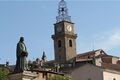
Digne-les-Bains, The prefecture of the Alpes-de-Haute-Provence department
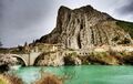
Rocher de La Baume
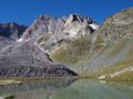
The Aiguille de Chambeyron and the Marinet Lake in the Ubaye Valley


.jpg&filetimestamp=20230601010325&)
.jpg&filetimestamp=20230601010319&)


انظر أيضاً
- Cantons of the Alpes-de-Haute-Provence department
- Communes of the Alpes-de-Haute-Provence department
- Arrondissements of the Alpes-de-Haute-Provence department
المصادر
وصلات خارجية
- Alpes-de-Haute-Provence at the Open Directory Project
- (بالفرنسية) Conseil général website
- Abbeys in the Alps (fr. with translator)
- (بالفرنسية) Prefecture website
- (إنگليزية) Préfecture web-site in English
- (بالفرنسية) Detailed information in French
- Sisteron guide
- ^ "Répertoire national des élus: les conseillers départementaux". data.gouv.fr, Plateforme ouverte des données publiques françaises (in الفرنسية). 4 May 2022.
- ^ Populations légales 2019: 04 Alpes-de-Haute-Provence, INSEE
- ^ Raymond Collier, Haute-Provence monumental and artistic, Digne, Imprimerie Louis Jean, 1986, 559 pages, p. 420 (in فرنسية)
- ^ Decree on seismic risk in the department of Alpes-de-Haute-Provence, 2010 (in فرنسية)
- ^ "Historique des Alpes-de-Haute-Provence". Le SPLAF.
- ^ "Évolution et structure de la population en 2016". INSEE.
- ^ Irène Magnaudeix, Sitting Stone, Moving Stone: usage and representation of stone by the inhabitants of Haut-Vançon, Mane, Les Alpes de Lumière, Forcalquier, 2004. ISBN 978-2-906162-73-0, p 124 (in فرنسية)
- Pages using gadget WikiMiniAtlas
- صفحات بها مخططات
- Short description is different from Wikidata
- Articles containing أوكسيتان (بعد 1500)-language text
- Coordinates on Wikidata
- Articles with فرنسية-language sources (fr)
- بذرة فرنسا
- أقاليم فرنسا
- Alpes-de-Haute-Provence
- دول وأراضي تأسست في 1790
- CS1 الفرنسية-language sources (fr)