برست، فرنسا
Brest | |
|---|---|
Subprefecture and commune | |
     De haut en bas, de gauche à droite : la tour Tanguy lors des fêtes maritimes, le château de Brest face à la rade. le pont de Recouvrance ; le téléphérique de Brest ; les tours du portail ; le Götheborg III dans le port de Brest. | |
 Flag  Coat of arms | |
Location of Brest خطأ: الوظيفة "main" غير موجودة. | |
 Brest  Brest | |
| الإحداثيات: 48°23′N 4°29′W / 48.39°N 4.49°W | |
| البلد | فرنسا |
| المنطقة | بريتاني |
| الإقليم | Finistère |
| الدائرة | Brest |
| الكانتون | Brest-1, 2, 3, 4 and 5 |
| بينالتجمعات | Brest Métropole |
| الحكومة | |
| • العمدة (2020–2026) | François Cuillandre[1] (PS) |
| المساحة 1 | 49٫51 كم² (19٫12 ميل²) |
| التعداد (يناير 2019) | 139٬926 |
| • الكثافة | 2٬800/km2 (7٬300/sq mi) |
| صفة المواطن | Brestois (masculine) Brestoise (feminine) |
| منطقة التوقيت | UTC+01:00 (CET) |
| • الصيف (التوقيت الصيفي) | UTC+02:00 (CEST) |
| INSEE/الرمز البريدي | 29019 /29200 |
| المنسوب | 0–103 m (0–338 ft) (avg. 34 m أو 112 ft) |
| الموقع الإلكتروني | brest |
| 1 French Land Register data, which excludes lakes, ponds, glaciers > 1 km2 (0.386 sq mi or 247 acres) and river estuaries. | |
برست ( Brest ؛ النطق الفرنسي: [bʁɛst] (![]() استمع)؛[2] نطق البريتونية: [bʀest][3]) هي مدينة وميناء بحري فرنسي. يبلغ عدد سكانها 156,217 نسمة، وعدد سكان المنطقة الحضرية 210,055 نسمة. ويُطِل الميناء على الساحل الشمالي الغربي لفرنسا. وتعتبر مدينة برست إحدى القواعد البحرية الرئيسية في فرنسا وتستخدم قاعدة للغواصات النووية الفرنسية. ويعتمد اقتصاد المدينة أساسًا على الشحن بالسفن وأنشطة اقتصادية مستمدة من القاعدة البحرية. وتشمل منتجات برست الكيميائيات، والملابس، والمعدات الإلكترونية، والآلات والنسيج.
استمع)؛[2] نطق البريتونية: [bʀest][3]) هي مدينة وميناء بحري فرنسي. يبلغ عدد سكانها 156,217 نسمة، وعدد سكان المنطقة الحضرية 210,055 نسمة. ويُطِل الميناء على الساحل الشمالي الغربي لفرنسا. وتعتبر مدينة برست إحدى القواعد البحرية الرئيسية في فرنسا وتستخدم قاعدة للغواصات النووية الفرنسية. ويعتمد اقتصاد المدينة أساسًا على الشحن بالسفن وأنشطة اقتصادية مستمدة من القاعدة البحرية. وتشمل منتجات برست الكيميائيات، والملابس، والمعدات الإلكترونية، والآلات والنسيج.

وفي الخمسينيات من القرن الأول الميلادي أسس الجنود الرومان مستعمرة فوق الموقع الذي يعرف الآن بمدينة برست. وقد أصبحت برست مركزًا لصناعة الشحن بالسفن، عقب إنشاء مينائها، في القرن السابع عشر الميلادي. وقد احتلت القوات الألمانية المدينة في عام 1940 أثناء الحرب العالمية الثانية. وتمت حماية ميناء برست من خلال الحصون التي استخدمها الألمان قاعدة غواصات. وقد دمرت غارات الحلفاء معظم أنحاء المدينة التي تشمل قطاعها القديم الرئيسي وذلك خلال الحرب. وأعيد بناء المناطق التي قذفتها القنابل سريعًا.
Brest's history has since the 17th century been linked to the sea: the Académie de Marine (Naval Academy) was founded in 1752 in this city. The aircraft carrier Charles de Gaulle was built there. Every four years, Brest hosts the international festival of the sea, boats and sailors: it is a meeting of old riggings from around the world (Les Tonnerres de Brest).
التاريخ

 The Maison de la Fontaine in Recouvrance, one of the oldest houses of Brest (end of the 17th century, beginning of the 18th century). |
The name of the town is first recorded as Bresta; it may derive from *brigs, a Celtic word for "hill."[4][5]
الدرع
The meaning of the coat of arms of Brest is half France (the three fleurs-de-lis of the former kingdom of France), half Brittany (semé d'hermine of Brittany). These arms were used for the first time in a register of deliberations of the city council dated the 15 July 1683.[6]
المعالم

Pont de Recouvrance (Recouvrance Bridge, is a massive drawbridge 64 m/210 ft high), the military arsenal and the rue de Siam (Siam Street) are other sights. The castle and the Tanguy tower are the oldest monuments of Brest.
The Musée de la Tour Tanguy, in the Tanguy tower, houses a collection of dioramas that depict the city of Brest on the eve of World War II. The Musée national de la Marine de Brest, housed in the ancient castle, contains exhibits which outline Brest's maritime tradition, as well as an aquarium, the Océanopolis marine centre. The city also has a notable botanical garden specializing in endangered species, the Conservatoire botanique national de Brest, as well as the Jardin botanique de l'Hôpital d'Instruction des Armées Clermont-Tonnerre.
The city of Brest does not have much remaining historical architecture, apart from a few select monuments such as the castle and the Tanguy tower. This is due to heavy bombing by the Allies during World War II, in an attempt to destroy the submarine base the Germans had built in the harbour. In the 1950s, the town was hastily rebuilt using a large amount of concrete. In Recouvrance, the west bank of the town, there remains an authentic street of the 17th century, Saint-Malo Street.
A few kilometres out of town, there are landscapes, from sandy beaches to grottos to tall granite cliffs. Sunbathing, windsurfing, yachting and fishing are enjoyed in the area. Brest was an important warship-producing port during the Napoleonic wars. The naval port, which is in great part excavated in the rock, extends along both banks of the Penfeld river.

The Tanguy tower hosts a museum of the history of Brest; in the background, the Pont de Recouvrance (Recouvrance Bridge).

The castle hosts the Musée national de la Marine (National Navy Museum).
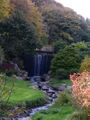
the conservatoire botanique national in autumn
![Saint-Sauveur church in Recouvrance, designed by Amédée-François Frézier, the oldest church of Brest, built in 1750[7]](/w/images/thumb/0/01/Saint-Sauveur-clocher.jpg/90px-Saint-Sauveur-clocher.jpg)
Saint-Sauveur church in Recouvrance, designed by Amédée-François Frézier, the oldest church of Brest, built in 1750[7]
Monumental perspective from the Place de la Liberté opening to the rue de Siam (Siam Street), with the rade de Brest (Brest roadstead) in the background, and on the right, the steeple of Saint-Louis church dominating the rebuilt centre of Brest


![Saint-Sauveur church in Recouvrance, designed by Amédée-François Frézier, the oldest church of Brest, built in 1750[7]](/w/index.php?title=%D9%85%D9%84%D9%81:Saint-Sauveur-clocher.jpg&filetimestamp=20221203052912&)

الجغرافيا


Brest is located amidst a dramatic landscape near the entrance of the natural rade de Brest (Brest roadstead), at the west end of Brittany.
It is situated to the north of a magnificent landlocked bay, and occupies the slopes of two hills divided by the river Penfeld. The part of the town on the left bank is regarded as Brest proper, while the part on the right is known as Recouvrance. There are also extensive suburbs to the east of the town. The hillsides are in some places so steep that the ascent from the lower to the upper town has to be effected by flights of steps and the second or third storey of one house is often on a level with the ground storey of the next.
المناخ
Brest experiences an oceanic climate (Köppen: Cfb) in its classic version (due to its location in the Atlantic Ocean and the sea intrusion[8]) where it shares a considerable moderation shared with other places of the Finistère and islands of Great Britain. As a result of the maritime moderation, Brest has very chilly summers by French standards and in spite of the low latitude, July afternoons are cooler than the norm in far northern Europe. Rainfall is common year-round, but snowfall is a rarer occurrence since temperatures usually remain several degrees above freezing during winter nights.
An extreme temperature of 39.3 °C (102.7 °F) was recorded on 18 July 2022.
| برست، فرنسا | ||||||||||||||||||||||||||||||||||||||||||||||||||||||||||||
|---|---|---|---|---|---|---|---|---|---|---|---|---|---|---|---|---|---|---|---|---|---|---|---|---|---|---|---|---|---|---|---|---|---|---|---|---|---|---|---|---|---|---|---|---|---|---|---|---|---|---|---|---|---|---|---|---|---|---|---|---|
| جدول طقس (التفسير) | ||||||||||||||||||||||||||||||||||||||||||||||||||||||||||||
| ||||||||||||||||||||||||||||||||||||||||||||||||||||||||||||
| ||||||||||||||||||||||||||||||||||||||||||||||||||||||||||||
| بيانات المناخ لـ Brest (Bretagne Airport, altitude 94m, 1991–2020 normals, extremes 1855–present) | |||||||||||||
|---|---|---|---|---|---|---|---|---|---|---|---|---|---|
| الشهر | ينا | فب | مار | أبر | ماي | يون | يول | أغس | سبت | أكت | نوف | ديس | السنة |
| القصوى القياسية °س (°ف) | 16.8 (62.2) |
20.7 (69.3) |
25.0 (77.0) |
28.2 (82.8) |
30.6 (87.1) |
34.3 (93.7) |
39.3 (102.7) |
35.1 (95.2) |
35.0 (95.0) |
28.2 (82.8) |
22.4 (72.3) |
19.0 (66.2) |
39.3 (102.7) |
| متوسط القصوى اليومية °س (°ف) | 9.7 (49.5) |
10.0 (50.0) |
11.9 (53.4) |
13.9 (57.0) |
16.8 (62.2) |
19.1 (66.4) |
20.8 (69.4) |
20.9 (69.6) |
19.3 (66.7) |
16.0 (60.8) |
12.5 (54.5) |
10.3 (50.5) |
15.1 (59.2) |
| المتوسط اليومي °س (°ف) | 7.1 (44.8) |
7.1 (44.8) |
8.6 (47.5) |
10.1 (50.2) |
12.8 (55.0) |
15.3 (59.5) |
17.0 (62.6) |
17.1 (62.8) |
15.4 (59.7) |
12.8 (55.0) |
9.8 (49.6) |
7.7 (45.9) |
11.7 (53.1) |
| متوسط الدنيا اليومية °س (°ف) | 4.6 (40.3) |
4.3 (39.7) |
5.4 (41.7) |
6.3 (43.3) |
8.9 (48.0) |
11.4 (52.5) |
13.1 (55.6) |
13.2 (55.8) |
11.5 (52.7) |
9.6 (49.3) |
7.0 (44.6) |
5.0 (41.0) |
8.4 (47.1) |
| الصغرى القياسية °س (°ف) | −14.0 (6.8) |
−13.4 (7.9) |
−4.9 (23.2) |
−3.0 (26.6) |
−0.8 (30.6) |
3.7 (38.7) |
6.0 (42.8) |
5.8 (42.4) |
3.3 (37.9) |
−1.5 (29.3) |
−6.6 (20.1) |
−10.1 (13.8) |
−14.0 (6.8) |
| متوسط تساقط الأمطار mm (inches) | 142.6 (5.61) |
118.7 (4.67) |
82.2 (3.24) |
91.8 (3.61) |
74.6 (2.94) |
64.6 (2.54) |
70.7 (2.78) |
75.3 (2.96) |
78.6 (3.09) |
129.4 (5.09) |
146.7 (5.78) |
154.6 (6.09) |
1٬229٫8 (48.42) |
| Average precipitation days (≥ 1 mm) | 18.0 | 14.9 | 13.2 | 12.5 | 10.3 | 9.1 | 10.6 | 9.8 | 10.1 | 15.4 | 17.9 | 17.8 | 159.5 |
| متوسط الرطوبة النسبية (%) | 86 | 84 | 82 | 81 | 81 | 83 | 83 | 83 | 85 | 86 | 85 | 86 | 84 |
| Mean monthly ساعات سطوع الشمس | 61.2 | 81.7 | 122.2 | 165.4 | 187.5 | 183.9 | 180.1 | 171.8 | 158.4 | 109.0 | 72.3 | 61.2 | 1٬554٫6 |
| نسبة السطوع المحتمل للشمس | 24.0 | 31.0 | 35.0 | 43.0 | 46.0 | 46.0 | 48.0 | 47.0 | 45.0 | 37.0 | 29.0 | 25.0 | 38.0 |
| Source 1: Meteo France[9][10][11] | |||||||||||||
| Source 2: NOAA (percent sun 1961-1990),[12] Infoclimat.fr (humidity 1961-1990)[13] | |||||||||||||
التعداد
In 1945 Brest absorbed three neighbouring communes.[14] The population data for 1936 and earlier in the table and graph below refer to the pre-1945 borders.
|
| |||||||||||||||||||||||||||||||||||||||||||||||||||||||||||||||||||||||||||||||||||||||||||||||||||||||||||||||||||||
| Source: EHESS[14] and INSEE (1968-2017)[15] | ||||||||||||||||||||||||||||||||||||||||||||||||||||||||||||||||||||||||||||||||||||||||||||||||||||||||||||||||||||||
الاقتصاد

Due to its location, Brest is regarded as the first French port that can be accessed from the Americas. Shipping is big business, although Nantes and Saint-Nazaire offer much larger docks and attract more of the larger vessels. Brest has the ninth French commercial harbour including ship repairs and maintenance. The protected location of Brest means that its harbour is ideal to receive any type of ship, from the smallest dinghy to the biggest aircraft carrier (يوإسإس Nimitz has visited a few times). Naval construction is also an important activity: for example, the French aircraft carrier Charles de Gaulle was built by Direction des Constructions Navales (DCN) in Brest.
Despite its image of an industrialised city whose activity depends mainly on military order, the service sector represents 75% of the economic activity. The importance of the service sector is still increasing while industrialised activity is decaying, explaining the unchanged rate of working-class in Brest. Brest also hosts headquarters for many subsidiaries like the banking group Arkéa. Research and conception is taking an increasing importance. Brest claims to be the largest European centre for sciences and techniques linked to the sea: 60% of the French research in the maritime field is based in Brest.[16]
لغة البريتون
Breton is not commonly spoken in the city of Brest, which was the only French-speaking city in western Brittany before the 1789 French Revolution, despite the surrounding countryside being fully Breton-speaking at that time. Like other French minority languages, Breton does not have any official language status in France.
The municipality launched a linguistic plan to revive Breton as a language through Ya d'ar brezhoneg on 16 June 2006. In 2008, 1.94% of primary-school children attended French-Breton bilingual Diwan schools.[17] Besides bilingual schools, the Breton language is also taught in some schools and universities.
The association Sked federates all Breton cultural activities.[18]
الثقافة

The city is host to several events to celebrate its long maritime history. The largest of these is held every four years, when the town organises a tall ship meeting. The last such tall ship event was "Les Tonnerres de Brest 2016". Due to the COVID-19 pandemic the next event is planned for 2022.
Brest also hosts an annual short film festival called "Brest European Short Film Festival". The city was the setting for the 1982 art film Querelle, directed by Rainer Werner Fassbinder, itself based on the 1947 novel Querelle de Brest by Jean Genet.
الأبحاث والتعليم

Primarily the research centre of western Brittany, Brest and its surrounding area is the home of several research and elite educational establishments:
- a multidisciplinary university, Université de Bretagne Occidentale (UBO) [1]
- Brest has also several grandes écoles and other undergraduate or graduate schools:
- École nationale d'ingénieurs de Brest (ENIB) (in Plouzané next to Brest) [2]
- Télécom Bretagne (ENST Bretagne) (in Plouzané next to Brest) [3]
- École nationale supérieure de techniques avancées de Bretagne (ENSTA Bretagne, formerly ENSIETA) [4]
- Institut supérieur de l'électronique et du numérique de Brest (ISEN Brest) [5]
- Brest Business School (ESC Bretagne Brest) [6]
- École Navale (French Naval Academy) (in Lanvéoc next to Brest) [7]
- To be noted that Brest is one of the hosts for the Indiana University Honors Foreign Language Program
- Brest has several research organisations:
- the largest Ifremer (French Research Institute for Exploitation of the Sea) centre (in Plouzané next to Brest); about 1000 people work there.[19]
- Le Cedre (Centre of Documentation, Research and Experimentation on Accidental Water Pollution)[20]
- the French Polar Institute (in Plouzané next to Brest)
- The Naval Hydrographic and Oceanographic Service (SHOM)
المدن الشقيقة
برست على علاقة شقاقة مع المدن التالي:[21]
 Denver, Colorado, United States (1948)[22]
 Plymouth, Devon, England (1963)[23][24][25]
 Kiel, Germany (1964)
 Taranto, Italy (1964)
 Yokosuka, Kanagawa, Kantō, Japan (1970)
 Dún Laoghaire, Republic of Ireland (1984)
 Cádiz, Spain (1986)
 Saponé, Burkina Faso (1989)
 Constanța, Romania (1993)
 Qingdao, China (2006)
 Brest, Belarus (2012)
علاقات الصداقة
Brest has an official friendly relationship (protocole d'amitié) with:[21]

انظر أيضاً
ملاحظات
المصادر
- ^ "Répertoire national des élus: les maires". data.gouv.fr, Plateforme ouverte des données publiques françaises (in الفرنسية). 2 December 2020.
- ^ Wells, John C. (2008), Longman Pronunciation Dictionary (3rd ed.), Longman, ISBN 9781405881180
- ^ Nouvel atlas linguistique de la Basse-Bretagne, 2001, Volume 1, map 6.
- ^ Koch, John T., ed. (2006). Celtic Culture: A Historical Encyclopedia. Vol. 1. Santa Barbara, California: ABC-CLIO. p. 247. ISBN 1-85109-440-7.
- ^ "Brest". Online Etymology Dictionary. Archived from the original on 21 October 2017. Retrieved 9 July 2021.
- ^ Les Armoiries de Brest[dead link].
- ^ Jean-Louis Auffret, Brest d'hier à demain, Éditions Cloître, March 2002, Saint-Thonan France, ISBN 2-910981-65-7, page 25
- ^ "Brest Map: Detailed maps for the city of Brest – ViaMichelin". viamichelin.co.uk (in الإنجليزية). Retrieved 18 January 2019.
- ^ "Données climatiques de la station de Brest" (in الفرنسية). Meteo France. Archived from the original on 2 August 2019. Retrieved 11 December 2014.
- ^ "Climat Bretagne" (in الفرنسية). Meteo France. Archived from the original on 2 August 2019. Retrieved 11 December 2014.
- ^ "Brest–Guipavas (29)" (PDF). Fiche Climatologique: Statistiques 1981–2010 et records (in الفرنسية). Meteo France. Archived from the original (PDF) on 10 March 2018. Retrieved 10 March 2018.
- ^ "Brest (07110) – WMO Weather Station". NOAA. Retrieved 18 January 2019. Archived 18 January 2019, at the Wayback Machine
- ^ "Normes et records 1961–1990: Brest-Guipavas (29) – altitude 94m" (in الفرنسية). Infoclimat.fr. Archived from the original on 8 أكتوبر 2014. Retrieved 11 ديسمبر 2014.
{{cite web}}: CS1 maint: bot: original URL status unknown (link) 8 October 2014, at the Wayback Machine - ^ أ ب قالب:Cassini-Ehess
- ^ Population en historique depuis 1968, INSEE
- ^ Source: Invest in Brest, BMO Archived 22 نوفمبر 2008 at the Wayback Machine
- ^ (in فرنسية) Ofis ar Brezhoneg: Enseignement bilingue
- ^ "[SKED] Les nouveautés". Sked.infini.fr. Archived from the original on 28 January 2013. Retrieved 26 March 2013.
- ^ "Institut". Ifremer.fr. Retrieved 6 April 2011.
- ^ "Cedre: Centre of Documentation, Research and Experimentation on Accidental Water Pollution". Cedre.fr. 17 March 2011. Retrieved 6 April 2011.
- ^ أ ب Les jumelages de Brest
- ^ "Our First Sister City" (PDF). Denver Sister Cities International. Archived from the original (PDF) on 21 November 2015. Retrieved 20 November 2015.
- ^ "British towns twinned with French towns". Archant Community Media Ltd. Archived from the original on 5 July 2013. Retrieved 11 July 2013.
- ^ "Les jumelages". Brest.fr. Archived from the original on 25 May 2011. Retrieved 6 April 2011.
- ^ "Twin towns". Plymouth City Council. Retrieved 1 March 2008.
وصلات خارجية
- Aerial photos of the whole city and urban community
- Brest Airport Travel Guide
- Interactive City Map of Brest
- Official web site of Brest town hall (with webcam)
- Satellite picture by Google Maps
- (بالفرنسية) Cultural Heritage
- Brest improvisation theatre
- Brest Weather Forecast
- "Brest, ma ville, mon âme" Photo gallery : a discovery of the city by Erwan Corre
- Wiki-Brest, a community wiki containing articles about the city (in French).
- Pages using gadget WikiMiniAtlas
- صفحات بها مخططات
- CS1 الفرنسية-language sources (fr)
- Articles with dead external links from November 2016
- CS1 maint: bot: original URL status unknown
- Articles with فرنسية-language sources (fr)
- Short description is different from Wikidata
- Coordinates on Wikidata
- صفحات تستخدم جدول مستوطنة بقائمة محتملة لصفات المواطن
- Pages using infobox settlement with image map1 but not image map
- Pages with plain IPA
- Articles with hatnote templates targeting a nonexistent page
- برست
- مدن فرنسا
- مدن ساحلية في فرنسا
- مدن موانئ وبلدات في فرنسا
- Communes of Finistère
- مراكز الدوائر الادارية في فرنسا