صخر رسوبي
| جزء من سلسلة عن |
| الرواسب |
|---|
 |

الصخور الرسوبية (إنگليزية: Sedimentary rocks)، هي نوع من أنواع الصخور التي تتشكل بتراكم أو ترسب الجسيمات المعدنية أو العضوية على سطح الأرض، ثم تتماسك. الترسيب هو الاسم الجماعي للعمليات التي تتسبب في استقرار هذه الجسيمات في مكانها. تسمى الجسيمات التي تشكل الصخور الرسوبية بالرواسب، وقد تتكون من الحتات الجيولوجي (المعادن) أو الحتات الحيوي (مادة عضوية). ينشأ الحتات الجيولوجي من تجوية وتعرية الصخور الموجودة، أو من تجمد كتل الحمم المنصهرة التي اندلعت بواسطة البراكين. ينتقل الحتات الجيولوجي إلى مكان الترسيب عن طريق المياه، الرياح، الجليد أو حركة الكتلة، التي تسمى عوامل التعرية. يتشكل الحتات الحيوي عن طريق أجسام وأجزاء (الأصداف بشكل رئيسي) العضيات المائية الميتة، وكذلك كتلتها البرازية، المعلقة في المياه والتي تترسب ببطيء على قاع الأجسام المائية (الثلج البحري). قد يحدث الترسيب أيضًا عندما تترسب المعادن الذائبة من المحلول المائي.
الغطاء الصخري الرسوبي لقشرة الأرض شاسع (73% من سطح الأرض الحالي)،[1] لكن الصخور الرسوبية تقدر بـ 8% فقط من حجم القشرة.[2] الصخور الرسوبية ليست سوى طبقة رقيقة فوق قشرة تتكون أساسًا من الصخور النارية والمتحولة. تترسب الصخور الرسوبية في طبقات، وتشكل بنية تسمى الأديم. غالبًا ما تترسب الصخور الرسوبية في هياكل كبيرة تسمى الأحواض الرسوبية. كما عُثر على صخور رسوبية على كوكب المريخ.
توفر دراسة الصخور الرسوبية وطبقات الصخور معلومات حول باطن الأرض والتي تفيد في مجال الهندسة المدنية، على سبيل المثال في إنشاء الطرق، المنازل، الأنفاق، القنوات أو المنشآت الأخرى. الصخور الرسوبية هي أيضًا مصادر هامة للموارد الطبيعية بما في ذلك الفحم والوقود الأحفوري ومياه الشرب والمواد الخام.
تعد دراسة تسلسل طبقات الصخور الرسوبية المصدر الرئيسي لفهم تاريخ الأرض، بما في ذلك الجغرافيا القديمة وعلم المناخ القديم وتاريخ الحياة.
يُطلق على التخصص العلمي الذي يدرس خصائص وأصل الصخور الرسوبية علم الرسوبيات. علم الرسوبيات هو جزء من الجيولوجيا والجغرافيا الطبيعية ويتداخل جزئيًا مع التخصصات الأخرى في علوم الأرض، مثل علم أحوال التربة، علم تشكل الأرض والجيوكيمياء والجيولوجيا الإنشائية.
التصنيف تبعاً للأصل
,_Sunset.jpg&filetimestamp=20221225185055&)
يمكن تقسيم الصخور الرسوبية إلى أربع مجموعات بناءً على العمليات المسؤولة عن تكوينها: الصخور الرسوبية الصخرية، والصخور الرسوبية البيوكيميائية (الحيوية)، والصخور الرسوبية الكيميائية، وفئة رابعة للصخور الرسوبية "الأخرى" المتكونة من التأثيرات، النشاط البركاني، وعمليات ثانوية أخرى.
الصخور الرسوبية الفتاتية

تتكون الصخور الرسوبية الفتاتية من شظايا صخرية ثُقبتت معًا. وعادة ما تكون الكتل عبارة عن حبيبات فردية من الكوارتز، الفلسبار، المعادن الطينية، أو الميكا. ومع ذلك، قد يوجد أي نوع من المعادن. قد تكون الكتل أيضًا "شظايا حجرية" تتكون من أكثر من معدن واحد
تنقسم الصخور الرسوبية الفتاتية وفقًا لحجم الجسيمات السائدة. يستخدم معظم الجيولوجيين مقياس أودن-وينتورث لحجم الحبيبات ويقسمون الرواسب غير المجمعة إلى ثلاثة أجزاء: الحصى (بقطر >2 مم)، الرمل (بقطر 1/16 إلى 2 مم)، والطين (بقطر <1/16 مم). ينقسم الطين بدوره إلى الغرين (بقطر 1/16 إلى 1/256 مم) والصلصال (بقطر <1/256 مم). يوازي تصنيف الصخور الرسوبية الفتاتية هذا المخطط؛ تتكون الرصيص والبرتشيا في الغالب من الحصى، وتتكون الأحجار الرملية في الغالب من الرمل، وتكون الصخور الطينية في معظمها من الطين. ينعكس هذا التقسيم الفرعي الثلاثي في الأدبيات القديمة، في الفئات الواسعة من الريديت والأرينيت واللوتيت على التوالي.
الرصيص والبرتشيا
يتكون الرصيص بشكل أساسي من الحصى المستدير، بينما تتكون البرتشيا من الحصى ذي الزوايا السائدة.
الأحجار الرملية


تختلف مخططات تصنيف الحجر الرملي على نطاق واسع، لكن معظم الجيولوجيين اعتمدوا مخطط دوت،[3] التي تستخدم الوفرة النسبية لحبيبات الكوارتز والفلسبار والحجر الصخري ووفرة مصفوفة طينية بين الحبيبات الكبيرة.
- تكوين الحبيبات الهيكلية
- الوفرة النسبية للحبيبات الهيكلية بحجم الرمل تحدد الكلمة الأولى في اسم الحجر الرملي. تعتمد التسمية على هيمنة المكونات الثلاثة الأكثر وفرة: الكوارتز، الفلسبار، أو الأجزاء الحجرية التي نشأت من الصخور الأخرى. تعتبر جميع المعادن الأخرى من الملحقات ولا تستخدم في تسمية الصخور بغض النظر عن وفرتها.
- أحجار الكوارتز الرملية بها أكثر من 90% حبيبات الكوارتز
- * تحتوي الأحجار الرملية الفلسبارية على نسبة أقل من 90% من حبيبات الكوارتز وحبيبات الفلسبار أكثر من حبيبات الحجر الصخري
- * تحتوي الأحجار الرملية الحجرية على نسبة تقل عن 90% من حبيبات الكوارتز وحبيبات حجرية أكثر من حبيبات الفلسبار
- وفرة مادة المصفوفة الطينية بين حبيبات الرمل
- عندما تترسب جزيئات بحجم الرمل، يظل الفراغ بين الحبيبات مفتوحًا أو مملوءًا بالطين (الطمي و/أو جسيمات بحجم الطين).
- * الأحجار الرملية "النظيفة" ذات المسام المفتوحة (التي قد تملأ فيما بعد بمواد مصفوفة) تسمى أرينيت.
- * الأحجار الرملية الموحلة ذات المصفوفة الطينية الوفيرة (>10%) تسمى wackes.
هناك ستة أسماء من الحجر الرملي ممكنة باستخدام واصفات تكوين الحبيبات (quartz-, feldspathic-, and lithic-) وكمية المصفوفة (wacke أو arenite). على سبيل المثال، سيتكون أرنيت الكوارتز في الغالب (>90%) من حبيبات كوارتز ولديه مصفوفة طينية قليلة أو معدومة بين الحبيبات، وستحتوي الصخرة الحجرية على حبيبات حجرية وفيرة ومصفوفة موحلة وفيرة، إلخ.
على الرغم من أن مخطط تصنيف دوت [3] يستخدم على نطاق واسع من قبل علماء الرسوبيات، ولا تزال الأسماء الشائعة مثل greywacke وarkose وحجر الكوارتز الرملي مستخدمة على نطاق واسع من قبل غير المتخصصين وفي الأدب الشعبي.
الصخور الطينية
الصخور الطينية هي صخور رسوبية تتكون من 50% على الأقل من جزيئات الغرين والطين. عادة ما تنتقل هذه الجسيمات الدقيقة نسبيًا عن طريق الجريان المضطرب في الماء أو الهواء، وتترسب عندما يهدأ الجريان وتستقر الجسيمات من المعلق.
يستخدم معظم المؤلفين حاليًا مصطلح "الصخر الطيني" للإشارة إلى جميع الصخور المكونة بشكل أساسي من الطين.[4][5][6][7] يمكن تقسيم الأحجار الطينية إلى أحجار غرينية، تتكون في الغالب من جزيئات بحجم الغرين؛ أحجار طينية ذات خليط شبه متكافئ من جزيئات بحجم الغرين والطمي؛ والأحجار الصلصالية، وتتكون في الغالب من جزيئات بحجم الصلصال.[4][5] يستخدم معظم المؤلفين "الطفل الصفحي" كمصطلح لانشطارية الطين (بغض النظر عن حجم الحبيبات) على الرغم من أن بعض الأدبيات القديمة تستخدم مصطلح "الطفل الصخري" كمرادف للصخر الطيني.
الصخور الرسوبية الكيميائية-الحيوية

تتشكل الصخور الرسوبية الكيميائية الحيوية عندما تستخدم العضيات مواد مذابة في الهواء أو الماء لبناء أنسجتها. تتضمن الأمثلة على ذلك:
- تتكون معظم أنواع الحجر الجيري من الهياكل العظمية الجيرية لكائنات مثل المرجان والرخويات والمنخربات.
- الفحم، يتكون من نباتات أزالت الكربون من الغلاف الجوي ودمجته مع عناصر أخرى لبناء أنسجتها.
- تكونت رواسب الشرت من تراكم الهياكل العظمية الصليبية للعضيات الدقيقة مثل الراديولاريات والدياتومات.
الصخور الرسوبية الكيميائية
تتشكل الصخور الرسوبية الكيميائية عندما تصبح المكونات المعدنية في محلول مفرط التشبع وراسب غير عضوي. تشمل الصخور الرسوبية الكيميائية الشائعة حجر الأوليت الجيري والصخور المكونة من متبخرات المعادن، مثل الهاليت (ملح الصخور)، السيلڤيت، الباريت والجبس.
صخور رسوبية أخرى
تتضمن هذه الفئة الرابعة المتنوعة الطف والبرتشيا البركانية التي تشكلت عن طريق الترسب والتثبيت اللاحق لشظايا الحمم البركانية التي اندلعت بواسطة البراكين، وتأثير البرتشيا تشكلت بعد الاصطدام.
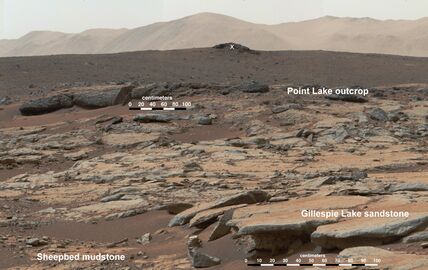
صخور رسوبية على المريخ يتفحصها جوال المريخ كيريوسيتي التابع لناسا.

طبقات صخور رسوبية على امتداد طريق چالوس في شمال إيران.

بقايا طبقية لمخروط پوئو ماهانا.


التصنيف تبعاً للتكوين

Alternatively, sedimentary rocks can be subdivided into compositional groups based on their mineralogy:
- Siliciclastic sedimentary rocks, are dominantly composed of silicate minerals. The sediment that makes up these rocks was transported as bed load, suspended load, or by sediment gravity flows. Siliciclastic sedimentary rocks are subdivided into conglomerates and breccias, sandstone, and mudrocks.
- Carbonate sedimentary rocks are composed of calcite (rhombohedral CaCO 3), aragonite (orthorhombic CaCO 3), dolomite (CaMg(CO 3) 2), and other carbonate minerals based on the CO2−3 ion. Common examples include limestone and the rock dolomite.
- Evaporite sedimentary rocks are composed of minerals formed from the evaporation of water. The most common evaporite minerals are carbonates (calcite and others based on CO2−3), chlorides (halite and others built on Cl− ), and sulfates (gypsum and others built on SO2−4). Evaporite rocks commonly include abundant halite (rock salt), gypsum, and anhydrite.
- Organic-rich sedimentary rocks have significant amounts of organic material, generally in excess of 3% total organic carbon. Common examples include coal, oil shale as well as source rocks for oil and natural gas.
- Siliceous sedimentary rocks are almost entirely composed of silica (SiO 2), typically as chert, opal, chalcedony or other microcrystalline forms.
- Iron-rich sedimentary rocks are composed of >15% iron; the most common forms are banded iron formations and ironstones.[5]
- Phosphatic sedimentary rocks are composed of phosphate minerals and contain more than 6.5% phosphorus; examples include deposits of phosphate nodules, bone beds, and phosphatic mudrocks.[6]
الترسب والتحول
انتقال الرواسب وترسبها

Sedimentary rocks are formed when sediment is deposited out of air, ice, wind, gravity, or water flows carrying the particles in suspension. This sediment is often formed when weathering and erosion break down a rock into loose material in a source area. The material is then transported from the source area to the deposition area. The type of sediment transported depends on the geology of the hinterland (the source area of the sediment). However, some sedimentary rocks, such as evaporites, are composed of material that form at the place of deposition. The nature of a sedimentary rock, therefore, not only depends on the sediment supply, but also on the sedimentary depositional environment in which it formed.
التحول

As sediments accumulate in a depositional environment, older sediments are buried by younger sediments, and they undergo diagenesis. Diagenesis includes all the chemical, physical, and biological changes, exclusive of surface weathering, undergone by a sediment after its initial deposition. This includes compaction and lithification of the sediments.[8] Early stages of diagenesis, described as eogenesis, take place at shallow depths (a few tens of meters) and is characterized by bioturbation and mineralogical changes in the sediments, with only slight compaction.[9] The red hematite that gives red bed sandstones their color is likely formed during eogenesis.[10][8] Some biochemical processes, like the activity of bacteria, can affect minerals in a rock and are therefore seen as part of diagenesis.[11]
Deeper burial is accompanied by mesogenesis, during which most of the compaction and lithification takes place. Compaction takes place as the sediments come under increasing overburden (lithostatic) pressure from overlying sediments. Sediment grains move into more compact arrangements, grains of ductile minerals (such as mica) are deformed, and pore space is reduced. Sediments are typically saturated with groundwater or seawater when originally deposited, and as pore space is reduced, much of these connate fluids are expelled. In addition to this physical compaction, chemical compaction may take place via pressure solution. Points of contact between grains are under the greatest strain, and the strained mineral is more soluble than the rest of the grain. As a result, the contact points are dissolved away, allowing the grains to come into closer contact.[8] The increased pressure and temperature stimulate further chemical reactions, such as the reactions by which organic material becomes lignite or coal.[12]
Lithification follows closely on compaction, as increased temperatures at depth hasten the precipitation of cement that binds the grains together. Pressure solution contributes to this process of cementation, as the mineral dissolved from strained contact points is redeposited in the unstrained pore spaces. This further reduces porosity and makes the rock more compact and competent.[8]
Unroofing of buried sedimentary rock is accompanied by telogenesis, the third and final stage of diagenesis.[9] As erosion reduces the depth of burial, renewed exposure to meteoric water produces additional changes to the sedimentary rock, such as leaching of some of the cement to produce secondary porosity.[8]
At sufficiently high temperature and pressure, the realm of diagenesis makes way for metamorphism, the process that forms metamorphic rock.[13]
الخصائص

اللون
The color of a sedimentary rock is often mostly determined by iron, an element with two major oxides: iron(II) oxide and iron(III) oxide. Iron(II) oxide (FeO) only forms under low oxygen (anoxic) circumstances and gives the rock a grey or greenish colour. Iron(III) oxide (Fe2O3) in a richer oxygen environment is often found in the form of the mineral hematite and gives the rock a reddish to brownish colour. In arid continental climates rocks are in direct contact with the atmosphere, and oxidation is an important process, giving the rock a red or orange colour. Thick sequences of red sedimentary rocks formed in arid climates are called red beds. However, a red colour does not necessarily mean the rock formed in a continental environment or arid climate.[14]
The presence of organic material can colour a rock black or grey. Organic material is formed from dead organisms, mostly plants. Normally, such material eventually decays by oxidation or bacterial activity. Under anoxic circumstances, however, organic material cannot decay and leaves a dark sediment, rich in organic material. This can, for example, occur at the bottom of deep seas and lakes. There is little water mixing in such environments; as a result, oxygen from surface water is not brought down, and the deposited sediment is normally a fine dark clay. Dark rocks, rich in organic material, are therefore often shales.[14][15]
الملمس

The size, form and orientation of clasts (the original pieces of rock) in a sediment is called its texture. The texture is a small-scale property of a rock, but determines many of its large-scale properties, such as the density, porosity or permeability.[16]
The 3D orientation of the clasts is called the fabric of the rock. The size and form of clasts can be used to determine the velocity and direction of current in the sedimentary environment that moved the clasts from their origin; fine, calcareous mud only settles in quiet water while gravel and larger clasts are moved only by rapidly moving water.[17][18] The grain size of a rock is usually expressed with the Wentworth scale, though alternative scales are sometimes used. The grain size can be expressed as a diameter or a volume, and is always an average value, since a rock is composed of clasts with different sizes. The statistical distribution of grain sizes is different for different rock types and is described in a property called the sorting of the rock. When all clasts are more or less of the same size, the rock is called 'well-sorted', and when there is a large spread in grain size, the rock is called 'poorly sorted'.[19][20]

The form of the clasts can reflect the origin of the rock. For example, coquina, a rock composed of clasts of broken shells, can only form in energetic water. The form of a clast can be described by using four parameters:[21][22]
- Surface texture describes the amount of small-scale relief of the surface of a grain that is too small to influence the general shape. For example, frosted grains, which are covered with small-scale fractures, are characteristic of eolian sandstones.[23]
- Rounding describes the general smoothness of the shape of a grain.
- Sphericity describes the degree to which the grain approaches a sphere.
- Grain form describes the three-dimensional shape of the grain.
Chemical sedimentary rocks have a non-clastic texture, consisting entirely of crystals. To describe such a texture, only the average size of the crystals and the fabric are necessary.
علم المعادن

Most sedimentary rocks contain either quartz (siliciclastic rocks) or calcite (carbonate rocks). In contrast to igneous and metamorphic rocks, a sedimentary rock usually contains very few different major minerals. However, the origin of the minerals in a sedimentary rock is often more complex than in an igneous rock. Minerals in a sedimentary rock may have been present in the original sediments or may formed by precipitation during diagenesis. In the second case, a mineral precipitate may have grown over an older generation of cement.[24] A complex diagenetic history can be established by optical mineralogy, using a petrographic microscope.
Carbonate rocks predominantly consist of carbonate minerals such as calcite, aragonite or dolomite. Both the cement and the clasts (including fossils and ooids) of a carbonate sedimentary rock usually consist of carbonate minerals. The mineralogy of a clastic rock is determined by the material supplied by the source area, the manner of its transport to the place of deposition and the stability of that particular mineral.
The resistance of rock-forming minerals to weathering is expressed by the Goldich dissolution series. In this series, quartz is the most stable, followed by feldspar, micas, and finally other less stable minerals that are only present when little weathering has occurred.[25] The amount of weathering depends mainly on the distance to the source area, the local climate and the time it took for the sediment to be transported to the point where it is deposited. In most sedimentary rocks, mica, feldspar and less stable minerals have been weathered to clay minerals like kaolinite, illite or smectite.
الأحفورات

Among the three major types of rock, fossils are most commonly found in sedimentary rock. Unlike most igneous and metamorphic rocks, sedimentary rocks form at temperatures and pressures that do not destroy fossil remnants. Often these fossils may only be visible under magnification.
Dead organisms in nature are usually quickly removed by scavengers, bacteria, rotting and erosion, but under exceptional circumstances, these natural processes are unable to take place, leading to fossilisation. The chance of fossilisation is higher when the sedimentation rate is high (so that a carcass is quickly buried), in anoxic environments (where little bacterial activity occurs) or when the organism had a particularly hard skeleton. Larger, well-preserved fossils are relatively rare.

Fossils can be both the direct remains or imprints of organisms and their skeletons. Most commonly preserved are the harder parts of organisms such as bones, shells, and the woody tissue of plants. Soft tissue has a much smaller chance of being fossilized, and the preservation of soft tissue of animals older than 40 million years is very rare.[26] Imprints of organisms made while they were still alive are called trace fossils, examples of which are burrows, footprints, etc.
As a part of a sedimentary rock, fossils undergo the same diagenetic processes as does the host rock. For example, a shell consisting of calcite can dissolve while a cement of silica then fills the cavity. In the same way, precipitating minerals can fill cavities formerly occupied by blood vessels, vascular tissue or other soft tissues. This preserves the form of the organism but changes the chemical composition, a process called permineralization.[27][28] The most common minerals involved in permineralization are various forms of amorphous silica (chalcedony, flint, chert), carbonates (especially calcite), and pyrite.
At high pressure and temperature, the organic material of a dead organism undergoes chemical reactions in which volatiles such as water and carbon dioxide are expulsed. The fossil, in the end, consists of a thin layer of pure carbon or its mineralized form, graphite. This form of fossilisation is called carbonisation. It is particularly important for plant fossils.[29] The same process is responsible for the formation of fossil fuels like lignite or coal.
الهياكل الرسوبية الأولية


Structures in sedimentary rocks can be divided into primary structures (formed during deposition) and secondary structures (formed after deposition). Unlike textures, structures are always large-scale features that can easily be studied in the field. Sedimentary structures can indicate something about the sedimentary environment or can serve to tell which side originally faced up where tectonics have tilted or overturned sedimentary layers.
Sedimentary rocks are laid down in layers called beds or strata. A bed is defined as a layer of rock that has a uniform lithology and texture. Beds form by the deposition of layers of sediment on top of each other. The sequence of beds that characterizes sedimentary rocks is called bedding.[30][31] Single beds can be a couple of centimetres to several meters thick. Finer, less pronounced layers are called laminae, and the structure a lamina forms in a rock is called lamination. Laminae are usually less than a few centimetres thick.[32] Though bedding and lamination are often originally horizontal in nature, this is not always the case. In some environments, beds are deposited at a (usually small) angle. Sometimes multiple sets of layers with different orientations exist in the same rock, a structure called cross-bedding.[33] Cross-bedding is characteristic of deposition by a flowing medium (wind or water).
The opposite of cross-bedding is parallel lamination, where all sedimentary layering is parallel.[34] Differences in laminations are generally caused by cyclic changes in the sediment supply, caused, for example, by seasonal changes in rainfall, temperature or biochemical activity. Laminae that represent seasonal changes (similar to tree rings) are called varves. Any sedimentary rock composed of millimeter or finer scale layers can be named with the general term laminite. When sedimentary rocks have no lamination at all, their structural character is called massive bedding.
Graded bedding is a structure where beds with a smaller grain size occur on top of beds with larger grains. This structure forms when fast flowing water stops flowing. Larger, heavier clasts in suspension settle first, then smaller clasts. Although graded bedding can form in many different environments, it is a characteristic of turbidity currents.[35]
The surface of a particular bed, called the bedform, can also be indicative of a particular sedimentary environment. Examples of bed forms include dunes and ripple marks. Sole markings, such as tool marks and flute casts, are grooves eroded on a surface that are preserved by renewed sedimentation. These are often elongated structures and can be used to establish the direction of the flow during deposition.[36][37]
Ripple marks also form in flowing water. There can be symmetric or asymmetric. Asymmetric ripples form in environments where the current is in one direction, such as rivers. The longer flank of such ripples is on the upstream side of the current.[38][39][40] Symmetric wave ripples occur in environments where currents reverse directions, such as tidal flats.
Mudcracks are a bed form caused by the dehydration of sediment that occasionally comes above the water surface. Such structures are commonly found at tidal flats or point bars along rivers.
الهياكل الرسوبية الثانوية

Secondary sedimentary structures are those which formed after deposition. Such structures form by chemical, physical and biological processes within the sediment. They can be indicators of circumstances after deposition. Some can be used as way up criteria.
Organic materials in a sediment can leave more traces than just fossils. Preserved tracks and burrows are examples of trace fossils (also called ichnofossils).[41] Such traces are relatively rare. Most trace fossils are burrows of molluscs or arthropods. This burrowing is called bioturbation by sedimentologists. It can be a valuable indicator of the biological and ecological environment that existed after the sediment was deposited. On the other hand, the burrowing activity of organisms can destroy other (primary) structures in the sediment, making a reconstruction more difficult.

Secondary structures can also form by diagenesis or the formation of a soil (pedogenesis) when a sediment is exposed above the water level. An example of a diagenetic structure common in carbonate rocks is a stylolite.[42] Stylolites are irregular planes where material was dissolved into the pore fluids in the rock. This can result in the precipitation of a certain chemical species producing colouring and staining of the rock, or the formation of concretions. Concretions are roughly concentric bodies with a different composition from the host rock. Their formation can be the result of localized precipitation due to small differences in composition or porosity of the host rock, such as around fossils, inside burrows or around plant roots.[43] In carbonate rocks such as limestone or chalk, chert or flint concretions are common, while terrestrial sandstones sometimes contain iron concretions. Calcite concretions in clay containing angular cavities or cracks are called septarian concretions.
After deposition, physical processes can deform the sediment, producing a third class of secondary structures. Density contrasts between different sedimentary layers, such as between sand and clay, can result in flame structures or load casts, formed by inverted diapirism.[44] While the clastic bed is still fluid, diapirism can cause a denser upper layer to sink into a lower layer. Sometimes, density contrasts occur or are enhanced when one of the lithologies dehydrates. Clay can be easily compressed as a result of dehydration, while sand retains the same volume and becomes relatively less dense. On the other hand, when the pore fluid pressure in a sand layer surpasses a critical point, the sand can break through overlying clay layers and flow through, forming discordant bodies of sedimentary rock called sedimentary dykes. The same process can form mud volcanoes on the surface where they broke through upper layers.
Sedimentary dykes can also be formed in a cold climate where the soil is permanently frozen during a large part of the year. Frost weathering can form cracks in the soil that fill with rubble from above. Such structures can be used as climate indicators as well as way up structures.[45]
Density contrasts can also cause small-scale faulting, even while sedimentation progresses (synchronous-sedimentary faulting).[46] Such faulting can also occur when large masses of non-lithified sediment are deposited on a slope, such as at the front side of a delta or the continental slope. Instabilities in such sediments can result in the deposited material to slump, producing fissures and folding. The resulting structures in the rock are syn-sedimentary folds and faults, which can be difficult to distinguish from folds and faults formed by tectonic forces acting on lithified rocks.
البيئات الرسوبية


The setting in which a sedimentary rock forms is called the depositional environment. Every environment has a characteristic combination of geologic processes, and circumstances. The type of sediment that is deposited is not only dependent on the sediment that is transported to a place (provenance), but also on the environment itself.[47]
A marine environment means that the rock was formed in a sea or ocean. Often, a distinction is made between deep and shallow marine environments. Deep marine usually refers to environments more than 200 m below the water surface (including the abyssal plain). Shallow marine environments exist adjacent to coastlines and can extend to the boundaries of the continental shelf. The water movements in such environments have a generally higher energy than that in deep environments, as wave activity diminishes with depth. This means that coarser sediment particles can be transported and the deposited sediment can be coarser than in deeper environments. When the sediment is transported from the continent, an alternation of sand, clay and silt is deposited. When the continent is far away, the amount of such sediment deposited may be small, and biochemical processes dominate the type of rock that forms. Especially in warm climates, shallow marine environments far offshore mainly see deposition of carbonate rocks. The shallow, warm water is an ideal habitat for many small organisms that build carbonate skeletons. When these organisms die, their skeletons sink to the bottom, forming a thick layer of calcareous mud that may lithify into limestone. Warm shallow marine environments also are ideal environments for coral reefs, where the sediment consists mainly of the calcareous skeletons of larger organisms.[48]
In deep marine environments, the water current working the sea bottom is small. Only fine particles can be transported to such places. Typically sediments depositing on the ocean floor are fine clay or small skeletons of micro-organisms. At 4 km depth, the solubility of carbonates increases dramatically (the depth zone where this happens is called the lysocline). Calcareous sediment that sinks below the lysocline dissolves; as a result, no limestone can be formed below this depth. Skeletons of micro-organisms formed of silica (such as radiolarians) are not as soluble and are still deposited. An example of a rock formed of silica skeletons is radiolarite. When the bottom of the sea has a small inclination, for example, at the continental slopes, the sedimentary cover can become unstable, causing turbidity currents. Turbidity currents are sudden disturbances of the normally quiet deep marine environment and can cause the near-instantaneous deposition of large amounts of sediment, such as sand and silt. The rock sequence formed by a turbidity current is called a turbidite.[49]
The coast is an environment dominated by wave action. At a beach, dominantly denser sediment such as sand or gravel, often mingled with shell fragments, is deposited, while the silt and clay sized material is kept in mechanical suspension. Tidal flats and shoals are places that sometimes dry because of the tide. They are often cross-cut by gullies, where the current is strong and the grain size of the deposited sediment is larger. Where rivers enter the body of water, either on a sea or lake coast, deltas can form. These are large accumulations of sediment transported from the continent to places in front of the mouth of the river. Deltas are dominantly composed of clastic (rather than chemical) sediment.
A continental sedimentary environment is an environment in the interior of a continent. Examples of continental environments are lagoons, lakes, swamps, floodplains and alluvial fans. In the quiet water of swamps, lakes and lagoons, fine sediment is deposited, mingled with organic material from dead plants and animals. In rivers, the energy of the water is much greater and can transport heavier clastic material. Besides transport by water, sediment can be transported by wind or glaciers. Sediment transported by wind is called aeolian and is almost always very well sorted, while sediment transported by a glacier is called glacial till and is characterized by very poor sorting.[50]
Aeolian deposits can be quite striking. The depositional environment of the Touchet Formation, located in the Northwestern United States, had intervening periods of aridity which resulted in a series of rhythmite layers. Erosional cracks were later infilled with layers of soil material, especially from aeolian processes. The infilled sections formed vertical inclusions in the horizontally deposited layers, and thus provided evidence of the sequence of events during deposition of the forty-one layers of the formation.[51]
الأوجه الرسوبية
The kind of rock formed in a particular depositional environment is called its sedimentary facies. Sedimentary environments usually exist alongside each other in certain natural successions. A beach, where sand and gravel is deposited, is usually bounded by a deeper marine environment a little offshore, where finer sediments are deposited at the same time. Behind the beach, there can be dunes (where the dominant deposition is well sorted sand) or a lagoon (where fine clay and organic material is deposited). Every sedimentary environment has its own characteristic deposits. When sedimentary strata accumulate through time, the environment can shift, forming a change in facies in the subsurface at one location. On the other hand, when a rock layer with a certain age is followed laterally, the lithology (the type of rock) and facies eventually change.[52]

Facies can be distinguished in a number of ways: the most common are by the lithology (for example: limestone, siltstone or sandstone) or by fossil content. Coral, for example, only lives in warm and shallow marine environments and fossils of coral are thus typical for shallow marine facies. Facies determined by lithology are called lithofacies; facies determined by fossils are biofacies.[53]
Sedimentary environments can shift their geographical positions through time. Coastlines can shift in the direction of the sea when the sea level drops (regression), when the surface rises (transgression) due to tectonic forces in the Earth's crust or when a river forms a large delta. In the subsurface, such geographic shifts of sedimentary environments of the past are recorded in shifts in sedimentary facies. This means that sedimentary facies can change either parallel or perpendicular to an imaginary layer of rock with a fixed age, a phenomenon described by Walther's Law.[54]
The situation in which coastlines move in the direction of the continent is called transgression. In the case of transgression, deeper marine facies are deposited over shallower facies, a succession called onlap. Regression is the situation in which a coastline moves in the direction of the sea. With regression, shallower facies are deposited on top of deeper facies, a situation called offlap.[55]
The facies of all rocks of a certain age can be plotted on a map to give an overview of the palaeogeography. A sequence of maps for different ages can give an insight in the development of the regional geography.
معرض صور الأوجه الرسوبية
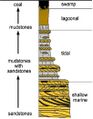
A regressive facies shown on a stratigraphic column

الأحواض الرسوبية

Places where large-scale sedimentation takes place are called sedimentary basins. The amount of sediment that can be deposited in a basin depends on the depth of the basin, the so-called accommodation space. The depth, shape and size of a basin depend on tectonics, movements within the Earth's lithosphere. Where the lithosphere moves upward (tectonic uplift), land eventually rises above sea level and the area becomes a source for new sediment as erosion removes material. Where the lithosphere moves downward (tectonic subsidence), a basin forms and sediments are deposited.
A type of basin formed by the moving apart of two pieces of a continent is called a rift basin. Rift basins are elongated, narrow and deep basins. Due to divergent movement, the lithosphere is stretched and thinned, so that the hot asthenosphere rises and heats the overlying rift basin. Apart from continental sediments, rift basins normally also have part of their infill consisting of volcanic deposits. When the basin grows due to continued stretching of the lithosphere, the rift grows and the sea can enter, forming marine deposits.
When a piece of lithosphere that was heated and stretched cools again, its density rises, causing isostatic subsidence. If this subsidence continues long enough, the basin is called a sag basin. Examples of sag basins are the regions along passive continental margins, but sag basins can also be found in the interior of continents. In sag basins, the extra weight of the newly deposited sediments is enough to keep the subsidence going in a vicious circle. The total thickness of the sedimentary infill in a sag basin can thus exceed 10 km.
A third type of basin exists along convergent plate boundaries – places where one tectonic plate moves under another into the asthenosphere. The subducting plate bends and forms a fore-arc basin in front of the overriding plate – an elongated, deep asymmetric basin. Fore-arc basins are filled with deep marine deposits and thick sequences of turbidites. Such infill is called flysch. When the convergent movement of the two plates results in continental collision, the basin becomes shallower and develops into a foreland basin. At the same time, tectonic uplift forms a mountain belt in the overriding plate, from which large amounts of material are eroded and transported to the basin. Such erosional material of a growing mountain chain is called molasse and has either a shallow marine or a continental facies.
At the same time, the growing weight of the mountain belt can cause isostatic subsidence in the area of the overriding plate on the other side to the mountain belt. The basin type resulting from this subsidence is called a back-arc basin and is usually filled by shallow marine deposits and molasse.[56]

تأثير الدورات الفلكية
In many cases facies changes and other lithological features in sequences of sedimentary rock have a cyclic nature. This cyclic nature was caused by cyclic changes in sediment supply and the sedimentary environment. Most of these cyclic changes are caused by astronomic cycles. Short astronomic cycles can be the difference between the tides or the spring tide every two weeks. On a larger time-scale, cyclic changes in climate and sea level are caused by Milankovitch cycles: cyclic changes in the orientation and/or position of the Earth's rotational axis and orbit around the Sun. There are a number of Milankovitch cycles known, lasting between 10,000 and 200,000 years.[57]
Relatively small changes in the orientation of the Earth's axis or length of the seasons can be a major influence on the Earth's climate. An example are the ice ages of the past 2.6 million years (the Quaternary period), which are assumed to have been caused by astronomic cycles.[58][59] Climate change can influence the global sea level (and thus the amount of accommodation space in sedimentary basins) and sediment supply from a certain region. Eventually, small changes in astronomic parameters can cause large changes in sedimentary environment and sedimentation.
معدلات الترسيب
The rate at which sediment is deposited differs depending on the location. A channel in a tidal flat can see the deposition of a few metres of sediment in one day, while on the deep ocean floor each year only a few millimetres of sediment accumulate. A distinction can be made between normal sedimentation and sedimentation caused by catastrophic processes. The latter category includes all kinds of sudden exceptional processes like mass movements, rock slides or flooding. Catastrophic processes can see the sudden deposition of a large amount of sediment at once. In some sedimentary environments, most of the total column of sedimentary rock was formed by catastrophic processes, even though the environment is usually a quiet place. Other sedimentary environments are dominated by normal, ongoing sedimentation.[60]
In many cases, sedimentation occurs slowly. In a desert, for example, the wind deposits siliciclastic material (sand or silt) in some spots, or catastrophic flooding of a wadi may cause sudden deposits of large quantities of detrital material, but in most places eolian erosion dominates. The amount of sedimentary rock that forms is not only dependent on the amount of supplied material, but also on how well the material consolidates. Erosion removes most deposited sediment shortly after deposition.[60]

علم طبقات الأرض
That new rock layers are above older rock layers is stated in the principle of superposition. There are usually some gaps in the sequence called unconformities. These represent periods where no new sediments were laid down, or when earlier sedimentary layers were raised above sea level and eroded away.
Sedimentary rocks contain important information about the history of the Earth. They contain fossils, the preserved remains of ancient plants and animals. Coal is considered a type of sedimentary rock. The composition of sediments provides us with clues as to the original rock. Differences between successive layers indicate changes to the environment over time. Sedimentary rocks can contain fossils because, unlike most igneous and metamorphic rocks, they form at temperatures and pressures that do not destroy fossil remains.
المنشأ

Provenance is the reconstruction of the origin of sediments. All rock exposed at Earth's surface is subjected to physical or chemical weathering and broken down into finer grained sediment. All three types of rocks (igneous, sedimentary and metamorphic rocks) can be the source of sedimentary detritus. The purpose of sedimentary provenance studies is to reconstruct and interpret the history of sediment from the initial parent rocks at a source area to final detritus at a burial place.[61]
انظر أيضاً
- Back-stripping
- Deposition (geology)
- Dunham classification
- Growth fault
- List of minerals
- List of rock types
- Sediment transport
- Shelly limestone
- Volcaniclastics
الهوامش
الحواشي
- ^ Wilkinson et al. 2008.
- ^ Buchner & Grapes 2011, p. 24.
- ^ أ ب Dott 1964.
- ^ أ ب Blatt, Middleton & Murray 1980, p. 782.
- ^ أ ب ت Prothero & Schwab 2004.
- ^ أ ب Boggs 2006.
- ^ Stow 2005.
- ^ أ ب ت ث ج Boggs 2006, pp. 147-154.
- ^ أ ب Choquette & Pray 1970.
- ^ Walker, Waugh & Grone 1978.
- ^ Picard et al. 2015.
- ^ Kentucky Geological Survey 2020.
- ^ Brime et al. 2001.
- ^ أ ب Levin 1987, p. 57.
- ^ Tarbuck & Lutgens 1999, pp. 145-146.
- ^ Boggs 1987, p. 105.
- ^ Tarbuck & Lutgens 1999, pp. 156-157.
- ^ Levin 1987, p. 58.
- ^ Boggs 1987, pp. 112-115.
- ^ Blatt, Middleton & Murray 1980, pp. 55–58.
- ^ Levin 1987, p. 60.
- ^ Blatt, Middleton & Murray 1980, pp. 75–80.
- ^ Margolis & Krinsley 1971.
- ^ Folk 1965, p. 62.
- ^ For an overview of major minerals in siliciclastic rocks and their relative stabilities, see Folk 1965, pp. 62–64.
- ^ Stanley 1999, pp. 60-61.
- ^ Levin 1987, p. 92.
- ^ Stanley 1999, p. 61.
- ^ Levin 1987, pp. 92-93.
- ^ Tarbuck & Lutgens 1999, pp. 160-161.
- ^ Press et al. 2003, p. 171.
- ^ Boggs 1987, p. 138.
- ^ For descriptions of cross-bedding, see Blatt, Middleton & Murray 1980, pp. 128, 135–136; Press et al. 2003, pp. 171–172.
- ^ Blatt, Middleton & Murray 1980, pp. 133–135.
- ^ For an explanation about graded bedding, see Boggs 1987, pp. 143–144; Tarbuck & Lutgens 1999, p. 161; Press et al. 2003, p. 172.
- ^ Collinson, Mountney & Thompson 2006, pp. 46-52.
- ^ Blatt, Middleton & Murray 1980, pp. 155–157.
- ^ Tarbuck & Lutgens 1999, p. 162.
- ^ Levin 1987, p. 62.
- ^ Blatt, Middleton & Murray 1980, pp. 136–154.
- ^ For a short description of trace fossils, see Stanley 1999, p. 62; Levin 1987, pp. 93–95; and Collinson, Mountney & Thompson 2006, pp. 216–232.
- ^ Collinson, Mountney & Thompson 2006, p. 215.
- ^ For concretions, see Collinson, Mountney & Thompson 2006, pp. 206–215.
- ^ Collinson, Mountney & Thompson 2006, pp. 183-185.
- ^ Collinson, Mountney & Thompson 2006, pp. 193-194.
- ^ Collinson, Mountney & Thompson 2006, pp. 202-203.
- ^ For an overview of different sedimentary environments, see Press et al. 2003 or Einsele 2000, part II.
- ^ For a definition of shallow marine environments, see Levin 1987, p. 63
- ^ Tarbuck & Lutgens 1999, pp. 452-453.
- ^ For an overview of continental environments, see Levin 1987, pp. 67–68
- ^ Baker & Nummedal 1978.
- ^ Tarbuck & Lutgens 1999, pp. 158-160.
- ^ Reading 1996, pp. 19-20.
- ^ Reading 1996, pp. 20-21.
- ^ For an overview over facies shifts and the relations in the sedimentary rock record by which they can be recognized, see Reading 1996, pp. 22–33.
- ^ For an overview of sedimentary basin types, see Press et al. 2003, pp. 187–189; Einsele 2000, pp. 3–9.
- ^ For a short explanation of Milankovitch cycles, see Tarbuck & Lutgens 1999, pp. 322–323; Reading 1996, pp. 14–15.
- ^ Stanley 1999, p. 536.
- ^ Andersen & Borns 1994, pp. 29=32.
- ^ أ ب Reading 1996, p. 17.
- ^ Weltje & von Eynatten 2004.
المصادر
- Andersen, B. G. & Borns, H. W. Jr. (1994). The Ice Age World. Scandinavian University Press. ISBN 82-00-37683-4.
- Baker, Victor R.; Nummedal, Dag, eds. (1978). The Channeled Scabland: A Guide to the Geomorphology of the Columbia Basin, Washington. Washington, D.C.: Planetary Geology Program, Office of Space Science, National Aeoronautics and Space Administration. pp. 173–177. ISBN 0-88192-590-X. Archived from the original on 2016-08-18. Retrieved 2014-05-02.
- Blatt, H.; Middleton, G.; Murray, R. (1980). Origin of Sedimentary Rocks. Prentice-Hall. ISBN 0-13-642710-3.
- Boggs, S. Jr. (1987). Principles of Sedimentology and Stratigraphy (1st ed.). Merrill. ISBN 0-675-20487-9.
- Boggs, S. Jr. (2006). Principles of Sedimentology and Stratigraphy (4th ed.). Upper Saddle River, NJ: Pearson Prentice Hall. ISBN 978-0-13-154728-5.
- Brime, Covadonga; García‐López, Susana; Bastida, Fernando; Valín, M. Luz; Sanz‐López, Javier; Aller, Jesús (May 2001). "Transition from Diagenesis to Metamorphism Near the Front of the Variscan Regional Metamorphism (Cantabrian Zone, Northwestern Spain)". The Journal of Geology. 109 (3): 363–379. Bibcode:2001JG....109..363B. doi:10.1086/319978. S2CID 129514579.
- Buchner, K. & Grapes, R. (2011). "Metamorphic rocks". Petrogenesis of Metamorphic Rocks. Springer. pp. 21–56. doi:10.1007/978-3-540-74169-5_2. ISBN 978-3-540-74168-8.
- Choquette, P.W.; Pray, L.C. (1970). "Geologic Nomenclature and Classification of Porosity in Sedimentary Carbonates". AAPG Bulletin. 54. doi:10.1306/5D25C98B-16C1-11D7-8645000102C1865D.
- Collinson, J.; Mountney, N.; Thompson, D. (2006). Sedimentary Structures (3rd ed.). Terra Publishing. ISBN 1-903544-19-X.
- Dott, R. H. (1964). "Wacke, graywacke and matrix – what approach to immature sandstone classification". Journal of Sedimentary Petrology. 34 (3): 625–632. doi:10.1306/74D71109-2B21-11D7-8648000102C1865D.
- Einsele, G. (2000). Sedimentary Basins, Evolution, Facies, and Sediment Budget (2nd ed.). Springer. ISBN 3-540-66193-X.
- Folk, R. L. (1965). Petrology of Sedimentary Rocks. Hemphill. Archived from the original on 2011-03-25.
- Kentucky Geological Survey (2020). "Heat, time, pressure, and coalification". Earth Resources -- Our Common Wealth. University of Kentucky. Retrieved 28 November 2020.
- Levin, H. L. (1987). The Earth through time (3rd ed.). Saunders College Publishing. ISBN 0-03-008912-3.
- Margolis, Stanley V.; Krinsley, David H. (1971). "Submicroscopic Frosting on Eolian and Subaqueous Quartz Sand Grains". Geological Society of America Bulletin. 82 (12): 3395. Bibcode:1971GSAB...82.3395M. doi:10.1130/0016-7606(1971)82[3395:SFOEAS]2.0.CO;2.
- Picard, Aude; Kappler, Andreas; Schmid, Gregor; Quaroni, Luca; Obst, Martin (May 2015). "Experimental diagenesis of organo-mineral structures formed by microaerophilic Fe(II)-oxidizing bacteria". Nature Communications. 6 (1): 6277. Bibcode:2015NatCo...6.6277P. doi:10.1038/ncomms7277. PMID 25692888.
</ref>
- Press, F.; Siever, R.; Grotzinger, J.; Jordan, T. H. (2003). Understanding Earth (4th ed.). W. H. Freeman and Company. ISBN 0-7167-9617-1.
- Prothero, Donald R.; Schwab, Fred (2004). Sedimentary geology : an introduction to sedimentary rocks and stratigraphy (2nd ed.). New York: W.H. Freeman. ISBN 0716739054.
- Reading, H. G. (1996). Sedimentary Environments: Processes, Facies and Stratigraphy (3rd ed.). Blackwell Science. ISBN 0-632-03627-3.
- Stanley, S. M. (1999). Earth System History. W. H. Freeman and Company. ISBN 0-7167-2882-6.
- Stow, D. A. V. (2005). Sedimentary Rocks in the Field. Burlington, MA: Academic Press. ISBN 978-1-874545-69-9.
- Tarbuck, E. J. & Lutgens, F. K. (1999). Earth, an introduction to Physical Geology (6th ed.). Prentice Hall. ISBN 0-13-011201-1.
- Walker, Theodore R.; Waugh, Brian; Grone, Anthony J. (1 January 1978). "Diagenesis in first-cycle desert alluvium of Cenozoic age, southwestern United States and northwestern Mexico". GSA Bulletin. 89 (1): 19–32. Bibcode:1978GSAB...89...19W. doi:10.1130/0016-7606(1978)89<19:DIFDAO>2.0.CO;2.
- Weltje, G.J.; von Eynatten, H. (2004). "Quantitative provenance analysis of sediments: review and outlook". Sedimentary Geology. 171 (1–4): 1–11. Bibcode:2004SedG..171....1W. doi:10.1016/j.sedgeo.2004.05.007.
- Wilkinson, Bruce H.; McElroy, Brandon J.; Kesler, Stephen E.; Peters, Shanan E.; Rothman, Edward D. (2008). "Global geologic maps are tectonic speedometers – Rates of rock cycling from area-age frequencies". Geological Society of America Bulletin. 121 (5–6): 760–779. Bibcode:2009GSAB..121..760W. doi:10.1130/B26457.1.
وصلات خارجية

,_Sunset.jpg&filetimestamp=20221225185055)
- Basic Sedimentary Rock Classification, by Lynn S. Fichter, James Madison University, Harrisonburg.VI;
- Sedimentary Rocks Tour, introduction to sedimentary rocks, by Bruce Perry, Department of Geological Sciences, California State University at Long Beach .