نينغشيا
| ||||||||||||||||||||||||||||||||||||||||||||||||||||||||||||||||||||||||||||||||||||||||||||||||||||||||||||||||||||||||||||||||||||
| ||||||||||||||||||||||||||||||||||||||||||||||||||||||||||||||||||||||||||||||||||||||||||||||||||||||||||||||||||||||||||||||||||||
| ||||||||||||||||||||||||||||||||||||||||||||||||||||||||||||||||||||||||||||||||||||||||||||||||||||||||||||||||||||||||||||||||||||


.svg&filetimestamp=20230819022504&)
.svg&filetimestamp=20170107020843&)
نينگشيا/نينغشيا ( Ningxia ؛ صينية مبسطة: 宁夏; صينية تقليدية: 寧夏; پنين: Níngxià; ويد-گايلز: Ning-hsia؛ تهجي خريطة البريد: Ningsia)، الاسم الكامل: نينگشيا المنطقة المستقلة ذاتياً للهوي (صينية مبسطة: 宁夏回族自治区; صينية تقليدية: 寧夏回族自治區; پنين: Níngxià Huízú Zìzhìqū)، هي منطقة مستقلة ذاتياً لقومية الهوي في جمهورية الصين الشعبية، وتقع في هضبة لوس الشمالي الغربي , ويجري النهر الأصفر في مساحات شاسعة من أراضيها. عاصمة المنطقة هي ينچوان Yinchuan. Formerly a province, Ningxia was incorporated into Gansu in 1954 but was later separated from Gansu in 1958 and reconstituted as an autonomous region for the Hui people, one of the 56 officially recognised nationalities of China. Twenty percent of China's Hui population lives in Ningxia.[5]
Ningxia is bounded by Shaanxi to the east, Gansu to the south and west and Inner Mongolia Autonomous Region to the north and has an area of around 66،400 متر كيلومربع (25،600 sq mi).[1] This sparsely settled, mostly desert region lies partially on the Loess Plateau and in the vast plain of the Yellow River and features the Great Wall of China along its northeastern boundary. Over about 2000 years an extensive system of canals ( total length about 1397 kilometers[6]) has been built from Qin dynasty. Extensive land reclamation and irrigation projects have made increased cultivation possible. The arid region of Xihaigu, which covers large parts of the province, suffers from severe water shortage, which the canals were intended to alleviate.[7]
Ningxia was the core area of the Western Xia in the 11th-13th century, established by the Tangut people; its name, "Peaceful Xia", derived from the Mongol conquest of the state.[8] The Tanguts made significant achievements in literature, art, music, and architecture, particularly invented Tangut script. Long one of the country's poorest areas, a small winemaking industry has become economically important since the 1980s. Before the arrival of viticulture, Ningxia's 6.8 million people, 36 per cent of whom are Muslims from the Hui ethnic group, relied largely on animal grazing, subsistence agriculture and the cultivation of wolfberries used in traditional Chinese medicine. Since then, winemaking has become the premier specialty of Ningxia, and the province devotes almost 40,000 hectares to vineyards and producing 120 million bottles of wine in 2017 – a quarter of the entire nation's production.[9]
التاريخ

نينگشيا والمناطق المحيطة بها تم ضمتهم أسرة تشين إلى الصين في القرن الثالث ق.م.. وطيلة أسرة هان وأسرة تانگ تم تأسيس المزيد من المستوطنات.
As a frontier zone between nomadic pastoralists and sedentary farmers, Ningxia was a frequent seat of war and incursions by non-Chinese tribes. Ningxia and its surrounding areas were incorporated into the Qin as the Beidi Commandery as early as the 3rd century BC. To pacify the region, the imperial government established military colonies to reclaim land. In addition, horse pasturages were founded under the Imperial Stud to safeguard the supply of army horses, as early as the Western Han dynasty (206 BC – AD 9).[10] Throughout the Han dynasty and the Tang dynasty there were several large cities established in the region. The Liang Province rebellion at the end of the Han Dynasty affected Ningxia.
وبحلول القرن الحادي عشر أسست قبيلة تانگوت أسرة شيا الغربية على أطراف أسرة سونگ. اليهود أيضاً عاشوا في نينگشيا، فحين وقع فيضان كبير دمر لفائف توراة في كايفنگ، أرسِل بديل لها إلى يهود كايفنگ من الجاليات اليهودية في ننگبو ونينگشيا.[11]
ثم سقطت تحت سيطرة المنغول بعد أن فتح جنگيز خان ينتشوان في مطلع القرن الثالث عشر. كما بدأ المسلمون من آسيا الوسطى في الانتقال إلى نينگشيا من الغرب. By the late 17th century, Ningxia had become a weaving centre, producing many early Chinese carpets.[12] ثورة الدونگان المسلمين في القرن التاسع عشر أثرت على نينگشيا.
في 1914، اندمجت نينگشيا مع مقاطعة گانسو. إلا أنها، في 1928 انفصلت عن گانسو وأصبحت مقاطعة منفصلة. وبين 1914 و 1928، حـَكم شيبـِيْ سان ما (حرفياً "المحمدات الثلاث من الشمال الغربي") مقاطعات چينگهاي، نينگشيا وگانسو. جنرال الكومنتانگ المسلم ما هونگكوي كان الحاكم العسكري على نينگشيا وكان مارس سلطة مطلقة في المقاطعة. النزاع المسلم في گانسو، الذي استمر من 1927 حتى 1930، فاض إلى نينگشيا. In 1934, warlord and National Revolutionary Army general Sun Dianying attempted to conquer the province, but was defeated by an alliance led by the Ma clique.[13]
من 1950 حتى 1958، أسفر تمرد الكومنتانگ الإسلامي عن اندلاع القتال في جميع أرجاء شمال غرب الصين، بما في ذلك نينگشيا. وفي 1954، دمجت الحكومة الصينية نينگشيا مع گانسو، ولكن في 1958 أصبحت نينگشيا رسمياً منطقة ذاتية في الصين. وفي 1969، حصلت نينگشيا على جزء من منطقة منغوليا الداخلية الذاتية، إلا أن تلك المنطقة أعيدت في 1979.
عدد من التحف الصينية تعود إلى أسرة تانگ وأسرة سونگ، بعضهم من أملاك الامبراطور ژنگزونگ، عُثر عليها في حفريات ثم أصبحوا في قبضة ما هونگكوي، الذي رفض أن يعلن عن اللقى. وبين اللقى كان لوح رخامي أبيض من أسرة تانگ، مسامير ذهبية، وأحزمة معدنية. وظلت تلك اللقى في طي الكتمان حتى توفي ما، فذهبت زوجته إلى تايوان في 1971 من أمريكا لإحضار اللقى إلى تشيانگ كاي-شك، الذي أعادهم إلى متحف القصر الوطني في تايپـِيْ.[14]
في عام 2014، في شيجي بمسجد، حدث تدافع تسبب في مقتل 14 شخصاً.[15][16]
الجغرافيا

Ningxia borders the provinces of Shaanxi and Gansu, and the Inner Mongolia Autonomous Region.
The Yellow River flows through Ningxia. The Ningxia ecosystem is one of the least studied regions in the world. Some plant genera in Ningxia have been estimated at over 40,000 years old.
Ningxia is a relatively dry, desert-like region. Significant irrigation supports the growing of wolfberries, a commonly consumed fruit throughout the region.
Ningxia's deserts include the Tengger desert in Shapotou.
The northern section, through which the Yellow River flows, supports the best agricultural land. A railroad, linking Lanzhou with Baotou, crosses the region. A highway has been built across the Yellow River at Yinchuan.
On 16 December 1920, the Haiyuan earthquake, 8.6 magnitude, at 36°36′N 105°19′E / 36.6°N 105.32°E, initiated a series of landslides that killed an estimated 200,000 people. Over 600 large loess landslides created more than 40 new lakes.[17][18]
In 2006, satellite images indicated that a 700 by 200-meter fenced area within Ningxia—5 km (3.1 mi) southwest of Yinchuan, near the remote village of Huangyangtan—is a near-exact 1:500 scale terrain model reproduction of a 450 by 350-kilometer area of Aksai Chin bordering India, complete with mountains, valleys, lakes and hills. Its purpose is as yet unknown.[19][20]
المراعي
It was reported that approximately 34 percent (33.85 million mu; 22,600 km2) of the region's total surface consisted of grassland.[21] This figure is down from approximately 40 percent in the 1990s. The grasslands are spread over the dry desert-steppe area in the northeast (which forms a part of the Inner Mongolian steppe region), and the hilly pastures located on the semi-arid Loess Plateau in the south.[22] It is ascertained that the grasslands of Ningxia have been degraded to various degrees.[23] However, there is scientific debate as to what extent this degradation is taking place as measured in time and space.[24] Historical research has also found limited evidence of expanding grassland degradation and desertification in Ningxia.[10][25] A major component of land management in Ningxia is a ban on open grazing, which has been in place since 2003.[26] The ecological and socio-economic effects of this Grazing Ban in relation to the grasslands and pastoralists' livelihood are contested.[22] The ban stipulates that animal husbandry be limited to enclosed pens and no open grazing be permitted in certain time periods set by the Autonomous Region's People's Government.
المناخ
The region is 1،200 كيلومتر (750 mi) from the sea and has a continental climate with average summer temperatures rising to 17 إلى 24 °C (63 إلى 75 °F) in July and average winter temperatures dropping to between −7 إلى −15 °C (19 إلى 5 °F) in January. Seasonal extreme temperatures can reach 39 °C (102 °F) in summer and −30 °C (−22 °F) in winter. The diurnal temperature variation can reach above 17 °C (31 °F), especially in spring. Annual rainfall averages from 190 إلى 700 ميليمتر (7.5 إلى 27.6 in), with more rain falling in the south of the region.
الحوكمة


The politics of Ningxia is structured in a dual party-government system like all other governing institutions in mainland China.
The Chairman of the Autonomous Region is the highest-ranking official in the People's Government of Ningxia. However, in the Autonomous Region's dual party-government governing system, the Chairman has less power than the Communist Party of China Ningxia Committee Secretary, colloquially termed the "Ningxia CPC Party Chief".
Ningxia has a friendship agreement with Sogn og Fjordane county of Norway.[27]
التقسيمات الادارية
Ningxia is divided into five prefecture-level divisions: all prefecture-level cities:
| التقسيمات الادارية في نينگشيا | ||||||||||
|---|---|---|---|---|---|---|---|---|---|---|

| ||||||||||
| № | Division code[28] | الاسم بالعربية | الصينية | Pinyin Xiao'erjing |
Area in km2[29] | Population 2010[30] | المقر | Divisions[31] | ||
| Districts | Counties | CL cities | ||||||||
| 640000 | Ningxia Hui Autonomous Region |
宁夏回族自治区 | Níngxià Huízú Zìzhìqū ويغور: نٍ شيَا خُوِ ذُوْ ذِ جِ ثُوْ |
66000.00 | 6,301,350 | Yinchuan | 9 | 11 | 2 | |
| 1 | 640100 | Yinchuan | 银川市 | Yínchuān Shì ويغور: ىٍچُوًا شِ |
9555.38 | 1,993,088 | Jinfeng District | 3 | 2 | 1 |
| 2 | 640200 | Shizuishan | 石嘴山市 | Shízuǐshān Shì ويغور: شِذُوِشً شِ |
1213.09 | 725,482 | Dawukou District | 2 | 1 | |
| 3 | 640300 | Wuzhong | 吴忠市 | Wúzhōng Shì ويغور: ءُجْو شِ |
20394.30 | 1,273,792 | Litong District | 2 | 2 | 1 |
| 5 | 640400 | Guyuan | 固原市 | Gùyuán Shì ويغور: قُوْيُوًا شِ |
14412.83 | 1,228,156 | Yuanzhou District | 1 | 4 | |
| 4 | 640500 | Zhongwei | 中卫市 | Zhōngwèi Shì ويغور: جْووِ شِ |
16824.41 | 1,080,832 | Shapotou District | 1 | 2 | |
The five prefecture-level divisions of Ningxia are subdivided into 22 county-level divisions (9 districts, 2 county-level cities, and 11 counties).
الاقتصاد

Rural Ningxia was for long an officially designated poverty area, and remains on the lower rungs of the developmental ladder.[22] It is the province with the third smallest GDP (Tibet being the last) in China, even though its neighbors, Inner Mongolia and Shaanxi, are among the strongest emerging provincial economies in the country. Its nominal GDP in 2011 was just 200.0 billion yuan (US$32.7 billion) and a per capita GDP of 21,470 yuan (US$3,143). It comprises 0.44% of the national economy.
الزراعة
Similar to other areas, Ningxia has seen a gradual decline of its peasant population due to rural–urban migration. Despite this, the great majority (62.8 percent) was still agricultural at the time of the survey.[32] Animal husbandry is important for the regional economy. In the main pastoral county, Yanchi, it is even the leading industry when specified for the primary sector. The dominant grazing animals are sheep and goat.[33] In the (semi-)pastoral regions, herders engage in a mixed sedentary farming operation of dryland agriculture and extensive animal husbandry, while full nomadic pastoralism is no longer practiced.[22]
Ningxia is the principal region of China where wolfberries are grown. Other specialties of Ningxia are licorice, products made from Helan stone, fiddlehead and products made from sheepskin.
Ningxia wines are a promising area of development. The Chinese authorities have given approval to the development of the eastern base of the Helan Mountains as an area suitable for wine production. Several large Chinese wine companies including Changyu and Dynasty Wine have begun development in the western region of the province. Together they now own 20,000 acres of land for wine plantations and Dynasty has ploughed 100 million yuan into Ningxia. In addition, the major oil company China Petroleum and Chemical Corporation has founded a grape plantation near the Helan Mountains. The household appliance company Midea has also begun participating in Ningxia's wine industry.[34] Vineyards have been set up in the region.[35]
المناطق الصناعية والاقتصادية
Yinchuan Economic and Technological Development Zone[36] was established in 1992. Spanning 32 km2 (12 sq mi), it has an annual economic output Rmb23.7 billion (25.1% up) (US$3.5 billion). Major investors are mainly local enterprises such as Kocel Steel Foundry, FAG Railway Bearing (Ningxia), Ningxia Little Giant Machine Tools, etc. Major industries include machinery and equipment manufacturing, new materials, fine chemicals and the animation industry.
Desheng Industrial Park (in Helan County) is a base for about 400 enterprises. The industrial park has industrial chains from Muslim food and commodities to trade and logistics, new materials and bio-pharmaceuticals that has 80 billion yuan in fixed assets. Desheng is looking to be the most promising industrial park in the city. It achieved a total output value of 4.85 billion in 2008, up 40 percent year-on-year. The local government plans to cut taxes and other fees to reduce the burden on local enterprises. The industrial output value reached 2.68 billion yuan in 2008, an increase of 48 percent from a year earlier.
السكان
| السنة | تعداد | ±% |
|---|---|---|
| 1912[37] | 303٬000 | — |
| 1928[38] | 1٬450٬000 | +378.5% |
| 1936-37[39] | 978٬000 | −32.6% |
| 1947[40] | 759٬000 | −22.4% |
| 1982[41] | 3٬895٬578 | +413.3% |
| 1990[42] | 4٬655٬451 | +19.5% |
| 2000[43] | 5٬486٬393 | +17.8% |
| 2010[44] | 6٬301٬350 | +14.9% |
| 2020[45] | 7٬202٬654 | +14.3% |
| Ningxia Province/AR was part of Gansu 1914–1929 and 1954–1958 In 1947 parts of Ningxia Province/AR were incorporated into Inner Mongolia AR. | ||
الدين
The major religions in Ningxia are Islam among the Hui Chinese, while many of the Han Chinese practice Chinese folk religions, الطاوية والكونفوشية and Chinese Buddhism. According to a demographic analysis of the year 2010, Muslims form 34% of the province's population.[46] Christianity is the religion of 1.17% of the province's population according to the Chinese General Social Survey of 2004.[47]


مكافحة التعرب

في مطلع يناير 2017، السلطات الصينية تبدأ في مدينة نينگشيا حملة ضد التطرف الإسلامي تحت مسمى "مكافحة التعرب" تغلق مدارس تعليم العربية، وتمنع الملابس ذات طابع عربي ولوحات عربية.[48]
السياحة
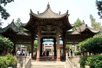
One of Ningxia's main tourist spots is the internationally renowned Xixia Tombs site located 30 km (19 mi) west of Yinchuan. The remnants of nine Western Xia emperors' tombs and two hundred other tombs lie within a 50 km2 (19 sq mi) area. Other famous sites in Ningxia include the Helan Mountains, the mysterious 108 stupas, the twin pagodas of Baisikou and the desert research outpost at Shapatou. A less visited tourist spot in Ningxia is the Mount Sumeru Grottoes (须弥山), which is among the ten most famous grottoes in China.[49]
المتاحف
- Ningxia Museum, opened in 1988
- Ningxia Transportation Museum, opened in August 2008
- Museum of Contemporary Art Yinchuan (MOCA Yinchuan), opened on 8 August 2015.
صور
-
-
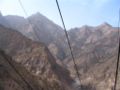 من تلفريك يصعد لقمة هلان شان
 -
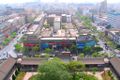 صورة جوية لمدينة ين چوان Yinchuan
 -
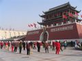 ميدان الشعب في ين چوان
 -
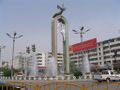 نافورة في ين چوان
 -
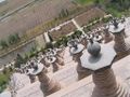 The 108 dagobas بالقرب من Qingtongxia


هامش
- ^ أ ب "Administrative Divisions (2013)". Ningxia Statistical Yearbook 2014 (in الإنجليزية). Statistical Bureau of Ningxia. Archived from the original on 4 March 2016. Retrieved 19 December 2015.
- ^ "Communiqué of the Seventh National Population Census (No. 3)" (in الإنجليزية). National Bureau of Statistics of China. 11 May 2021. Retrieved 11 May 2021.
- ^ GDP-2020 is a preliminary data "Home - Regional - Quarterly by Province" (Press release) (in الإنجليزية). China National Bureau of Statistics. March 1, 2021. Retrieved 31 December 2022.
- ^ United Nations Development Programme; China Institute for Development Planning at Tsinghua University; State Information Center (2019) (in en). China National Human Development Report Special Edition—In Pursuit of a More Sustainable Future for All: China's Historic Transformation over Four Decades of Human Development. Beijing: China Translation Publishing House. ISBN 978-7-5001-6138-7. Archived from the original. You must specify the date the archive was made using the
|archivedate=parameter. http://hdr.undp.org/sites/default/files/nhdr_cn.pdf. - ^ "By Choosing Assimilation, China's Hui Have Become One of the World's Most Successful Muslim Minorities". The Economist (in الإنجليزية). 8 October 2016. Retrieved 8 October 2016.
- ^ "Níngxià huízú zìzhìqū zīyuán gàikuàng" 宁夏回族自治区资源概况 [Overview of Resources in Ningxia Hui Autonomous Region]. Zhōngguó wǎng (in الصينية). 2009-12-17. Archived from the original on 2020-08-04. Retrieved 2 October 2018.
- ^ In China's Ningxia province, water shortage is so severe that the government is relocating people
- ^ خطأ استشهاد: وسم
<ref>غير صحيح؛ لا نص تم توفيره للمراجع المسماةbritannica - ^ Tobin, Meaghan (12 May 2019). "Can China Become the Wine World's Next California?". South China Morning Post (in الإنجليزية).
- ^ أ ب Ho, Peter (2000). "The Myth of Desertification at China's Northwestern Frontier: The Case of Ningxia Province, 1929-1958". Modern China (in الإنجليزية). 26 (3): 348–395. doi:10.1177/009770040002600304. S2CID 83080752.
- ^ Xu Xin, The Jews of Kaifeng, Ktav Publishing House, c. 2003.
- ^ Eiland, Murray L. (2003). "Carpets of the Ming Dynasty?". East and West. 53 (1/4): 179–208. ISSN 0012-8376.
- ^ Lin (2011), pp. 37–39.
- ^ China Archaeology and Art Digest, Volume 3, Issue 4. Art Text (HK) Ltd. 2000. p. 354. Retrieved 2010-11-28.
- ^ "Fourteen dead in mosque crush in China's Ningxia region". BBC. 6 January 2014.
- ^ yan, ed. (2014-01-06). English.news.cn (Xinhua). BEIJING http://news.xinhuanet.com/english/china/2014-01/06/c_133020252.htm.
{{cite news}}: Missing or empty|title=(help) - ^ Close, U., and McCormick (1922) "Where the mountains walked" National Geographic Magazine 41(5): pp.445–464.
- ^ Feng, X. and Guo, A. (1985) "Earthquake landslides in China" In Proceedings, IVth International Conference and Field Workshop on Landslides pp. 339–346, Japan Landslide Society, Tokyo, OCLC 70324350.
- ^ Haines, Lester (19 July 2006)."Chinese black helicopters circle Google Earth". The Register
- ^ Cassidy, Katherine (13 September 2006). "Armchair Sleuths Uncover Strange Military Sites in China". McClatchy Newspapers / Real Cities Network.
- ^ Ningxia Bureau of Statistics, 2013, 1.2
- ^ أ ب ت ث Ho, Peter (2016). "Empty Institutions, Non-Credibility and Pastoralism: China's Grazing Ban, Mining and Ethnicity". The Journal of Peasant Studies (in الإنجليزية). 43 (6): 1145–1176. doi:10.1080/03066150.2016.1239617. S2CID 157632052.
- ^ Ho, Peter; Azadi, Hossein (2010). "Rangeland Degradation in North China: Perceptions of Pastoralists". Environmental Research (in الإنجليزية). 110 (3): 302–307. Bibcode:2010ER....110..302H. doi:10.1016/j.envres.2009.12.007. PMID 20106474.
- ^ Ho, P. (2001). "Rangeland Degradation in North China Revisited? A Preliminary Statistical Analysis to Validate Non-Equilibrium Range Ecology". The Journal of Development Studies. 37 (3): 99–133. doi:10.1080/00220380412331321991. S2CID 154397243.
- ^ Ho, Peter (2003). "Mao's War against Nature? The Environmental Impact of the Grain-First Campaign in China". The China Journal (in الإنجليزية). 50 (50): 37–59. doi:10.2307/3182245. JSTOR 3182245. S2CID 144410824.
- ^ Zhou, Z. 2013. A view of Ningxia ten years since the grazing ban [Jìn mù yī nián kàn Níngxià]. People's Daily, 29 June. p. 10.
- ^ "Ningxia og Sogn og Fjordane eit steg vidare på samarbeidsvegen". Sfj.no. Retrieved 2015-05-07.
- ^ "中华人民共和国县以上行政区划代码". 中华人民共和国民政部.
- ^ 深圳市统计局. 《深圳统计年鉴2014》. 中国统计出版社. Retrieved 2015-05-29.
{{cite book}}:|work=ignored (help) - ^ shi, Guo wu yuan ren kou pu cha ban gong; council, Guo jia tong ji ju ren kou he jiu ye tong ji si bian = Tabulation on the 2010 population census of the people's republic of China by township / compiled by Population census office under the state; population, Department of; statistics, employment statistics national bureau of (2012). Zhongguo 2010 nian ren kou pu cha fen xiang, zhen, jie dao zi liao (Di 1 ban. ed.). Beijing Shi: Zhongguo tong ji chu ban she. ISBN 978-7-5037-6660-2.
{{cite book}}: CS1 maint: numeric names: authors list (link) - ^ 中华人民共和国民政部 (August 2014). 《中国民政统计年鉴2014》. 中国统计出版社. ISBN 978-7-5037-7130-9.
- ^ Ningxia Bureau of Statistics 2013, 4.2
- ^ Ningxia Bureau of Statistics 2013, 11.20
- ^ "Grape expansion: Chinese wine companies move west" Archived 31 يوليو 2015 at the Wayback Machine, Want China Times, 15 December 2011. Retrieved 17 December 2011.
- ^ Phillips, Tom (14 June 2016). "China's Bordeaux: winemakers in 'gold rush' to turn desert into vineyards". The Guardian. Helan county, Ningxia province.
- ^ 欢迎访问银川经济技术开发区网站. Ycda.gov.cn. 24 April 2015. Retrieved 7 May 2015.
- ^ 1912年中国人口. Retrieved 6 March 2014.
- ^ 1928年中国人口. Retrieved 6 March 2014.
- ^ 1936-37年中国人口. Retrieved 6 March 2014.
- ^ 1947年全国人口. Retrieved 6 March 2014.
- ^ 中华人民共和国国家统计局关于一九八二年人口普查主要数字的公报. National Bureau of Statistics of China. Archived from the original on 10 May 2012.
- ^ 中华人民共和国国家统计局关于一九九〇年人口普查主要数据的公报. National Bureau of Statistics of China. Archived from the original on 19 June 2012.
- ^ 现将2000年第五次全国人口普查快速汇总的人口地区分布数据公布如下. National Bureau of Statistics of China. Archived from the original on 29 August 2012.
- ^ "Communiqué of the National Bureau of Statistics of People's Republic of China on Major Figures of the 2010 Population Census". National Bureau of Statistics of China. Archived from the original on 27 July 2013.
- ^ "Key Takeaways from China's 2020 Population Census". Reuters (in الإنجليزية). 11 May 2021.
- ^ أ ب Min Junqing. The Present Situation and Characteristics of Contemporary Islam in China. JISMOR, 8. 2010 Islam by province, page 29. Data from: Yang Zongde, Study on Current Muslim Population in China, Jinan Muslim, 2, 2010.
- ^ أ ب China General Social Survey 2004. Report by: Xiuhua Wang (2015, p. 15)
- ^ "خىتاي ھۆكۈمىتى نىڭشيادا «ئەرەبلىشىش» نى چەكلەشكە باشلىدى". راديو آسيا الحرة. 2017-01-05.
- ^ "Guyuan Travel Guide: Map, Location, Climate, Attractions". travelchinaguide.com (in الإنجليزية). Retrieved 29 January 2015.
وصلات خارجية
- Ningxia regional government website (بالصينية المبسطة)
- Large map of Ningxia
- (صينية) Ningxia-Hui Autonomous Region statistics for 2005 at China.com.cn
- Article on Wolfberries, with image of fruit from Ningxia being dried in the sun after picking
أماكن قريبة من نينغشيا | ||||||||||
|---|---|---|---|---|---|---|---|---|---|---|
| ||||||||||
| مقاطعات |  | |
|---|---|---|
| مناطق الحكم الذاتي | ||
| البلديات | ||
| SAR | ||
1 تايوان تطالب بها جمهورية الصين الشعبية إلا أن جمهورية الصين(ROC) تديرها. انظر الوضع السياسي لتايوان. | ||
- CS1 uses الصينية-language script (zh)
- CS1 الصينية-language sources (zh)
- Harv and Sfn no-target errors
- CS1 errors: missing title
- CS1 errors: bare URL
- CS1 errors: periodical ignored
- CS1 maint: numeric names: authors list
- CS1 uses اليابانية-language script (ja)
- Short description is different from Wikidata
- Articles containing صينية-language text
- Pages using multiple image with auto scaled images
- Pages using infobox settlement with no coordinates
- Articles containing Pinyin-language text
- Pages using gadget WikiMiniAtlas
- نينگشيا
- المناطق المستقلة ذاتياً في جمهورية الصين الشعبية
- الصين الغربية
- ولايات وأراضي تأسست في 1958