نيوپورت، رود آيلاند
Newport, Rhode Island | |
|---|---|
City | |
 Newport Rhode Island Aerial View | |
| الكنية: المدينة على البحر، عاصمة الابحار الشراعي للعالم، ملكة الصيف والمنتجعات، عاصمة المجتمع الراقي الأمريكي | |
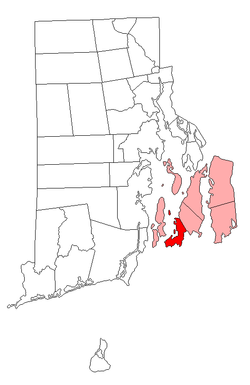
 Location of Newport in Newport County, Rhode Island | |
| الإحداثيات: 41°29′17″N 71°18′45″W / 41.48806°N 71.31250°W | |
| البلد | الولايات المتحدة |
| الولاية | رود أيلاند |
| المقاطعة | نيوپورت |
| Incorporated (city) | 1784 |
| Incorporated (town) | 1639 |
| الحكومة | |
| • العمدة | Henry F. Winthrop |
| المساحة | |
| • الإجمالي | 29٫5 كم² (11٫4 ميل²) |
| • البر | 19٫9 كم² (7٫7 ميل²) |
| • الماء | 9٫6 كم² (3٫7 ميل²) |
| المنسوب | 9 m (30 ft) |
| التعداد (2010) | |
| • الإجمالي | 24٬672 |
| • الكثافة | 1٬239٫8/km2 (3٬211/sq mi) |
| منطقة التوقيت | UTC-5 (EST) |
| • الصيف (التوقيت الصيفي) | UTC-4 (EDT) |
| ZIP codes | 02840-02841 |
| مفتاح الهاتف | 401 |
| FIPS code | 44-49960[1] |
| GNIS feature ID | 1217986[2] |
| الموقع الإلكتروني | www |
نيوپورت Newport هي مدينة على ساحل المحيط في جزيرة أكويدنك في مقاطعة نيوپورت، رود آيلاند، الولايات المتحدة. وتقع على بعد 23 ميل (37 km) جنوب پروڤيدنس، و 61 ميل (98 km) جنوب بوسطن. وتُعرف بأنها منتجع صيفي في نيو إنگلاند وبـقصور نيوپورت الشهيرة، وهي مقر جامعة سالڤى رجينا والمحطة البحرية نيوپورت التي تأوي كلية الحرب البحرية الأمريكية، مركز القتال تحت البحر، ومركز تدريب للبحرية الأمريكية رئيسي. وكانت ميناء رئيسي في القرن 18، وتضم الآن أحد أكبر الأعداد المباني التاريخية الباقية من الحقبة الاستعمارية في أي مدينة بالولايات المتحدة.[3] المدينة هي مقر مقاطعة نيوپورت (وهي المقاطعة التي تم تضم أي وظائف حكومية عدا ادارة محكمة وحدود شريف الشرطة). ونيوپورت كانت تُعرف بأنها المدينة التي تضم بعض "البيت الأبيض الصيفي" أثناء ادارتي الرئيسين دوايت أيزنهاور وجون ف. كندي. بلغ تعدادها 24,672 في تعداد 2010.[4]
التاريخ
كنيس تورو، أقدم كنيس باقي في الولايات المتحدة
تذكار أوليڤر پري في منتزه أيزنهاور
عصر الثورة الأمريكية

During the American Revolution, Newport was the scene of much activity. One of the signers of the Declaration of Independence, William Ellery, came from Newport. He later served on the Naval Committee.
In the winter of 1775 and 1776, the Rhode Island Legislature put militia General وليام وست in charge of rooting out loyalists in Newport, and several notable individuals such as Joseph Wanton and Thomas Vernon[بحاجة لتوضيح] were exiled to the northern part of the state.[5] In the fall of 1776, the British, seeing that Newport could be used as a naval base to attack New York (which they had recently occupied) took over the city. The population of Newport had divided loyalties and many pro independence "Patriots" left town while loyalist "Tories" remained. For the next three years Newport was a British stronghold.
In the summer of 1778, the Americans began the campaign known as the معركة رود آيلاند. This was the first joint operation between the Americans and the French after the signing of the Treaty of Alliance. The Americans based in Tiverton, planned a formal siege of the town. However, the French (wanting a frontal assault) refused to take part in the siege. This weakened the American position and the British were able to expel the Americans from the island. The following year, the British, wanting to concentrate their forces in New York, abandoned Newport.
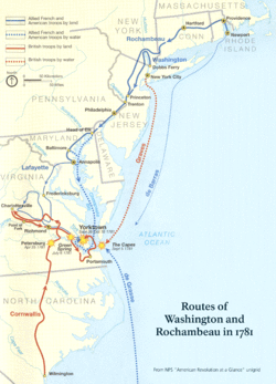
في 10 يوليو 1780، وصلت تجريدة فرنسية أرسلها الملك لويس السادس عشر بقيادة روشامبو على رأس جيش من 450 ضابط و 5,300 جندي في خليج نراگانست أمام نيوپورت. For the rest of the war Newport was the base of the French forces in the United States. In July 1781, Rochambeau was finally able to leave Newport for Providence to begin the decisive march to Yorktown, Virginia along with General George Washington. The first Catholic mass in Rhode Island was said in Newport during this time. Rochambeau Monument in Kings Park on Wellington Avenue along Newport Harbor commemorates Rochambeau's contributions to the Revolutionary War and to Newport's history.
By the time the war ended (1783) Newport's population had fallen from over 9,000 (according to the census of 1774) to less than 4,000. Over 200 abandoned buildings were torn down in the 1780s. Also, the war destroyed Newport's economic wealth, as years of military occupation closed the city to any form of trade. The Newport merchants moved away, some to Providence, others to Boston and New York.
It was in Newport in 1791 that the Rhode Island General Assembly, acting under pressure from the merchant community of Providence, voted to ratify the Constitution and become the 13th state.
The city is the site of the last residence of Commodore Oliver Hazard Perry, the birthplace of Commodore Matthew C. Perry and the Reverend William Ellery Channing.
العصر المذهـَّب
Beginning in the mid-nineteenth century, wealthy southern planters seeking to escape the heat began to build summer cottages on Bellevue Avenue such as Kingscote (1839).[6] Around the middle of the century, wealthy Yankees such as the Wetmore family also began constructing larger mansions such as Chateau-sur-Mer (1852) nearby.[7] Most of these early families made a substantial part of their fortunes in the Old China Trade.[8]
By the turn of the 20th century, many of the nation's wealthiest families were summering in Newport, including the Vanderbilts, Astors and Widener family who constructed the largest "cottages", such as The Breakers (1895) and Miramar.[9] They came for a brief social season to grand, gilded mansions with elaborate receiving, dining, music and ballrooms, but with few bedrooms, since the guests were expected to have cottages of their own. Many of the homes were designed by the New York architect Richard Morris Hunt, who himself kept a house in Newport.
الجغرافيا
المناخ
الديمغرافيا
| Historical populations | |||
|---|---|---|---|
| الإحصاء | التعداد | %± | |
| 1790 | 6٬716 | ||
| 1800 | 6٬739 | 0.3% | |
| 1810 | 7٬907 | 17.3% | |
| 1820 | 7٬319 | -7.4% | |
| 1830 | 8٬010 | 9.4% | |
| 1840 | 8٬333 | 4.0% | |
| 1850 | 9٬563 | 14.8% | |
| 1860 | 10٬508 | 9.9% | |
| 1870 | 12٬521 | 19.2% | |
| 1880 | 15٬693 | 25.3% | |
| 1890 | 19٬457 | 24.0% | |
| 1900 | 22٬441 | 15.3% | |
| 1910 | 27٬149 | 21.0% | |
| 1920 | 30٬255 | 11.4% | |
| 1930 | 27٬612 | -8.7% | |
| 1940 | 30٬532 | 10.6% | |
| 1950 | 37٬564 | 23.0% | |
| 1960 | 47٬049 | 25.3% | |
| 1970 | 34٬562 | -26.5% | |
| 1980 | 29٬259 | -15.3% | |
| 1990 | 28٬227 | -3.5% | |
| 2000 | 26٬475 | -6.2% | |
| 2010 | 24٬672 | -6.8% | |
المدن الشقيقة
 اليابان: Shimoda
 أيرلندا: Kinsale
 الپرتغال: Ponta Delgada
 إيطاليا: Imperia
 اليونان: Skiathos
 كندا: Saint John, New Brunswick
 السويد: Malmö
شخصيات جديرة بالذكر
انظر أيضاً
الهامش
- ^ "American FactFinder". United States Census Bureau. Retrieved 2008-01-31.
- ^ "US Board on Geographic Names". United States Geological Survey. 2007-10-25. Retrieved 2008-01-31.
{{cite web}}: Check date values in:|date=(help) - ^ James D. Kornwolf, Georgiana Wallis Kornwolf, Architecture and town planning in colonial North America, Volume 1 (JHU Press, 2002), pg. 1021 http://books.google.com/books?id=DA9_v6Ma1a8C&source=gbs_navlinks_s
- ^ "Profile of General Population and Housing Characteristics: 2010 Demographic Profile Data (DP-1): Newport city, Rhode Island". U.S. Census Bureau, American Factfinder. Retrieved March 6, 2013.
- ^ Vernon, Thomas; Rider, Sidney Smith; Ellery, Harrison; Greene, George Sears (1879). The Diary of Thomas Vernon. S.S. Rider.
- ^ "Kingscote". The Preservation Society of Newport County.
- ^ "Chateau-sur-Mer". The Preservation Society of Newport County.
- ^ Michie, Thomas (1995-04-01). "Newport and the Far East. (Newport, Rhode Island)". The Magazine Antiques.
- ^ "The Breakers". The Preservation Society of Newport County.
للاستزادة
- S. G. Arnold, History of the State of Rhode Island, (two volumes, New York, (1859–60)
- G. C. Mason, Reminiscences of Newport, (Newport, 1884)
- E. M. Stone, Our French Allies, (Providence, 1884)
- Newport History, the journal of the Newport Historical Society
- C. P. B. Jefferys, Newport: A Short History (1992)
- Newport Mansions: Postcards of the Gilded Age, Schiffer Publishing
وصلات خارجية
- City of Newport official website
- "Class and Leisure at America's First Resort: Newport 1870–1914" from American Studies at the University of Virginia
- Pages using gadget WikiMiniAtlas
- Short description is different from Wikidata
- Pages using infobox settlement with unknown parameters
- Articles with links needing disambiguation from February 2013
- Articles with hatnote templates targeting a nonexistent page
- Pages with empty portal template
- Portal-inline template with redlinked portals
- Coordinates on Wikidata
- نيوپورت، رود آيلاند
- مدن رود آيلاند
- County seats in Rhode Island
- عواصم سابقة لولايات أمريكية
- Historic Jewish communities in the United States
- Populated places established in 1639
- Cities in Newport County, Rhode Island
- Seaside resorts in the United States
- Providence metropolitan area


